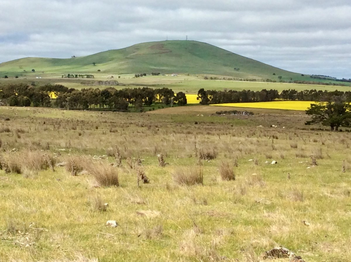

Mount Moorookyle (left), Green Hill & Mount Kooroocheang (right), looking north from Kingston, with canola in foreground
‘Six Peaks Speak’: State Library Victoria Creative Fellowship: Regional, research and writing project in 2023
Six Peaks Speak: Unsettling Legacies in southern Dja Dja Wurrung Country by Barry Golding & Clive Willman was published in hardcover in late 2024 by Common Ground Research Networks, US. It was officially launched on International Mountain Day in Castlemaine on 11 Dec 2024.
- Available as a 432 page, hard cover or soft cover book, or as a pdf.
- Hard cover (late 2024) version, available from Barry Golding for AUD$79; add $10 per copy for postage within Australia (order via b.golding@federation.edu.au ).
- Soft cover (Sept 2025) version, also 432 pages, published with revisions in Sept 2025: author copies available from Barry Golding for AUD$59; add $12 for postage within Australia (order via b.golding@federation.edu.au ).
- Available for order online internationally via CGRN bookshop: https://cgscholar.com/bookstore/works/six-peaks-speak (US$75 for hard cover book: total delivered approx. AUD$131 depending on exchange rate; also available as pdf US$25, approx. AUD$38). Soft cover $USD$50.
- Purchase in store (RRP approx. AUD$99) at: Stoneman’s Bookroom (Castlemaine), Paradise Bookshop (Daylesford), BOOM Clunes, Collins on Lydiard (Ballarat).
- Purchase online at various prices via several online book retailers, including Booktopia & Amazon
In Praise of Six Peaks Speak (reader reviews)
Edited versions of the following reader reviews have been added inside the cover of the soft cover version of our book.
- ‘This is a wonderful contribution to our knowledge of Country.’ Bruce Pascoe, First Nations writer and farmer; publisher of 36 books including ‘Dark Emu’
- ‘This is a captivating journey, highly timely in national discourse and knowledge gap-filling, in that it brings together lenses rarely seen before. We can benefit from the many vantages and vistas in this book. It reminds us of the importance of place and a desired future where we respect Country and respect one another in it.’ Professor Tony Dreise, Pro Vice-Chancellor, Indigenous Engagement, Charles Sturt University & Gamilaraay First Nations person
- ‘Barry Golding speaks with care and an enduring need for us all to be at our own peaks, not just the hills in this book, their geology, flora and fauna. … Thank you for choosing these Six Peaks that are special to me also, and for being their friend, for they could not ask for anyone better. Dhelkup Murrupuk, we give you good spirit.’ (in book’s preface) Rodney Carter, Dja Dja Wurrung Chief Executive Officer
- ‘Golding uses “unsettling” and ‘legacies” … in striking ways to show how land and past influence present and future … This is a history unlike any I have read, regional in focus but universal in argument and I hope readership. It ranges from deep geological time to calls for future repair and restoration. It argues for Dja Dja Wurrung expertise to be recognised, and for Aboriginal people everywhere to be given a fair go. It adds depth and detail to what informed locals know, is crowded with instances of past injustices and misuse, and firm for better management of the land. … No-one else could write this book. It needed locals to spend decades tramping or cycling the land, seeing and questioning as Golding and Willman have. … From both fieldwork and paper, things great and small speak. This book is bubbling with insights and remedies. Golding and Willman enlighten not only where they live, but where you do.’ Bill Gammage: Author of The Biggest Estate on Earth: How Aborigines Made Australia
- ‘The deep and painstaking research undertaken to bring this book together is significant and impressive. The narrative style, interweaving history of the locations with geology make this book unique, quite beautiful and accessible to a broader audience. It involves a discussion about deeply unsettling legacies, highly relevant today in Australia. It is indeed powerful and disquieting at the same time.’ Professor Annette Foley, Professor of Vocational and Adult Education, Federation University
- ‘Six Peaks Speak is an outstanding work of careful and thoughtful research and an engaging, thought-provoking and ultimately hope-inspiring read. I found it incredibly illuminating on the geological and more recent history of the district, its present and its future. This is essential reading for anyone interested in the way colonial violence and its legacies are woven into this landscape’. Patrick Stokes, Associate Professor of Philosophy, Deakin University
- ‘Professor Golding presents a cultural and environmental history of landscape in central Victoria, Australia. His vision is for a reconciled relationship on Country. He extends First Nations people respect that has been missing until recently in Australian historiography, providing an important model of how non-Indigenous Australians should engage with traditional owners in research and writing projects.’ Dr Stephen Carey, Senior Research Fellow, Federation University
- ‘I’ve just finished reading your magnificent book. … I enjoyed your writing style, while learning so much about the formation and unfortunate histories of the six peaks – along with your own impressive voyage of discovery, commitment, detailed research and personal observations. It should be essential reading for all land managers.’ Terry Bellair, Environmental Scientist, Castlemaine
- ‘I really loved the integrated, multi-disciplinary approach to the study. The way you were able to weave geographical, spatial, ecological, geological and topographical observations/sciences/stories together with social, economic, political and personal histories was great. There are some overarching, binding aspects as well: historiography and how writing and research work as political intent/action. But keeping all those thematic balls in the air and maintaining a coherent structure and narrative is really quite a feat. … Congratulations Barry. Brilliant stuff.’ David Jay, former Museum Educator, Melbourne
- ‘Six Peaks Speak is thorough, respectful, personal, intimate, illuminating and engaging. It is an immersion in landscape, environment, culture and history. It is an extremely authentic, well-researched and totally accessible account. The timing, depth and impact of your narrative challenges readers to learn, understand and commit to personal actions. These actions should address historical and current cultural and environmental issues of local, regional or national significance. As you have committed to over your lifetime, we all need to build respectful relationships with First Nations communities and seek to address historical wrongs where we can.’ Neville Oddie OAM, farmer, Chepstowe
- ‘Congratulations on a seriously great historical tome built on firm foundations not on the shifting sands of imagination.’ Gib Wettenhall OAM, writer, editor & EmPress publisher, Mollongghip
- ‘Congratulations on your academic but readily readable book. Your detailed examination of the economic history of the area since ‘unsettlement’ is fascinating, as is the role of government decisions. Above all, the reader is rivetted by your detailed and impassioned study of the profound impact of ‘unsettlement’ of Aboriginal people. Waves of indignation, anger and grief surge through this incredible book. More comfortably, one is uplifted by the theme of the six beautiful peaks and their emotional effect of those who visit them.’ Bill Golding, OAM, Founder of Great South West Walk, Portland (Barry Golding’s 92 year old great uncle)
- ‘The book has got me into my region more deeply and I feel even more ‘at home’. The connection of geology with habitat and resources is striking and places human occupation in context. The archaeological presences are revealing. As a former bureaucrat, the existence of documents and your use of them is impressive. Their importance in telling the ‘unsettling’ story is clear.’ Geoff Hannon, Castlemaine
- ‘The voice in this book is deliciously knowing and humble. Readers from all walks will soon realise that the pages of Six Peaks Speak are safe for opening up old assumptions or ways of thinking, as well as engaging in the sensitive practice of learning completely new information. The book is astoundingly rich. It invites others to contemplate local history, the breathing community of our environment in a way which invites them to be active and valuable in the present. Perhaps it’s showing a good of deal you and your truth, but it seeps across to house an entire body of readers. It is in itself, part of an ecotone where we will come to eat, drink and listen’. Amy Fleet, Mollongghip; also Werona north of Gurutjanga
Honorary Professor Barry Golding AM
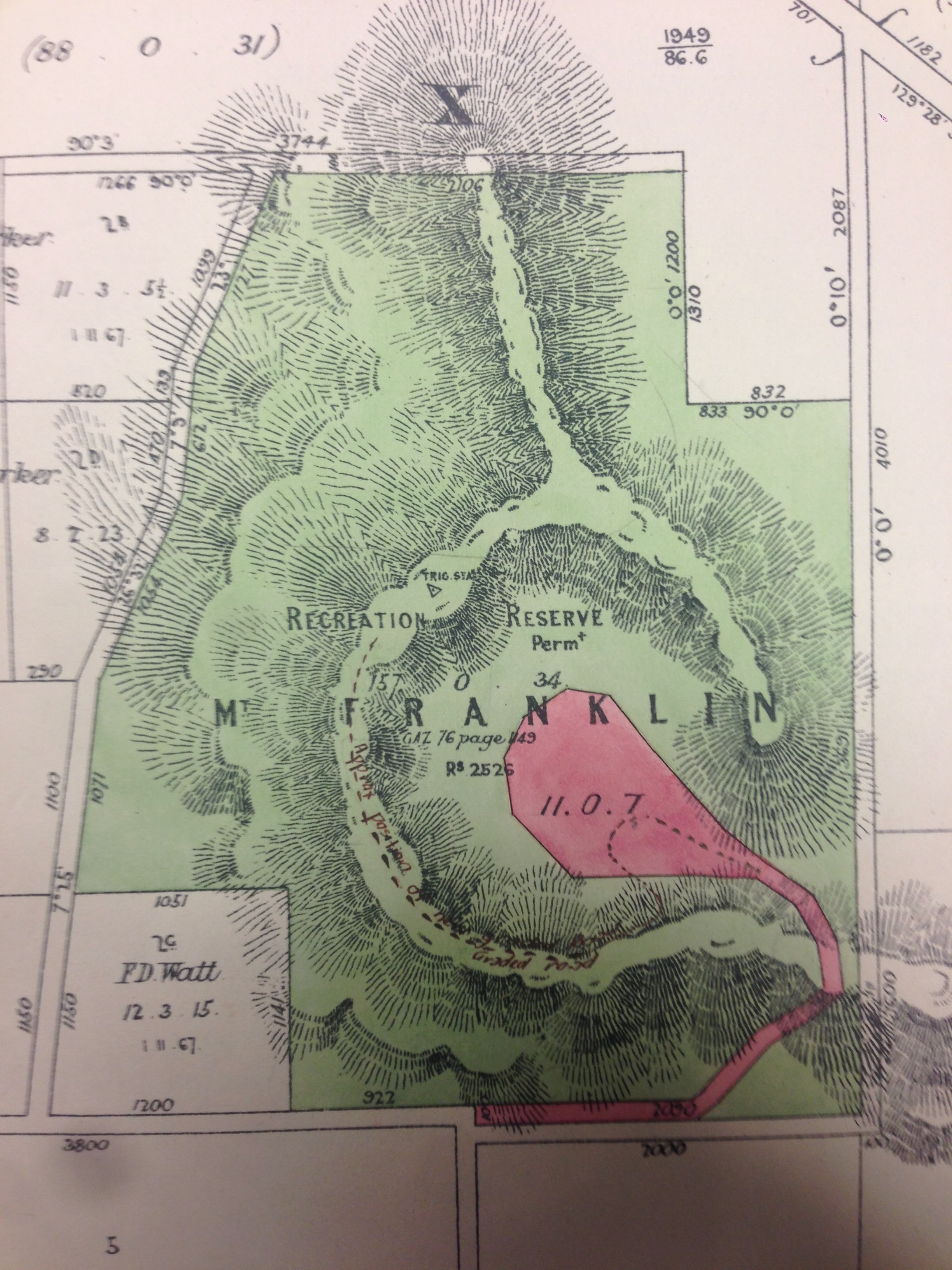
Mount Franklin (‘permanent’) Recreation Reserve, Land Manager Files
‘Six Peaks Speak’ was a research and writing project Barry Golding undertook as a State Library Victoria (SLV) Creative Fellow in 2023. It resulted in the publication of a book, Six Peaks Speak: Unsettling legacies in southern Dja Dja Wurrung Country in November 2024, published in the US via Common Ground Research Networks.
The State Library Victoria Fellowship generously provided Barry with a shared office space within SLV in Melbourne and well as library search and some financial support during 2023. This gave time, space, advice and resources to research and write stories about six of the peaks visible from his home in southern Dja Dja Wurrung Country. The six peaks are Mounts Kooroocheang, Beckworth, Greenock, Tarrengower, Alexander / Leanganook and Franklin / Larni barramal.
‘Six Peaks Speak’ sought to give voice to changes from the perspective of six iconic peaks in southern Dja Dja Wurrung Country in central Victoria, briefly summarised in the Six Peaks Table, below. The peaks are located in a broad oval enclosing and overlooking some the richest and previously most densely populated Aboriginal grasslands in Australia.
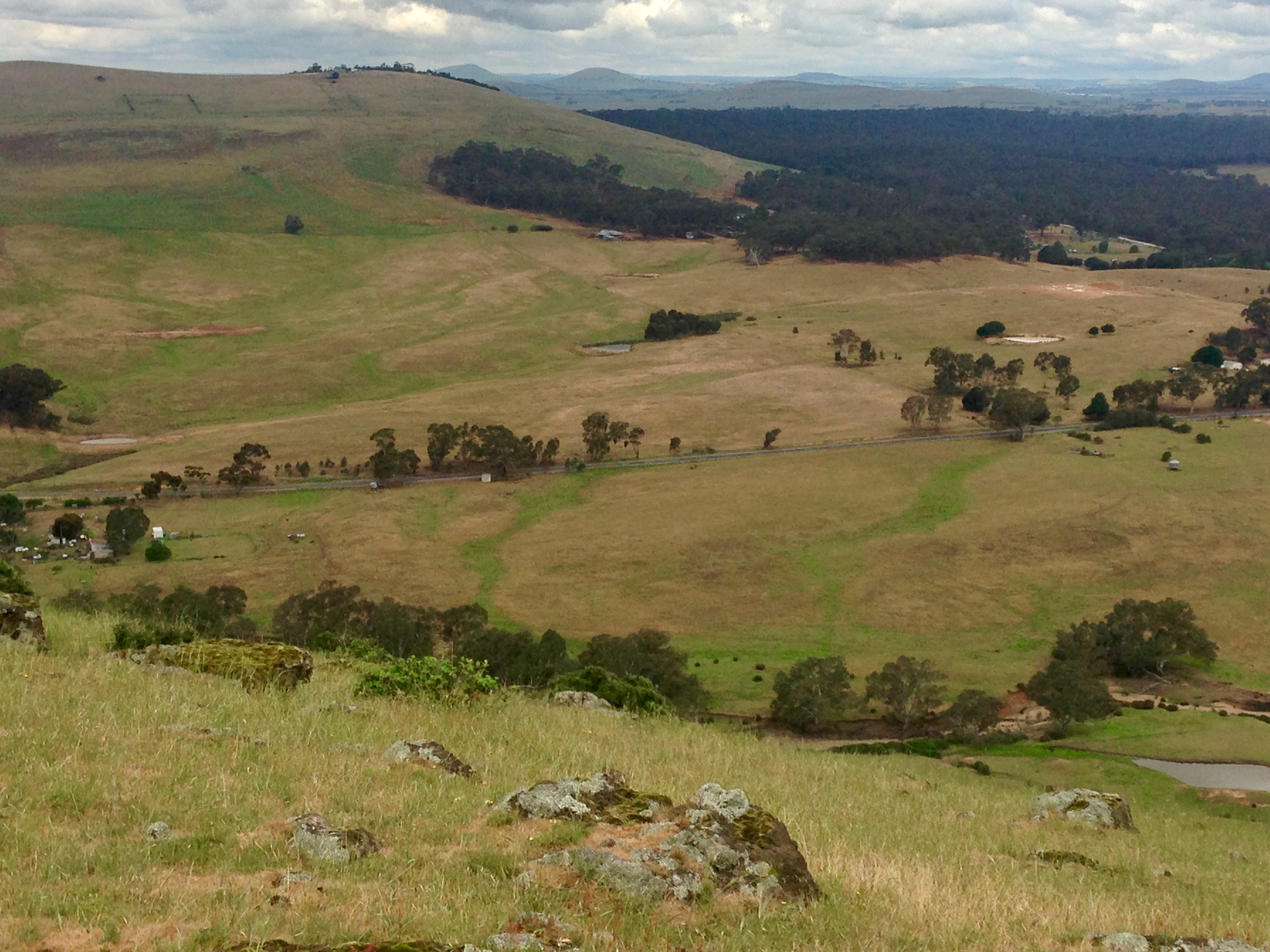
View east from Mount Greenock, with Mount Glasgow in left foreground McCallum Creek in between; peaks on far horizon include Mounts Kooroocheang & Moorookyle; Eglinton Forest in between.
The Six Peaks
Six Peaks Speak Table
| Mounts (Shire, nearby town) | Height (m) | Number of visible Peaks (Highest) | Geology | Dja Dja Wurrung |
| Alexander (Alexander, Castlemaine) | 744 | 267 (Buller) | Granitic | Liyanganuk |
| Kooroocheang (Hepburn, Smeaton) | 669 | 189 (Camels Hump) | Volcanic | Gurutjanga |
| Beckworth (Hepburn, Clunes) | 629 | 180 (Camel’s Hump) | Granitic | Nyaninuk |
| Franklin (Hepburn, Franklinford) | 627 | 173 (Camel’s Hump) | Volcanic | Lalkambook & Larni barramal crater |
| Tarrangower (Alexander, Maldon) | 571 | 193 (Camel’s Hump) | Granitic | Dharrang Guava |
| Greenock (Golden Plains, Talbot) | 385 | 105 (Buangor) | Volcanic | ?? |
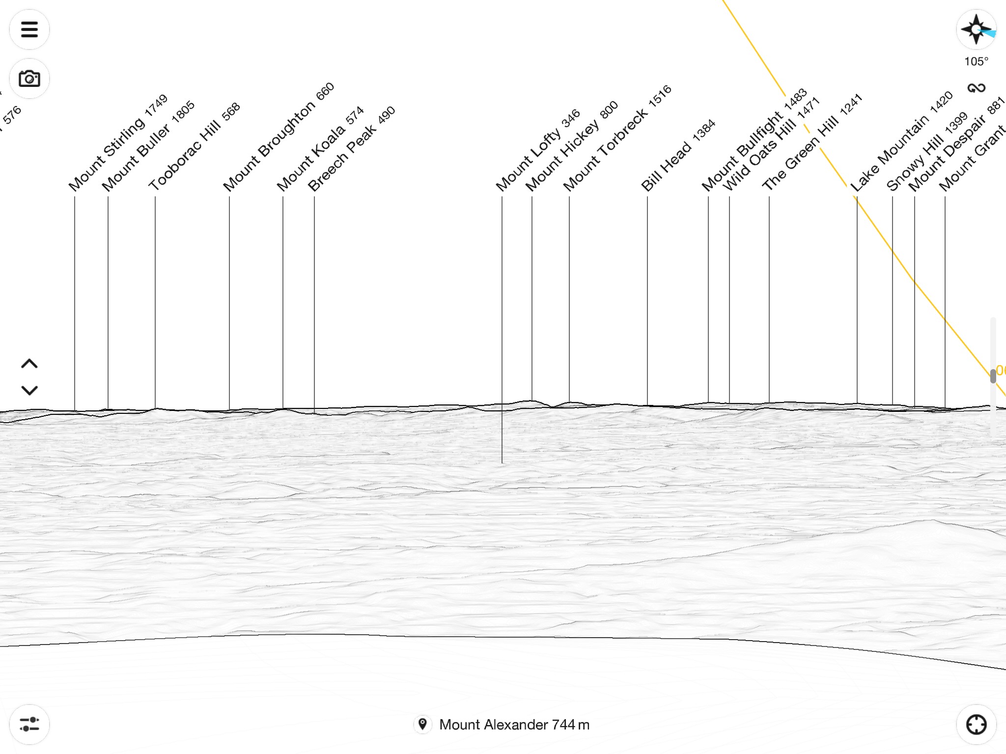
Some of the 267 Peaks within line of sight of Mount Alexander / Liyanganuk (744m) summit (PeakFinder App)
All peaks tower above the surrounding plains and forests, keeping watch over and bearing seldom-told witness to significant change. Barry’s research for each mountain focused on ‘Incursions’, ‘Resistances’ and ‘ Opportunities’, combining insights from a wide range of SLV, PROV and other sources and fields (First Nations, spatial, geological, historical, ecological, artistic, environmental), aiming to throw a new light on how the peaks were shaped, and how human contact has continued to define and shape their destinies, after two centuries of mapping, exploitation, public management, visitation and use.
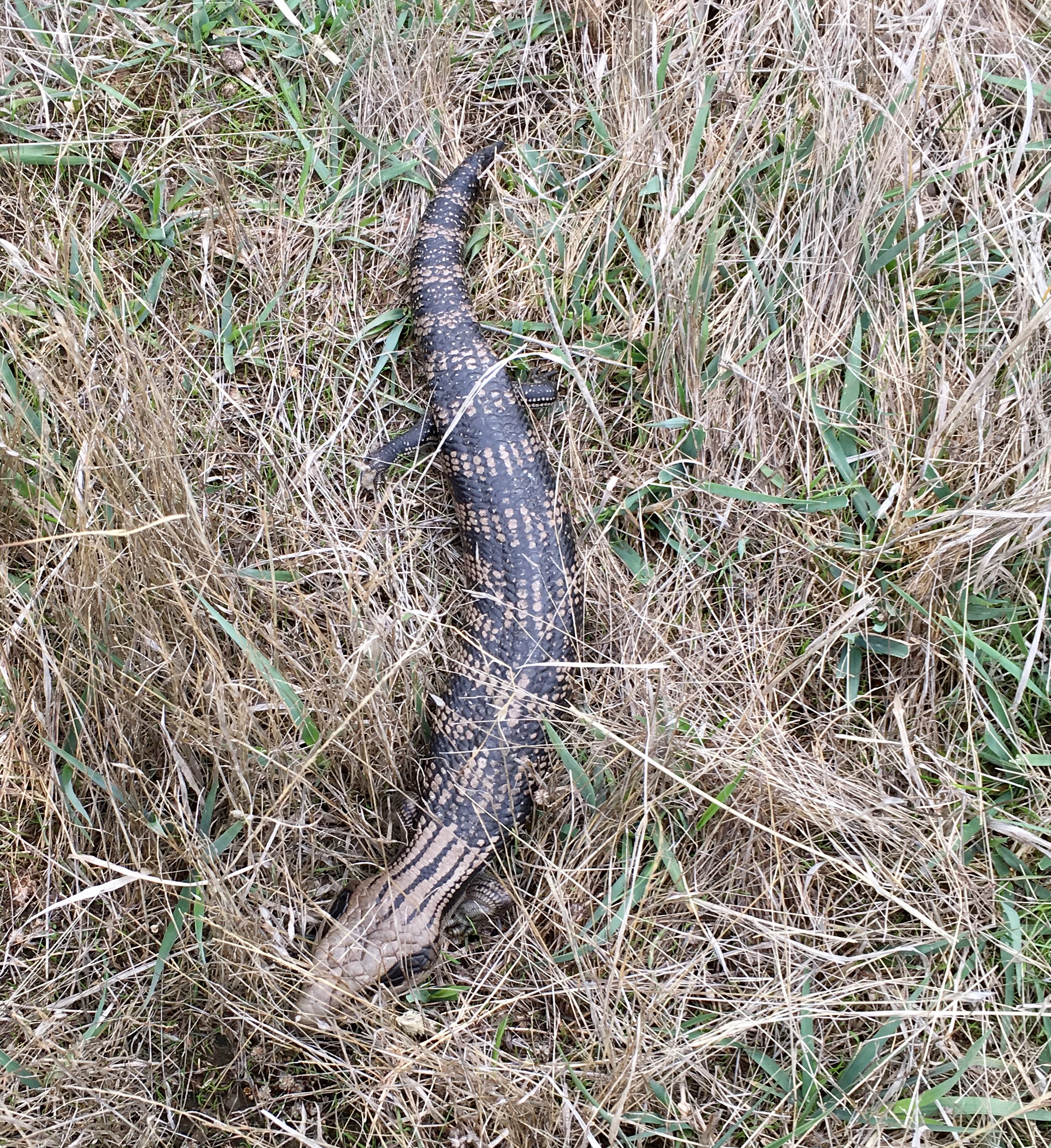
[ABOVE] Blue tongue Lizard (Tiliqua scincoides) on the southern flank of Mount Kooroocheang
[BELOW] Deep Lead gold mines on the northern flank of Mount Greenock

How did the ‘Six Peaks Speak’ Project originate?
Barry’s idea goes back around five years when he was researching the history of Mount Franklin, a publicly reserved volcanic cone today smothered by pine trees. He was astounded when he accessed the thick, accumulated historic file held by regional land managers about Mount Franklin in the regional State government office. Here were local people in the 1870s petitioning the government for the mountain’s natural beauty to be forever retained. Yet by 1960, the mountain slopes were so degraded due to mismanagement, bushfires, rabbits, uncontrolled grazing and timber removal, it was totally planted out to pine trees, despite local resistance. Primary evidence and stories about this and many other incursions and resistances on all six peaks will be discoverable by searching the voluminous SLV records.
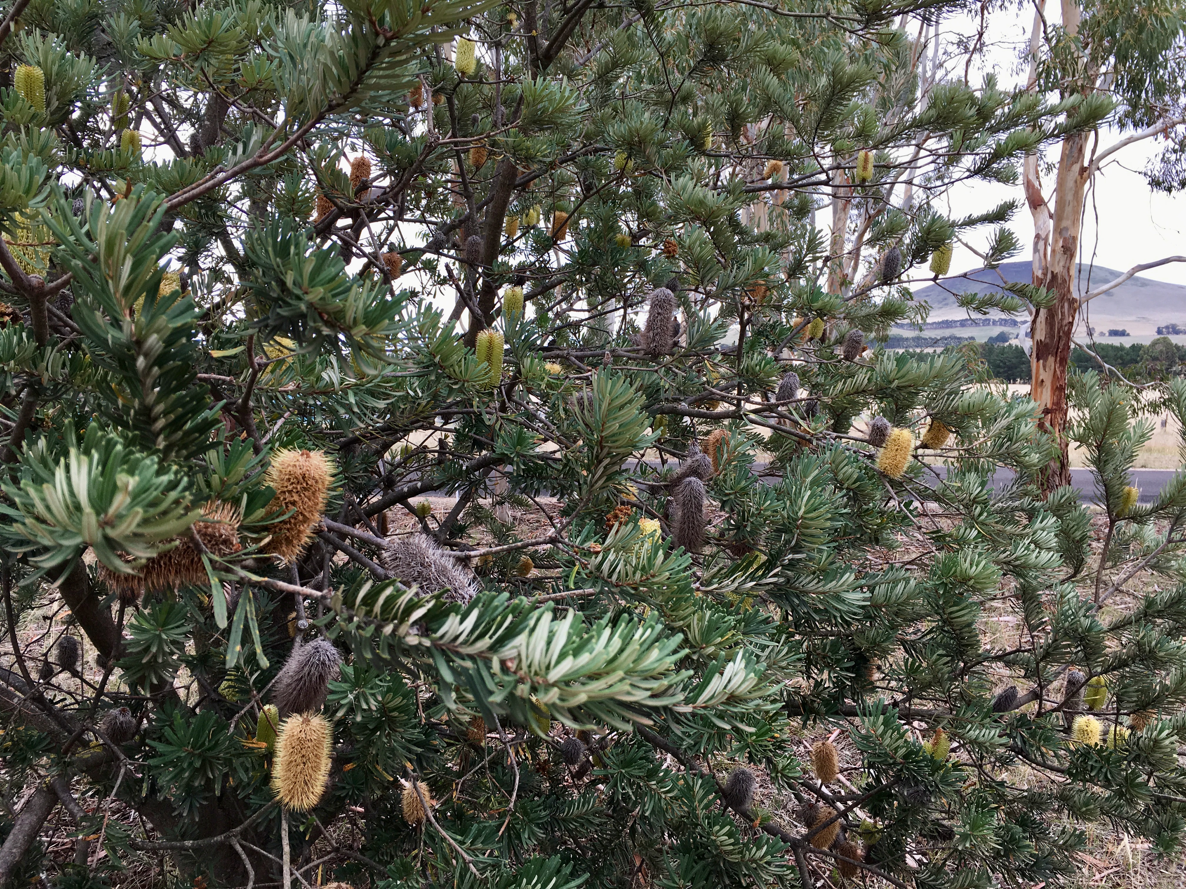
Mt Kooroocheang viewed through roadside Silver Banksia on White Hills Road
What resources were accessed?
Barry’s SLV Creative Fellowship Regional project was focused on just six peaks. His research about these mountains (presently known as Alexander, Kooroocheang, Beckworth, Franklin, Tarrangower & Greenock) was deliberately broad. So too was the range of SLV resources. It included accounts of these peaks from early unsettler families and ‘explorers’, Dja Dja Wurrung people, Aboriginal Protectors, early surveyors as well as from mining, quarrying, local government and forestry records, books, rare books, history and scientific journals, photographs, artworks, memoirs, diaries in research collections, maps and plans. These were enhanced by historic government Crown Reserve management files and local and regional museum records held elsewhere as well as oral histories: in effect, whatever resources helped the peaks tell their tales.
Lower flank of Mount Alexander / Leanganook
What will the outcomes be?
The Fellowship research and writing project was underpinned by access to original and published material from within and beyond SLV collections. It made it possible for Barry to fulfil a long held twin dream. First, to provide reliable and accessible information about the potential for public lands, specifically about well-known reserves surrounding these five regionally iconic mountain peaks, to be better understood as unique ecosystems and First Nations sentinels of change, and managed more responsibly and sustainably in perpetuity. Second, to write a book about regionally iconic peaks taking proper, informed account of their many layers and communities of interest, inclusive of First Nations people’s knowledges and ongoing responsibilities to care for Country.

Gurutjanga / Mount Kooroocheang from the south; black soil in the ploughed paddock in the foreground is from an Aboriginal oven mound
Barry Golding’s Acknowledgements
I acknowledge that all six peaks, as well as where was born, live and work, are within Dja Dja Wurrung Country. I acknowledge the traditional owners of the land, the Dja Dja Wurrung people including their and Elders past and present. I am grateful of the strong support for my Fellowship and my work from the relevant First Nations organisation, Djaara.
I sincerely thank State Library Victoria for the opportunity to undertake this SLV Creative Fellowship, one of just two Regional Fellowships awarded in 2023. In turn, thanks to those benefactors who contribute to support SLV’s other Creative Fellows and the SLV Fellowship program. Sincere thanks finally to others who acted as advisers, referees and on selection panels in the Fellowship application process.
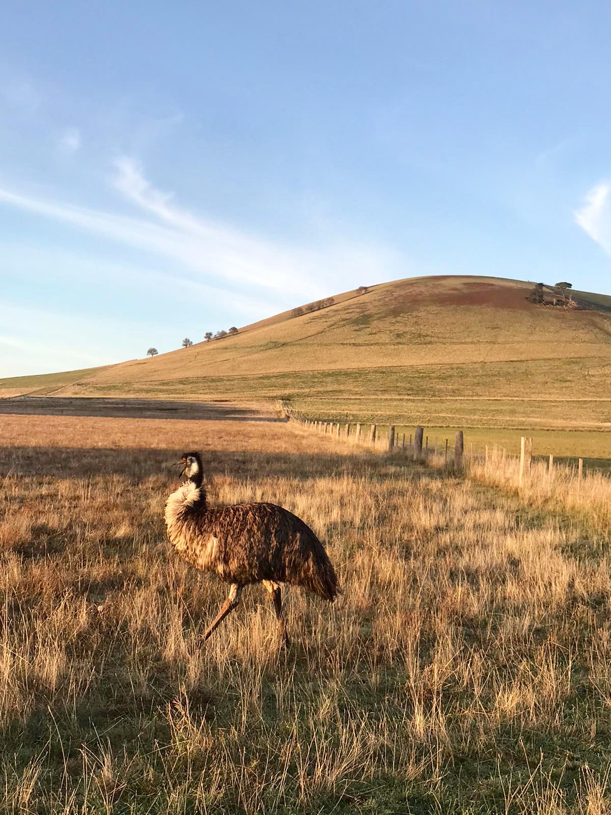
Forest Hill / Lityarang just south of my home in Kingston (not one of the Six Peaks, with a captive Emu)

3 thoughts on “Six Peaks Speak”