

Beyond Contact
‘Reading the Country at Contact’ NAIDOC Week 2019 Hepburn Shire self drive or bike ride tour: see https://visithepburnshire.com.au/reconciliation-week-2019-self-drive/
NOTE: The 2020 Reconciliation Week Tour was filmed and posted on YouTube in three videos because of the COVID-19 Pandemic. The virtual tour included three sites: Merin Merin wetland Mount Greenock near Talbot and the Neereman Aboriginal Protectorate site on the Loddon River north of Baringhup.
Barry Golding, last updated 22 August 2022
My intention in calling this page ‘Beyond Contact’ is to start make connections between ‘contact’ between Dja Dja Wurrung people in the landscape and the community within the Hepburn Shire that I now call home. Most of the latter part of the narrative is about what happened in the first three decades of contact between Dja Dja Wurrung people and the invading, mainly British ‘explorers’, squatters, ex-convicts and economic refugees.
- Part A is something of an autoethnography, exploring and reflecting on my experiences of ‘Living in a Dja Dja Wurrung landscape’.
- Part B explores ‘The way the land shapes people and place’.
- Part C explores a wide range of aspects of ‘Early contact in the Upper Loddon Catchment ‘.
- Part D: ‘Sites in the landscape in 2019’.
- Part E provides a short list of Useful References
The whole account is now over 32,000 words. I anticipate most people will just read the bits they are most interested in. Please enjoy and learn as I have done by researching and writing this.
Part A: ‘Living in a Dja Dja Wurrung landscape’.
Context
I have been motivated to write these notes about Aboriginal history in southern Dja Dja Wurrung country in the context of my involvement in the Hepburn Shire Reconciliation Plan (RAP) since 2018 as one member of the Community Reference Committee overseeing its creation and implementation. The original ‘Reflect Reconciliation Action Plan, July 2018-July 2019‘ was launched in the Mt Franklin / Larni barramul crater with a ‘Welcome to Country’ and Tanderrum (‘Smoking Ceremony’) conducted by Elder Uncle Ricky Nelson on Thursday 26 July 2018. One important part of the RAP involves improving and disseminating knowledge and insights about our generally poorly known and understood shared local history. These notes were begun with that purpose in mind, but have grown with time.
I understand that this is a work in progres. My notes are far too long to be an accessible summary. They now go well beyond the work or interest areas of the Hepburn RAP and its implementation process. Rather, I see them as a base document that I needed to ‘get sorted in my head’ and into the public domain for critical comment’.
They are derived from the huge pile of records I have collected and researched beyond the scope of my previous day job for decades. In this form, the notes can be progressively edited, added to or subtracted from and/or distilled with others or by others.
As a person in my seventh decade I am always concerned when people accumulate incredibly valuable insights and knowledge over a lifetime … and unexpectedly ‘go under a bus’ without an opportunity to share it with others. We will all go under a bus sometime …
I invite comment and criticism about what is wrong, misleading, inappropriate or missing in this account via email: b.golding@federation.edu.au. I figure it’s better to put this, my own story out now (last updated August 2022) for public comment and perusal rather than wait until it is complete and perfect. Some of these stories come from my own experience. Others have been preserved in documents that have been lost or inaccessible for 180 years.
Some of my early ideas about developing an interest in Aboriginal connections to Country that sit on the front of this document I originally presented in a paper called ‘The Great Dividing Trail and its associations with Djadjawurrung country’ at the ‘Black Gold’ Conference in Castlemaine in 23 October 2004. I have created a separate, fully revised version of that paper in May 2018 called ‘Reflections on a Lifetime in Dja Dja Wurrung Country’ posted in a separate blog.
I have lived most of my life in the footprint of Dja Dja Wurrung country. For almost four decades my paid work, academic writing and research in the field of adult learning took place while living at Kingston in the current Hepburn Shire. Whilst surrounded at home by fascinating communities, people and places, my other work has previously prevented me from working through and writing something integrative using the material I have collected. In 2018 in retirement from paid work, I found myself with the luxury, time and space to undertake field work, visit the State Library and State Archives in Melbourne, think and write to satisfy my own curiosity for a hopefully useful, local and community purpose.
For my historical narrative about what happened before 1839, I have used a wide range of sources, mainly organised around the life and times of Dja Dja Wurrung people, John Hepburn (an early squatter from 1838) and other early overlanders in southern Dja Dja Wurrung country. Post 1839, I have used Chief Aboriginal Protector George Augustus Robinson’s fully transcribed diaries between 1839 and 1850 to serve as an anchor for much of the historical narrative. Robinson had frequent contact with Loddon District Protector, E. S. Parker in Melbourne and visited the Loddon Protectorate station many times. He also met and visited Hepburn several times.
I do understand there might be several good reasons for not using Robinson as a source. Because Robinson never anticipated or intended his diaries to be published in full, he is often arrogant, self-serving, very frank (and sometimes rude and abrasive) in his opinions and experiences of people and colonial bureaucracies. Robinson did not have the skills or training to undertake the huge task he set for himself: of systematically documenting everything he observed and everyone he met. Diverse thoughts and occurrences are often recorded in the one diary entry.
While Robinson does not get everything right every time, and his dishonesty and duplicity is well known, he was in more unique places in Aboriginal communities and landscapes at important, very early times than any other observer in Van Diemen’s Land (VDL: present day Tasmania) and the Port Phillip Colony (present day Victoria).
His documentation, in intimate detail, of contact between Aboriginal peoples and cultures and his own invading people and cultures is sometimes the best (or only) first hand evidence we have to begin to understand the dynamics and complexity of the very early contact period. On many of these same topics, the invading settler and colonial authorities were typically evasive or silent. These events and people Robinson records are not just history. They shaped our people and our nation in ways we are still only discovering.
In writing as an older non-Indigenous male born in 1950, I am acutely aware not to make claims about current or past Indigenous (or Dja Dja Wurrung) traditional knowledge. What I am writing about is a shared history beyond contact, including my own knowledge, reading, research and life experience. I acknowledge that there are very few Aboriginal voices (or women) in this or other written historical records, but am delighted these voices are becoming more numerous and louder in other published work.
A reading of Robinson’s huge collection of fully transcribed journals and papers in VDL (Tasmania), edited by N. J. B. Plomley, first published as Friendly Mission in 1966, later critically analysed in a series of Essays in Reading Robinson (2008, edited by A. Johnston and M. Rolls) is a good introduction to Robinson’s considerable strengths and many weaknesses. Whether you like or hate him, Robinson’s journals, buttressed locally by other sources, arguably provide some important significant detail for Aboriginal people seeking to reclaim and rebuild heritage, identity, dignity, language, and pride, including in southern Dja Dja Wurrung country and the current Hepburn Shire.
My particular, personal interest is in the very early contact period between 1836 and 1842, during which so much happened in terms of the complex interactions between the large number of Dja Dja Wurrung people living in the landscape, and the relatively small number of invaders and pastoral stations, when so little about what was happening or changing was recorded: other than through the eyes and records of the explorers or Protectors. In these notes, I have deliberately left out much of the fascinating detail in Robinson’s diary in the three weeks between 7 to 28 February 1840, when he and Parker undertook reconnaissance in the area in and beyond John Hepburn’s station near what Robinson recorded as Korertanger (Kooroocheang), not because it is unimportant, but because is so interesting and important. As a pre-Protectorate account, it needs to be carefully teased out, mapped and interpreted separately. The document will eventually appear in will be called Reading Robinson and Parker visiting Hepburn, February 1840.
Meantime, I recommend trying to get access to a copy of Riding with Robinson, comprising the edited and annotated field journals of G. A. Robinson, between 9 January 1840 and 11 March 1840, self published in limited edition by Gary Presland in 2022.
Background to my developing interest in Aboriginal connections to country
My early life and acknowledgment of Aboriginal connections in the Donald district
I was born in 1950 at the Donald Bush Nursing Hospital, on the eastern bank of the Richardson River, which I now know is within and close to the north western edge of Dja Dja Wurrung country, that extends as far north to Lake Buloke to Boort and Pyramid Hill, and south to the Great Dividing Range. For almost 60 years my home has been within Dja Dja Wurrung country: in Donald before 1967, in Daylesford and Kooroocheang in the 1970s and in Kingston since the 1980s, living for a total of over 40 years within the now Hepburn Shire.
My paternal grandfather, Walter James Golding, was born on the St Arnaud goldfields. His father, my great grandfather, William Golding, a former miner at the Lord Nelson mine, is quoted in the St Arnaud Mercury (May 23, 1933), then in his 70s, recalling Aboriginal corroborees on Peter’s Diggings (now Carrapooe) south of St Arnaud, on what was Dja Dja Wurrung country during the 1870s. The now cringeworthy and patronising article includes that:
[Mr Golding] once saw a blackfellows’ corroboree near the [current St Arnaud High School, when it was ‘nothing but bush’] and they made a fearful din, beating tins and shouting “Yarrara, Yarrara Woop”. King Billy of Banyenong and his dusky Queen Mary, he frequently saw. No monarch stalked abroad with greater kingly dignity than King Billy. The insignia of his royalty was a piece of tin hung around his neck bearing the title of “King”.
My paternal grandmother was Amelia Pearse. The Pearse ancestors originally came from Devon in England and bought land around Donald at nearby ‘Devon Park’, on what was also Dja Dja Wurrung country. I have possession of a cup that was awarded to one of the Pearse ancestors for the best crop on ‘black land’, referring to the black, humus rich soils developed on relatively fertile, grey box country, as distinct from the ‘red land’ found on the sandier rises. The Pearse family regularly found Aboriginal stone implements including grinding stones and greenstone axes in wheat paddocks that had been turned over by the plough.
It was common in the 1960s for farming families in the Wimmera to have a collection of these stones on the tank stand outside the back door. Given there is very little bedrock in the area, they were relatively easy to spot, as most have been brought from considerable distances, including the ground edge greenstone stone axes from Mount William near Heathcote and quartzite grindstones and hammer stones, perhaps from the Heathcote area.
When I lived in Donald there was almost no knowledge or acknowledgement of Aboriginal Nations, clans or the histories and stories of present day Victorian Aboriginal people, aside from the patronising stories about Aboriginal ‘Kings’ and ‘Queens’, often wrongly suggestive of them being ‘the last of their tribe’. This trend started centuries ago as part of the exterminating act. The Aborigines of Victoria : With notes relating to the habits of the natives of other parts of Australia and Tasmania compiled from various sources for the Government of Victoria by R. Brough Smyth in 1878 is a good example. Almost all of the sources of information in Smyth 150 years ago are from colonial explorers and researchers, with no mention aside from a bald census, that Aboriginal peoples, though then decimated, had any contemporary voice or cultural knowledge.
The story of Donald in Shanty at the bridge (C. E. Sayers, 1963) is a good example of how local history was then constructed, around a narrative that starts with Major Mitchell in 1836 and ignores or carefully skirts around anything Aboriginal, always in lower case ‘aboriginal’. Aborigines are first mentioned in Chapter 3 (Sayers, 1963, p.31) in less than one page in total, mostly in a patronising fashion about the local ‘Kings’ with their brass plates. The double negative in the quote from Sayers that follows makes the ‘disturbance’ caused by the early squatters sound so benign, and deals with the First Australians and the wildlife in the same sentence.
‘The first of the Richardson squatters disturbed both the aborigines and the wildlife of the district. Most of them were not unkind to the aboriginal people. Gave them rations, employed them where they could be employed ….’
Fortunately, some of this ignorance and indifference has changed. In 1990, Ian D. Clark published the first definitive account of Aboriginal languages and clans: An historical atlas of Western and Central Victoria. It used historical records to create a fascinating, evidence-based picture of pre-contact Nations and Clans with clearly delineated territories. By June 2006, a 51 page booklet had been produced of Historical accounts of the Aboriginal people in the Buloke Shire, Victoria by the National Native Title Tribunal that help paint new and quite different pictures from the ones I had access to as a child in Donald. The most accurate, evidence based, contemporary source of information about the social and material culture of the Dja Dja Wurrung pre contact is found in Haw and Munro’s (2010) Footprints across the Loddon Plains. Paul Haw is based in Boort, has an intimate knowledge and passion and his book is an excellent read.
My late parents, Jack and Joan Golding were active local Donald History and Natural History Group members, so I went on excursions to see remnant native vegetation, settler homesteads and ruins as well as evidence of former Aboriginal settlement. There were almost no Aboriginal people in the Donald district during my childhood. Most local histories concentrated on the first white settlers and used the very benign term ‘settlement’ for the original act of dispossession.
In Donald’s case, the popular history suggest that it all started from a grog shanty on the Richardson River in 1863. There were some early photos of a local Aboriginal man, ‘King Johnny’ with a brass plate around his neck. I recall an Aboriginal railway worker in Donald called Teddy Warburton during the 1960s, and there were two teenage female Aboriginal swimmers from St Arnaud in the same decade who competed in local swimming competitions who I knew nothing else about.
The first Aboriginal people I recall seeing in a group in public was when I was perhaps ten years old in 1960. They were living in shanties near Moama on the NSW side of the Murray River opposite Echuca in Victoria. I now know that these were likely descendants of mainly Yorta Yorta people who had walked off the former Cummeragunja Mission (1881-1939). There were family photos of my great grandfather taking a very early car trip in the 1930s to outback central Australia as far north as Katherine in the Northern Territory. The boomerangs and digging sticks they presumably bought from Aboriginal people along the way were stored with what became my small collection of local Aboriginal stone implements that I picked up or was given.
I have since learned that everything should be left in place. In those days I was unaware that it was neither ethical not useful to take away lithic (stone) material from Aboriginal sites, in the process losing provenance. In the summer time I would ride my bicycle or walk, scouring the sandy ridges for stone scatter sites. When I went on summer holidays as a teenager I came to recognise and notice shell middens above most rocky headlands and shore platforms around Frankston, Pont Lonsdale, Lorne and Warrnambool. When I visited my uncle in Mildura, huge shell middens were also obvious along the banks of the Murray River. I came to understand that wherever I went, there was evidence that this country was occupied relatively recently. No one seemed to acknowledge or talk about what actually happened to the First Australians in the landscape, as if it was all prehistory and as if no Aboriginal people with local connections survived or existed. This was the era of ‘hunting and collecting’.
I also trapped rabbits within cycling distance of Donald, and became aware of the close association between rabbit warrens and what farmers called ‘Abo ovens’ or ‘middens’, now called ‘Aboriginal oven mounds’.
These large, elevated circular cooking mounds, comprehensively described in Haw and Munro (pp.9-11, with illustrative photographs about their operation on pp.12-13) typically had cricket ball-sized fireclay balls within them, and stood out clearly above the plains around Donald with their relatively dark, organic soil, at least until they were extensively ploughed over. Some of the apparently older ovens were bleached of much of their carbon and just had the clay balls eroding out, some of which were the size of small footballs.
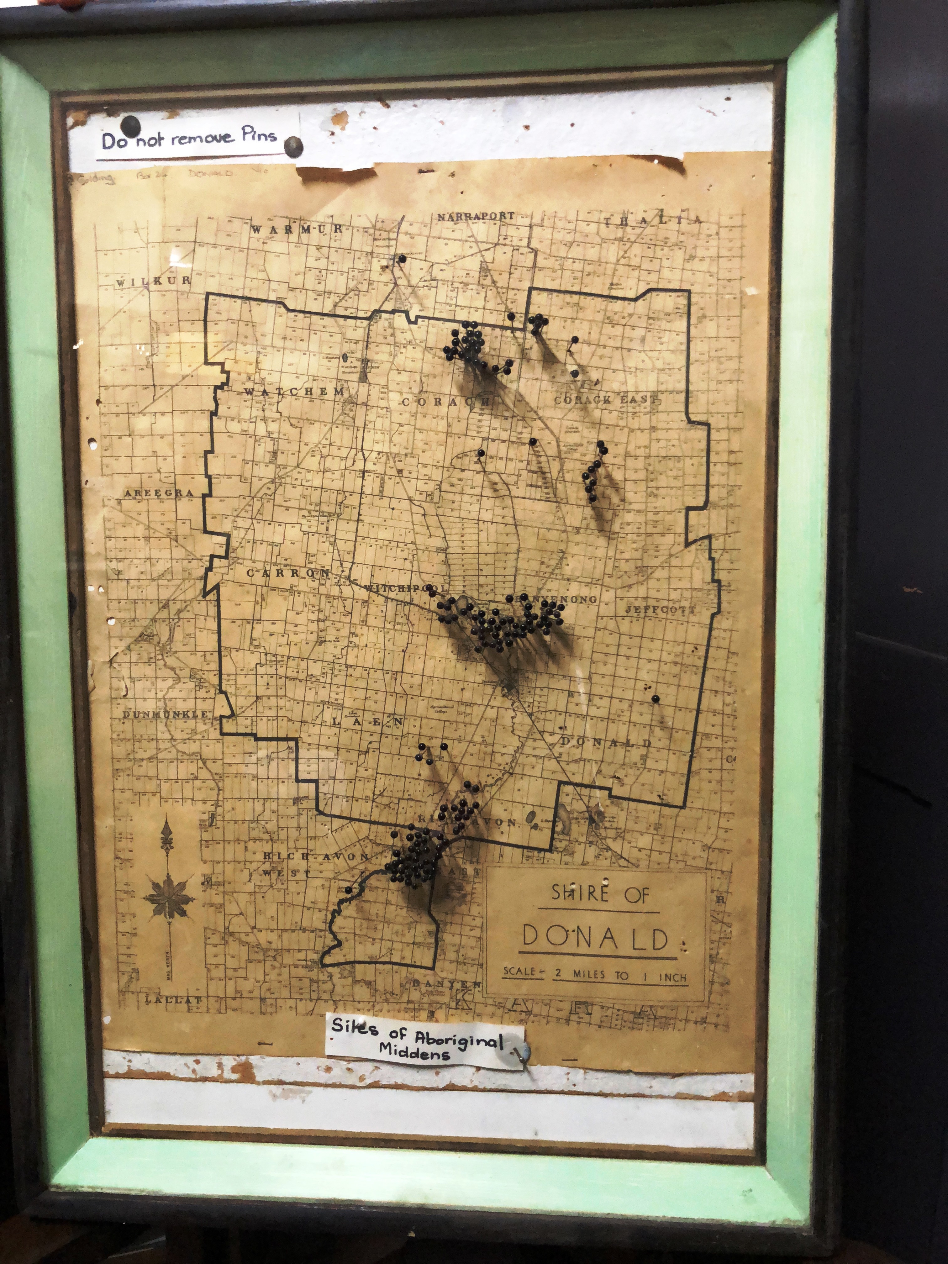
My parents owned a Donald hardware store, and after school I would hang around the shop and ask farmers in the shop whether they had any Aboriginal ovens on their property. If they said they didn’t, I would ask them where they had rabbits to help locate new sites. By the age of 16 I had ridden my bike or been driven by farmers to map over 160 Aboriginal oven mounds within the then Shire of Donald. The photograph below of the map, last added to in the late 1960s and now in the Donald History and Natural History Museum, was taken by Ann Dunstan in June 2018. The map identifies three main concentrations of ovens: towards the north of Lake Buloke around Corack, often on or between elevated lunettes; towards the south of Lake Buloke immediately north of Donald, and along the Richardson River at Richavon.
It is important here to note that the clay balls characteristic of ovens in northern Dja Dja Wurrung country and used as heat beads are missing wherever local rock, typically basalt is available, including in most areas in sothern Dja Dja Wurrung country. Good examples of these southern ovens are found in the Kooroocheang, Campbelltown and Werona areas north west of Daylesford, as well as south of the Great Dividing Range in Wada Wurrung country around Ballan and Fiskville. Given their location in relatively fertile positions in the landscape, almost all oven mounds are now on private land. Many are disturbed or partially destroyed by ploughing or rock removal, and all have been dug over by rabbits.
None of this was known to me or taught at school. Indeed I remember sitting in front of the class in the science room at Donald High School and looking at Aboriginal bones and skulls in cabinets that had been shamelessly recovered from a local sand quarry on the edge of Lake Buloke and displayed for all to see. In my Year 10 art class, I drew the archetypal Aborigine on one leg on a rock in central Australia with a spear. That was shamefully my sum knowledge of Aboriginal history to the 1960s.
A clear pattern began to emerge for me during my early teens in terms of where the Aboriginal oven mounds were that I had mapped with another local teenager, Doug Russell, whose property was then on the south of Little Lake Buloke. The ovens marked with black dressmaking pins on the large Shire of Donald Parish Plan above were still evident across the Shire of Donald landscape only 100 years after pastoral and agricultural invasion. They were seldom in open country, but more likely adjacent to swamps and watercourses or in association with lunettes. They were seldom right on water but on rising ground away from it. Very likely because they would have required wood, they were never far from former woodlands.
When they were on a swamp they were seldom far from an elevated nearby sandy ridge or lunette. These crescent shaped sand and clay dunes formed on the eastern, downwind side of many such lakes across north western Victoria. Many also have a stone scatter debris site on the lunette ridge where small tools have been manufactured. Those ovens that were most bleached I found on now stranded multiple lunettes, that I came to understand marked previous successive lake edges. For example when terminal Lake Buloke was much larger and fluctuating during recent interglacial periods, at times when the climate was wetter or drier. This made the likely age of some of the oven mounds very old.
When each the 160 ovens were mapped, it was evident that the distribution was far from random. From what I now know about Aboriginal national boundaries, the ovens we mapped tended to be close to but not right on the boundaries of the north west part of the Dja Dja Wurrung nation, the eastern part of the Jardwadjali nation and the southern part of the eastern Wergaia nation. Presumably when Lake Buloke was full, this was a land of plenty.
Joining the many dots, and tapping into my later Masters degree knowledge of Environmental Science a decade later, it seems that on both a local and large scale, the oven mounds I mapped tend to be ecotonal in terms of their ecological location: that is in a transition area between two biomes, where two or more ecological communities meet and integrate. In essence, ecotones maximize nearby ecological and food variety.
The Aldo Massola connection
A chance meeting with a National Museum of Victoria anthropologist passing through Donald in the early 1960s during my early teenage years provided me with some much needed historical and technological knowledge about the Victorian Aboriginal people behind the stone artefacts and oven mounds in the landscape. My father had a habit of finding out about everybody new who passed through my families [W. J. Golding and Co.] hardware store in Donald. I can’t recall whether Aldo Massola, employed as an anthropologist by the National Museum of Victoria until 1965, was initially quizzed by my father, or whether Aldo had come into the shop because he had heard on the local history ‘grapevine’ about our map of Aboriginal ovens.
I do recall Aldo was so interested in our map that on several occasions he came to our house for dinner on one of his many field trips. The entry on Aldo Massola in the Australian Dictionary of Biography talks a lot about his work life, including his many decades as a top waiter in Italian restaurants in Melbourne and his later career as an anthropologist and numismatist. However the sentence that summarises what I remember most as a teenager was ‘His friendly, confident manner and loving knowledge of wines …’. My father Jack Golding was a teetotaller. When anyone asked how my father was, he invariably responded, ‘A man who never drinks is always well.’ No one before Aldo had ever brought alcohol into our family home aside from the sherry reserved specifically for Christmas cakes. After a quick family conference, my parents deemed it impolite to ask Aldo not to bring a bottle of red wine in from his car boot. So each time he visited, Aldo drank the whole bottle over dinner himself, and took the bottle home so even the garbage man would not know what shameful event had transpired at our house, 9 Napier Street, Donald.
Aldo Massola undertook some early and important work exploring Aboriginal Victoria long before it was fashionable. However he was dismissed by the Museum in public disgrace in January 1965 for the theft of some rare museum coins. According to the sympathetic stipendiary magistrate, Massola was ‘an obsessed collector rather than a thief in the ordinary sense’. Massola’s work, as the Australian Dictionary of Biography (ADB) notes, ‘typified the rising amateur interest in Aboriginal society before the advent of university professionalism’. Before Massola’s work from 1955, Victorian Aborigines were virtually ignored. As ADB put it:
Massola visited many communities, won their respect and collected information. He assembled oral, written and pictorial material, and published a dozen books or bibliographies on Aboriginal subjects. Despite their lack of documentation and [academic] rigour, they demonstrated the research potential and remain significant for Aboriginal Victorians.
Massola’s (1968) book, Journey to Aboriginal Victoria is typical of his work, rich in tantalising local descriptions of Aboriginal sites and Aboriginal history across Victoria, but totally missing references or acknowledging original informants or data sources. On page 95 he clearly refers to our oven mound mapping work, without acknowledgment, when he describes the concentration of ovens along the Richardson River and Lake Buloke. His early work taught me several important lessons, critically important as an academic for my last 25 years in paid employment.
The first is to try, as Massola did, to be accessible to non-academic stakeholders and to tell a good and accessible story. The second lesson, that Massola did not practice, is to properly identify and acknowledge sources. A third lesson, that is important in relation to sensitive sites and cultural protocols, but was missing in Massola’s and most others working in archaeology pre 1970, is to acknowledge that not all sites can or should be known by or accessible to all members of the public, and that local Aboriginal people and Nations today as traditional owners have rights to a voice in the present as well as in a telling of their past. The fourth lesson is to leave everything as you find it. Massola was not only an avid collector. He also directed others to sites where they were encouraged to also collect,
My interest in rocks came from my grandfather Walter Golding, himself the son of St Arnaud gold miner in the Lord Nelson Mine. Walter’s grandfather William as well as his father William junior had worked on the Peters Diggings (now Carapooee), and later at Dunolly and Lamplough. My interest in landforms (geomorphology) came from my struggle to understand what happened before and after contact in the Wimmera landscape to the First Australians.
Until my 20s I was particularly interested in the relation between the pre-contact vegetation, the lakes and river systems, the lunettes and the Aboriginal oven mounds in the then Donald Shire (now part of Buloke Shire). This interest became the subject of an unpublished Advanced Geomorphology project as part of my Geology (Honours) degree.
From my 20s I began to be more interested in ecological and environmental relationships, specifically hollow dependent animals and birds in the Wombat Forest around Daylesford, which became the subject of my Masters Degree in Environmental Science at Monash University. It was only during my 30s and 40s that I discovered people and ideas through a Bachelor of Arts (undertaken for sheer pleasure, with a major in philosophy of science and feminism), and by the age of 50, a PhD focusing on two way movement and articulation (credit transfer) between the TAFE (Technical and Further Education) and higher education interface.
Aldo Massola is an example of what I have learned many times throughout my very diverse academic life: that it was possible, and sometimes very valuable and insightful, to come into an academic field as a naive (albeit well educated) outsider, and become an Australian or international expert in another field without necessarily following a linear path.
Unsurprisingly these rich, very early experiences of the value of field work led me to undertake my first degree in geology with geomorphology and mining sub majors, and later a Masters degree in environmental science, all with significant field work. My Geology Honours project involved mapping the sedimentary rocks in the Walhalla Moondarra area of Gippsland.
Even my work in adult education post my PhD in education has gravitated towards insights from people in the field, increasingly towards people’s stories of often complex lived experiences in place, rather than about bald and bland historical facts. In many ways, my interest in narrative, including writing this auto ethnographic account, and digging deeper into settler, Aboriginal and government interactions at contact wherever I am in Australia, in this case in the Hepburn Shire, is all part of a quest for me to make sense of a convenient fiction: that this land and its first people was or is ‘settled’. Indeed I have come to regard much of what happened within Australia in the absence of a Treaty as ‘unsettled’.
My contention is that in the absence of national reconciliation with First Australians in the form of a negotiated Treaty, that the questions that the nature of settlement raises have not been properly answered or satisfactorily resolved, at least to 2022. When I recently contacted an academic colleague in Aotearoa New Zealand, he asked me what I was writing about. I was ashamed to admit that we in Australia are still trying to work out and resolve what happened here in 1840, and are around two decades into a national Indigenous reconciliation process that might lead perhaps to some form of national treaty perhaps 200 years after the New Zealand Treaty of Waitangi in 1840. Meantime, the Victorian Government has recently set up a Victorian Treaty Advancement Commission that is now working steadily towards an Aboriginal led Treaty in the state of Victoria.
The year New Zealand established their treaty, 1840, was the same year our forebears were setting up Aboriginal ‘Protectorates’ in the Colony of Port Phillip, to deliberately isolate and concentrate First Nation refugees then being violently displaced by White invaders, and being ‘taken up’ by our ancestors, totally deprived of their own lands to be Christianised and civilised. I am doubly ashamed as an Australian that 21 years after the Tampa refugee crisis (in 2001), thousands of modern refugees who have fled to Australia are still imprisoned indefinitely without trial for much the same reasons, in similarly brutal and inhumane conditions.
My experiences in the 1970s of Aboriginal Australia through music and song
My first deep immersion in a comprehensively peopled Aboriginal landscape was my brief stint as a student geologist around 1970, undertaking field exploration for the mining company CRA at the Dugald River lead-zinc mining prospect in NW Queensland. The drillers camp was based out of Cloncurry, at that time a very racially divided, outback mining town. In 1970, being home to the Mitakoodi, Kalkadoon and Pitta Pitta Aboriginal people from across the wider region, Cloncurry had a ‘black pub’ and several ‘white pubs’. In the 2016 census, one in five people in Cloncurry were Aboriginal. The drillers brought in from the Queensland coalfields in 1970 were a rough lot. They referred derogatorily to Aboriginal people as ‘coons’ and disturbingly to young women as ‘gin jockeys’. There was boastful talk, and I hope that was all it was, about drillers in the area using jackhammers to remove panels of ageless Aboriginal rock art.
I became aware of the past and present Aboriginal connections through the name of the ‘Kalkadoon Hotel’ in nearby Kajabbi. The Kalkadoons (properly Kalkatungu Nation) traditional lands are in the Mount Isa region of Queensland. The Kalkatunga Nation has been called ‘the elite of the Aboriginal warriors of Queensland’. In 1884 they were massacred at “Battle Mountain” by settlers and mounted Native Police based in Cloncurry after years of guerrilla resistance. The estimated numbers of Kalkatunga brutally hunted down and killed in only six years, from 1878 to 1884, in counter-attacking incursions and the exercise of pastoral expropriation over their lands runs to around 900.
Soon after I completed my geology degree, my part time work as a ‘folk musician’ in ‘Mulga Bill’s Bicycle Band’ became my full time job in 1972. Indeed we were the first Australian ‘folk’ band to become full time professional touring musicians, a year or two before the ‘Bushwhackers’ did similarly. For four years our seven-person band toured extensively and played in all cities and most rural towns in all Australian states as well as the Northern Territory (see my ‘Mulga Bill’s Bicycle Band’ web page). Our band ‘rode the wave’ of the 1970s folk revival and the mid-1970s Whitlam inspired nationalism, playing Anglo-Irish inspired colonial era songs about convicts, bushrangers, drovers, shearers and overlanders.
In retrospect, much of what we did and sang about was cringeworthy. At worst it was jingoistic, racist and sexist. Some of the humour was lavatorial. Most of our extensive touring was for concerts organised by local branches of State Arts Councils. We were often billeted with local people, though some of our concert gigs involved touring independently in our own bus we fitted with a kitchen and eight bunks. Wherever we went we read widely about local history. We tried to make sense of the complex and often contested past and the uncomfortable present that we encountered in the hundreds of Australian rural communities we sang and performed in, by digging back into this history to try and introduce and meaningfully embed what we saw and heard into our otherwise colonial era songs. Whilst it was enjoyable and enervating personally to take ‘songs home’, it was also illuminating and increasingly fraudulent and disquieting to me personally on a number of levels.
We became aware of the strong desire during the 1970s for most communities we visited as touring musicians, to want the Aboriginal past and present to be out of sight and out of mind. It was easy and convenient in more ‘settled areas’ on coastal south eastern Australia to imagine that it all started with convicts, bushrangers, overlanders, gold diggers and bullockies, as there was very little evidence of black histories (or an Aboriginal or Torres Strait Islander present) in the local museums, communities or monuments.
It was very different in many areas of central, western and northern Australia, where Aboriginal and Torres Strait Islander people, communities, language and history and present were often very much alive, but hidden behind the same, very raw and typically racist, sexist and jingoistic, colonial package. As an example, when our band arrived in the Cape York mining town of Weipa to play, the concert organisers from the mining company put up a huge hessian screen behind the white audience in the outside venue, in their words, in order to ‘keep the darkies out’. There were signs in the Coonamble RSL in outback New South Wales that Aborigines were not allowed inside the building: thankfully we did not have to play there. In other places, the racism was more covert. In some Queensland hotels, the pool table cues were sometimes kept behind the bar to keep them out of the hands of ‘the darkies’.
My most shameful ‘Aha’ moment came in the early 1970s when our band played at the remote Aboriginal community of Yuendumu north west of Alice Springs. I found myself introducing ‘traditional Australian folk songs and dances’ to Walpiri people very recently lured off their land, who retained most of their own songs, dances traditions and language. It was the first place in Australia where I felt I was totally ignorant and out of place as an Australian, and that I acknowledged we as a band were totally out of our depth. Jan Wozitsky from the Bushwackers Band has talked about very similar experiences in the same era during the 1970s.
Our band took small steps to try and broaden our musical offerings to include Aboriginal and multicultural music and themes. But in both pub and small, conservative rural town settings in Australia, the audiences tended to want to be comforted by the safe familiarity of the rollicking ‘Ryebuck Shearer’ rather than being discomforted by our haunting rendition of ‘Cloncurry’, based on the Kalkadoon Aboriginal massacre story. In 1974 the Australian (Whitlam) government unexpectedly chose our band to be ‘Australia’s folklore representatives’ at the Finals of the Football World Cup in Frankfurt, then in West Germany, as Australia was represented.
Whilst this was an incredible experience to be immersed in showcasing Australian ‘culture’alongside 15 diverse other world nations and folklore representatives, live on TV to billions of viewers at the Opening Concert, it highlighted how relatively shallow and recent our Anglo-Irish colonial songs and tunes were, in comparison with the rich and deeply embedded folkloric offerings from European, South American, Asian and African nations – as well as the Glasgow City Pipe Band representing Scotland. It would not be possible or desirable for a similar folkloric choice to be made by and for Australia in 2022, given slow but recent advances towards Aboriginal and Torres Strait Islander recognition and reconciliation on one hand, and acknowledgement of Australian multiculturalism on the other.
I recall trying desperatel, and unsuccessfully to answer the simple but uncomfortable question, posed to us by other national folklore groups in 1974 in Frankfurt, then West Germany: ‘What is your Australian culture?’ It is something I honestly knew almost nothing about.
Forty years living north of the Great Dividing Range in Victoria
I moved to the Daylesford area to live during the mid 1970s when the band days were almost over. I initially moved into an abandoned house on the Moolort Plains between Newstead and Maryborough. The deal with the local trusting farmer, John Bryant, was that I could live there if I was able to convince the sheep then walking through the open doors to move out. It is ironic that around 40 years later I still researching and writing about what actually happened on these same plains and wetlands, focusing on the early contact period between 1836 and 1841.
As ‘Mulga Bill’ we got got sick of forever being on the road. The posters for our concerts said ‘live on stage’, but we were often feeling very drained and exhausted. We had sloshed around in the shallow waters of the colonial bush music revival and more recent Australian nationalism, but to me it felt increasingly like being trapped in a cultural lie and cul de sac.
Having lived on the flat and dry Donald plains before going away to school for Year 10 and then to university in Melbourne, I rightly sensed that the relatively fertile and well watered area I had moved to around Daylesford in central Victoria by 1976 would also have had a rich Aboriginal past.
In the past 40 years much new evidence and insights of that richness, including and increasingly from Aboriginal voices, have become available in southern Dja Dja Wurrung Country. All there was in the accessible literature in the 1970s were Edgar Morrison’s tantalising little booklets about the interactions between John Hepburn, the Aboriginal Protectors around Mount Franklin and what were then called ‘Jaara’ people, now Djarra or Dja Dja Wurrung. Edgar Morrison based much of his decade of research on careful examination of boxes of files in the Public Records Office in Melbourne that no one had ever bothered to look at before.
Edgar Morrison was in part politicised and motivated during the 1960 by his Christian faith and his understanding of the Methodist Church siding with Aboriginal people for the right not to be forcefully evicted for mining, as had recently occurred in the Weipa area of Cape York. The Government of Queensland had granted a mining lease to Comalco in 1957 and a special bauxite mining lease a year later. This was 60 years after the Weipa Presbyterian Mission outpost was established in 1898 and over 100 years since the Loddon Protectorate closed near Daylesford. The forceful dispossession from land and culture was happening all over again on other frontiers as had started almost 200 years before in 1788 in Sydney.
In strategic places around the former Loddon Aboriginal Protectorate, Morrison thoughtfully organised roadside signs and monuments to mark notable Protectorate sites he had identified to help guide later locals, visitors and historians. It was a rich legacy. It is notable that almost no new signs have been added to 2022. Morrison understood that something important and momentous, largely unspoken, had happened here in this rich landscape in the catchment of the Upper Loddon River at and after contact. I now know that the first invasion of Dja Dja Wurrung country by overlanders (from Sydney) and over-straiters (from Van Diemens Land) quickened to a huge land grab from 1837.
Lucille Quinlan’s Here my home book about the life and times of squatter John Hepburn (published in 1967) came out around the same time as Edgar Morrison’s first booklet. It corroborated Morrison’s contention of the fascinating parallels (and some differences) in time and space between John Hepburn and Edward Parker’s life and times.
As a former geologist, I found that some of the geological maps in the Ballan and Werona areas had a symbol marked, ‘NO’ an acronym for for ‘Native Ovens’ still visible in the landscape in the 1920s. By 1977, the first early transcription by Gary Presland of some of Chief Aboriginal Protector George A. Robinson’s 1839-40 diaries provided compelling new evidence of what had happened here that hitherto had been unavailable or poorly documented. Whilst teaching at Daylesford Secondary College between 1985 and 1988, a number of my students were able to point to other sites in the landscape including Aboriginal oven mounds around Kooroocheang and Werona, and led me to people who owned or knew about those sites. The growing accessibility of Public Record Office Files also provided me with some new insights and evidence.
Not in my wildest dreams did I imagine that 40 years after I moved to the Daylesford area that an organisation such the Dja Dja Wurrung Clans Aboriginal Corporation would have become organised and empowered enough to begin to reclaim their own story history and unceded lands. As a local (Daylesford) activist Peter O’Meara put it recently, when recalling that his initial interest was sparked from a Creswick Landcare Centre tour he had undertaken with me in the early 1990s, ‘I could not imagine back then, that now we would be formulating a Hepburn Shire Reconciliation Plan and that Dja Dja Wurrung would be in the beginnings of becoming co-managers of the Hepburn Regional Park. I think these are remarkable times!’
My work as a teacher at Daylesford Secondary College included teaching elements of local history and geography that included local Aboriginal history. There was evidence amongst most local families and children of a combination of total ignorance (or denial) about what had happened in the Daylesford area at the time of contact, despite the fact that a significant colonial initiative, the Loddon Aboriginal Protectorate had been located just to the north of Daylesford (around present day Franklinford including Mount Franklin) for almost a decade (1841-48), before the much better understood local discovery of gold in many sites beginning in Clunes in 1851.
1988 was the year of the Australian Bicentenary, ‘celebrating’ the arrival of the first fleet of British convicts at Botany Bay. A significant minority of Australians, including me, were at best underwhelmed and at worst incredibly ashamed and angry that huge amounts of public money had been poured into the many shallow and jingoistic events associated with the Bicentenary year.
As a form of protest, at our house in Kingston, we got friend and former sign writer, Dave Allen, to create a sign to put on the former Creswick Shire Hall billboard on our home street front, with an Aboriginal flag and the words, ‘Australia was settled, named and cultured before 1788: Don’t celebrate’. Early that same year I bailed out of my secure, permanent profession of the previous decade teaching the increasingly rigid and conservative curriculum of secondary schools (in Ballarat, Humpty Doo in the Northern Territory and Daylesford), to apply for, and surprisingly be offered, the job of ‘Coordinator Aboriginal Programs’ at SMB TAFE in Ballarat.
On the day I started I had a baptism of fire: the local Aboriginal Cooperative in Ballarat understandably cried foul that a non-Aboriginal person (me) had been appointed to what they envisaged should have been an Aboriginal position. Since then I have come to understand and be respectful of such resistance, as well as to respect the Indigenous desire for cultural ownership and persistence.
There are inherent difficulties, tensions and contradictions when people, like myself who are not Aboriginal, work, write and theorise on Aboriginal topics about Aboriginal people past or present. This blog is no exception. My contention is that the research work is timely, important and valuable but has to be done off a solid evidence base and wherever possible, collaboratively and inclusive of local Aboriginal voice, knowledge and insights.
I worked hard for the two years I was in the position of Aboriginal Program Coordinator in Ballarat to understand and get positively beyond this ‘lumpy’ start and establish trust with the mostly mature-aged Aboriginal students and the Ballarat Aboriginal community, and most importantly, to maximise Aboriginal ownership and involvement in the programs across the region and do myself out of a job. SMB was encouraged to fly the Aboriginal flag in 1989 alongside the Australian flag, something that the relatively conservative Ballarat community (wrongly) thought risked having ‘the sky fall in’. Thankfully the idea and practice has become widespread nationally and acceptably celebratory, as have ‘Welcomes to’ and ‘Acknowledgements of’ Country.
My highlights in the SMB job included organising field excursions with local and regional Aboriginal students from several of the courses. This included field trips to western and north western Victoria. Several students in the accredited Aboriginal Welfare Studies course progressed through to completion, making sure that Aboriginal control and course content were not just superficial.
Following Edgar Morrison’s tracks
I am deeply indebted to the work and commitment of the late Edgar Morrison from Yandoit, whose research into the Loddon Protectorate was ground breaking for its time and provided me with useful leads to follow. Insights and information in Early Days in the Loddon Valley (1966), Frontier Life in the Loddon Protectorate (1967) and The Loddon Aborigines (1971) were for many decades the best and most accessible information we had to tell the story about what happened to Dja Dja Wurrung peoples post Major Mitchell’s 1836 two passes through their country. The descendants of the late Edgar and Joan Morrison, most recently son, Don Morrison, grandson, Robert and great grandson, Nick still farm in the Yandoit area on land that the Morrison’s settled in 1856. The family still pass on stories about going up to former Protector, E. S. Parker’s place at Franklinford in the 1850s.
To his credit, Edgar Morrison did acknowledge and value an Aboriginal present and voice, and made contact in the 1960s and 70s with then living descendants from the Loddon Protectorate during the 1860s, including with Thomas Dunolly’s (born 1854. Died 1923) daughter, Ivy Sampson (died in the 1980s). It was Morrison’s account of Thomas Dunolly in The Loddon Aborigines booklet, originally given to Harley Dunolly Lee’s late grandfather by his uncle, that became critically important in encouraging him to learn more about his Dja Dja Wurrung family and history, as elaborated in Hodgens (2014, pp.43-5). Harley’s Aunty Ivy Sampson planted the sheoak tree marking the original boundary of the Protectorate cemetery in 1968 during an event organised by Edgar Morrison. Morrison’s son, Don today continues this warm and positive association.
Dja Dja Wurrung people, voices and insights
With some exceptions, most historiography before the 1970s about Aboriginal people in Australia was by non-Aboriginal people using original government documents or diaries. In the five decades since the range and accessibility of resources available, including online and digitised via Trove, has greatly increased. When Edgar Morrison undertook the monumental research for his three booklets during the 1960s, he relied on going down to Melbourne on the train to a range of government repositories and sifting through boxes of poorly sorted or indexed documents, taking notes longhand without access to what is now taken for granted: accessing, copying, word processing, scanning or researching and corroborating information now readily available the internet.
The most notable change in local history telling is the way in which perspectives and also the voice of the Dja Dja Wurrung people have come to be respected, heard and acknowledged. The most notable example of this is Djuwima Djarra, published in 2014 based on stories, records and recollections of some of the estimated 2,000 Dja Dja Wurrung descendants and the small number of known apical ancestors when the total likely Dja Dja Wurrung population plunged to perhaps 20 people.
Whilst the work of John Tully, Dja Dja Wurrung language of Central Victoria (1997) has usefully made language and words more widely accessible, it is no longer appropriate two decades on, for a number of reasons, to claim, as Tully states in his acknowledgements, that his work ‘… is solely a product of historical research. I have met a number of people of part Djadja Wurrung descent but have found none that have preserved knowledge of the language’. First, with thousands of likely Dja Dja Wurrung descendants it is no longer possible or appropriate to write off a people or their language given the shameful ‘ legacy of a number of generations of children separated from their parents and a policy of disapproval of Aboriginal languages on missions and government stations’, as Tully notes in the sentence of acknowledgement that follows.
The term Tully uses suggesting ‘partial descent’ is particularly problematic. The official definition in Australia of Aboriginality is tripartite, requiring all three parts to be established for Aboriginality to be recognised: descent (the individual can prove that a parent is of Aboriginal or Torres Strait Islander descent); self-identification (the individual identifies as an Aboriginal or Torres Strait Islander); and community recognition (the individual is accepted as such by the Aboriginal or Torres Strait Islander community in which he/she lives). Aboriginality is not formally acknowledged unless all three are established. For many decades being defined as ‘part-Aboriginal’ gave authorities the legal right to remove children from their families. For all of these reasons. describing someone as ‘part Aboriginal’ and apportioning these ‘parts’ is now inappropriate and offensive.
Finally, the sources Tully draws on to produce his dictionary includes a wide range of sources of varying reliability. Whilst the dictionary is useful in that it was the best source available in 1997 (based heavily on the 700 Dja Dja Wurrung words in Joseph Parker’s (1831-1917) dictionary published in the 1860s, there are problems in the detail. Whist all Aboriginal words are matched to an English word and an original source, the English to Dja Dja Wurrung list includes no notes about sources.
Part B: The way the land shapes people and place
Before proceeding to a narrative focused on southern Dja Dja Wurrung country in the decade between 1836 and 1846, I provide a brief synthesis of several factors that have remained very similar pre and post contact, specifically the rocks, the rainfall and the runoff. All still shape people and place in the Loddon, Avoca and Richardson-Avon catchments .
The old bedrock. the intrusive granite and the young volcanic ‘icing’
I am unashamedly biased by my training and thinking in geology and geomorphology, towards ‘earth up’ and climatically mediated explanations of past and present human settlement patterns. These patterns clearly greatly influenced the pattern of Dja Dja Wurrung as well as present day settlement in the current footprint of the Hepburn Shire. In essence, there are three main rock types outcropping at the surface.
The first is the old (approximately 500 million year old) bedrock of tightly folded (Ordovician) shales and slates, where it is not covered by either relatively recent basalt (only a few million years old at most) or alluvium. This old rock with its quartz intrusions (often containing gold) develops very thin, often rocky and infertile soils. This elevated area was therefore typically forested in Aboriginal times, and reforested after 1910, when the Victorian government started to manage rather than unsustainably ravage trees as fuel and timber for mining.
The weathered, relatively young (at oldest, a few millions of years) basalt ‘icing’ that overlies these old rocks, by contrast, develops rich, typically red soils. When regularly burnt over hundreds of years by Aboriginal people, these rich volcanic plains supported very productive grasslands or woodlands. The volcanic grasslands and scoria cones that lie in the heart of Dja Dja Wurrung country supported some of the highest population densities of Aboriginal people per hectare anywhere in Australia, aside from in some rich coastal biomes.
The third main rock type is granite. It advanced from below during the Devonian period (36–420 million years), in places replacing the former Ordovician sediments, ofter baking the rim to create a weather-resistant metamorphic aureole. The granites around Harcourt that include elevated peaks including Mount Alexander, Mount Tarrengower and Mount Beckworth are good examples. Big Hill, south of Bendigo, Gough’s Range south west of Tarrengower) and Expedition Pass near Castlemaine are good examples of metamorphic aureoles exposed by weathering. Because the soil is typically less fertile on the peaks, most granite areas remain forested and in public ownership.
It was the rich, meticulously managed and regularly burned volcanic grasslands that Mitchell called Australia Felix (meaning ‘fortunate’ or ‘happy’ Australia in 1836 ) that were so attractive for sheep and cattle grazing for invading pastoralists. The richest country for grassland Aboriginal food economy required no other intervention by mainly European invaders than removing, killing or displacing the Indigenous inhabitants. Sites that were advantageously ecotonal (on the edge and accessible to a range of ecosystems) and strategically sited in terms of water and shelter for Aboriginal people were similarly advantageous for squatters and station homesteads, as well as for some pre-gold colonial towns.
The next phase of European land use settlement in Dja Dja Wurrung country from 1851 was very different, in that it mainly involved gold mining and many more people in the landscape, mostly conducted in the older ‘basement’ rocks under or around the elevated edges of the volcanic plains.
Gold was mined in three quite different situations were it had become concentrated by three different mechanisms. In some places the gold was richest where it was still embedded within the quartz reefs and veins that had intruded into the old shale and slate bedrock some 300 million years ago.
In other places, particularly under the volcanic plains, the gold was incredibly rich where alluvial gold had been buried in ‘Deep Leads’ by lava flows, trapped within the gravel beds of former river valleys. Elsewhere, such as in Castlemaine, alluvial gold was to be found concentrated close to the surface in the gravels and sands of present day watercourses and rivers. Mining for gold, mostly by Europeans but also by Chinese in all three situations between 1851 and 1900 accounts for the siting and development of most former ‘gold’ towns across Dja Dja Wurrung country. There is no doubt that gold, including as nuggets, would have been visible over millennia to Aboriginal people. Indeed kara kara, after which a Victorian County is now named, is likely the Aboriginal name for gold.
The Permian Glacials
Before leaving the rocks there are several important, necessary and useful additions to this ‘super simple’ picture of the old bedrock, the granite and the newer volcanic ‘icing’.
There are also several very small but important outcrops of Permian (250-300 million year) fluvio-glacials. In effect these are jumbled but fascinating collections of very diverse rocks plucked, ground up and dumped by an ancient huge ice sheet. These ‘Wild Duck Formation’ deposits outcrop in several isolated outcrops, including on a road cutting between Campbelltown and Sandon and well as at Green Hill north of Carisbrook.
The likely importance of these deposits to Dja Dja Wurrung people is that it gave them access to a range of rocks with excellent tool making properties (including Cambrian greenstone) not otherwise outcropping in their home range.
Rainfall and runoff
Aside from rock type, the main physical features that limited settlement and shaped land use both pre- and post-contact are rainfall and surface water availability. The key climatic variable across Dja Dja Wurrung country is the marked north-south gradation in rainfall. The highest rainfall areas (with coolest temperatures and greatest runoff) are in the high country (altitude up to around 750 metres above sea level) in the south, closest to the Great Dividing Range.
The lowest rainfall occurs in the flatter and lower country (down to around 100 metres above sea level) in the far north, where it is on average hotter, with higher evaporation and minimal runoff. From Trentham in the south to Boort in the north, a distance of around 200km, average annual rainfall drops from around 1,000mm to 400mm. Effectively, on average for every one kilometre one travels north, the average annual rainfall drops away by 3mm. In fact most of the drop off happens quicker and is closely related to altitude. As an illustration, the rainfall gradient in the interval of 30km between Daylesford and Newstead (only 30 km apart) drops off 13mm for every km one travels north.
The vegetation and therefore productivity of the land in Dja Dja Wurrung country is closely related to this south to north declining rainfall (and associated temperature and evaporation) gradient. The southern grasslands are on average much greener and supportive of summer plant growth than are the grasslands in the north, and the farming allotments and human population densities on grasslands in the south are today much larger and more productive. This is likely to also have been the case in Dja Dja Wurrung times.
From west to east, water flows north in the Richardson-Avon, Avoca, Loddon and Coliban Rivers. Whilst not all these rivers run every season or every year, there were sufficient wetlands, semi-permanent pools, lakes and billabongs associated with each of these rivers, their tributaries (and distributaries in the far north) and particularly on the volcanic plains, to support aquatic and riverine ecosystems that provided rich, diverse and relatively secure plant and animal resources for Dja Dja Wurung people pre-contact.
Recent changes caused by volcanoes
There is evidence elsewhere in Australia, including in parts of the Western District around Camperdown and Mount Gambier, that volcanoes were at times contemporaneous (happening at the same time) as Aboriginal settlement, as recently as 5,000 years before the present. Whilst Dja Dja Wurrung people would have seen and known about these volcanoes, there is as yet no firm datings or other evidence of any active vulcanism within Dja Dja Wurrung country, if one accepts approximately 60,000 years as an approximate human arrival time in Australia.
The extensive former volcanoes on the northern slopes of the Great Dividing Range in southern Dja Dja Wurrung country such as Mount Franklin and Mount Greenock were almost certainly not spewing lava 60,000 year ago, However it is not impossible that some of the volcanoes within the Hepburn Shire might have had smaller and very recent eruptions, gas vents or parasitic cones. The only scientifically dated evidence (albeit very limited) is that the main Mount Franklin crater may be up to 10 times as old (approximately 470,000 years) as Aboriginal settlement.
This does not mean that volcanoes, and particularly the lava flows associated with them, are not important in determining past and current habitation in the region. Basaltic lava flows downhill like honey, filling existing river valleys and creeks and in some cases flooding across extensive plains. The former, now buried rivers and creeks tend to be replaced by new streams that flow along the margin of the lava flows (lateral streams), and sometimes along both sides of the lava (twin lateral streams). Wherever narrow ribbons of lava have filled valleys in the older bedrock and created twin lateral streams, the basalt flows have tended to become convenient, relatively grassy Aboriginal and also modern roads and highways. In some cases new streams have developed on and across the lower parts of extensive sheets of lava. Middle Creek on the Moolort Plains is a good example.
These relatively young, new streams, particularly lateral streams like Joyce’s Creek, or the Loddon River (between Vaughan Springs and Newstead) that have basalt (former lava) on one side and forest on the other make for excellent places to live and travel along, now as then. In some cases, these relatively new valleys have also concentrated alluvial gold in them, meaning that pre-gold mining settlements such as Guildford and Lexton have also been subject to post-1850s alluvial mining settlement.
Maps are territories
For me, maps tell heaps. The following are copies of maps that I think have particular relevance to Dja Dja Wurrung settlement and the post-contact period. The maps referred to, several of which are reproduced from Bain Attwood’s A Good Country are included in this narrative, as in Attwood’s excellent definitive history of Dja Dja Wurrung country. to enhance the spatial understanding of the current historical narrative.
Dja Dja Wurrung Nation and Clans, (Map, see Attwood, 2017, p.2, after Clark & Cahir)
The Dja Dja Wurrung Aboriginal Nation in the map below comprised at least 24 clans whose home range was specific to particular locations or areas.

Most of the former volcanoes and associated lava flows were in southern Dja Dja Wurrung country, concentrated in a broad arc between Avoca and Kyneton. All but the southernmost craters and lava flows were grassland or woodland at the time of first contact in 1836.
Adjacent Aboriginal Nations and relationships (Map, see see Attwood, 2017, p.4, after Clark)
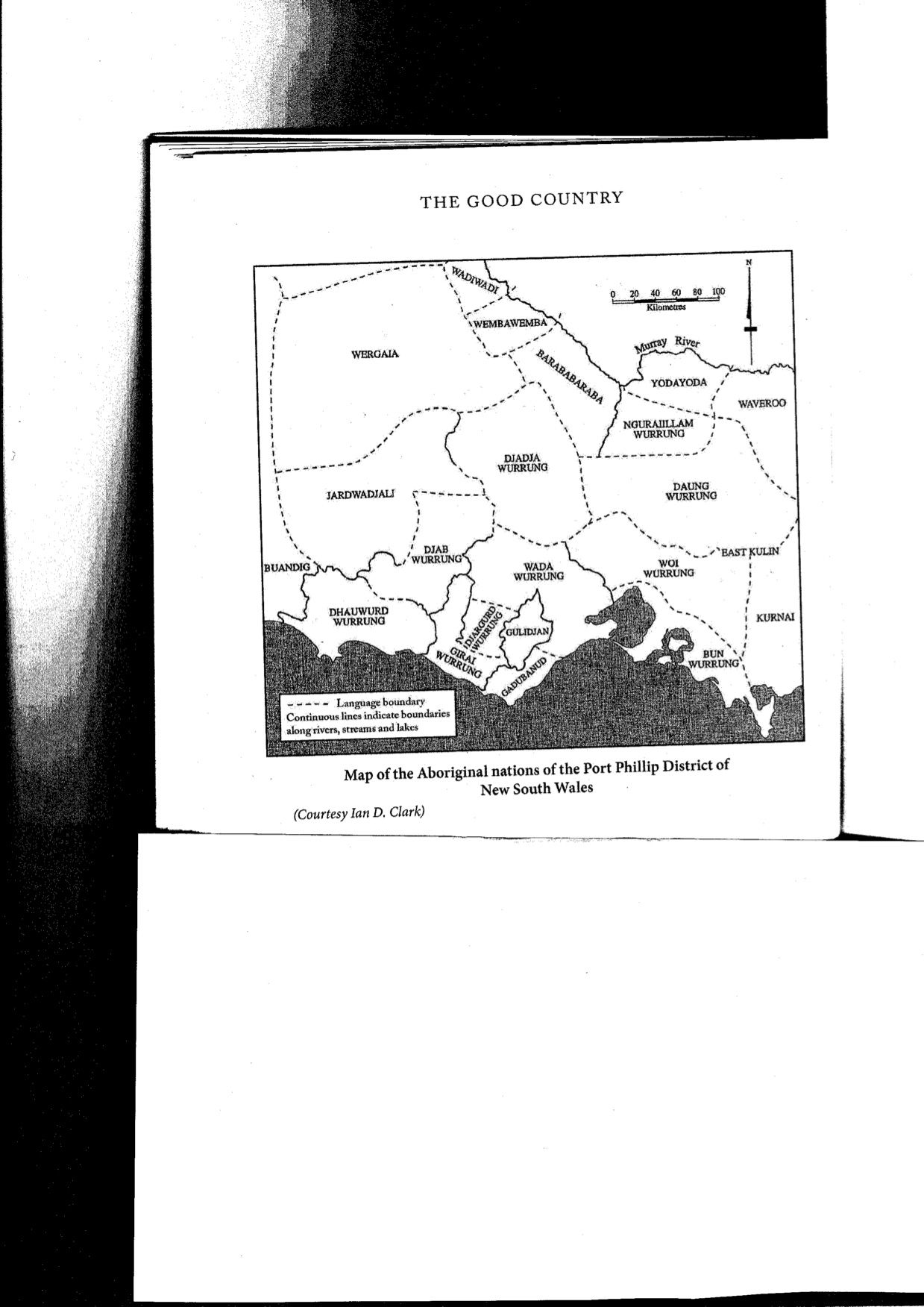
The Dja Dja Wurrung nation shared borders with six other Nations.
Pastoral Runs in Dja Dja Wurrung country (Map, see Attwood, 2017, p.14, after Swinton & McFarlane)

Most of the pastoral runs on this map were taken up within five years between 1838 and 1843, with those towards the south being taken up first.
Parker’s Sketch Map of March 1840 (Map, see Morrison 1966, p.17)
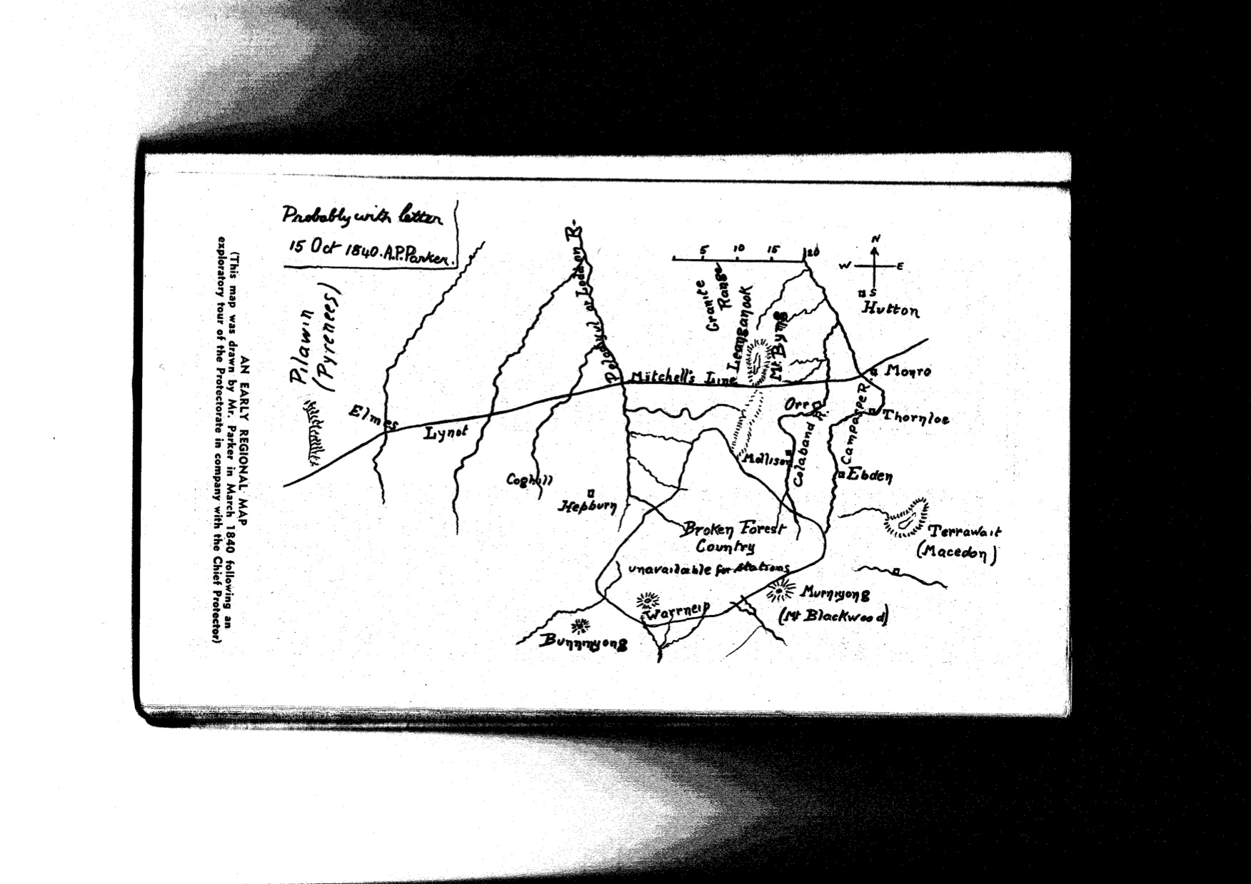
Parker sketched this map of the area in and around southern Dja Dja Wurrung country in October 1840 following reconnaissance with George Robinson in March of the same year. It shows how little was known aside from: ‘Mitchell’s Line’; the approximate course of some named rivers, including Polodyul or Loddon River, Campaspe and ‘Colaband’ (Coliban River) and the six obvious higher peaks or ranges: Macedon (Terrawait), Leanganook (Mt Byng of Mitchell, now Mount Alexander), Warrneip (Mount Warrenheip), ‘Bunninyong’ (Mount Buninyong), ‘Murniyong’ (Mt Blackwood) and Pilawin (The Pyrenees).
The 1840 map marks the approximate position of the white families who had already established the earliest pastoral stations: including, (from west to east) Elmes, Lynot, Coghill and Hepburn, Mollison and Orr (on the Coliban), Thornloe and Ebden (on the Campaspe) as well as Monro & Hutton. Parker marks the current extensive forest area (including the Wombat and Porcupine Ridge area on the very old Ordovician rocks as ‘Broken Forest Country Unavailable for Stations’.
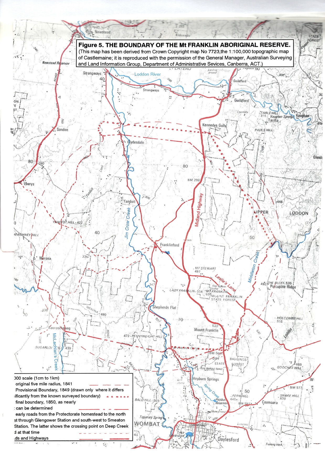
The original 1841 Protectorate boundary was defined as a circle of five-mile radius with present day Franklinford close to the centre. This circle also encloses present day Yandoit, Clydesedale, Werona, Shepherds Flat and Mount Franklin, including parts of present day Kooroocheang, Porcupine Ridge and Hepburn. The later surveyed boundary (1849-50) mostly sits within this five-mile circle.
The map below from Culvenor (1992) identifies the boundaries of the Protectorate as surveyed.
The Township of Franklinford Survey 1855 (Map)
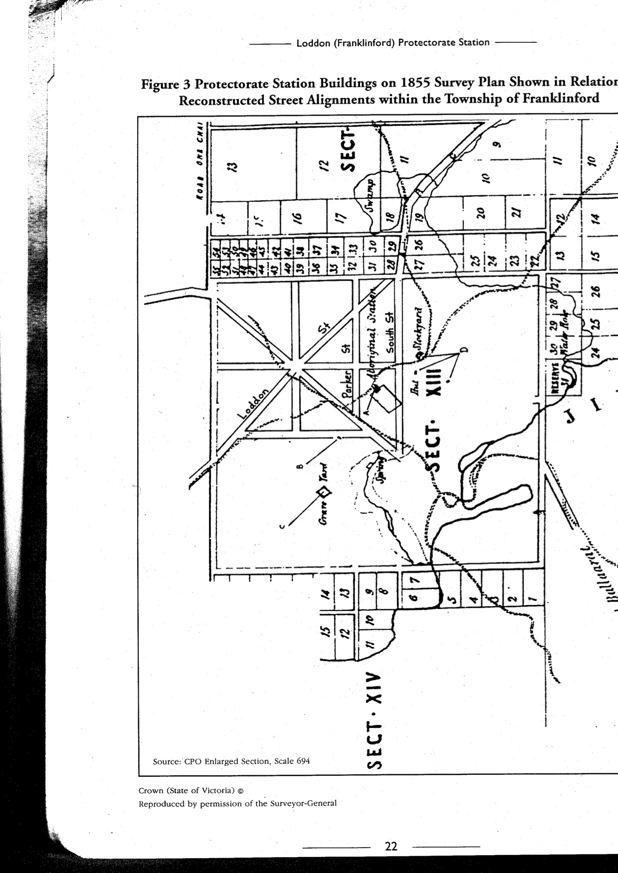
Edgar Morrison refers in one of his booklets to an early map of Franklinford on a solicitor’s office in Daylesford. Barry Golding located and made this copy of the undated map in then Pirie and Sutton’s office in the 1980s.

Aside from the Franklinford township plan, in the shape of a Union Jack, bounded by South Street, North Street, East Street, with the cemetery, swamp and spring to the south west, the map is superimposed over the original (discordant) boundaries of the Aboriginal School, at a different, earlier alignment to the later township. The map includes several surveyed streets that had ceased to exist to 2020, though some of the stone walls that marked previous street boundaries are still evident in the landscape.
The 1855 map below provides some detail of where Parker’s second house site was towards the foot of Mount Franklin, and indicates the adjacent areas that were being farmed at that time by two Aboriginal farmers.
The Dja Dja Wurrung Nation in brief summary
‘Dja Dja Wurrung’ in effect, can be translated as ‘Yes- Yes – tongue’. That is Dja or Dja Dja was the way Dja Dja Wurrung people said ‘yes’. To use an analogy, we might today call the French the ‘Oui Oui people’.
Clark (1990) notes over 100 different spellings of the same word for ‘Dja Dja Wurrung’ from 65 different sources. The Dja Dja Wurrung Nation originally consisted of round 20 clans sharing the same wurrung (speech name) with a degree of political and economic association. The Dja Dja Wurrung forms part of a larger group of Clans sharing religious and social ties. The Kulin have two moieties: bunjil (eaglehawk) and waa (crow). They were and remain the traditional owners of land in Central Victoria comprising the catchments of the Avon-Richardson, Avoca, Loddon and Campaspe Rivers south to the Great Dividing Range, bordered in part by Kyneton, Creswick, Boort, Donald and the Pyrenees.
Part C: Early contact in the Upper Loddon Catchment
The following extended account tells the story of incursions into southern Dja Dja Wurring lands and the effects on their peoples, most of which is in the footprint of the current (2020) Hepburn and southern Mount Alexander Shires. The area this account focuses on approximates the upper (southern) Loddon River catchment.
The account below has been roughly constructed around the diary records of G. A. Robinson, Protector of Aborigines, fully transcribed and published by Ian D. Clark in 1998 in six thick volumes, augmented by whatever other information was relevant and available from published and unpublished sources and online in 2020. I am grateful to my good friend Vic (and the late Felicity) Say for providing generous access to these and other valuable documents as well as encouragement and informing this research and writing.
In summary, the history of the former Loddon Aboriginal Protectorate and later Aboriginal Station at present day Franklinford spans 23 years between 1841 to 1864. There were actually three Loddon Aboriginal establishments, all under the control of Edward Parker: the first in 1840-41 on the Loddon River near present day Neereman; the second was the relocated Loddon Aboriginal Protectorate (at Franklinford) from 1841 to December 1848, and a third, later one, the Mount Franklin Aboriginal Station, from 1853 at the base of Mt Franklin. They were administered by three government organisations: the first two as part of the Port Phillip Aboriginal Protectorate from 1839-49; and the third by the Office of the Guardian of Aborigines (1850-59) and later the Central Board for the Protection of Aborigines (1860-1870). Most of the voluminous original records are preserved in State and National archives.
Hepburn ‘discovers’ Australia, 1829-1835
This and other sections specifically about John Hepburn (born 1803, died 1860) are included for several reasons. Firstly, because the story of his life during the early contact era is reasonably well known from already published sources. Secondly, because his considerable legacy lives on in the name of the now local government area, Hepburn Shire as well as the township pf Hepburn Springs in southern Dja Dja Wurrung country. Thirdly, because Hepburn’s life and times during the final two decades of his pastoral life have fascinating disconnects with what was occurring to Aboriginal people displaced from their lands by pastoralists at the Aboriginal Protectorate (and later Station) beyond Hepburn’s eastern boundary.
Many of the facts and anecdotes about John Stuart Hepburn’s life are available in Lucille Quinlan’s (1967) book, ‘Here my home: The life and times of John Stuart Hepburn 1803-1860, Master mariner, overlander, founder of Smeaton Hill. Like Edgar Morrison’s work from the same era, whilst well researched it tends unashamedly towards being a hagiography, a biography that treats its subject fairly uncritically and with some reverence. Whilst Hepburn kept a daily diary for much of his working life, even when he became a pastoralist it was more akin to a ship’s diary and was almost missing personal or emotional content. Consistent with other histories written during this era, Quinlan’s work was short on acknowledgment of any past or contemporary Aboriginal voice or agency.
John Stuart Hepburn was born in East Lothian, Scotland in 1803. The Smeaton Hepburn Estate in East Lothian was owned by a branch of the Hepburn family for almost four hundred years until 1934, when it was bought by the Gray family. The Estate and garden in Scotland was still open in 2018 to visits by the public. The grave of John Stuart Hepburn’s father, Thomas Hepburn was actually erected by John Hepburn in 1857 in the Whitekirk Churchyard in memory of his father who served in the Royal Navy. In Quinlan’s words (1967, p.4), as the Hepburn clan ‘increased in spite of diminishing fortunes … more and more Hepburns were driven into renting small farms from richer cousins, or working at humble occupations in the villages around.’
John Hepburn’s mother, Allison Stewart, died when he was four years old, and his father remarried. One of John Hepburn’s eleven siblings, his stepbrother, Benjamin also made his fortune in Australia, founding a stock and station agency in Ballarat in 1856 that became Crawford Dowling in 1928. It was Ben who had responsibility for the Smeaton Hill run whilst the Hepburns took a trip to England in the early 1850s.
After an elementary school education, John Hepburn found a berth as a cabin boy on an East Indiaman when he was only thirteen. Quinlan suggests Hepburn served on the Brig Ward under Captain Charles Hare in 1826 and the Barque Clara Grensome in 1828 though there is little independent supporting. evidence of these ships or ship Captain,
Hepburn’s first experience of Australia appears, in his earliest surviving diary from 1828, to have been as chief mate on the sailing ship, the Diadem that sailed from London to Port Jackson (Sydney) via Hamburg, where they picked up Saxon sheep, 279 of whom survived a gruelling 143-day passage. This very early Australian ‘live sheep import’ arrived in Sydney on 17 January 1829.
John Hepburn soon afterwards married Eliza Combes in Middlesex, England in 1830. Their first child, Alice Elizabeth, was born in June 1831 and their second, named after his father, also John Stuart, was born in July 1833. Hepburn’s working life between 1832 and 1835 had been as a master mariner on the Alice. During that time, whilst the family’s home base was in London, Captain Hepburn was mostly away sailing his relatively small brig three times around the world from Liverpool via the Cape of Good Hope to Hobart Town and Sydney and home via Cape Horn in South America. These voyages gave Hepburn increasingly wide social and business contacts on board and onshore, and a good working knowledge of both early colonies in Van Diemen’s Land and New South Wales. His cousin, Captain Robert Hepburn (see my separate blog) had already established an estate near present day Avoca in Tasmania and a whale fishery on the east coast of Van Diemen’s Land (VDL) and he had several good friends there.
Winds of unanticipated change for John Hepburn in 1835-6
In February 1835 whilst Hepburn was sailing the Alice from Hobart to Sydney, one of his passengers happened to be John Gardiner, a Dubliner who was giving up a banking career to invest in stock. Gardiner was previously a passenger on Hepburn’s voyage from England to Van Diemans Land and Sydney in 1833. Gardiner’s plan was to try his fortune as a squatter, and drive a herd of cattle overland from Sydney to the new colony at Port Phillip, something that had not previously been attempted. He invited John Hepburn to invest financially in the venture. Having invested his life savings of 200 pounds, Hepburn sailed back to Liverpool on the Alice in April 1835.
In the next few months there were a few unanticipated surprises that forced John Hepburn to change his lifestyle from worldwide mariner on sailing ships to a slightly more settled home and family life. On arrival back in Liverpool in August 1835 he learnt that their recently born baby son had died and his wife was mostly alone with their young children. After the Alice was refitted he sailed the ship back to Sydney, where it was sold by its owners to go into the emerging coastal coal trade between the Hunter River (now Newcastle) and Sydney. Hepburn was offered and accepted the command of a brand new, Australian-made steamship, Ceres, that was part of the same coastal trade and on a better salary. Meantime his wife had given birth to their second son, Thomas, and his family were preparing to emigrate from England to join him in Sydney.
John Hepburn appears during that time to have become stressed, unwell and overworked. Whilst he was recovering onshore in late August 1836, the Ceres, his 250 ton paddle wheeler, hit a rock mid voyage and was lost, totally uninsured. Without a ship to captain, Hepburn wrote that ‘Neptune had finally given me my discharge’, and gladly took up Gardiner’s renewed invitation to join his overlanding party to Port Phillip with a third partner, Joseph Hawdon, who already had a cattle station on the Moruya River on the then southernmost boundary of settlement south of Sydney. [As an interesting aside, after the success of their overland 1836 trip, Hawdon secured a contract at £1200 a year to carry the overland mail fortnightly to Yass, at which point his post-boy passed it to the mailman from Sydney who transferred the south-bound mail to him. This was a pioneer service; hitherto the mail had gone by sea. By the 1840s Hawdon was based in Victoria, founding the Pastoral and Agricultural Society and the Victorian Horticultural Society before finally settling in New Zealand in the 1860s.]
Around the same time the Australian newspaper, during the spring of 1836, devoted many articles about Port Phillip colony and ‘the adventurers from over Bass Strait who were taking possession of it’. Many of these adventurers such as John Batman came across Bass Strait from Launceston from already conquered districts in present day Tasmania. In April 1835 Batman hired a sloop, Rebecca, and sailed across the Strait and up Port Phillip Bay to the mouth of the Yarra.
Batman ‘explored’ a large area in what is now occupied by the northern suburbs of Melbourne. The basalt plains he travelled across were mostly treeless, and covered in dense swards of Kangaroo grass: it was a well managed Aboriginal grassland. It was, Batman wrote, ‘Land of the best description, equal to any in the world … the most beautiful sheep pasturage I ever saw in my life.’ Batman is best known for his role, in June 1835, identifying a site on the Yarra River, which would later become the city of Melbourne and negotiating a shamefully dishonest treaty. Batman was a controversial figure due to his dealings with Aboriginal peoples (including brutal massacres) even before he left Van Diemen’s Land and came to Victoria. The artist John Glover, Batman’s neighbour in Van Diemen’s Land, said Batman was ‘… a rogue, thief, cheat and liar, a murderer of blacks and the vilest man I have ever known’.
Early squatters coming north from Melbourne
The settlers coming from northern Tasmania to the early Melbourne settlement following Batman quickly identified fertile volcanic grasslands including some that were immediately south of Dja Dja Wurrung country. John Aitken sailed for Melbourne from Launceston to inspect the Port Phillip country on 20 July 1835. This was less than six weeks after Batman had returned from his first trip across Bass Strait. Aitken had been farming in Oatlands from 1833-4 and had arrived in the Gisborne area by June 1836, bringing with him the remnants of the flock of sheep he had brought over from George Town on the barque, Chili, which had run aground near Arthur’s Seat mid way through April. Aitken was soon joined by others including Henry Howey, who overlanded in February 1837 to briefly establish a sheep station where Gisborne now stands. In late 1838, Howey and his entire family were lost when their schooner, the Sarah, was wrecked off Ninety-Mile Beach on their way from Sydney to Melbourne to holiday with John Batman.
Mitchell passes twice through Dja Dja Wurrung country (Winter & Spring 1836)
Major Thomas Mitchell’s 1836 traverse across what is now inland Victoria is important as part of this narrative by virtue of being the first European to describe and give (mostly new European) names to most of the inland rivers and mountains of northern and Western Victoria, including those rivers already mapped, named and cultured by Dja Dja Wurrung peoples for around one thousand generations.
Mitchell’s diary, published in Three expeditions into the interior of Eastern Australia; with descriptions of the recently explored region of Australia Felix and the present Colony of New South Wales, records his 1836 overland expedition of ‘exploration’ from Sydney via the Murray River then south to Portland, returning via Western Victoria and present day north eastern Victoria.
While Mitchell made some notes about the local traditional owners he encountered, his main interest was in describing, naming and ‘opening up’ a country’ he regarded as essentially uninhabited. That said, his 25 man official party including his second in command, G. C. Staplyton carried a total of 36 firearms. The men were dressed in red woollen shirts and grey trousers crossed by white braces, ‘giving the men somewhat of a military appearance’ (p.2) as they set off, in Mitchell’s words, ‘to traverse unexplored regions, peopled, as far as we know, by hostile tribes’ (p.3).
The expedition anticipated using boats along and in order to cross some larger inland streams including the Murray and Darling Rivers, which they carried in a boat carriage. The several heavy wagons left their wheel ruts discernable for several decades after their expedition. The track the wagons followed was often already an Aboriginal highway, and the expedition’s track across Victorian’s northern plains quickly followed by squatters, sheep and cattle later became known as the ‘Major’s Line’.
Twice during this 1836 expedition Mitchell passed through Dja Dja Wurrung country, twice crossing the Loddon River. (This traverse is the subject of one of my separate blogs.) The first traverse and river crossing was in mid winter (late June and early July, 1836) whilst heading southwest between Pyramid Hill and the headwaters of the Richardson River. The second time the expedition crossed the Loddon River near present day Newstead in late September 1836, on router between Mount Cole and Mt Alexander as the expedition was heading back towards Sydney. Mitchell named what is now known as Mount Alexander (to the Dja Dja Wurrung, Leanganook) ‘Mount Byng’, though the name did not stick. Admiral John Byng, an English Royal Navy officer was court-martialed and shot dead by a firing squad in 1757.
Unlike Chief Protector of Aborigines, George Robinson, Mitchell not only took the country to be uninhabited but also prepared and predestined for European intrusion by a then unknown cause. Mitchell came close to identifying the then unknown explanation for such extensive areas of open grassland on what later became the heavily grazed and cultivated plains of northern and western Victoria when he wrote that:
On highest mountains and in places the most remote and desolate, I have always found every dead trunk and the ground and any living tree of any magnitude also, the marks of fire; and thus it appeared that these annual conflagrations extend to every place. (p.328)
What Mitchell described were grassland, wetland, woodland and forest ecosystems carefully and deliberately created and managed by tens of thousands of years of regular and systematic Aboriginal burning to encourage and sustain their desired food plants and animals.
On 30 June 1836 Mitchell was towards the north end of Dja Dja Wurrung country when he climbed to the top of Pyramid Hill and described:
… a land so inviting, and still without inhabitants! As I stood, the first European intruder on the sublime solitude of these verdant plains, as yet untouched by flocks or herds; I felt conscious of being the harbinger of mighty changes; and that our steps would soon be followed by the men and the animal for which it seemed to be prepared’ (p.159).
The ‘fine plain’ Mitchell and his wagons passed across the next day was covered with what both he and Robinson called anthisteria, now known as Themeda triandra, ‘Kangaroo’ or ‘Oat’ grass, also covered in places by what Mitchell recognised as Banksia and Casuarina, and what Robinson respectively called ‘honeysuckle’ and ‘oak’. By July 5 they passed a lofty hill Mitchell recorded as Barrabungale (likely present day Buckrabanyule, unbeknown to Mitchell the sacred home of the feared ancestral giant serpent, Mindi.
By 6 July 1836 the party were on a river Mitchell named the Loddon, because ‘… of its resemblance in some respects to the little stream in England.’ On 10 July they crossed and named the Avoca River, and on 13 July crossed and named the Richardson River after his botanical collector, John Richardson, who had an unplanned swim when his horse slipped during the river crossing. By July 19 they had encountered another river they ascertained from the locals to be the Wimmera.
By late August 1836 the expedition had passed north of (and renamed) Gariwerd / The Grampians, and travelled along the Glenelg River, launching their whaleboat to explore the wide and navigable lower parts of the river. They came onto the southern Australian coast downstream of present day Nelson close to the present day South Australian-Victorian border. On 29 August Mitchell’s party was ‘astonished’ when one of the expedition’s Aboriginal members (not listed but invaluable amongst the ‘official’ expeditioners) whom Mitchell called ‘Tommy Came-last’ came to him with the unexpected news of fresh cattle tracks, the ‘shoe marks of a white man’, ‘portions of tobacco pipes and a glass bottle without a neck’.
Mitchell understood that whalers and sealers had for several decades made camp along the same stretch of coast on Portland Bay, but the presence of cattle tracks astounded him. In Mitchell’s words, ‘How cattle could have been brought here I did not understand’. At anchor in the bay they found the answer: ‘The Elizabeth of Launceston’ and on shore ‘a considerable farming establishment belonging to Messrs. Henty’ that had been in place for at least two years. Mitchell wrote that Henty ‘was ‘importing sheep and cattle as fast as vessels could be found to bring them over’ (p.241).
The return journey towards Sydney took the party south of the Grampians, and apart from Mitchell’s personal side trip to climb and name Mount Macedon, on a steady north-east bearing across the ‘open downs’ of the Western District volcanic plains. The expedition re entered Dja Dja Wurrung country as they crossed the Great Dividing Range between Mount Cole and Mount Greenock (close to present day Talbot), both of which Mitchell renamed. Mitchell’s wagons skirted the base of Mount Greenock and headed northeast towards the open volcanic plains north of present day Clunes towards present day Newstead on a compass bearing of 60.5 degrees.
The intention was to head for ‘Mount Byng Pass’, effectively at the south end of Mount Alexander that had been in the expedition’s sights on the horizon for several days. The dozens of smooth, grassed, breast-like volcanic hills visible to the east of the summit of Mount Greenock Mitchell called the Mammeloid Hills. On 25 September 1836 as the party lumbered across this vast Aboriginal grassland, Mitchell wrote: ‘In travelling through this Eden, no road was necessary, not any ingenuity in conducting wheel carriages wherever we chose’ (pp.276-7).
As the party headed north-east onto the open grassy plains, Mitchell climbed a nearby ‘smooth round hill’, likely what later became known as Mount Cameron, to get the lay of the land and try and map the course of the many small northward flowing streams. Mitchell’s party:
… entered on a very level and extensive flat, exceedingly green and resembling an English park, bounded on the east by a small river flowing to the north-west (probably the Loddon) and abrupt but grassy slopes beyond its right bank.
Mitchell was correct in assuming it was the Loddon, the same river he had crossed around 100km north approximately three months earlier. Mitchell’s description on 28 September puts the party close to present day Newstead and heading through belts of forest and grassland towards present day Castlemaine. On 29 September the party found a route through the steep wooded ranges for their wagons, down onto the ‘more open granitic country at the foot of Mount Byng [Mount Alexander]’ near present day Chewton, naming it ‘Expedition-pass’. Mitchell was confident ‘that such a line of communication between the southern coast and Sydney, must, in the course of time, become a very considerable thoroughfare’.
At this point, at the foot of Mount Alexander, whilst waiting for repairs to the wagon carrying their boats, Mitchell resolved to take a side trip from his wagon train ‘to the lofty mountain mass which appeared about thirty miles to the southward’ (p.281). From this mountain, that Mitchell called Mount Macedon after Philip of Macedon, in honour of the fact that he was able to view Port Philip from the summit, he could see signs of European activity at the Port Phillip settlement in the form of ‘white objects which might have been either tents or vessels’.
Port Phillip had been briefly settled by the British near Sorrento on 1803-4, then left mostly undisturbed by Europeans until the previous year, 1835, when invaders from Tasmania led by John Batman and John Pascoe Fawkner (who incidentally had been at the Sorrento settlement as a child) established what later became Melbourne on the lower reaches of the Yarra River. Other early overstraiters developed a port near present day Corio,
On the return journey towards Sydney across what are now the northern plains, Mitchell went ahead to ensure he was first with the news of his discovery of Australia Felix, ‘the better to distinguish it from the parched deserts’ that Mitchell ‘had wandered so unprofitably, and for so long’ in western New South Wales. Mitchell wrongly took this Eden to be ‘still for the most part to be in a state of nature providing a fairly blank sheet’ for subsequently being carved up by European towns and lines of communication.
The expedition’s return route approximated the current Hume Highway, fording the Goulburn River near present day Mitchelton and the Murray River near present day Albury. Mitchell buried letters of instruction to Staplyton who followed behind him with the wagons. As Hawdon along with Gardiner and Hepburn were heading south on the first ever overland journey with 300 head of cattle towards Port Phillip in late 1836, they encountered Stapleton who was also crossing the Murrumbidgee River near present day Gundagai on his way back to Sydney.
Wider implications of Mitchell’s 1836 expedition
Whilst access to what is now coastal Victoria was reasonably well known from navigators, whalers and sealers in the first decades of the 1800s, before Mitchell’s 1836 expedition little was known by Europeans about what lay between the Murray River and the land north of the Great Dividing Range, aside from what Hume and Hovell had gleaned from their overland trip in 1824 between present day Albury and Geelong. On this trip the closest they came to the eastern edge of Dja Dja Wurrung country would likely have been near present day Broadford. Most of the Great Dividing Range that was known by 1836 from short, exploratory forays north from Melbourne and Geelong appeared to be forested ranges: country not suitable for grazing, and much of the land south of the Murray in north western Victoria was lacking in fresh surface water.
It was Mitchell’s two passes through northern and southern Dja Dja Wurrung country on his 1836 expedition that identified the rich potential for pastoralists in the rich wedge of grassland in central Victoria between the wet forests and the dry plains. Mitchell was born in Scotland in 1792 and would later take up the position of Surveyor General in New South Wales in 1837. Mitchell undertook three major expeditions of inland exploration in then New South Wales, the first in 1831-2 and the second in 1835. Both involved exploring parts of the inland river systems in New South Wales particularly the Darling River.
Mitchell’s third expedition elaborated above started on 17 March 1836. Mitchell had been instructed to travel to Menindee and follow the Darling River to its end. The original idea had been to travel down the Darling River to the sea, to see if it flowed there; or, if it flowed into the Murray River, to go up the Murray to the inhabited parts of the colony. However lack of water forced Mitchell to instead follow the Lachlan River to the southwest as the only practicable route. He reached the Murrumbidgee on 12 May 1836 and followed it to the Murray. At the end of May, Mitchell reached the Darling and turned north upstream. He soon decided, while still about 200 km (120 miles) in a direct line from Menindee, to abandon the survey of the deserts around the Darling and to use his resources to explore the more promising country along the Murray.
Retracing his steps, Mitchell went up the Murray until 20 June when he reached the junction of the Loddon River, where the country seemed so promising that he turned south-west into what is now Victoria. Mitchell was so enchanted by the area centred on what we now know to be Dja Dja Wurrung country and called it “Australia Felix”. It was Mitchell’s reports of excellent farming land on his return to Sydney with the news that started a land rush.
Whilst the Hentys that Mitchell encountered at Portland Bay in 1836 were the first permanent European pastoral settlers in this area from November 1834, sealers and whalers had camps at Port Fairy and Portland as early as the late 1820s. Henty provided Mitchell supplies and Mitchell headed for Sydney, convinced that that he had discovered a vast, fertile region, which would boost his fame as an explorer, that he optimistically dubbed Australia Felix.
Importantly, in terms of Dja Dja Wurrung history, whilst ‘explorers’ had been circling to the north, south and east of their nation for several decades before Mitchell’s traverses during July and September 1836, is was the deadly effects of two European introduced smallpox epidemics in 1878-9 and 1829 that preceded all of this physical meeting or ‘contact.’ It is clear from all of the evidence documented in Noel Butlin’s book, Our original aggression (1983), that these two smallpox epidemics had likely significantly reduced the Aboriginal population in south eastern Australia long before Mitchell in 1836.
Edward Parker, previously Assistant Protector in a public lecture he gave on ‘The Aborigines of Australia’ in Melbourne on 10 May 1854 (reproduced in Morrison, 1966), recognised that the smallpox scars still present from people who had survived earlier smallpox epidemics was linked by the Dja Dja Wurrung people to the large serpent Mindi (p.18). At the conclusion of his lecture, looking back after his fifteen years of public policy and program failure in Aboriginal affairs in Australia, Parker reflected deeply on what had already occurred in Australia in the process of ‘settlement’. He acknowledged the probability ‘that uncivilized races should perish before the march of civilization’, but denied ‘its inevitable necessity’ in relation to the Australian Aborigines, using Christian theology to back his contention. He finished with an exhortation, urging:
‘every Christian man … ’ to ‘.. rise, and say with one voice, to the government, to the legislature, and the nation; -occupy the land, -till its broad wastes, -extract its riches, -develop its resources, -if you will, but in the name of God and humanity, SAVE THE PEOPLE.’
Hepburn follows in Mitchell’s very recent tracks in 1836
Hawdon, Hepburn and Gardiner were the first with cattle (and later sheep) to follow the tracks of Mitchell’s huge wagons, soon to become a colonial highway referred to as ‘Mitchell’s Line’. As identified above, in October 1836 as the three men and their party were heading south with their 300 cattle, they actually encountered Granville Stapleton, of Mitchell’s expedition, bringing Mitchell’s wagons north on their return journey to Sydney, as they were both crossing the Murrumbidgee River near present day Gundagai. At this point they were close to the then settled frontier in 1836 in New South Wales: William Guise had squatted on a property called ‘Kimo’ near their mutual crossing point as early as 1830. Two weeks later the party and their cattle were heading southwest, crossing the Murray close to present day Howlong, having approximated the route of the present day Hume Highway.
During the river crossing Hepburn lost his mount, and for the rest of the long journey to Port Phillip during the early summer of 1836 he walked or rode in the dray. Following the still fresh wheel ruts of Mitchell’s huge wagons, they again approximated the current Hume Highway past present day Wangaratta, Benalla and Euroa, but then heading west, north of present day Seymour, to cross the Goulburn at Mitchell’s Crossing, near present day Mitchelton. The three men crossed the Great Dividing Range east of Mount Macedon and would have been on the border of Dja Dja Wurrung country in the catchments of the Coliban and Campaspe Rivers as they passed close to present day Kyneton, where they would have come into already invaded country, arriving with their cattle at John Batman’s village on the Yarra in December 1836. There is now a cairn near Dight’s Falls on the Yarra River, acknowledging the crossing of the river there of the three overlanders, including John Hepburn, in December 1836.
In December 1836 and January 1837 Charles Ebden also reconnoitered to the south of his two runs on the Murray River near Albury, set up pre-Mitchell’s 1836 expedition, in the spring of 1835 with his friend and manager, Charles Bonney, arriving in Melbourne only a few days after Gardiner, Hawdon and Hepburn.
This was not Gardiner’s first trip to Melbourne and there were other important colonial connections in Port Phillip that Hepburn would have benefited from. Gardiner had previously crossed Bass Strait with a cargo of 1,140 sheep from Launceston and visited the very early colony in January 1836 following an earlier trip across with J. T. Gellibrand in late 1835. As early as 1827, with John Batman, Gellibrand had unsuccessfully applied for a grant of land at Port Phillip, the petitioners stating that they were prepared to bring with them sheep and cattle. Gellibrand had accompanied the former escaped convict, William Buckley in a journey of exploration north of Geelong towards Gisborne in February 1836, yet again skirting southern Dja Dja Wurrung country.
Gellibrand returned to Tasmania and, in company with George B. L. Hesse, landed near Geelong in February 1837, intending to follow the Barwon River to its junction with the Leigh River and afterwards make their way to Melbourne across country. However the two men did not arrive at their destination and, though several search parties were organized, no trace of Gellibrand or Hesse was ever found. It is probable that their horses were lost and they died around the end of February 1837 in the heat of summer.
There is evidence that one of the search parties for Gellibrand and Hesse during 1837 almost certainly went through Dja Dja Wurrung country, see http://adb.anu.edu.au/biography/yuille-william-cross-4909 . The search party involved several prominent squatters including William Cross Yuille, John Aitken, Henry Anderson, Thomas Learmonth and his son, Somerville Learmonth, several of whom later took up runs in and around Dja Dja Wurrung country that they had ‘explored’ and traversed. Their starting point, documented in Withers (1878) History of Ballarat, was Aitken’s house at Mount Aitken south of Mount Macedon. They then went towards Mount Alexander, country very recently taken up by Ebden, Mollison and Yaldwyn, headed west to the Loddon and then towards a prominent peak now called Mount Ercildoun.
W. C. Yuille and his cousin, Archibald B. Yuille would later take up a run at Murgheballoak on the Barwon River but soon found the Aborigines there to be ‘troublesome’ and moved on to an area south of what was once called the ‘Black Swamp’ (later Yuille’s Swamp, now Lake Wendouree in Ballarat). In an interesting twist, Yuille settled south of the ‘Black’ Swamp (in the area which was to become part of the gold rush settlement of Ballarat) in 1838, and two years later, having sold his station there, went to New Zealand, where he was present at the ceremony of taking possession of those islands for the British Government by Governor Hobson, and the signing of Treaty of Waiting with the Maori. It is notable and shameful that 180 years later (to 2019) there is still no Treaty between the First Nations people and the national government in Australia. Returning to Victoria, Yuille embarked in squatting at Rockbank, occupying the country from within a few miles of Williamstown to Mount Cotterell.
Whilst they did not locate the missing men, during their extended search new country was ‘opened up’. They ventured to the north of Mount Macedon to Mount Alexander, and from there to the Loddon Plains, Mount Misery, Lake Burrumbeet, the Grampians Range to Mount Emu and back to the Barwon, a 1837 journey that verified Mitchell’s 1836 statements about the potential of Australia Felix.
In 1837 a party of white men travelled northwards towards Mount Buninyong. These were Thomas Livingston Learmonth, Mr D’Arcy (a surveyor), Mr David Fish, Dr Thompson, Captain Hutton (of The East India Company) and Mr Henry Anderson. From Mt Buninyong they sighted the distant Lake Burrumbeet. In January 1838, a second expedition consisting of Mr Thomas Livingston Learmonth, S. H. Learmonth, W. Yuille, J. Aitken and H. Anderson. Following a slightly different route they crossed the wealth of the gold fields, still to be discovered and came at length to a small peak to which they gave the name “Ercildoune” in memory of the Scottish border keep where dwelt an ancestor of the Learmonths. |
Being on both of these expeditions, Learmonth is a reliable primary information source. Learmonth recalled the August 1837 expedition ( in August 1853, in Letters from Victorian Pioneers, p.95), noting that they used ‘one of the aboriginals as a guide, in order to explore the country in the neighbourhood off Buninyong, the only hill that breaks the horizon to the north-west of Geelong.’ They also continued on to Lake Burrumbeet, but finding the water brackish and the country too distant for occupation, returned back to the Barwon River near present day Geelong.
Learmonth also wrote about their January 1838 expedition, undertaken just three months before Hepburn arrived overland to take up Kooroocheang (Smeaton Hil). This expedition certainly traversed much of Dja Dja Wurrung country, likely for the first time since Mitchell’s return traverse in late 1836.
Learmonth recalled (writing in 1853) that in January 1838 from:
... Mt Aitken’s Station we went to Mount Macedon, at which Mr Ebden then resided, and thence to the Coliban, where Mr A. F. Mollison had just taken up stations, with stock from the Middle District. This was the farthest station at the time in that direction; but within 12 months Messrs Coghill, Captain Hepburn and others had pushed on farther. From Mr Mollison’s station we passed by Mount Alexander, followed the Loddon down over the localities lately rendered famous by the gold mines of Forest Creek and Bendigo, and crossed the plains of the Deep Creek to the Mount Beckwith Ranges … to Mount Misery. (p.97)
It is pertinent to add a fragment of a later letter from Learmonth to La Trobe (undated from ‘Letters from Victorian Pioneers’) seeking to explain:
‘…. this rapid disappearance of the native tribes in our own district, it is a pleasing subject of reflection that, notwithstanding our having had a servant killed, others attacked, and sometimes our sheep destroyed, we have never been brought into personal collision with them; nor have we been instrumental in taking the life of a single individual; and, moreover, I am free to confess that, considering the wrong that has been done to the aborigines in depriving them of their country, they have shown less ferocity and have exhibited the desire to retaliate less than might have been expected.’
‘ I consider the disappearance of the native tribes in this district to be owing, not to the result of encounters with the stockmen and early settlers, but to the vices introduced by the white men among them, and to the change in their habits, by which the active exertion of the hunter’s life was exchanged for the idleness and, commonly, the plenty they enjoyed in their new condition of beggars, thereby inducing diseases and catarrhal affections, to which they were not subject before; for I believe that there is no surer way of extirpating a race of savages like the Australian native than by supplying them freely with food, and thereby taking from them the necessity for personal exertion.’
It is also pertinent to add here that the approximate route of Mitchell’s Line that became a veritable east-west highway across the Loddon and through southern Dja Dja Wurrung country to overlanders was used for many decades afterwards and later referred to locally as the ‘Adelaide Road’. During the early days of the Mount Alexander diggings Gold Escorts used part of the east-west route via Newstead taking gold to Adelaide during the 1850s.
Hepburn comes overland with his family
Hepburn returned with Hawdon from their 1836 overland expedition to Port Phillip in December 1836 by hiring a ten-ton cutter then moored in the Yarra, which he sailed up the east coast to Hawdon’s brother’s property Burgalia on the Moruya River area in New South Wales. Hawdon would go on in 1837 to overland more stock to Port Phillip. Hepburn, on his return journey overland from Burgalia to Sydney in January 1837, fortuitously met up with Captain John Coghill and his brother William. The Coghill brothers were then settled on properties near Braidwood in New South Wales, midway between present day Canberra and Ulladulla. [NOTE: Some of the detail which follows about the Coghill brothers, William and John, was provided in January 2024 by David McKay. It corrects some of the errors in my previous account].
John Coghill (often referred to as Captain Coghill, in recognition of his maritime background) owned property at some stages at both Kirkham and Strathallan. By 1837 William Coghill was well established on a property called “Newick” or Newwick” (after the town in northern Scotland from which he emigrated) between the Kirkham and Strathallan). William obtained this land through a Crown Grant of 600 acres. However, his land was also referred to from time to time as “Currockbilly” and “Wingeecarribee”, with the latter spelt a variety of ways.
In the spring of 1837 Elizabeth Hepburn arrived in Sydney from England with John Hepburn’s six-year-old daughter, Alice and his one-year-old son, Thomas, whom he had never met, and the family went back to the 5,600 acre property at Strathallan, named “Bedervale”, sometimes called “Beder Vale” then owned by John Coghill, William’s younger (but far better known) brother. The Hepburns would later have several other children. Elizabeth Hepburn was pregnant with George during their 1838 overland journey. Eliza was born in 1840, Henry in 1842 and their twin girls, Mary and Helen were born in 1845.
During 1837, Hepburn and John Coghill had become partners in a plan to overland 1,400 ewes, 50 rams and 200 wethers to central Victoria. Hepburn then had very little in the way of financial resources after leaving behind his maritime career. He had made next to no money on the overland expedition with Gardiner and Hawdon. Hepburn must have convinced John Coghill of the viability of his plan to move overland and squat on land that Mitchell described as ‘Australia Felix’ and John Coghill supported Hepburn financially for at least a decade – as Hepburn related in his letter to La Trobe of 1853.
They took with them Hepburn’s family and ten male prisoners of the Crown in two drays with 18 bullocks a horse and cart and a saddle horse.. For much of the 600 km journey between Goulburn and Seymour, the party followed some of their 1836 tracks and Mitchell’s Line. On 15 January 1838, the party left Strathallen heading for Australia Felix. Shortly after leaving Gundagai they met William Bowman and the three parties travelled southward, spaced one day apart, this time crossing the Murray River higher upstream at Hume’s crossing near present day Albury.
Where William Coghill’s party started, and its membership is uncertain. It is possible that the party started from ‘Newick”, near Berrima or perhaps from a pastoral lease that he held in the Maneroo District (now known as Monaro) and moved down the Murrumbidgee to meet up with Hepburn.
They were by this time following not only the Majors Line but also following the tracks of other overlanding parties including Charles Ebden. Ebden, at least six months before, in August 1837, had already overlanded and settled on the Campaspe River west of Mount Macedon in an area he named Carlsruhe. He was thus the first pastoralist in the Port Phillip district to invade north of the Dividing Range on the margins of Dja Dja Wurrung country. Ebden was joined six weeks later by another overlander, William Mollison, who had overlanded during 1837 to ‘take up’ the ‘Tarringower’ run on the Coliban in the now Malmsbury district, joined by his brother William in 1838.
Other overlanders in front of them included Howey as well as George Hamilton (who the following year again overlanded cattle to Adelaide). By the time they crossed the Goulburn River several other overlanders were ahead of them, including H. C. A. Harrison (who settled near present day Yan Yean), and ‘Captain Brown’. John Hepburn had intended to take up a run near where he marked a tree at a locality later known as ‘Browns Creek’ during his 1836 trip, but Brown had beaten him.
Notes compiled about Aitken’s role in the Mount Aitken Pastoral Station (see http://vhd.heritagecouncil.vic.gov.au/places/195376/download-report indicate that these early overlanders and squatters were not passively endured or welcomed by local Aboriginal people.
‘While Aitken, Evans and Jackson and other ‘overstraiters’ ventured northwards from Williamstown, ‘overlander’ parties from NSW, such as Howey, Coghill, Riddell and Hamilton … penetrated southward; the two streams [of overlanders] meeting among the hills between Sunbury and Gisborne. Thus … ‘these hills take pride of place in the pastoral and agricultural development of the State … ‘ Relations with the Aboriginal People Notwithstanding the help Aboriginal people had given [Aitken] in landing sheep at Dromana in 1836, relations with the local Aboriginal people at Mount Aitken do not appear to have been cordial. There are several accounts of his encounters with the local Aboriginal people. The most dramatic account, by a contemporary, has him locked in hand to hand combat with a single native intent on his provisions, from whom he managed to escape by mounting his horse and fleeing. Although in his late fifties during Victoria’s squatting phase, Aitken was strong and powerful. In 1838 he narrowly escaped being hacked to death by a native armed with a tomahawk, apparently a deliberate act of resistance by local natives to the occupation of their land – in April 1838.’
‘ A party of 40-50 ranged widely around the territory, going first to John Aitken, who managed to dispossess them of two of their three guns. He recorded the incident:- ‘I was attacked by about 40 native blacks at my station on the 14th of April last. They came to me armed with spears and three guns. I called my men about me when they came up. They stood still and we brought out what guns we had in the hut, and we called out as if there were other people about us. The blacks then retreated about a hundred yards and got behind a rock. I rode up and, when within 30 yards, two of them levelled their guns at me over the cover of the rock. I then rode around them, and came in behind them. There were three or four under cover and on my getting behind them they went up to the rest of the tribe. I followed and got the assistance of Mr White and then went up to the black and succeeded in getting two guns from them. They cocked their guns as we went up to them. When I took hold of the gun the black named DeVilliers or Warra Worrock attempted to strike me with a tomahawk. After taking the guns, the blacks went away.’
The next day, with women and children, the party visited George Evans (Emu Bottom) and camped at Jackson’s (at Sunbury), threatening a shepherd, spearing sheep and setting their dogs upon the flock, driving up to 50 away. They continued on to other squatting stations towards the Werribee where similar ‘depredations’ took place. On 19th May the speared and disembowelled body of shepherd Samuel Fallon was found near Mt Macedon. A party of seven natives were captured and taken to Sydney for trial.
Another view of Aitken and the natives during these episodes is recorded by Batey. Original pioneer Kenneth Scobie Clark, pastoral manager for the Great Lake Company, had told him:’ Aitken would not permit the aborigines to trespass upon his run, and also that the blacks feared him. One of his [Clark’s] items was to the effect that Aitken, grappling with a native, did his best to break the man’s neck.’ While Batey conceded that Clark was not always the most ‘strictly reliable’ witness, the Clark account of the blacks’ attitude to Aitken was corroborated by another, reliable, witness ‘who recounted an old lubra who asked him if “Debbil debbil was dead” meaning of course, John Aitken.’
To return to the party of 1838 overlanders who were now firmly within Dja Dja Wurrung country, Hepburn and Coghill resolved to head further west to country that Hepburn regarded, to quote Lucille Quinlan’s Here my Home from 1967, as ‘the pick of Port Phillip and theirs for the taking’.
According to Hepburn (in Letters from Victorian Pioneers, p.68) several other station holders were already in or adjacent to what we now acknowledge to be Dja Dja Wurrung country, including A. Mollison (on the Coliban, afterwards sold to Mr Orr); C. H. Eden (initially on Sugarloaf Creek, but abandoned in order to take up Carlsruhe); Howey to the east of Mount Macedon, later Riddell and Hamilton’s station and the township of Gisborne); Brown on a station later taken up by Dr Baynton, and William Hamilton took up Sugarloaf left by Eden.
In the first week of April 1838 Hepburn first sighted a mountain Mitchell had called Mt Byng (Leanganook to the Dja Dja Wurrung, now Mount Alexander) where they set up a lambing camp. William Bowman peeled off north to establish the Sutton Grange run on the Coliban to the north east of Mount Alexander, soon taken up instead by James Orr. Hepburn had hoped to settle on this area he had passed through in 1836 but found it was all taken by these previous overlanders. From Mount Alexander, Hepburn sighted Mount Kooroocheang, the Major’s ‘Mammaloid’ hills, a cluster of relatively smooth and rounded, breast-like volcanic hills. The Hepburns moved on to establish the Smeaton Hill run on 15 April 1838. William Coghill travelled further west, crossing Bullarook Creek, first establishing Glendaruel near Mount Beckworth and then Glendonald (on Cattle Station Hill between Creswick and Clunes).
On 12 April 1838 Hepburn and family had camped at the now site of Castlemaine, whilst two lambing camps were set up: one south east of Mount Alexander, and the other close to present day Guildford. The Hepburn family had initially camped in a tent at what became Smeaton Hill station after three months of arduous travel.
Less than two years later, when E. S. Parker and G. A. Robinson arrived at the Hepburn’s station on 13 February 1840 Robinson’s diary records much about the situation he encountered:
Captain Hepburn’s is, excepting Ebden’s, the best regulated and laid out station in the district that I have seen. Captain Coghill is a partner with Hepburn. John Hepburn at Port Arthur, who was with Sir John Franklin in all his expeditions to the North Pole, is cousin to Captain Hepburn. John Hepburn is married. His wife is in England … Has now three children, two boys and a girl … Captain Hepburn’s house is large, 50 feet by 50 feet outside measure. Built of pisa [pise: mud brick]. Very substantial out office of the same. A good deal of split rail fencing is done there on several gardens and a large woolshed … and an excellent wool press.
Having had a good look around, Robinson writes on 14 Feb 1840 that the hill opposite his home:
Called 1. Kor.er.tan,ger, 2. Koor.er.tan.ger, Hepburn Hill. This is the highest hill in the neighbourhood. Another bald hill adjoining is called More.er.kile. The Loddon river is called Min.ne min.ne. Tarrac [likely Native geranium, Geranium solanderi] a small tuberous root eaten by the natives, having a red flower resembling a geranium. Murnong has a tuberous root also and a yellow flower. … Captain Hepburn is cultivating murnong in his garden.
During the 1840s most of Hepburn’s neighbours were other overlanders who had also forcefully acquired large tracts of carefully managed Aboriginal grasslands for sheep grazing during 1838-9. The Birches (second cousins Arthur and Cecil Birch) were at Seven Hills, Donald Cameron set up the Clunes run in 1839, and his uncle, Captain Dugald McLachlan was at Glengower near present day Campbelltown. Hepburn later recalled in ‘Letters from Victorian Pioneers’ how quickly land was taken up and changed hands’.
‘I took up Smeaton Hill on the 10th of April 1838, having just been three months travelling. About ten days after, the Coghills took up their stations, Glendaruel and Glendonald; Harrison, who was too wise to be advised by me, came nearer the settlement, and took up a country I am not acquainted with, viz., the Plenty. After being some months on our respective stations that is Coghill and myself we found to the south of us the country about Buninyong taken up by Learmonth; the Leigh River by Yuille. Between the last-mentioned parties, Anderson took up a station, thus crowding the stations so close that in a short time they found out their mistake. The same year Pettett and Francis took up Bowling (sic.) Forest, which would have been my run only for my ignorance, thinking it too rich for sheep. Messrs. Irvine and Birch made their appearance, and sat down between Smeaton and Glendonald, and called the station Seven Hills. In 1839 the early part of this year Mr. W. Kirk took up the run outside me, but abandoned it, and took up a large run west of Mt. Cole, afterwards Ross and McGill’s. Then came Capt. McLachlan and D. Cameron, who both sat down on Smeaton. McLachlan, after much persuasion, took up the ground left by Kirk, and D. Cameron that left by Irvine, now known as Clunes. About this time, Simson, Dutton, and Darlot took up the Loddon …’
The terms ‘sat down’ and ‘took up’ sound so benign, but it was far from that easy or simple. Hepburn acknowledged in ‘Letters from Victorian Pioneers’, written in 1853 that ‘a hostile feeling did exist’ … ‘with respect to the natives’ in the process of taking up his station in 1838, but he attributed much of the blame to his men, who he claimed ‘paid smartly for their impudence’. Hepburn also wrote ‘With respect to the natives I can say but little, having had little intercourse with them’, and that ‘after all his residence with the natives ‘I never learnt one word of they lingo’. He also acknowledged that whenever ‘natives made their appearance’ and he ‘showed his face’, they always disappeared. Hepburn also wrote that Mrs Hepburn treated the Aboriginal women well.
Until the early gold rush of the 1850s, Hepburn’s mail came from what Hepburn called ‘Jim Crow’ via the adjoining Loddon Aboriginal Protectorate (1842-9).
As Aitken and other early ‘settlers’ to the southeast had discovered, Dja Dja Wurrung land was not empty land for the easy taking. Within days of Hepburn’s arrival, one of his ex-convict party, Knight, was killed by Aborigines close what is today called Yandoit Hill. The site is still known today by locals as ‘Knights fall’. Another, ex-convict Lee was badly wounded, likely in a reprisal attack. These attacks had occurred in what Hepburn later dubbed the ‘Jim Crow’ area that would later become the Loddon Aboriginal Protectorate. Four months after Hepburn took up the Smeaton Hill run, Ebden, from his station near Carlsruhe to the east of Dja Dja Wurrung country, was writing to the Sydney Herald pleading that ‘If the government do not immediately give us the protection we require we shall be compelled to turn out in a body against [the blacks]’.
Why call ‘Mt Franklin’ ‘Jim Crow’ (and why not)?
A process is underway in 2020 to rename the Jim Crow Creek. The account that follows gives some background to this name and its original naming.( My separate blog teases this out in more detail).
The term ‘Jim Crow’ was used by Hepburn from as early as 1839 to describe the area and mountain east of his station around Mount Franklin. What is not certain is whether Hepburn gave the area and mountain the name or repeated a pre-existing name, though the evidence so far, in my view, strongly points to the former. Whatever is is called, the top of Lalgamobook / Mount Franklin is just visible above the forest from several higher parts of Hepburn’s 1838 run.
The term ‘Jim Crow’ originated in America. A minstrel song, ‘Jump Jim Crow’ was written in 1828 by a white entertainer for white audiences, that relied on a negative racist (blackface) caricature that depicted ‘dim witted’ African American ‘negro’ people. In the early 1830s, white actor Thomas Dartmouth “Daddy” Rice performed minstrel routines as the fictional character “Jim Crow” – a clumsy, dim witted black slave.
Rice claimed to have developed the character after he saw an elderly black man singing a song called “Jump Jim Crow” in Louisville, Kentucky. John Hepburn knew and referred to the song as a catchy tune he could not get out of his head. A ‘Jim Crow Museum’ started in the US in 2013 tells the story well for visitors to the museum: see https://www.youtube.com/watch?v=yf7jAF2Tk40. A comprehensive explanation of how Jim Crow laws evolved in the US is found at https://www.youtube.com/watch?v=2_gOtZ–4WE.
Each of these YouTube clips come with a strong warning that some people in the US might find the content and the term Jim Crow very offensive. The material is reproduced in the US in order to help inform and educate Americans about their history. I figured that there would be no way any place or physical feature in the US landscape in 2018 could still be called Jim Crow, but found a Jim Crow Creek in Sierra County, California as well as in Washington State in the United States. In 2018, aside from our ‘Jim Crow Creek’ here in Victoria there is a ‘Jim Crow Mountain’ and National Park near Rockhampton in Queensland, which the Darumbal people in the area have successfully encouraged the State Government to change.
The Jim Crow Laws were racial segregation laws enacted after the Reconstruction period in Southern United States, at state and local levels, and which continued in force until 1965, which mandated racial segregation in all public facilities in Southern states of the former Confederacy. The separation in practice led to conditions for African Americans that were inferior to those provided for white Americans, systematizing a number of economic, educational and social disadvantages. These Jim Crow laws followed the 1800–1866 Black Codes, which had previously restricted the civil rights and civil liberties of African Americans with no pretense of equality. Jim Crow was the derogatory name for a black person at the time Lalgambook / Mt Franklin (called ‘Salus’ by Major Mitchell, after the ancient Roman God of health and prosperity) was dubbed ‘Jim Crow’, including by John Hepburn, perhaps as early as the late 1830s.
There has been an onging debate in recent years about the appropriate name for what is today called ‘Jim Crow Creek’ in the Hepburn Shire, given the racist connotations of the term Jim Crow, particularly in the US. There are several instances in Australia where similarly racist place names, such as ‘Nigger Creek’ have been officially expunged. John Ross, in July 2012 wrote the following on the www.yandoit.net web site.
The earliest reference to the name ‘Jim Crow’ that I have found was by Edward Stone Parker in his report of September 22nd 1839. In John Tully’s book of the Djadja Wurrung Language, he states that Jim Crow is a corruption of jumcra, the aboriginal name for the area. I have not discovered an original source for the corruption ‘Jim Crow’. It is unlikely that Parker coined the corruption because he was familiar with aboriginal names and referred to them regularly in his writings.
‘Jim Crow’ would have been a familiar phrase at that time, and least to those who had knowledge of North America or English theatre as explained below…
(Thanks to Bill McClenaghan for his contribution to the following section)
“Jim Crow” was a stage character created in 1828 by a travelling white minstrel called Thomas “Daddy” Rice, who used to blacken his face (as Al Jolson did a century later). By 1830 the “Jim Crow” character had become his signature act. Rice was very popular and toured extensively in North America. He was known in England too. He was mentioned in the Times in 1833, he toured England in 1836 and married there in 1837.
Why Rice chose that name is the subject of debate and nobody knows for sure; perhaps the name of an old black slave or a ragged black stable boy. In any case, it became synonymous with black Americans and other racial groups considered inferior at the time in American society. Decades later, segregation laws would become known as the “Jim Crow Laws”.
So it is likely that any English settlers in the Colony who had been to the theatre back home would know of the character “Jim Crow” and would associate the phrase with black people. Upon hearing the local Aborigines use the term jumcra, one can speculate how they might easily arrive at the corruption “Jim Crow”.
I have just found some information (from Ballarat Genealogy) that claims two of Alexander Mollison’s shepherds coined the name ‘Jim Crow’ when they established a western extension of Mollison’s run in 1840, further that Mollison wanted to change the name to ‘jumcra’. But then according to Edgar Morrison’s book, Parker referred to the name in 1839. Maybe some of these dates are a bit fuzzy. I will try to verify the original source and date of this information. The Ballarat Genealogy page states as follows:
“Alexander Mollison, in a letter to his sister Jane on April 30th 1840 tells of the naming. “One of my finest sheep runs is nicknamed ‘Jim Crow’ and a young settler, not very refined in his ideas, and who stutters painfully, amuses me when I chance to meet him, he pertinaciously reporting ‘Ah it was m-m-m-m-me that called it J-J-J-Jim Crow’. I have Australianised it into Jumcra but with little effect.”
On 14 February 1840 , whist Robinson was staying with John Hepburn, Robinson refers in his diary to ‘… a hill Mr Hepburn calls Jem Crow on account of the numerous small hollows about it.’ Lucille Quinlan (in 1968) cites Hepburn (Letters from Victorian Pioneers: Hepburn to La Trobe), whilst talking about the 1838 Knight killing, saying he was passing over ‘Jim Crow (Mount Franklin]’ whilst looking for Knight, but there is no date given for the letter.
If the creek were to be renamed, it would be highly desirable that it be the original Dja Dja Wurrung name. On 20 Nov 1841 G. A. Robinson visited the Loddon Aboriginal Station and wrote that ‘The creek or branch of the Loddon is Lulgambook.’ Other sources including E. S. Parker suggest that this was the name of Mount Franklin. On Parker’s early and therefore very simple sketch map made in March 1840 (reproduced in Morrison (1967, p.19) the Loddon River is called Polodyul. Some of the other names cited for the Loddon River (or perhaps its tributaries) in Dja Dja Wurrung language (from Wikipedia, without source) include Yarrayn, Minne-minne and Pullergil-yaluk, all with no clearly defined meanings.
The debaters might usefully refer to the book Indigenous and minority place names by Ian D. Clark, Luise Hercus, and Laura Kostansk. In Chapter 14, Ian Clark includes a discussion about ‘Jim Crow Hill’, as follows verbatim.
[Jim Crow Hill] was an early name for Mt Franklin, and was the name of a creek, range, and gold field north of Daylesford. ‘Mt Franklin’ named after Sir John Franklin’s visit to the Loddon Protectorate station in 1843 displaced ‘Jim Crow Hill’. According to Saxton (1907: 36) Jim Crow Hill was ‘Named by Capt John Hepburn. Capt. Bacchus, who accompanied him, asked what name should the ranges have, and Hepburn replied: Jim Crow, after a popular song’. Morrison (1967: 41) explains that the origin of the name ‘Jim Crow’ has intrigued many for a long time.
Some believe it is the name of a former ‘king’ of the local Loddon tribe of Aborigines. Etymologically, the term “jim crow” was used for various implements, as for example, a “jemmy”, which is a miniature form of a bent crow (bar) and, somehow, the idea of bending or twisting seems to be implicit in its derivation. A device for bending iron bars was one time termed a “jim crow”. About 1835, an American negro, James Rice who was a rather popular “song and dance” comedian wrote and popularised a song, the chorus of which was: “Wheel about and turn about and do just so, Turn about and wheel about and jump Jim Crow”. Set to a catchy tune it swept the world, as similar songs do today. … There seems to be no reason, to doubt the accuracy of the story that the application of the term “Jim Crow” to this region, stems from a trivial incident wherein Capt. Bacchus, riding on horseback between “Lalgambook” and Kooroocheang with Capt. Hepburn, called to his companion, “What do you think we should call these ranges?” Hepburn (perhaps with the maddening refrain churning in his mind) replied: “Call them Jim Crow!” (Morrison 1967: 41).
Quinlan has noted that Mount Franklin which the early squatters called Jim Crow and the natives knew by the name of Lalgambook. John Hepburn used the name Jim Crow to refer not only to the mount itself but to the creek below it and to the district. Edgar Morrison who, in 1965, published the memoirs of Edward Stone Parker under the title Early Days in the Loddon Valley, believes that Jim Crow derives from the chorus of an American minstrel song, popular at the time of the first overlanders. It seems quite feasible, as he suggests, that the behaviour of this winding creek recalled to someone like the Mollison brothers the popular jingle, ‘Hop a little, stop a little, jump Jim Crow’. Later, when the aboriginal station was established there, many took it for granted that the word referred to the natives (Quinlan 1993: 99).
According to Blake (1977: 133), overlander Alexander Mollison’s records list the district as ‘Jumcra’, ‘Aboriginal name for which meaning not traced; “Jim Crow” was minstrel song from U.S.A. 1835’. Randell (1979: 222) in a history of the Coliban district explained that Mollison took up two stations in the vacant land immediately west of his Coliban station in early May 1840, naming the Loddon run ‘Jumcra, probably an aboriginal name. The second run was called Boughyards. The men soon corrupted the first name into Jim Crow’. Tully (1997: 87) supports the view that Jumcra was corrupted to Jim Crow.
Norm Darwin, a Daylesford local historian wrote a draft for a book about ‘Daylesford District History’ in 1988, whose Chapter 3 includes an account of Mollison’s extension of his run beyond his ‘western boundary, a north south ridge’ in early 1840. In Darwin’s account, being ‘short of grass’ Mollison ‘dispatched two men [Richard Babbington and Henry Jackson] to look west for suitable grazing land … with material to construct huts and bough yards. They brefly established two outstations. The first was on the current Jim Crow Creek, which later became the Aboriginal station site. The second was on the Loddon near the present site of Guildford. The first outstation was settled by shepherds on 1 May 1840, consisting two huts and rough bough yards. Darwin writes that ‘Mollison named his new run Jumra. Thought to be an Aboriginal name, Mollison’s two shepherds Macleod and Macfadden corrupted the name to Jim Crow’. On 30 April 1840 Mollison wrote to his sister, Jane talking about the name of his station, quoted verbatim from Darwin (July 1988, draft, p.5):
One of my finest sheep runs is named ‘Jim Crow’ and a young settler, not very refined in his ideas, and who stutters painfully, amuses me when I chance to meet him, he pertinaciouosly reporting ‘Ah it was m-m-m.m-m-me that called ot J-J-J-JimCrow’. I have Australianized it into Jumcra but with little effect.
This explanation in Mollison’s words, three months after Robinson wrote that Hepburn calls the area ‘Jim Crow’ seems dubious. Likening the name Jumcra and its etymology to a later corruption of the words ‘Jim Crow’ that one of his shepherds stuttered is perhaps something of a rationalizing and patronizing explanation of a term he and likely his sister would have known to be racist. Otherwise, why would Mollison have said the run is called Jim Crow? Why would he have tried to ‘Australianize’ it into Jumcra? And why would he tell the story to his sister other than to pass on the blame for his deliberately corrupted name to one of his shepherds?
There is evidence from Robinson’s diary on 10 Feb 1841 that at least one Aboriginal man had taken (or been given) the name, specifically a man called ‘Bad.ge.bow.wur.nung alias Jem Crow’.
What was John Hepburn like?
Edgar Morrison devotes several pages in 1967 to discuss John Hepburn and some of his life between 1800 and 1862. Lucille Quinlan does so in a whole book in 1968. Morrison describes Hepburn as forthright, no nonsense, full of integrity and purpose, and ‘though perhaps a little deficient in sentiment – particularly where aborigines were concerned!’ Hepburn himself, in a letter to La Trobe wrote that:
With respect to the natives I can say but little having had little intercourse with them After all my residence among them I never learned a word of their lingo and gave them very little encouragement. When we met in the bush they have me wide berth …’
Hepburn kept a diary that reads more like a ships log, almost completely devoid of mentions of family or emotion. Quinlan writing about his wife, Elizabeth, noted that John Hepburn ‘was reticent about his intimate affairs and [his wife Elizabeth] remained in the background of his life’.
It would be remiss of me not to mention that the Smeaton community have very recently, with the support of the State government and Hepburn Shire, chosen to public commemorate John Hepburn’s arrival with a carved, larger than life (appropriately wooden) statue of him, within a hexagonal rotunda in order to shelter it from the elements. In my opinion, it is a pretty awful sculpture and the birds that roost under the rotunda above his head have made it look even worse.
As a footnote, the interpretive commemorative sign has Hepburn’s death as 1857. In fact he died on 7 August 1860, having been born on 10 December 1803. Hepburn’s wife Elizabeth died in South Yarra in 1869 age 64 years, having retired there after their son George Hepburn married Harriet Wheatley and they moved to Smeaton Hill. The Hepburn family private cemetery, now with National Trust Classification is in a fenced area on a picturesque, treed knoll overlooking Middle Creek west of Smeaton House. The cemetery is surrounded by private land but is accessible with a walk through paddocks south from a recently created car parking area on Estate Road north of the Cemetery. A Google IMAGE search of ‘Hepburn Smeaton’ in August 2018 leads to recent and historic photographs of the Hepburn graves and nearby (private) Smeaton House Homestead, as well as of ‘Smeaton Hepburn Estate’, in East Linton, Scotland..
The Hepburn private cemetery includes John and Elizabeth Hepburn’s graves as well as the graves of George Hepburn and family (born in 1838 in Smeaton, died Mornington 1903) and their daughter Alice (born in London 1831, died Smeaton 1865). There is also a memorial to their son, Henry Hepburn, born in Smeaton in 1842 and who died at sea in 1874. Five of Hepburn girls (in a total of 11 Hepburn children) died and are buried in England.
Hepburn Shire will have come of age when there is appropriate acknowledgement and commemoration of key places and sites across the Shire where the many untold stories in this blog played out in the Shire’s current footprint.
Robinson takes up his new post Chief Protector and heads for Melbourne
The Protectorate recommendation came in 1837 from the British Empire, concerned by the plight of Aborigines in Britain’s settler colonies such as those in recently conquered Van Diemen’s Land, where a prolonged and deadly ‘Black War’ had eventuated. The Protectorate in the recently established Port Phillip Colony of then New South Wales was set up as a result of Condition of Aboriginal Peoples during 1837. Lord Glenelg, then Secretary of a British Parliament Select Committee Inquiry into the State of Aborigines was one of the chief initiators of schemes to protect the inhabitants of British colonies, and ordered that the Protectorate plan be confined to the Port Phillip District.
The underlying basis of the Protectorate lay in the refusal of the British Government to recognize prior ownership of Australia by Aboriginal people. In effect Aboriginal people were regarded as being under British sovereignty from the outset (though with almost no legal or constitutional rights). The Protectorate system was a gratuitous offer of ‘protection to which they derive the highest possible claim from the sovereignty which has been assumed over their Ancient Possessions.’ [Glenelg to Bourke, 1837]. The idea was hatched at a time of increased hostility and conflict between invading European settlers and the Aboriginal landowners. The popular press widely and sometimes savagely criticized its instigation. The stated aim of the Protectors and Assistant Protectors was to:
… watch over the rights and interest of the natives and endeavor to gain their respect and confidence … protect them from any encroachments on their property and from acts of cruelty, oppression and injustice’.
Lord Glenelg, the Secretary of State for the Colonies, made arrangements through the NSW Governor, Sir George Gipps, to implement the recommendation through five Protectors in the Port Phillip District of New South Wales. Glenelg effectively recruited and made the appointments, with George Augustus Robinson, at the end of his role in shepherding most of the surviving Tasmanian Aborigines out of VDL to Flinders Island, as Chief Protector. He had played a pivotal role in the previous decade in ‘successfully’ coercing and removing Indigenous Tasmanians from several Nations to Flinders Island to be Christianised and civilized, and out of harm’s way from other recent invaders of their lands.
Whilst the Port Phillip Protectorate system was a variation on the previous tragic theme, as of March 1839, Rae-Ellis (1988) noted that Robinson had no clear idea on how to actually proceed or what his duties were as Chief Protector. He had no staff, office, stores or equipment. What he did have was a keen interest, understanding and respect of Aboriginal manners, customs, social and political structure and language. What he became adept at was playing a dangerous role as a double agent. To the Aborigines, Robinson played the role of ‘friendly protector’ on the then frontier, in Rae-Ellis’ (1988, p.183) words:
… never as an informer or as an agent of white man’s law working against tribal interests. Robinson’s understanding of the Aboriginal psyche was masterly, unsurpassed by anyone working with the blacks in Australia at that time.
In order to keep the government authorities on side in his official role, Robinson provided exaggerated and inaccurate official reports of his activities, aimed primarily at maintaining and enhancing his reputation. In Rae-Ellis’ summation (1988, p.xvi), Robinson’s ‘… reputation as the friend of the Aborigine was the creation of Robinson’s imagination, designed solely to enhance his career. Whilst his personal journals comprise a confusing mixture of highly opinionated and factual information, his first hand diary observations of Aborigines and their culture in situ wherever he travelled have, with some exceptions, been shown subsequently to be remarkably accurate. He recognized the need to write everything down in the face of the rapidity of European invasion.
The four Assistant Protectors were recruited from England, never having seen an Aborigine. Edward Stone Parker, who was initially assigned to the Mount Macedon area and country northwards, would later start the Loddon Protectorate near Mount Franklin. James Dredge was given responsibility for the Goulburn River area. William Thomas, who initially had responsibility for the many Aborigines then congregating in Melbourne, first settled with his family at Arthurs Seat and briefly set up the Aboriginal Protectorate station at Narre Warren. All three were schoolmasters by profession.
Charles Sievwright (who had responsibility for the area west of Geelong) was a former army officer. By 1838 all four were on their way with their families to Melbourne to meet up with Robinson. They all arrived in Sydney in August 1838 and then came on to Melbourne.
To fast forward, only Parker and Thomas continued in roles related to the Protectorate beyond its closure in 1849. Dredge quickly proved unsuitable to the admittedly impossible task, and despite ill health stayed on until June 1840 to be replaced by William Le Souef, dying on the return journey to Britain in May 1845 aged 50. Le Souef, whom Robinson was in constant disputation with was deemed unfit for service and only lasted in the role until July 1842. Sievwright comprehensively alienated the squatters and authorities by his autocratic behaviour and attempts to bring settlers to justice for atrocities against the Aborigines. Despite these well meaning attempts, Sievwright had a raft of serious family issues involving ‘unreasonable behaviour’ towards his wife, alleged incest against his daughter and intercourse with E. S. Parker’s first wife, and was finally dismissed for ‘general immorality’ in June 1842.
George Augustus Robinson was actually in Hobart in Van Diemen’s Land (VDL), when he took up his post as Chief Protector of Aborigines in the Colony of Port Phillip in January of 1839. He began his 1839 diary on Thursday January 3, describing an ‘interview and audience’ in Hobart with Sir John Franklin, the VDL Governor from 1837-1843, noting his intention to take a coach the following week to Launceston as the first part of his journey to Melbourne. Robinson was clearly upset after dining with the VDL Governor and Lady Franklin by Governor Franklin’s indifference to his contribution now that his services and contributions in VDL had come to an end, and disappointed that his request for a land grant in VDL had not been finalised.
A week later, on 10 January 1939 Robinson boarded the The Shamrock, a cutter of 54 tons at George Town on his way to Melbourne, stopping off for several weeks until late February at the Flinders Island Aboriginal settlement. As an aside, also aboard was now famous ornithologist, John Gould as well as John Gilbert, a zoological collector.
Robinson meets Parker and Hepburn
In the spring of 1838 Robinson sailed to Sydney, still basking in the glory of removing most of the First Tasmanians to Flinders Island, by means of huge deception and a massive financial bounty. He dined at Government House with Sir George and Lady Gipps before returning to Van Diemens Land to put his many business and property interests in order in Hobart before taking up the Port Phillip Chief Protectors position from the start of 1839.
Robinson arrived at Hobsons Bay on the Shamrock on 28 Feb 1839, with six VDL Aborigines including one woman, Trucanini. Rae-Ellis concludes that Trucanini and Robinson had first become lovers over a decade before during their protracted west coast VDL journey in the early 1830s, and to whom Robinson remained unofficially attached and still attracted. Their last short excursion into the bush together was on a trip to Arthurs Seat in September 1839.
The four assistant Protectors arrived in Sydney over a period of some months in the spring of 1839 before coming on to Melbourne, and by late February were camping on the Yarra a mile out of Melbourne and came on board to meet Robinson. Robinson appears from his frank and critical diary entries to have been underwhelmed by the four men in his charge, noting that only ‘Sievwright had the appearance of a gentleman’, and that Sievwright gave him letters from the government on their appointments.
Parker first mentions ‘Captain Hepburn’ in his diary whilst in Melbourne on 15 March 1839, writing that Reverend Gill, the first Anglican Minister in Melbourne had told him that Hepburn said that ‘… the blacks had frequently attacked his station, generally in his absence. Said the natives had guns with them’. It appears that the first time Robinson actually met Hepburn was in Melbourne around six months later, writing on 25 September 1839 that Hepburn said that ‘… the blacks are very numerous in his neighbourhood. They had killed his sheep and all but strangled a shepherd. Believes they were Port Phillip natives. … Said the native women and children fled to his station for protection.’ In the same diary entry, Robinson writes that Hepburn also mentioned that the ‘Names of settlers beside him were Pettit [W. H. Petit managing ‘Dowling Forest’ for W. J. T. Clarke], Coggle [the Coghill Brothers at ‘Glendonald’ near Clunes], Birch [‘Seven Hills’ near present day Kingston]’.
The instructions as to how the Protectorate system might work in practice, given the extent to which the best country had been so quickly carved up for sheep stations by this time were rather vague. Robinson suggested that the four men should begin to move with the Aboriginal groups in order to learn their languages and culture and devise the best means of civilising and protecting them. By March 1839, this had become a direction, and the area now comprising Victoria was split into four quadrants, with Parker being allocated to the huge northwest area, with pastoral settlement then extending not much further than the Loddon District.
All four Assistant Protectors were ill equipped, with very limited resources, support or budgets and understandably reluctant to move far away from Melbourne each with wives and large families. Between the four of them, on arrival from England they had a total of 22 children. In Parker’s case his wife, Mary already had six children and was pregnant with their seventh. By mid 1839 Parker had begun to comprehend the impossibility of his task in the face of concerted pastoralist and press opposition to the Protectorate idea. As a failure to prosecute those responsible for the murder of 28 unarmed Aboriginal men, women and children in the infamous Myall Creek Massacre (near present day Bingara in northern NSW) in June 1838 had shown, the Aborigines had no rights to give evidence in court and the many well documented cases of pastoralist murders of Aboriginal people were unable to be prosecuted.
To make matters worse, desperate and starving Aboriginal people on the pastoral frontier in the Port Phillip District had most contact with convict shepherds and hutkeepers in the virtual absence of police or of the rule of law. Many were moving desperately between the early settlements that had taken their most productive land and food resources: now grazed by sheep and some had resorted to coming to town, particularly Melbourne, involved in begging, prostitution and the use of force against the invaders.
It was Parker who believed that the Protectors needed some inducement to encourage Aborigines to be concentrated on protectorate stations, in the form of clothing, food and shelter. Like Robinson and the other Protectors, Parker also fervently believed that his responsibilities included civilising Aboriginal people and that this was best achieved by Christianising them.
By September 1839 Parker and his family had moved out of the small town of Melbourne but only as far as Jacksons Creek near Sunbury. Parker’s request that the Protectors be allowed to form four Protectorate Stations was finally approved by Governor Gipps in April 1840. The idea was to have an inner reserve of one square mile for cultivation, and an outer reserve with a five-mile radius for hunting and gathering. This proposal meant that 25 large and diverse Aboriginal Nations and peoples, including the Dja Dja Wurrung were to be concentrated into four arbitrary areas comprising a total of only 200 square kilometres, representing only 0.08 per cent of the present land area of Victoria.
In modern terms it might have been called a concentration or refugee camp. The process involved in herding people together in this way and ‘civilising and Christianising’ might today be called ethnic cleansing. At worst, despite the best of Christian intentions it resulted in a form of genocide.
Whilst the four Assistant Protectors were awaiting Gipps’ approval to form Protectorate Stations, they undertook reconnaissance for where the four Protectorate stations should actually be located. With this task in mind, Robinson travelled to the Loddon District with Parker in February 1840. Robinson’s extensive diary records whilst in southern Dja Dja Wurrung country give one of the best first hand, written records of many aspects of the landscape and the people, both Aboriginal and pastoralists, living in it at that time.
Robinson’s detailed diary entries relating to this reconnaissance indicate that their journey approximated the current Western Highway through the Pentland Hills between Melbourne and Ballan, then diverging west to travel in an arc close to present day Mount Edgerton, Scotsburn, Buninyong and Mount Hollowback (which they climbed), at which point they were on the edge of Dja Dja Wurrung country. Thence, on 13 February 1840 they passed through ‘fine open downs’ surrounded by ‘numerous ball topped hills crowned with grass and below grassy plains and open forest, passing Petit’s and Birch’s ‘comfortable house’ before arriving at Hepburn’s station.
The initial Protectorate site at Neereman 1840-41
One of the main reasons for Robinson and Parker’s trip was to identify a site for Parker’s Protectorate station. Climbing the next day (14 February 1840) to the top of Kooroocheang gave them a splendid view. According to Robinson, John Hepburn:
Pointed out the place for Parker’s station distant 9 miles NE by N. on the Major’s Line and where he encamped.
[NOTE: This would place it in the vicinity of current day Newstead].
There are large water holes here and plenty of fish, and kangaroos in abundance. And its (sic.) on the border. Nor will it be required. Hence a better site for an establishment could not be selected for the district. It is accessible from Melbourne, 90 miles by the road through the ranges, and could easily be found, being on the Major’s Line. There is a hill Mr Hepburn calls Salus [Mount Tarrengower] N and E to the right of Major’s Line. It’s a good object for travellers. Also a hill Mr Hepburn calls Jem Crow because of the numerous small hollows around it.
The next day Robinson had clearly talked about their options with Hepburn and Parker, noting that Hepburn had offered every assistance in showing him the way over the ranges to the proposed Protectorate site, shortening the route from the 120 miles via Geelong to 80 miles via Mollison’s (near Malmsbury) and Mount Alexander. By then Hepburn had identified a shorter road from his station to Steiglitz’s (current Ballan area) on an ‘almost level road’ impeded only by large fallen timber. This route described was likely via the current Clarke’s Hill and then Bullarook Forest, now prime potato country.
On 20 February 1840 Robinson and Parker headed north from Hepburn’s station at the foot of Kooroocheang towards the Loddon River, by following what is now known as Joyces Creek. Robinson wrote that day in his diary that:
This is certainly a good situation for the head station of the Macedon district. It is guarded from the encroachment of squatters, provided the government do not assign them any country, and is accessible at all points. The Major’s Line runs through the centre and it is open at the N and S end and can be approached by the natives without interference. Its length, extreme, is four miles and average breadth one mile. The two ponds are nearly united; by opening up the reeds course of the [Loddon] river runs through. The average length of these ponds is 400 yards, breadth 100 feet. The natives have made Mitchell’s highroad their road. Their track is well beaten upon it.
In reality it was the other way around. Mitchell had been following a well-trodden, ancient Dja Dja Wurrung highway along the rich Polodyul / Loddon River Valley.
Parker returned on 12 March 1840 to his home base near Sunbury, after this nine week tour of reconnaissance with Robinson. This tour ‘into the interior’ of his allocated north west area led Parker to write to Robinson on 18 March 1840 that ‘I wish to station myself and family immediately in a central situation about the Loddon River’, seeking permission ‘to occupy a suitable tract of country in the situation I have indicated’. Morrison (1966, p.16) cites Parker writing (no date given) that he had narrowed down his choice to a particular section of the river in the vicinity of the hill called by the natives Tarrengower’, where he had found a site ‘which seemed to be particularly eligible for the aboriginal establishment’.
Parker briefly occupied the site at Neereman (on the Loddon River downstream of Baringhup and upstream of O’Brien’s Crossing) from Nov 1840 to June 1841.
Parker had noted in 1840 that:
‘I deem it my duty respectfully but firmly to assert the right of Aborigines to the soil and its indigenous productions, until suitable compensation be made for occupation by reserving and cultivating a sufficient portion for their maintenance’.
Though the Neereman site was already occupied and the reserve was disputed by squatters Dutton and Darlot, by Feb 1840 twelve Aboriginal dwellings had been built at Neereman.
Parker returned to Melbourne from Nerreman on Christmas Eve, 1840 and arrived at Robinson’s office on Christmas Day, 25 Dec. By then Parker had compiled a list of twelve Dja Dja Wurrung clans, then called ‘Jajowrong sections’ also listed in Robinson’s 25 December diary. The number of people in each clan was also estimated, ranging from ‘about 50’ Galgalbulluk to ‘only two survive’ of the Wonangabulluk. Parker called on Robinson again on 30 Dec 1840. On 2 January Robinson wrote that Parker had called on ‘his Honor’ (La Trobe) and that La Trobe had given him ‘four or five days for his own business’.
By 5 January 1841 Parker was writing to Robinson seeking to move the North West Protectorate site. By then an inspection of the Nerreman site by overseer, Bazely, had come to the conclusion that the preferred alternative site was ‘about three miles above the point where Major Mitchell’s Line crosses the Loddon’ Edgar Morrison in 1966 concluded that this would place it ‘on the river flats in the vicinity of the Strangways Railway siding’. Lachlan McKinnon wrote on 7 Jan 1841 to Governor La Trobe strongly objecting.
As an aside, overseer Bazely’s daughter died at the new Protectorate site in June 1842 and being one of the first recorded settler deaths was buried, in Parker’s words (cited in Morrison, 1971, p.43) at a ‘suitable place for a burial ground’. This burial preceded the formal survey of the Protectorate Cemetery by approximately 18 months, likely on the same site, as Parker’s first wife, Mary was later buried there in October 1842.
Parker called on Robinson in Melbourne several times until mid January 1841. On 14 January 1841 Robinson wrote that ‘Mr Parker called p.m., brought a letter explanatory in reference to his proceedings in reference to the native locality on the Loddon River’. On 2 Feb 1841 Robinson wrote that ‘Parker’s overseer and black in town. Received a letter from Parker’. From 4 Feb to 23 Feb Robinson was away on a tour to the Ovens River district. On his return on 23 February Robinson writes that he had ‘Received letter from Parker having apprehended Darlot’s men for killing a black’. On 4 March 1841 Robinson wrote that ‘Parker has sent seven men to gaol and no deposition’. From 21 March to 14 August Robinson 1841 was on tour again, this time undertaking reconnaissance for the southwestern district Protectorate station briefly based at Mount Rouse.
The move to Larnenebarramul in 1841
Robinson first visited Parker’s new station site on 19 Nov 1841, that he describes a being:
… on one of the sources of the Lodden (sic.), at a place called Willam.be.par.re.mal, a short distance from Lal.gam.book. The appearance of the place on approaching is rather pleasing; it is however surrounded by broken forest ranges containing abundance of game.
Robinson wrote in his diary that he observed Mrs Parker as being ‘in general dirty’ appearance, and ‘first rode around the station to give Mrs Parker an opportunity of cleaning’. Robinson stayed there only one night, sleeping in Parker’s office but did not meet Parker. Robinson also reported that ‘few natives’ were present before heading off instead towards Le Soeuf’s Protectorate Station on the Goulburn River via Mollison’s station, close to present day Malmsbury (where he did finally meet Mr Parker).
Robinson’s rationalising explanation for the absence of ‘blacks’ at the Loddon Station was that the day he had arrived, ‘… the blacks went off to the north for more blacks’, but the next day, 20 November he suggested another explanation when he wrote that ‘Nearly all the natives were leaving the station. The natives say too much sick at the station at Willam.be.parramul’ that he later (23 Nov) also calls ‘Jem Crow Hill’. That day Robinson included a tally of the fluctuating number of Aborigines at the station between 8-19 Nov, from a peak of 79 men to a low of 29 men when he arrived. On 9 Nov 1841 there were 132 Aboriginal people present: 60 men, 24 women, 30 boys and 18 girls.
Robinson noted that ‘The Aboriginal station here commenced June 1841’ and listed all of the buildings, paddocks and crops. The buildings included Parker’s four room slab house and the overseer’s split slab, two room hut. Robinson, in his typically critical fashion, also painted a fairly grim but perhaps honest scene in his diary on 20 Nov 1841. Such scenes were deliberately missing from the gilded descriptions in government reports.
I saw no signs of a school. … The natives much diseased. … It may be considered an establishment for prostitution. … Natives described how poor men, i.e. settler’s servants drove them away when their masters come. The hill at Loddon station is called Wil.lam.be.par.ra.mal (emu house). The creek or branch of the Lodden is called Lulgambook.
Robinson noted in his diary two months later, on 20 January 1842, on his way to what he described in detail and referred to as a distressing and tragic hanging of two condemned Aboriginal men, that on the previous day in Melbourne, he gave ‘Mr Parker medals for the Lodden station and appointed Boardman to his station’. Boardman was employed as a carpenter. Robinson again saw Parker in Melbourne on 22 January as they were both witnesses at the trial of Bertrand and Le Soeuf (the latter the Protector of Aborigines at the Goulburn Station). By this time Sievwright was the Protector in the Western District near Mount Rouse, and Thomas was at the Protectorate Station at Narre Warren in Gippsland).
On 19 July 1842 Robinson wrote in his diary that Governor La Trobe had said he was going to Goulburn and Loddon ‘… and that La Trobe ‘should tell Le Souef to resign’, Robinson later stated (Robinson diary, 22 July 1842) that he would not visit Mount Rouse while Sievwright was there.
On 2 Sept 1842 Robinson wrote in his diary that Mr Dredge would make an affidavit that he saw Sievwright kiss Mrs Parker (the Protector’s wife) and went into her cabin at all hours of the night. Parker again arrived in Melbourne on 24 Sept 1842, meeting with Robinson on 26 Sept, with Robinson writing in his diary of 29 Sept 1842 that Parker had told him ‘that they saw Sievwright, fastened the tent and have connection with his daughter that the latter struggled but that he effected his purpose.’ In effect Parker was alleging Seivwright had committed incest.
Evidence from other sources confirms that colonial authorities and squatters had a hatred of Sievwright because of his dogged attempts to try and bring the many murderers of Aborigines in the western district to justice. They judged him to be ‘of dubious moral character with claims [alluded to above that] he had committed adultery with a fellow protector’s wife, and most serious of all, that he had committed incest with his 16 year old eldest daughter’ (see http://members.datafast.net.au/penshist/archive/sievwright.htm)
It is pertinent to note here that Parker’s first wife, Mary, died ‘unexpectedly’ (age 35 years) less than a fortnight after the last of these diary entries by Robinson which mention Edward Parker, on 11 October 1842. What happened and what was said in the Parker household in between can only be guessed at. Morrison suggested in Early days in the Loddon Valley (1966, p.64) that Mrs Parker’s life in the previous four years to her apparent suicide had:
… been one of privation, hardship and solitude. So acute was her feeling of loneliness, occasioned by her husband’s frequent and prolonged absences on official duties, and by the dearth of female friends and companions, that she pleaded with her younger sister Charlotte to join her [which she did, but after Mary Parker’s death].
Edward Parker was away in Melbourne when his wife, Mary, died in these tragic circumstances. The six young Parker boys were then in the household, age between six and 14 years and actually been in the home at the Loddon Protectorate the time of their mother’s suicide, and were left without a mother. One of Parker’s children, writing years later recalled, ‘a distressing noise in mother’s room’ at ‘the midnight hour’ the evening she died. Since Mr Parker was at that time visiting Melbourne, a young convict at the station, a constant companion of Parker’s on many of his expeditions, volunteered to ride the 80 miles (130km) to Melbourne in the dark to fetch him, which he did on a series of horses in only six hours. Remarkably, he was back at the station by 9pm the next evening with Parker, despite taking two hours to finally locate E. S. himonce he got to Melbourne.
Robinson visited the Loddon Station next between 25-29 Nov 1842, overnighting at Mollison’s near Malmsbury on 24 Nov. His journey took him via ‘Mitchell’s woolshed and coarse granite wooded ranges’. William Mitchell was then at ‘Barfold’ between the Coliban and Campaspe Rivers northeast of Malmsbury from 1842-5. When he arrived at the station on 26 Nov 1842, Robinson was unusually upbeat, recording:
‘Natives present 47 men, 33 women, 41 youths and boys, 22 girls, total 143. But as they kept coming in I should suppose there were 200. There was a good church and school and much fencing done since I was there last [almost exactly one year before]. Crops looked well. Gave the natives a treat. The Ma.le.conedeets were there.’
Robinson visited the natives ‘and gave them a blanket to two chiefs and a meddal (sic) each’. On 27 Nov Robinson noted that:
‘All the natives and whites attended [church] service a.m. and were very attentive. Mr Parker spoke to them, part in native dialect and part English. I also addressed them … Mr Parker had service to persons in his own house and prayers morning and evening.’
On the day before he headed back to Melbourne, Robinson wrote on 28 November 1842 that he:
… visited the crater at the mount called Willum-parramul, otherwise Jem Crow. It is an ancient crater of large dimension. … Had a fine view. This morning visited the spring at the establishment a mile and a half distant. In the evening attended corrobery (sic) of Malle condeets [literally men of the mallee country] … At the conclusion both men and women singing together … After viewing … I went to the house. The Jajowrong had remained to a late hour.’
The Loddon Protectorate flourmill
This mention in his diary of Robinson’s visit to ‘the spring’ at the Protectorate and the description of its location in 1842, combined with Robinson’s later mention (in September 1847) that ‘the mill’ was out of order and that wheat from the Protectorate was being sent instead to Hepburn’s mill to grind is of considerable interest. These entries are independent evidence of Morrison’s (1971, pp.48-51) contention that there was a flourmill downstream of what Morrison called the ‘Old Mill Spring’ (marked as ‘Mill Ruins, Spring’ on an undated survey map that included Parker’s later house site on it) half way between Franklinford and Shepherd’s Flat.
Edgar Morrison, in The Loddon Aborigines (1971, p.48) records that:
In the horse and buggy day … each Boxing Day a group of neighbours of all ages from Franklinford and Yandoit would congregate at the old Mill Spring about half way between Franklinford and Shepherd’s Flat [under] … the spreading willow trees that grew nearby. Near by a strong flow of crystal clear water issued from the hillside, forming a pool fringed with watercress. From thence, the water gurgled down the grassy slope before plunging into the Jim Crow Creek about 20 chains to the westward. … Since the earliest colonial days it has borne the name Mill Spring. A generation ago the older citizens could remember carting wheat to an old Flour Mill, the wheel of which was operated by water from a race branching northward from the Mills Spring stream. … Fragments of the water-wheel are still discernable as well as a few crumbling walls of the mill itself. Yet before that structure was built, the spring had long borne its present name. … Gabriel Henderson (1854-1944) … attributed the name to the fact that ‘a small flour mill, operated by a water wheel was erected there by Mr Parker when he first came to the district. An early survey map corroborates Mr Henderson’s statement. A position southward of the natural watercourse is defined as “Ruins of an old Mill”. At this time (1843-44) they used to grow wheat in what they called the Swamp Paddock – and ground it somewhere nearby. … One wonders what became of the two steel hand mills [Parker] had brought up from Melbourne in 1840. It is tempting to wonder whether the small flour mill erected on the Mill Spring race was in fact a combination of the old hand mills. …
The Mill site is known locally as Minotti’s Mill, after a flour mill dating to the 1850s that was close to the same site, presumably powered from Jim Crow Creek. As a postscript, Barry Golding recovered a piece of the mill stone on the likely former Protectorate mill site at the end of the mill race in the 1980’s, though it may instead be from a later mill constructed by Minotti in the 1850s. Hepburn had separately established his mill below Hepburn Lagoon near Kingston in 1841, which was still operating on 1 March 1860 when Captain Hepburn donated most of the prizes for the local Agricultural Society Show and allowed the use of the then three storey brick and stone mill for the occasion. (NOTE: Hepburn died five months later, on 7 Aug 1860]. The mill declined and was abandoned during the 1860s and a new bigger mill (the current Anderson’s Mill) was built at Smeaton by the Anderson brothers using the same water source from Hepburn Lagoon but augmented by Birch’s Creek.
Meantime by early 1843 Parker filed a Loddon Protectorate census dated 5 January 1843 of Jajowrong (Dja Dja Wurrung) Tribal Groups by clan. Twelve clans were listed with a total of 251 people, ranging from 53 Galgalbulluk people and 37 Wornarra-gerrar people to some clans with only two or three individuals.
On an extended trip between 18 March and 29 April 1843 to the north east, northwest and Western Districts, Robinson explored parts of the northern Dja Dja Wurrung country including parts of the northern Loddon River, along parts of Mitchell’s ‘northern’ Line for several days in early April 1843. On his way back from this six week trip via the western district in late April, Robinson again entered southern Dja Dja Wurrung country. On 24 April Robinson makes mention of passing the cattle station at Mount Misery, lunching at McCallum’s station at Mount Greenock (where Campbell was visiting), being ‘well entertained’ at ‘Cameron’s out station 10 miles west of Hepburn’. The next day, 25 April 1843, Robinson wrote that he:
‘… proceeded to Hepburn and then to Wilam.e.parramul, over the range and by a bridle path. Natives at the station. Men 59, Women 46, Boys 35, Girls 28, [Total] 168. A large barn completed and 800 bushels wheat. … Mr Parker is building a pisa [pise: rammed earth] house.’
On 26 April 1843 he wrote ‘No school at Parkers’, before leaving the next day for Melbourne.
There is evidence here and elsewhere that by this time in 1843 despite Robinson’s optimistic report, the Protectorate system was in disarray: hampered by colonial bureaucracy, a legal system which gave Indigenous people minimal legal rights and hostility from both squatters and Aborigines. It was, in part, Parker’s favourable reports on the Loddon River Protectorate Station in 1843 (and later in 1845), which saved the Protectorate system, at least until a NSW Parliamentary Select Committee recommended it be abolished in 1849.
Parker next visited Robinson in Melbourne on both 6 and 8 June 1843. From June 1843 Parker was also given ‘surveillance’ responsibility for the Goulburn District of the Protectorate. Parker was still in Melbourne visiting Governor La Trobe on 26 June in a dispute about Le Soeuf’s bullocks at the Goulburn station, irritating Robinson because he thought Parker had already returned to his station. Parker dropped in to Robinson’s new Melbourne office (taken up on 27 July 1843, in the jury room of the old Supreme Court House, on the southwest corner of Bourke and Spring Streets) on 18 Aug 1843.
On 1 Nov 1843 Robinson again visited the Loddon station on the way back from the Goulburn. ‘Powlet and Hunter’ were at the station and not all was in order. Robinson records that:
One black prisoner Buckly (sic) stealing sheep all the natives absent. A little boy present. Mt Parker’s natives out marauding in Pyrenees. Mr Parker 30 pigs … a little fencing done, barn unfinished. Plenty wheat left, Carpenter not wanted. … Slab building unsightly. Four white prisoners with Powlet are women.
Robinson headed west, staying at Hepburn’s on 7 Nov 1843, noting he had seen ‘a Mill at Bitches [Birch’s?]’, presumably Hepburn’s.
As an aside here, it is pertinent to note that a few weeks after this diary entry by Robinson, Edward Parker remarried in Melbourne on 27 Dec 1843. His second wife was Hannah Edwards. Hannah had previously been employed as a seamstress on the station. When they married, Edward Parker was 41, and Hannah was 25. They went on to have six more children, three boys and three girls, but two of their daughters died in infancy. Their youngest son, George Alfred Parker, was born in 1858.
By Nov 1844 Robinson was facing calls to do away with the Goulburn station, noting that there were reports via La Trobe of no natives being there or at the Loddon station. Robinson next visited the Loddon station for a week between 21-28 March 1845, this time travelling via Mollison’s outstation and Kangaroo Hills, suggestive of a new route via Blampied. Whilst he found ‘Parker at home’, Robinson wrote ‘Few natives, Establishment an unsightly appearance’. Robinson attended a Sunday service in the chapel, noting on Monday 24 March that ‘Mr and Mrs Edwards [Hannah Parker’s parents] at Parker’s’. On 25 March two drays came to station, carrier from ‘Moone Ponds’ (sic.). ‘This evening Mrs Cobham, a sister to Captain and Jaclin McCray called’ with her children on the way to settle at Port Fairy, noting that settlers had taken up country ‘’30 miles beyond Mitchell’s Line’ as far north as present day Charlton and Donald. Little else was on interest to record in his diary at the station on his visit that week.
Robinson left the Loddon Protectorate station on 28 March 1845 ’accompanied by Dr Campbell and Native Police’, staying overnight with Hepburn that night and with McCallum at Mount Greenock the next night on his way north.
It seems Robinson next saw Parker in Melbourne in late October 1845, noting on 31 Oct that ‘Parker wrote book on Protectorate’. A fortnight later, betweeen11-13 Nov 1845 Robinson again visited the Loddon Station, riding round the north end of Mount Alexander two miles to the north, ‘crossing the gap’ [likely Fogarty’s Gap] and ‘called at Barker’s station on the Loddon’, noting that:
‘By going north end, all the stony ranges are avoided. … Jem Crown is 18 miles from Dunn’s [NOTE: Dunn was in charge of William Barker’s station at Mount Alexander adjoining Harcourt between 1845-68] or Barker’s. From thence Green’s [NOTE: A Samuel Green was a shepherd in Alexander Mollison’s overlanding party of 1837], Mollison’s old station on Jem Crow Road, is two miles; from thence to Jem Crow is 8 miles’.
Arriving before sundown, Robinson wrote: ‘Mr Parker there. Ellen Edwards, Bricknell. Mrs Parker’s family away. Some fine natives’, on 13 Nov also noting Parker’s census for that day: there were 30 men, 31 women, 15 boys, 12 girls, total 88 at the Loddon Protectorate.
Robinson went on a long and unauthorised tour between 26 March 1846 and 8 Aug 1846, which included parts of South Australia, stopping off briefly on the way at the Loddon Protectorate. Robinson wrote on 29 March 1846 that ‘Mr Parker at home, unwell, had intended to go to Goulburn, said got to me with 30 blacks, station dilapidated.’ Parker stayed at the Protectorate for almost two weeks but recorded less than two pages of diary in total, with some single sentence entries.
In that fortnight, some of very few highlights he wrote in his diary as he impatiently waited to move on included: ‘Mr Birch called’ (3 April), ’Forty natives on station when I arrived. Forbes writing against Protectorate in March newspaper’ (4 April), ‘attended morning and evening service. Building and fences all dilapidated’ (Sunday, 5 April), ‘I am anxious to go already, all ready’ (6 April), Mr Coghil (sic.), Miss Hepburn, Thom and Mr [blank] teacher, blind man’s bluff in the evening. Miss Hepburn, Ellen Edwards. Mr Parker old worrier’ (7 April).
On 9 April Robinson wrote ‘Parker going home, is in a fright about going, quite alarmed’. Presumably he had pressured Parker into coming along for Robinson’s intended and extended foray, something Parker had come to detest and resist. The evening before Robinson left the protectorate and headed further north into Dja Dja Wurrung country, Robinson wrote that that ‘Parker never came, a liar’.
On his return from his long interstate tour Robinson was chastised by Governor La Trobe and ordered not to travel away other than to the Port Phillip Protectorates. On 10 August 1846 Robinson was writing in his diary that Mr Parker ‘wants to take stock on terms I won’t listen to … I seen what it will result in. The mission is all a farce’. Parker visited Robinson in Melbourne next on 16 Oct 1846 and again on 18 Dec 1846. Robinson was losing patience with Parker, who claimed he had come to town and lost his horse:
Fudge! [‘Rubbish!’] As usual he was full of complaints, would not attend to much, had two stations to manage &c. and has work to do. Saved government this and that advanced moneys … yet cannot carry on impossible.’
Robinson went on to suggest that his own interstate jaunt had cost the government very little compared to what resources Parker had wasted.
When Robinson next visited Parker at his station, again for just a few days between 21-24 Sept 1847, it was a very mixed report. He wrote during that interval that there were:
30 natives on station … expecting Mr La Trobe. Mr Parker at Goulburn last [between 15-19 Jan 1847]. Wheat sown, Footrot in sheep … mill out of order and wheat sent to Hepburn’s to grind. … 2,560 sheep Lodden (sic.), Parker got 1,1000 sheep with Bicknell on the station. Miserable place … orphan children Parker plenty pig, geese and cattle … Parker sells stone instead of lime. Parker to account for money for lime …. The first Presbyterian church at the Lodden is a barn and shearing shed.
The Lime Kiln within the Protectorate
This cutting remark, above, about ‘money for lime’ relates to the sale of hydrated lime, used for making plaster and mortar. It is now clear that a lime kiln was then operating within the Protectorate boundaries. Corroboration of this comes from a number of sources. There is no limestone outcropping as bedrock within 100km of the Protectorate. However there was a large mineral spring at one time in the 1980s still called ‘The Bullfrog’ on the west side of the current Midland highway between Mount Franklin and Guildford, that likely once had created an associated deposit of travertine, a banded, compact variety of limestone formed just around the spring. There were several large concrete tanks for storing mineral water close to the kiln site in 2018. On 5 March 1848 when Hepburn was building his Smeaton House mansion, Hepburn wrote in his diary that he had ‘Sent Harry to Jim Crow for a load of lime’. There is copy of a plan in Barry Golding’s possession dated 1853 with a ‘Plan of Allotments Laid Out at the Lime Kilns … at the Aboriginal Station, Mount Franklin’ showing two lime kilns on one of the allotments on Limestone Creek.
As he left Robinson, cuttingly wrote ‘Parker tells of what might have been and might be a school, why the mission as the Barwin (sic) has no school !!! Mr Parker all in prospect or else, the time is past by, the government have lost the opportunity &c.’
Robinson was again in new offices in Melbourne in a room in Batman’s old house at the junction of Spencer and Flinders Streets by June 1848. Soon after, on 11 August 1848, Robinson’s wife, Maria died after becoming chronically ill and in severe pain. George and Maria had grown apart during the Port Phillip years after frequent prolonged absences, and Robinson had also developed very strained relationships with his children.
On 19 Oct 1848 Robinson wrote that Parker had written to La Trobe about ‘Hunter’s encroachments … Said he had approved of a fence for burying ground. Said Parker if he wanted a school should have employed his family. We had no business to keep his family’. Hunter was likely William Morrison Hunter, who had been on the Tarrrengower run on the Loddon River adjoining Newstead since 1842, previously run by Lauchlan Mackinnon 1839-41, and the encroachments referred to Hunter’s stock encroaching on the Loddon Protectorate boundaries. Some of these issues about the Protectorate boundaries and encroachment by Hunter are dealt with in C. C. Culvenor’s (1992) The boundaries of the Mount Franklin Aboriginal Reserve that includes excellent maps.
On 9 March 1849 Robinson moved offices again, this time to a building in Queens Street in Melbourne. A few days later on 12 March 1849 Parker visited Robinson’s relocated office in Melbourne, having previously visited Governor La Trobe and convincing him to ‘have a schoolmaster &c.’ Robinson noted in his dairy that day that Parker ‘is in a bad state of health.’
Closure of all Port Phillip Protectorates, December 1849
By 1849 the government authorities including La Trobe were unable to the ignore abject failure of the protectorate project, and an official investigation was ordered. A decade before a similar inquiry into Robinson’s work on Flinders Island had, in Rae-Ellis’(1988, p.226) judgement, exposed Robinson as ‘a failure, liar and cheat’. However as for the VDL inquiry, neither the personal roles of Robinson nor the Port Phillip Assistant Protectors roles were examined.
The Select Committee concluded that whilst the Protectorate system had failed totally, it was unable to recommend a substitute for it. In Parker’s word, the Aborigines had been ‘restrained but no reclaimed’. The Protectorate system in the Colony of Port Phillip was formally abolished in December 1849. Unfortunately Robinson’s candid personal diaries between 10 June 1849, when he opened the official letter confirming the closure) and 31 Dec 1849 have not survived.
In 1851 Robinson returned briefly to VDL and visited the 20 remaining VDL Aborigines at Oyster Cove south of Hobart, where they had been transferred from the Flinders Island similarly failed and deadly resettlement ‘experiment’. Within 20 years all were dead except Truganini, who died in 1876.
‘Following abolition of the Protectorate in late 1849, Parker applied for and was granted a Pastoral License to the Protectorate Reserve under an arrangement with [Governor] La Trobe. Parker was ‘… allowed to depasture his own stock and cultivate sections of the land for his own use and that of the Aboriginal School, subject to him giving ‘… employment, both pastoral and agricultural, as far as possible, to the Aboriginal natives.’
Joseph Parker some time after Parker’s death (in Morrison, 1971, p.51) summarised his perception of the way his father managed to secure more than a golden handshake.
When the Aboriginal Station was abolished, Father was offered a licence for the reserve (sixty two square miles), which he accepted. We then moved our quarters to the foot of Mount Franklin, where we established our homestead, and commenced farming and grazing. We got on fairly well for about three years, but the discovery of gold on the Run brought a number of bad characters into the district and then our trouble began.
Robinson next visited the Loddon station on a hot day in 27 Jan 1851 noting, ‘Parker at home. Is to remain at station Jem Crow to be called Mt Franklin and station Franklinham (sic.). Parker to run 8,000 sheep.’
The next day Robinson covered a lot of ground in his diary entry of 28 Jan 1850, reproduced in full to give some idea of what Robinson was seeing, was interested in and thinking about. Robinson wrote:
‘Hot day. At station, some natives there getting in wheat. Benevolent Society. Paddock is full of drakes. A black named [blank] died at the Loddon and the Loddon natives went and killed some Murry (sic.) natives in revenge and mustering at Simson’s to fight it out, it is to be a grand affair the natives say.’
The natives should be treated [as] men, they work as men and should be treated as men, a fair day’s wage for a fair day’s labor but this is never accorded them. It is thought if they get food it is enough for blacks.
The natives have a feeling that they are men and they evince that [they are] higher beings. The settlers all abuse them, men great scoundrels &c.
Loddon: Mrs Judkin [Mrs Margaret Judkins, with her husband Charles were teachers at the Aboriginal School with Parker] said her girls would not read before the men, what men I asked, oh sir, the native men they are all men and so it turned out and the four native females I saw one married woman and one elderly lubra had a child with her.
The run and compensation would be equivalent to 3000 [pound], ewes cost 4/1 licence run 10, difference for run 6/1. Look in the map of Ireland for unpronounceable names, so much for sarcasm. Wool left Loddon on Wednesday p.m. Buildings dilapidated. His Honor [Governor La Trobe] stopped three hours at the station.
The next day it rained, and Robinson wrote that in the afternoon ‘Capt. Hepburn returned from Melbourne, Called at station. Mrs H. at Mr Budds for three months. John H. gone to VDL then to England to meet Sir J. Franklin’. On 30 January 1850 Robinson wrote: ‘Could not get the natives to attend school until the dogs was at work. Mrs Judkins [the school teacher] said girls travelled with them would only come when they choose.’
Robinson wrote down the names of 14 males and four females, one of whom was recorded as ‘Eliza, Babine, Dicky’s lubra, one child with her’. Eliza, born around 1833 was a Daung Wurrung woman and would have been approximately 18 years old. The unnamed child was very likely Ellen, born in 1849. Her father ‘Dicky, Yerrebulluk, country at Hurkinson’ was amongst the men listed, a Dja Dja Wurrung man likely then aged approximately 24 years. Robinson indicates in his diary that eight of the Aboriginal children were requested to read, five of whom ‘Attempted’, Three of whom ‘Read’.
Robinson completed the 30 January 1850 diary entry with ‘Bates said the total number of [blank] were 20’. Likely this refers to 20 Aboriginal people then at the station. William Bates had been employed at the station since January 1848, having previously worked as an overseer at the Goulburn Protectorate from Oct 1845.
The European discovery of gold in the Port Phillip District (that would certainly have been found in nugget form by Aboriginal Australians for millennia) took place in Clunes in 1851 and at many other sites in the years and decades that followed. It is notable that during this time almost nothing was done officially by colonial governments to intervene on behalf of First Nations people during this second and much bigger invasion, until the ‘Mission and Central Station era’ policies and programs during the 1860s and 1870’s.
As a postscript to G. A. Robinson’s later life, Robinson sailed for Europe in 1852, nearly three years after his post was abolished, carrying one thousand ounces of gold from the recently established rich alluvial gold diggings. Robinson married Rose Pyne in England after a whirlwind romance and grand tour of the Continent , He was age 62 years, she was 24. They subsequently had three children, all sons, while living in Bath, the last being born in 1864 when he was 73, but George died after a short illness in October 1866.
Insights about the Mount Franklin Aboriginal School from 1854
Only Thomas and Parker were retained in roles related to Aboriginal affairs, albeit in new roles in the Post Protectorate (after 1850) period.
By 1854 the Loddon Aboriginal Protectorate had been dissolved and all that remained were an enclosed paddock which continued to be used as an Aboriginal School, closed by the Central Board for the Protection of Aborigines in 1864, and the remaining four Aboriginal adults and six children removed to Coranderrk near present day Healesville) as well as some of the outlying huts and a stockyard.
In very late December 1854 Mr William Westgarth, on a fact finding mission for Sir Charles Hotham, visited the Aboriginal school on the way from Creswick to Bendigo and described what he saw, recorded in detail in Morrison (1971, pp.58-63).
There were still a number of aboriginal children residing, under the care of a missionary or teacher appointed by the Government (Mr Charles Judkins)… We found around twenty boys belonging to the station. They receive some education and are trained to labour. A piece of garden is appended and a small lot of hay had been collected together. In other respects the garden had run to waste …. The children were about the ages of seven or eight up to sixteen to eighteen.
Westgarth went on to describe a fascinating verbal interaction between himself and an Aboriginal man (most likely, from the full description Dicky, Yerrebulluk) who had ‘married a wife of his own people, built himself a hut a mile or two from the station and lived somewhat like ourselves, by his daily labour’. The Aboriginal man he spoke with estimated that at the time he saw Major Mitchell as a boy age about eight years, then, in 1854:
‘… his tribe [Dja Dja Wurrung] numbered … more than 500 of all ages; they were now, he said, reduced to about sixty. He spoke of some great assemblage of black tribes that was shortly to take place in this vicinity at which he expected 600 to 700 aborigines’.
The Dja Dja Wurrung situation and ‘Aboriginal farms’ (1852-64)
In 1853 Parker transferred from the old [Aboriginal] Station site to his new residence on the western slopes of Mount Franklin, having been granted a pastoral lease on the former Reserve. In 1859 Parker recorded that:
‘… two [Aboriginal] families hold land under the authority of the Government; they have been farming on their own account since the year 1852. They were the first youths I induced to say with me in the earliest periods of my experience as Assistant Protector of Aborigines.’
These youths included Thomas Farmer. Farmer married his first wife, Nora at ‘Jim Crow’: she later died in the Castlemaine Hospital. After transfer to Coranderrk in 1864, Thomas remarried (Maggie) and died there in 1880.
The Township of Franklinford was subdivided in 1858-59. ‘The other sections of the former Protectorate Reserve were increasingly taken up by miners’ rights and land sales during the 1850s’ (Rhodes, 1995, p.42).
Mr William Stanbridge, a colonist who lived at Wombat Park on the outskirts of Daylesford from 1852, left an indelible mark on education, philanthropy, women’s suffrage, and Aboriginal knowledge, and also became very wealthy. He had a property also at Lake Tyrell and in 1857 published a fascinating study of Aboriginal astronomy based on his insights from Aboriginal people in the Lake Tyrell area.
In 1863 Stanbridge made a detailed list by name, sex (24 men, 14 women), race (five described as ‘half-cast’), age (range 5-50 years, average 25 years) and residence of 38 Aborigines, almost all described by Morrison (1971) as members of the ‘Mount Franklin tribe’. Of these, 11 were still living at Franklinford, with others residing across much of the extensive Dja Dja Wurrung home range from Bullock Creek (where five resided) in the north, to Avoca in the west, including a total of five people at Creswick or Smeaton. Ellen was then aged 14 years and still at the Mount Franklin school. A male called Dunolly (Thomas) was then seven, described as ‘half caste’ and the only one listed at Coranderrk School.
Most of the Aboriginal people who were forcibly moved from Mt Franklin to Coranderrk in 1864 has died within 12 years. Beernbannin was one exception. He lived until 1880. Alienation from their land and insanitary conditions at Coranderrk were among the major causes of death. Those Dja Dja Wurrung descendants who have survived include the family of Thomas Dunolly (1856-1923) who was brought to Coranderrk from Mt Franklin in 1863 (Rhodes, 1995, p.44). Thomas Dunolly’s daughter, Ivy Sampson, visited Mount Franklin and was photographed in Franklinford at the Aboriginal School site in Edgar Morrison’s booklets, published in Daylesford during the 1960s and 1970s. Ivy Sampson died in the 1980s.
Parallel but very different Lives: Parker, Hepburn and Robinson
E. S. Parker (born in London, 1802, died 26 April 1865) and J. S. Hepburn (born in East Lothian, Scotland, 1803, died 27 July 1860) lived somewhat parallel but very different lives, and in their last 25 years lived only 20km apart. G. A. Robinson was also born in London but 11 years earlier (1791) than Parker, and died in 1866, the year after Parker. Robinson arrived first in Australia (Hobart in 1823) and was the first and only one to return to Britain (in 1852) to seek a comfortable living and social acceptance in retirement.
The year after Robinson sailed back to Britain, Edward Parker became a member of the Legislative Council in Victoria. Between 1857-62 Parker was an Inspector for the Denominational Schools Board in the goldfields region, and in 1862 became a Member of the Board of Education. Both Edward and his son Joseph were regarded as experts in Aboriginal lore from the 1850’s.
Hepburn’s farm survived the widespread catastrophic fires of Black Thursday, 6 Feb 1851, but the first formal announcement of gold discovery at Clunes in 1851 led to huge difficulties during the next decade getting and keeping workers at his property at Smeaton Hill (Kooroocheang). John and Elizabeth Hepburn returned to England during 1853 with their sons, Thomas and George, to complete their education, whist their older son Ben looked after the property. From the mid 1850s Hepburn and other squatters began to concern themselves with how to ensure land tenure over previously huge runs. In the first land auctions in Ballarat in 1856 Hepburn was wealthy enough to buy much of the land he wanted on his own Station. What he did not farm himself he leased.
With the coming of local government in the form of town and district Roads Boards, Creswick Town had one Board and Creswick District (centred on Kingston) another. John Hepburn became the first Chairman of the Creswick and District Roads Board. Their early Board meetings from 1859 were held at the Kingston Hotel whilst the Board Offices were being constructed. As an aside, in 2018 the former Creswick and District Roads Board Offices comprise the back part of the 1911 Creswick Shire Hall (on street frontage in Kingston Road, Kingston), where Barry Golding and family have lived since 1980. The former Kingston Hotel is now a double storey residence next door.
By mid 1860 the telegraph line had arrived and a railway was being constructed towards Ballarat from Geelong. In July 1860 Hepburn drove down to Melbourne for his old friend William Coghill’s funeral. Hepburn was not well, still reeling from the death in July 1857 of his eldest son Thomas, and smarting from a very public fight he had been involved in about the removal by the Government of the sale of land at Dean to instead enable its use for timber by miners. John Hepburn died on 7 August 1860 and was buried in the family cemetery on the Smeaton Hill property. His pallbearers were all fellow members of the Creswick and District Roads Board. His wife, Elizabeth Hepburn retired to South Yarra and died there in 1869, but not before taking their four unmarried young daughters (then aged between 18-21 years) on a ‘grand tour’ or Europe: they all settled in England with their other sister, Eliza). A Swiss settler in the Yandoit district, Guiseppi Righetti later bought the Smeaton Hill homestead and the surrounding property. Righetti families, most recently Bernard (age 82 in 2018) and Carmel, have lived there since the I890s.
Part D: Sites in the landscape in 2019
Mount Franklin and the Franklinford area include a number of fascinating, geologically and historically important sites aside from the Protectorate-related lime kilns and water-powered flour mill, some of which are summarised below.
The ‘modern’ Franklinford township plan
The Aboriginal Protectorate roads and buildings were created at least a decade before the Franklinford township was surveyed, with its distinctive Union Jack-type grid pattern, as Morrison puts it ‘with eight streets converging on the ‘town square’ at the foot of Church Hill.’ The original Protectorate cemetery and Aboriginal school sites were overlain by and at angles to the later 1850s survey.
Before the formal township survey post Protectorate, the roads from the surrounding pastoral stations all converged on the Aboriginal Station to Melbourne via the Porcupine Ridge Road, presumably via Glenlyon and Carlsruhe.
Mt Franklin and its crater
The mountain now called Mount Franklin (Lalgambook)was created by a volcanic eruption about 470,000 years ago. It is fine example of a breached scoria cone. The breach in the southeastern rim (through which the road now enters) was caused by a lava flow breaking through the rim. The caldera is one of the deepest in the central highlands area. Earlier flows extend to the north and west. The coarse ejecta exposed around the summit include red and green olivine and megacrysts of high-temperature (some of the largest known Victorian examples), orthoclase (to 7 cm long) and augite (over 9 cm long). Lumps of Ordovician sedimentary and granitic bedrock also occur in the ejecta and small basalt blocks contain cores of crazed quartz. On the western slope is the parasitic scoria mound known as “Lady Franklin”.
The volcanic eruptions are so old they are very unlikely to been witnessed by members of the Dja Dja Wurrung Aboriginal Nation, through some sources suggest that they called this country the ‘smoking grounds’ and that the clan that occupied the country around Mount Franklin the Gunangara gundidj called it Lalgambook. Robinson recorded the name Willam.be.parramul in November 1841, literally ‘place of the emu’ as compared to Larenbarramul, more specifically ‘nest of the emu’. Male emus are known to make a roughly crater shaped nest in a semi-sheltered hollow on the ground.
Mount Franklin and the surrounding area is a place of considerable religious significance to Aboriginal people. Ethnographical, archaeological and historic evidence indicates that frequent large ceremonial gatherings took place in the area. Lava from Mount Franklin and other volcanoes in the area filled valleys and buried the gold bearing streams that became the renowned ‘deep leads’ of the gold mining era. The larva flows themselves that typically spilled out onto extensive basalt plains supported grasslands on their relatively flat surfaces and provided invaluable ‘highways’, then as now.
Reports from Major Thomas Mitchell’s third (1836) expedition took him as close as Guildford and Newstead. He reported ‘fertile land waiting to be claimed’ prompting a minor rush by squatters including John Hepburn, who called the mount “Jim Crow Hill”. Charles Joseph La Trobe, superintendent of the Port Phillip District of New South Wales named the mountain after Sir John Franklin after they (including Lady Franklin) climbed the hill together in December 1843 during Franklin’s more extensive 1843 visit to Port Philip. Franklin had been Lieutenant-Governor of Van Diemen’s Land (Tasmania) from 1837 to early 1843 when he was removed from office. The Franklin River in Tasmania also bears his name. During 1843 Franklin visited Victoria. Franklin disappeared on his last expedition, attempting to chart and navigate a section of the Northwest Passage in the Canadian Arctic. The icebound ships were abandoned and the entire crew perished from starvation, hypothermia, tuberculosis, lead poisoning and scurvy. He was last seen by Europeans on 26 July 1845: a note recovered in 1851 confirms he died on 11 June 1847).
During the Aboriginal Protectorate era (1840-9) within the now Hepburn Shire, the mountain was within the five-mile reserve radius. In 1866, the crater of Mount Franklin was set aside as a recreation reserve, and the remainder reserved as State forest. Owing to the high demand for land in the district, two areas of the reserve were excised and sold for agricultural settlement. This galvanized popular support for the permanent reservation of the current Mount Franklin Reserve, in 2018 managed by Parks Victoria.
During the 1870s and 80s, scenic qualities of natural bushland gained in popularity as recreational venues, as compared to formal parks and gardens. In 1875, a meeting of local residents asked the Victorian government to reserve all the land at Mount Franklin for public purposes, and a reservation of 157 acres (64 hectares) was gazetted the following year under shared management of the surrounding local government areas. In 1891 the Shire of Mount Franklin was given sole control of the reserve.
From the 1880s, parts of the reserve were being leased for grazing, providing much-needed revenue for the committee of management. By the 1920s, rabbit infestation was a major problem. Nevertheless, during this period the crater was still a popular destination for picnickers and pleasure-seekers. Mount Franklin was promoted as a local beauty spot within easy reach of Daylesford and Hepburn Springs mineral springs resort. A shelter shed and rainwater tank were erected.
In 1944, a devastating wildfire destroyed most of the native vegetation on the mount. As a result, the inner and outer slopes of the crater were planted with exotic species, mainly conifers, to prevent erosion and to provide revenue through commercial harvesting. The caldera was planted with ornamentals such as silver birch, white poplar, Sycamore and Sequoia sempervirens (Californian Redwoods).
Not everyone approved of the scheme. The late Edgar Morrison from Franklinford remarked on Mount Franklin’s “pine-clad heights”: “One feels that when the Forest Commission, a generation ago, draped this foreign garb around its shoulders, the old mount …. resented the indignity.”
The Memorial Cairn to Parker
The Memorial Cairn to Parker at Franklinford, unveiled in 1965, was created by Edgar Morrison. On the main intersection in Franklinford, it commemorates 100 years since Parker’s death. Behind it is a ‘Larnebarramul: Home of the Emu’ sign with small metal signs attached pointing to the school site and the homestead site, also erected by Morrison. A full description about the cairn and its symbolic design is contained in the front of Morrison (1967, p.iii). The commemorative plaque faces the Loddon from which the station took its name. The body of the cairn is comprised of some volcanic boulders from the Aboriginal station site including some ‘worked pumice’ [likely scoria], which formed part of the chimney of Mr Parker’s later station homestead. ‘The paving stone nearest the northern base of the cairn came from the home of Mrs William Bumstead, a sister of the first Mrs [Mary] Parker as evidence of lasting family ties.
On the south facing the church are hand made bricks in the shape of a cross from the site of the Aboriginal station, with obvious spiritual connotations. On the west side is a light coloured stone from the ruins of the old Tarrengower station founded by Lachlan McLachlan about 1840 and frequently visited by Parker. The quartz on the eastern side of the cairn was found on the Parker homestead site.
The Franklinford Protectorate Site
An historical and archaeological investigation of the Loddon Aboriginal Protectorate Station and Mount Franklin Aboriginal Reserve was undertaken by David Rhodes and published in a comprehensive report by that name by Aboriginal Affairs Victoria in 1995. Aside from the survey of pre and post-contact sites it contains a comprehensive historical background of the Station on the site between 1841 and 1864 as well as management and visitor interpretation recommendations. The survey area locations included areas south of both Clarkes Road and Powell Extension Road, the Larnebarramul swamp, the cemetery and the area at the end of Clarke’s Road on Jim Crow Creek. It also included Parker’s second home site west of the Midland Highway.
The Franklinford Cemetery, particularly the older, first surveyed, back northern section (first burial 1842, officially surveyed and fenced 1843) was regarded as the most intact site associated with the Protectorate Station. Rhodes concluded it is of great historical significance. Aside from the marked graves, including those associated with Parker and family dating to 1842, Rhodes found 53 unmarked graves, nine of which he concluded lay outside of the western boundary relocated by Edgar Morrison during the 1960s. The other ‘highly significant’ site was Parker’s Mount Franklin Station.
Rhodes (1995, p.72) concluded that many of the features described in detail in his report are historically significant, and that:
the [Loddon] Protectorate station site is significant at a statewide level by virtue of: … the themes of contact and dispossession of Aboriginal land and as one of the places where the foundations of European attempts to institutionalise Aboriginal people in Australia were laid down. The pattern of bureaucratic enforcement of cultural change, and Aboriginal resistance to these attempts to destroy their culture which began on this and other early Aboriginal stations, is one which has continued to the end of this [19th] century.
The Lagoon at Franklinford
Rhodes (1995) included and reported in his survey on surface scatter material of Aboriginal origin in the area around the Larnebarramul swamp. What he did not report on are the significant number of huge river red gum trees east of the swamp, several of which were almost certainly deliberated joined so that they are ‘strap’ or ‘ring’ grafted. Given the massive size of the grafted limbs, this grafting is almost certainly Aboriginal and occurred hundred of years ago. A single huge strap grafted tree was located by Barry Golding in 2016 on the north west corner of the Merin Merin Game Reserve north of Clunes. There is a hand drawn figure of a multiply strap-grafted tree included on the edge of a large map of ‘Dja Dja Wurrung Place Names’ in Tully (1997), with the caption ‘Grafted red gum marking a camp site and burial ground, Bealiba’. Haw and Munro (2014, p.36) writes that Aborigines have been known to deliberately form rings in trees by tying branches together at places of significance such as boundary markers and ceremonial grounds, though some authors suggest this can be a natural occurrence. Haw and Munro include a photograph of a dead red gum in northern Dja Dja Wurrung country on Lake Leaghur near Boort with five grafted rings.
Part E: Some Useful References
Attwood, B. (2017) The Good Country: The Dja Dja Wurrung, the Settlers and the Protectors. Monash University Publishing, Clayton.
Clarke, I. D. (Ed.) (1998) The Journals of George Augustus Robinson, Chief Protector, Port Phillip Aboriginal Protectorate, Volume 1: 1 January 1839 – 30 September 1840. Heritage Matters, Melbourne. (pp.163-185 in Robinson’s diary of 11 to 29 February, 1840 was within southern Dja Dja Wurrung country).
DDWCAC: Dja Dja Wurrung Clans Aboriginal Corporation (2014a) Families of Dja Dja Wurrung, with Jessica Hodgens, Djuwima-Djarra: Sharing Together: Dja Dja Wurrung : Our Story. DDWCAC, Bendigo.
DDWCAC: Dja Dja Wurrung Clans Aboriginal Corporation (2014b) Dhelkunya Dja: Dja Dja Wurrung Country Plan 2014-2034, http://www.djadjawurrung.com.au/wp-content/uploads/2015/11/Dja-Dja-Wurrung-Country-Plan.pdf.
Haw, P. & Munro, M. (2010) Footprints Across the Loddon Plains: A Shared History. Boort Development Incorporated, Boort.
Hepburn Shire Council (2018) Reflect Reconciliation Action Plan, July 2018-July 2019.
Morrison, E. (1965) Early Days in the Loddon Valley: Memoirs of Edward Stone Parker 1802-1865. Yandoit.
Morrison, E. (1967) Frontier Life in the Loddon Protectorate: Episodes from Early Days, 1837-1842. Yandoit.
Morrison, E. (1971) The Loddon Aborigines: “Tales of Old Jim Crow”. Abco Print, Daylesford.
PROV: Public Records Office, Victoria (1983) Victorian Aborigines 1835-1901: A Resource Guide to the Holdings of the Public Records Office. PROV, Victoria.
Quinlan, L. M. (1967) Here my Home: The Life and Times of John Stuart Hepburn 1803-1860, Master Mariner, Overlander, Founder of Smeaton Hill, Victoria. Oxford University Press, London.
Rhodes, D. (1985) An Historical and Archaeological Investigation of the Loddon Aboriginal Protectorate Station and Mount Franklin Aboriginal Reserve, Occasional Report No. 46, Aboriginal Affairs Victoria.
Tully, J. (1997) DjaDja Wurrung Language of Central Victoria, including place names. Australian Print Group, Maryborough.

You must be logged in to post a comment.