Honorary Professor, Federation University Australia: researcher in men's learning through community contexts, author of 'Men learning through life' 2014) book (NIACE, UK), 'The Men's Shed Movement: The Company of Men' (2015) & 'Shoulder to Shoulder: Broadening the Men's Shed Movement' (2021) books, both published Common Ground Publishing, US.
MS Now reports on 4 April as below after its unnecessary and illegal invasion of Iran in close collaboration with Israel.
More than 100 international law experts have condemned the U.S. strikes on Iran, saying they may constitute “potential war crimes” in an open published letter.
The signatories, who include professors at top law schools and former government officials, outlined four main concerns in the letter published yesterday on Just Security, an online nonpartisan law and policy journal:
The decision to launch strikes on Iran on Feb. 28, which they wrote “clearly violated the United Nations Charter prohibition on the use of force”
Potential “violations of international humanitarian law,” citing strikes on civilian sites, including schools and health care facilities
Rhetoric from U.S. officials, including Defense Secretary Pete Hegseth’s “no quarter” comment and Trump’s threat to strike Kharg Island “just for fun”
And the lack of “institutional safeguards against further violations”
“We urge U.S. government officials to uphold the UN Charter, international humanitarian law, and human rights law at all times, and to publicly make clear U.S. commitment to and respect for norms of international law,” the signatories wrote.
ABC News (3 April 2026) reports that ‘Former US special envoy to Iran, Robert Malley described Mr Trump’s address to the nation this week as “delusional”. Malley raised serious concerns that the US would be committing war crimes if it followed through on Mr Trump’s threats to target Iranian non-military, civilian infrastructure.
On the same day, Donald Trump boasted about destroying Iran’s highest bridge, currently under construction, claiming “We’re going to bring [the Iranians] back to the Stone Ages where they belong.” Al Jezeera https://www.aljazeera.com/news/2026/4/2/bomb-back-to-the-stone-age-us-history-of-threats-and-carpet-bombing chillingly reminds us what this means. ‘To bomb a place to the Stone Age typically refers to carpet bombing it, destroying all its modern infrastructure so it reaches a primitive state. But these threats from Trump and the US aren’t novel — instead, they build on Washington’s decades-old legacy of threatening to carpet bomb countries during its military campaigns, often delivering on those threats.’
The International Committee of the Red Cross (cited in Al Jazeera) regards Trump’s statement as ‘particularly appalling since it repudiates the claim that the United States is fighting the Iranian regime, implying rather a war against the Iranian people and society more broadly. Iran is home to one of the oldest human civilisations — and its empires built canals, highways, militaries, modern currency systems, and made major advances in science, medicine and philosophy – more than a millennium before the US was born’.
CNN reports, citing the Iranian Red Crescent (the Moslem Red Cross equivalent) that in the first month of the war, ‘Nearly 140,000 residential and commercial units have been damaged in airstrikes on Iran since the war began. At least 316 health, medical and [Emergency Medical Service] facilities, 763 schools and 18 Red Crescent centres have also been damaged by US-Israel attacks.’ The school tally includes the Iranian girls school bombed on the first day of the US invasion, in which over 150 girls died.
These flagrant violations of international law by the US constitute war crimes. Similarly, recent threats from Trump of bombing Iranian energy and water infrastructure in order to get ‘a deal’. Trump has recently characterised Iran as ‘the most violent and thuggish regime on Earth’.
The only primitive parties to this conflict whose thuggish regimes threaten to take international order back to the stone ages (via this conflict that Israel and the US unilaterally and illegally started) are Trump and Netanyahu.
It is pertinent that the Iranians have a voice, see the Iranian President’s recent open letter to the US reported in CNN https://edition.cnn.com/2026/04/02/middleeast/iran-president-open-letter-us-war-intl-hnk in which President Pezeshkian claims that ‘Iranian people harbour no enmity towards other nations, including the people of America, Europe, or neighbouring countries. … This is a deeply rooted principle in Iranian culture and collective consciousness – not a temporary political stance.’ While Iran understandably retaliates to the bombing as best it can, it is the US and Israel who are the primary aggressors here in this increasingly deadly and unnecessary asymmetric war. It has to be brought to a halt, ASAP. It is time for other world nations, including Australia, to follow the lead of Spain, speak out and reject the rationale and conduct of this war. The alternative is to follow Trump and his corrupt and inept cronies even further into the Dark Ages.
POST SCRIPT: ABC 3 April now reports:
Robert Malley one of the lead negotiators on the Iran nuclear deal, known as the Joint Comprehensive Action Plan told ABC 7.30 that the rhetoric Trump used in his Thursday address should not be normalised.
“Just listening to him, [it is disturbing] how normalised it’s become to have a president threaten to commit war crimes, which is what bringing Iran back to the Stone Age would be, on behalf of an unlawful war,” he told 7.30.
“He seems to be driven by this notion that if the US has the capability to do something militarily, it can do it and it will do it if he thinks that Iran is not capitulating or is not responding to his every demand.
“I think we should pause a bit and think the most powerful man on Earth has just threatened to destroy not a government, not military sites, but a country on behalf of a war that he still is not able to justify.”
Donald Trump and the sycophants he increasingly surrounds himself with in the US take a lot of my emotional energy each day. Aside from privately complaining about him and the despicable way he treats people and nations, it is time I ‘nailed my colours to the mast’ like the folk who recently marched in the thousands of recent ‘No Kings’ rallies.
America’s recent invasion and still escalating war on Iran (combined with Netinyahu’s invasion of southern Lebanon) crosses so many red lines I have grave fears about how this might end: unless there is regime change through democratic elections in the US and Israel. Both countries are currently governed by increasingly out of control facists. We will look back on this era in decades to come and wonder how all of this was enabled, including by Australia.
The rise of facists is enabled if people do not take action and speak out. Fortunately in Australia, we still have a democracy and I am free to pen this post and speak truth to power. My aim is to progressively add to this post as events unfold during 2026.
I visited and travelled widely Iran as an independent tourist in 2019. I was welcomed there more warmly than anywhere else I have visited in the world. I felt safer and more at home there than I have felt when visiting the US. The Iranian people have a long, proud and deep history. I acknowledge that the current theocratic, revolutionary Iranian regime has oppressed its people, sometimes with a deadly iron fist. But I also acknowledge that the revolution which led to the regime taking power was caused by decades of covert US (and other colonial) attempts to control Iran (and particularly its oil).
It is unsurprising that recent saturation bombing of Iran by the US has only hardened the resolve of the regime (and many Iranian people) to fight back , to damage US interests in the Gulf and restrict the shipment of oil to countries which support US hegemony. Similarly, Israel’s attempt to wipe out Hezbollah by occupying southern Lebanon will only lead to more resentment of the US globally. None of this will make America great again. Quite the opposite.
What a humiliating crisis Trump has created for people all around the world, see link below. That thousands of innocent people have also been killed as collateral to his hubris is a tragedy. That most governments around the world (with a few exceptions including Spain) acquiesce and stay silent is also a tragedy.
I try and keep abreast of what is happening as a consequence of Donald Tump via an excellent daily post penned by Matt Kiser in the US, which summarises recent developments, that you can also subscribe to via: http://www.whatthefuckjusthappenedtoday.com
As I write this on 31 March 2026, it is Day 1898 since Trump arrived first on the scene. One way for me to cope each day is to look at posts like the one below which humorously highlight the absolute stupidity of the MAGA movement and Trump’s claim of US exceptionalism and ‘America First’. https://www.instagram.com/reel/DWW-JpmAcL1/?igsh=MzdmOTk4OHUxMnh1
The US has, in my estimation, now become a pariah state, led by a totally unhinged and out of control, inveterate liar and convicted criminal. I acknowledge Trump and also Netanyahu were democratically elected. I only hope these men (and they are all men) and those who surround Trump in government are voted out of office and that those responsible for this mess (environmentally, ethically, internationally) are eventually charged with war crimes and crimes against humanity.
Today Trump is considering whether to go beyond relentlessly targeting military-related sites in Iran from the air, further escalate his ‘excursion’ by targeting Iranian civilian energy sites and perhaps putting ‘boots on the ground’ to claim and control shipments of Iranian oil. This is a crisis Trump alone created. I have grave fears for the future of much of the planet unless Trump’s current irrational excesses are reined in.
Join Great Dividing Trail Association (GDTA) Walks to six iconic Mountains
United Nations International Mountain Day (IMD) is celebrated each year on 11 December. Its goal is to raise awareness about the role that mountains play in the lives of people and their importance to our planet. Barry Golding and Clive Willman made reference in their 2024 book, Six Peaks Speak (Chapter 9) to the serendipitous origins of Mountain Day in the US in Autumn 1838, the exact same time that peaks in the Central Highlands of Victoria were being unsettled.
In 2024, DJAARA, for the Traditional Owners generously invited the community to share their very successful IMD celebration, see https://djadjawurrung.com.au/projects/imd/ in the stunning and culturally significant volcanic crater at Lalkambuk / Mt Franklin.
In 2025, during the week leading up to IMD, the GDTA is organising six interpretive loop walks to the summits of six diverse and special mountains in Victoria’s Central Highlands, within three adjoining First Nations. Here are GDTA’s planned 2025 walk offerings celebrating IMD:
Sat 6 Dec:Mount Kooyora / Guyura (486m) including Melville Caves in Mt Kooyora State Park, near Dunolly, in central Dja Dja Wurrung Country. Stunning granite landscape. Leader: Barry Golding. 8 km. Medium.
Sun 7 Dec:Mount Buninyong / Bonan Youang (745m) in Mt Buninyong Scenic Reserve, south of Ballarat in Wadawurrung Country. Amazing volcanic craters, messmate forest & views. Leader: Tim Bach. 10 km. Medium.
Mon 8 Dec: Mount Steiglitz / Kal Kal Karrah (637m) and the glacial deposits at nearby Pykes Creek. The seldom visited Mt Steiglitz Scenic Reserve north of Ballan in Wurundjeri Country accessed via private land. Overlooking extensive First Nations volcanic plains. Leader: Arie Baelde. 2 km. Steep but Easy.
Tues 9 Dec (dawn walk): Mt Beckworth / Nyaninuk (629m), within Mt Beckworth Scenic Reserve near Clunes in southern Dja Dja Wurrung Country. Diverse granite landscape. Leader: Barry Golding. 6 km. Medium.
Wed 10 Dec:Wombat Hill (670m), a town walk around historic Daylesford in Dja Dja Wurrung Country. The walk will start with a launch of the Lerderderg Track Walk or Ride Guide and conclude with a picnic in Wombat Hill Botanical Gardens. Leader: Tim Bach. 7 km. Medium.
Thurs 11 Dec (IMD)Blue Mountain / Wuid Krruirk (871m), little known mountain within the proposed Wombat – Lerderderg National Park south of Trentham: on the forested Great Divide, between Dja Dja Wurrung, Wadawurrung & Wurundjeri Country. Leader: Arie Baelde. 10 km. Medium.
Registration will be available for any of these IMD walks two weeks prior to each walk via https://www.gdt.org.au/events . Non-walking club members are welcome, but will bring $10 cash on the day to cover GDTA walker insurance.
Barry Golding and Clive Willman are delighted that our book, Six Peaks Speak: Unsettling Legacies in Southern Dja Dja Wurrung Country, published in Dec 2024 in hard cover, has recently been published in soft cover as well (Sept 2025). This not only makes our book more accessible (soft cover author price AUD$55), but allows us an opportunity to make a few small improvements, as well as adding some positive ‘reader feedback’ notes inside the front cover.
We are really pleased with the high quality of printing in both versions of our book. If you want to order author copies of either version at $55 soft cover; $89 hard cover, please email Barry Golding: b.golding@federation.edu.au (add $12 if required for postal delivery within Australia). NOTE: Paradise Books in Daylesford has both hard cover and soft cover books for sale at retail price [NOTE: ordering copies via the US-based publisher CGRN, including delivery to Australia, will cost $US61.50, approx.= AUD$93 for soft cover, US$86.50, = approx. AUD $131 hard cover).
Presentations about Six Peaks Speak
Since our book was launched, we have undertaken lots of local public talks: in Daylesford, Castlemaine, Bendigo, Maryborough, Maldon, Clunes, Kingston, Creswick, Trentham, Harcourt and Baynton. Here are some forthcoming options in 2025, if you or others are interested.
• Fri 7 Nov 7.30pm: Newham Landcare Group: Newham Mechanics Institute. • Sat 22 Nov 2pm: Connecting Country AGM: Castlemaine.
A compelling storytelling journey in southern Dja Dja Wurrung Country through the eyes of six iconic mountains in central Victoria, Australia.
The featured mountains are today called Mt Kooroocheang [near Smeaton], Mt Beckworth [near Clunes], Mt Greenock [near Talbot], Mt Tarrengower [near Maldon], Mt Alexander [near Castlemaine] and Mt Franklin [near Daylesford].
An interdisciplinary and intercultural story across time, cultures, contested histories and unsettled relationships, uniquely traversing First Nations and unsettler, history, geology, ecology, anthropology and reserve management.
Hardback book of 432 pages, with 98 full colour images, including 26 maps (15 new maps created by Clive Willman, and 11 historic maps), 60 contemporary photographs, 11 historic photographs and six line drawings by local artist, Belinda Prest.
Researched by Professor Barry Golding AM during 2023 as a State Library Victoria (SLV) Creative Regional Fellow. Meticulously referenced with over 1,100 footnotes.
Fresh, new insights into Deep Time with significant contributions to the text and to the geological history, including maps and images contributed by Clive Willman as supporting author.
Assistance from Uncle Ricky Nelson, Harley Dunolly-Lee, & Rodney Carter for the Dja Dja Wurrung traditional owners (DJAARA), with research access to the Victorian Aboriginal Heritage Register via a Cultural Heritage Permit.
Incorporating new information from Crown Reserve files, SLV, Public Records Office Victoria, local museum libraries and over 70 local and expert informants.
Aside from a comprehensive introductory chapter and conclusion, the book includes one chapter about each of the six mountains.
Both authors live on southern Dja Dja Wurrung Country.
Barry Golding AM is an Honorary Professor of Federation University in Ballarat, and lives in Kingston [near Creswick].
Clive Willman is a geologist based in Castlemaine.
Published by Common Ground Research Networks (CGRN) in Champaign, Illinois, US, printed in Melbourne, Australia
Available as a hard cover book or as a pdf.
Hard cover version available now from Barry Golding for AUD$79; add $10 for postage within Australia(order via b.golding@federation.edu.au ).
Purchase in store (RRP approx. AUD$99) at: Stoneman’s Bookroom (Castlemaine), Paradise Bookshop & Tourist Information Centre (Daylesford). BOOM Clunes, Collins on Lydiard (Ballarat) or order online, including via Readings, Carlton.
Best online purchase option in Australia via Booktopia.
‘This is a captivating journey, highly timely in national discourse and knowledge gap-filling, in that it brings together lenses rarely seen before. We can benefit from the many vantages and vistas in this book. It reminds us of the importance of place and a desired future where we respect Country and respect one another in it.’ Professor Tony Dreise, Pro Vice-Chancellor, Indigenous Engagement, Charles Sturt University & Gamilaraay First Nations person.
‘The deep and painstaking research undertaken to bring this book together is significant and impressive. The narrative style, interweaving history of the locations with geology make this book unique, quite beautiful and accessible to a broader audience. It involves a discussion about deeply unsettling legacies, highly relevant today in Australia. It is indeed powerful and disquieting at the same time.’Professor Annette Foley, Professor of Vocational and Adult Education, Federation University
‘Professor Golding presents a cultural and environmental history of landscape in central Victoria, Australia. His vision is for a reconciled relationship on Country. He extends First Nations people respect that has been missing until recently in Australian historiography, providing an important model of how non-Indigenous Australians should engage with traditional owners in research and writing projects.’ Dr Stephen Carey, Senior Research Fellow, Federation University
‘Barry Golding speaks with care and an enduring need for us all to be at our own peaks, not just the hills in this book, their geology, flora and fauna. … Thank you for choosing these Six Peaks that are special to me also, and for being their friend, for they could not ask for anyone better. Dhelkup Murrupuk, we give you good spirit.’ (in book’s preface) Rodney Carter, Dja Dja Wurrung Group Chief Executive Officer
‘Golding and Willman’s thought-provoking book furthers our understandings of land and landscape. The complex legacies, uncomfortable truths, shared heritage and lessons for land management in the present day are explored in this book. In it peak specific stories of the Southern Dja Dja Wurrung Country are revealed in conjunction with a deeply personal and immersive response to this historically and geologically significant region.’ Professor Keir Reeves, Director for the Collaborative Research Centre in Australian History, Federation University Australia
Professor Barry Golding, with generous contributions and assistance from Dr Ayahito Ito (University of Tohoku: ayahito.ito@gmail.com) and Dr Risa Takashima (University of Hokkaido: risa-t@hs.hokudai.ac.jp), Japan
Preamble
Barry Golding visited Sapporo in Japan in early November 2024 to meet with researchers and shedders involved in one of only two ‘pilot’ Men’s Sheds then open in Japan. Barry is grateful to the men of the Pokke Kotan Men’s Shed in Sapporo and its key facilitators and researchers, Dr Ayahito Ito (affiliated with Tohoku University) and Dr Risa Takashima (from University of Hokkaido), Japan for sharing the information, which he has used as a basis for this English summary. Barry gratefully acknowledges support from the JST-RISTEX project for helping facilitate this visit and making several presentations to shedders, researchers and other stakeholders.
My Intention
I am sharing this information more widely via this blog, as many shedders around the world are very interested in what shedders and their supportive stakeholders are attempting. I have made them aware that other Men’s Sheds and shedders around the world are there to support and inform them on request.
I am convinced, from what I have seen and heard, of the considerable potential of Men’s Sheds, to address the needs of some older Japanese men. While grassroots Men’s Sheds on the Australian model have worked well and become active social movements in eight mostly English speaking, ‘Western’ nations, this is the first time Men’s Sheds have been seriously attempted in an Asian nation, Japan.
What follows is my brief summary of where Men’s Sheds are at in Japan as of November 2024. In summary, one Shed which I have visited is open in suburban Sapporo, in Hokkaido in far northern Japan. A separate but related Shed is open in Kyushu in far southern Japan, approximately 3 hours and 15 minutes flight time away. My information about this second Shed is limited to what I have been able to determine from a distance, limited by my non-existent Japanese language skills and limited English language skills of the main contact, Takashi Matsuo (Assistant Professor, Kumamoto Health Science University).
My message to all of these pilot projects, based on national shedder experience elsewhere, is to communicate and collaborate ‘Shoulder to Shoulder’ like the shedders themselves, rather than working separately or competing. I anticipate that the ‘Japan Community Shed Association’ will progressively take on some of these national coordination roles, with direct shedder and stakeholder representation.
Achieving a successful cultural translation of the Australian Men’s Shed model beyond the pilot phase will likely require cultural adaptation. What is learnt through experience and well as from research and evaluation from these pilot projects (about what works and what does not work) will be very important.
‘The Men’s Shed in Hokkaido’ and ‘The ‘Men’s Shed in Kyushu’ in Kyushu, summarised in what follows, are part of the same JST-RISTEX project. The project originated in October 2022 when a Men’s Shed initiative titled ‘Citizen Support Project for Preventing Social Isolation and Loneliness’ started with the support of funding from Japan Science and Technology Agency Research Institute of Science and Technology for Society (JST-RISTEX) (FY2022-2026).
The primary purpose of this project is to establish Men’s Sheds in Japan and evaluate the effect of the Men’s Shed intervention from the perspective of qualitative and quantitative research. There are two active Men’s Sheds now open to November 2024, being developed and researched in parallel via this RISTEX initiative, in Hokkaido (northern Japan) and Kyushu(southern Japan).
The Men’s Shed in Hokkaido
Following an initial meeting in November 2022, the RISTEX proponents including Dr Ayahito Ito began to move forward to establish a Men’s Shed in Mizukami-village, Kumamoto prefecture and Sapporo city, Hokkaido prefecture.
In April 2023, Dr Risa Takashima, a researcher specialising in occupational therapy, along with their graduate student and a retired eldercare professional, began looking for men interested in helping establish the Sapporo Men’s Shed.
Dr Takashi Matsuo (Kumamoto Health Science University) and Dr Risa Takashima started joint interview and participant observation with the aim of seeking core members of the Shed, in the Kumamoto area of Kyushu, and in suburban Sapporo, Hokkaido respectively.
In April 2024, the Sapporo Men’s Shed, now officially named “Pokke Kotan,” was formally launched with 41 members aged between 50 and 84. Pokke Kotan is a First Nations Ainu[1] term that means “warm village”, reflecting a commitment to create a welcoming community for shedders.
In June 2023, preparations began to establish the Sapporo Men’s Shed with six founding members. By July, one more member joined, bringing the total number of founders to seven. In July 2024, a local construction company generously provided a former vacant house that they had used as a storage space.
Over the following months, shedders worked together to clean and repair the space, see above, preparing it for use as a Shed.
Until March 2024, the research team continued qualitative field research and identified a future leader of the Shed. Since then, core members have coalesced around him. A local company generously provided with a former vacant house that they had used as a business office.
In November 2024, together with the local residents and other community stakeholders, an open house event was conducted to introduce “Pokke Kotan” as a dedicated space for men in the community. Here is the sign outside the Shed in Japanese with Dr Risa Takashima (left) and Dr Ayahito Ito (right). Translated from Japanese, the main part of the sign says Pokke Kotan Men’s Shed[2]. Note the inclusion in the sign of the four primary colours of the United Nation Millennium Development Goals.
Below is a photo taken during Barry Golding’s presentation, Men’s Sheds: Australia’s Gift to the World in the Pokke Kotan Men’s Shed on 2 November 2024, ably assisted by an interpreter (seated partly obscured at left).
The evening after my presentation many of the men involved from the Men’s Shed welcomed me to a dinner they had organised in a local community centre. Here is a photo of the men (Taken by Dr Ito, including myself(seated centre), Dr Risa Takashima (blue jacket, towards the left) and Dr Takashima’s PhD student, Rita Hirayama (striped top seated at far left). Everyone deliberately adopted a ‘Shoulder to Shoulder’ pose with crossed arms.
NOTE: The Shed has a website in Japanese, though it would not open safely when the link provided was tested, so it is not included here.
The Men’s Shed In Kyushu
On 30 November 2023 another Shed started in the small village of Mizukami, in Kumamoto prefecture in Kyushu, southern Japan. It is called Men’s Shed “Yo-Ro-Ya”(寄郎屋). The name loosely translates into English as “Let’s get together”(寄ろう) and “Men’s Shed”(屋.)
The first activity of the shedders was cleaning and renovating the space, preparing it for use as a Shed. Simultaneously, they started making advertising displays made of wood with chainsaws and bamboo charcoal (see below).
On 1 February 2024, the Yo-Ro-Ya shedders and stakeholders were interviewed by the Cabinet Secretariat’s Office for Isolation and Loneliness. Ms Yamamoto, head of the office, said: ‘Not much time has passed since the start of the Shed, but things are starting to go well. There are positive side effects, such as women and children showing up. So it has the potential to become a hub for people-to-people links.’
As a quick update, in November Assistant Professor Takashi Matsuo noted that ‘the men from our Shed began selling bamboo charcoal in October 2024. Our group has grown to fifteen members this year a notable number for our village of 2,000 people.’ Dr Matsuo hopes to build on they success and help create another Shed within the Kumamoto prefecture.
Yo-Ro-Ya has no website but they update their activities on Instagram in Japanese (see account @yorouya2023 on Instagram).
The main (Japanese speaking) contact for this Men’s Shed in Kyushu is Assistant Professor Takashi Matsou (matsuo-ta@kumamoto-hsu.ac.jp).
Tokyo Metropolitan Institute of Gerontology (TMIG) and its plans for Men’s Sheds
The Tokyo Metropolitan Institute of Gerontology (TMIG: located approximately midway between these RISTEX initiated Sheds, in the Japanese capital city, Tokyo) has plans to develop pilot Men’s Sheds in Tokyo in the future, and has separately applied for funding for implementation and research related to men’s social participation. The main contacts for this parallel TMIG initiative (who can respond in English, and whom I visited and presented to in Tokyo in 2023) are Dr Kumiko Nonaka (knonaka60@gmail.com) and Professor Hiroshi Murayama (hmurayama_tky@yahoo.co.jp).
[1] The Ainu are an Indigenous (First Nations) people who primarily inhabit the island of Hokkaido in Japan, but also live in the north of Honshu, Japan’s main island, and Sakhalin Island in Russia. There are more than 24,000 Ainu in Japan.
[2] About the ‘871’: The house was given by Hanai-gumi, a construction company. Japanese read 871 as ‘Hanai’. A part of Hachi (8)-Nana (7)-Ichi (1), that is Ha-Na-I; the number 350 is the house’s address.
Michelle Slater, Establishment Chair, Women’s Sheds Australia awsacommittee@gmail.com with Professor Barry Golding as a Women’s Sheds Australia Interim Ambassador
Published 4 October 2024
Women’s Sheds have slowly emerged as a separate and sometimes parallel movement to Men’s Sheds in several countries with Men”s Sheds since 2010.
Professor Barry Golding (from Australia) and Dr Lucia Carragher (from Ireland) created an early online data base of Women’s Sheds internationally https://barrygoanna.com/2020/07/13/womens-sheds/ as a means of connecting and supporting the emerging movement during the movement’s early years to May 2024. With national peak body Women’s Shed organisations coalescing in Australia, Ireland and the UK during 2024, we anticipate this data base be maintained in the future by these emerging national organisations.
Barry Golding and Lucia Carragher summarised the history and development of ‘Women’s Sheds Worldwide’ to 2021 in Chapter 10 of Shoulder to Shoulder: Broadening the Men’s Shed Movement, Common Ground Research Networks, Illinois, pages 319-353: bookvailable for purchase via https://cgscholar.com/bookstore/works/shoulder-to-shoulder ]. They identified 124 Women’s Sheds had opened worldwide to 2021, around one half of which were in Australia, with most of the balance in Ireland or the UK and three in New Zealand.
Barry and Lucia, with Professor Annette Foley published the first peer reviewed journal article about Women’s Sheds in July 2021 called ‘The Women’s Shed movement: Scoping the field internationally’ [Australian Journal of Adult Learning, 61(2 ), pp. 150-174, accessible via http://researchonline.federation.edu.au/vital/access/HandleResolver/1959.17/180068] Our article includes a proposed typology involving a continuum between men-only Sheds and women-only Sheds with many other possible combinations of Shed names, participants and locations.
What follows is a light edited summary contributed by Michelle Slater as Establishment Chair, Women’s Sheds Australia about how the Women’s Shed movement is travelling in Australia and internationally to late 2024 which complements these 2021 accounts.
Women’s Sheds in Australia
Michelle Slater Women’s Sheds Australia is compiling a growing list of Women’s Sheds, with more than 50 known, active Women’s Sheds across Australia to October 2024. The challenges posed by the COVID-19 pandemic led to the closure of a little over 20 previously established Women’s Sheds, reflecting the pressures faced during that period.
Diversity in program delivery Many Women’s Sheds focus on activities around crafting and tool-based work, but there is a broad range of diversity in programs being delivered. Some Women’s Sheds, like the Bayswater Women’s Hub in Western Australia have partnered with local domestic violence refuges to offer tool skills workshops for women starting over after domestic violence incidents. These programs provide vital skills and a pathway to reconnect with the community, fostering both personal and social recovery.
Gender-exclusive spaces in Women’s Sheds offer psychological safety to family and domestic violence (FDV) survivors and a potential connection option for those in coercive control relationships. Other Women’s Sheds, like the Playford Women’s Shed in South Australia offer hot meals to those in need in their community, offering a much-needed stop-gap in local services for those falling through the cracks. There are several Women’s Sheds centred in communities with high Indigenous populations, such as Oodnadatta Women’s Shed in South Australia and Urapuntja Women’s Shed in the Northern Territory, with a focus on art, painting, bush medicine and education workshops. The Gap She Shed in Queensland has a number of social and health-focussed activities, such as a walking group, mahjong and a book club.
Resource Accessibility Recognising that women generally have less access to tools compared to men, some Women’s Sheds have initiated either formal or informal Tool Libraries. These libraries enhance resource accessibility and encourage participation in DIY and maintenance activities.
Often Women’s Sheds struggle to keep up with membership demand, particularly as many have limited access to facilities, given the most common model is being co-located with Men’s Sheds. Skilled Women’s Shed volunteers are in exceptionally high demand as a high volume of members seek to learn ‘Shed skills’.
Funding Challenges Unlike many Men’s Sheds, which benefit from being eligible to apply for funding from either the National Shed Development Programme and some state-based Men’s Shed funding support programs, Women’s Sheds in Australia face significant challenges in securing funding and facilities. Funding opportunities are not as readily available, are applied for individually and are time consuming for volunteers to coordinate.
Recent funding opportunities, such as the Government of Western Australia’s Women’s Grants for a Stronger Future Program, highlights the growing recognition of issues facing women in society, such as safety, health, leadership, and economic independence. Women’s Sheds are well positioned to play a crucial role in addressing these issues
International Presence
Global Network Women’s Sheds exist in Ireland, New Zealand, Canada, and the UK. These sheds are adapting to their local contexts while embracing the core principles of community support and skill sharing. Ireland recently reported it has over 40 Women’s Sheds, holding an inaugural National Forum of Women’s Sheds. A movement in Ireland is emerging to establish a formal Irish Women’s Shed body.
Evolving Dynamics There is a growing trend among many Men’s Sheds to open their doors to women, typically through combined sessions or on days when their facilities are not otherwise in use. Additionally, more Community Sheds that are non-gendered and open to all are emerging, reflecting a shift towards more gender-inclusive community spaces. Trans and non-binary folks are feeling more comfortable joining Sheds, and Shed memberships are evolving along with societal trends to ensure all people feel welcomed in these spaces. However more work is required in this area to ensure consistency of experience.
Prepared for AMSA’s 10th Conference, Murray Bridge, South Australia, 4-5 Sept 2024
It is three years since my 433 page book, Shoulder to shoulder: Broadening the Men’s Shed Movement’ was published. This 2021 book and my previous 426 page (2015) book, The Men’s Shed Movement: The Company of Men, provided definitive histories of the development of Men’s Shed movements around the world. These books are still available for purchase, as below, via the US-based Common Ground Research Networks website (US$50 for a book, postage is extra; US $25 for a pdf version).
It is timely, as The Australian Men’s Shed Association (AMSA) holds its 10th biennial national Conference, to summarise where things are internationally at in September 2024. Remember that the first Shed in a community setting specifically for men was opened 31 years ago in Goolwa, South Australia, and that the first Men’s Shed by that name opened only 26 years ago in Tongala, Victoria.
What follows are lightly edited summaries of information generously provided by representatives of eight Men’s Shed associations around the world. Information was sought and provided by: AMSA in Australia, the UKMSA in the United Kingdom, SMSA in Scotland, MENZSHED NZ (New Zealand), IMSA in Ireland, USMSA in the United States, Men’s Sheds Canada, and Maends Modesteder in Denmark.
Aside from Denmark, to 2024 most Men’s Shed (and Women’s Shed) development has occurred in these primarily Anglophone nations. It is pertinent to note here that several pilot Sheds are in the process of opening in Japan in 2024, driven by an acknowledgment that loneliness and isolation and their adverse impact on health and wellbeing, particularly in later life, are worldwide issues. Several other African, European and Asian nations have showed interest in and set up small numbers of Men’s Sheds including in Kenya, Iceland and France.
Beneath each national snapshot are some notes about the number of Sheds in each country over the years. On the final page a graph plots the data available to 1 September 2024. In total, there are at least 3,300 Men’s Sheds open to globally in these main shedding nations to September 2024. With Women’s Sheds added, the total number of Shed-based organisations open globally is likely to be at least 3,500.
I have added some notes about Shed numbers* after each national summary. Given recent developments broadening the reach of Sheds inclusive of Women’s Sheds around the world since 2021, I have teamed up with Michelle Slater, Establishment Chair, Australian Women’s Shed Association to publish as a separate blog about Women’s Sheds internationally to 2024, see https://barrygoanna.com/2024/10/04/womens-sheds-in-australia-internationally-2024-update/
Thanks to to National Secretary MENZSHED NZ, Roger Bowman assisted by MENZSHED NZ Chair, David Broadhead chairman@menzshed.nz . [David also attended the AMSA 2024 Conference in Murray Bridge].
MENZSHED NZ has 135 member sheds. There are an estimated 20 sheds that may join as they become more established, or that have chosen not to join. And another 20 initiatives that didn’t proceed, either through not attracting interest or challenges obtaining a site. These challenges include funding and unwillingness of councils to support establishment of a Shed.
Sheddie members total about 5,700 which includes about 6% women. Some sheds offer mixed membership, others are men only. Sheds seem to have coped well during the COVID 19 pandemic years, complying with lockdown periods. They made their own decisions about attendance by unvaccinated sheddies, fortunately those days are a fast fading memory. Several sheds are responsive to wider community needs, including:
a shed that runs a weekly morning program for men with intellectual disabilities
manufacturing rodent traps for conservation groups
hosting young people at the shed e.g. cubs for annual Pinewood Derby
picnic tables for reserves .
Legislation: Sheds are most commonly either an Incorporated Society (70%) or a Charitable Trust (30%). The Incorporated Societies Act 2022 requires societies to re-register by April 2026 or face deregistration. Resources to help are available at the Societies Office – it’s not an onerous challenge. The option to establish as a Charitable Trust is no longer available. It was a popular choice for Sheds with very small memberships – having less than the minimum members required to register as a society.
Challenges: facing the national body include:
Funding. Sheds pay a per shed levy of NZ$25 that hasn’t changed since inception. As the regional representatives transitioned to travel reimbursements equal to Government taxation allowances, we need to look at alternative funding activity. A proposal to move to a capitation fee model (a rate per sheddie, say NZ$3- $5) was not well received by Sheds.
We are now looking at how best to approach the central government to support us, along similar lines to Australia.
Officers: A large segment of the South Island has been without regional representation for three years. The role was carried by a former Chairman until his retirement this year. Next year the Treasurer, Secretary and two Regional Reps are not seeking reelection after periods of a decade of service.
Engagement: Sheds are always very welcoming of a visit by any of the national team. But can be unresponsive to reminders about paying subs, advising changes of officers, providing newsletter content – the administrative activity is often left to the willing few.
Men’s Health: While the value of the social aspects of blokes getting together at the shed should not be underestimated, there isn’t regular evidence of health initiatives undertaken at Sheds. Some sheds (e.g. Masterton Men’s Shed) do very well.
NOTICE: New Zealand National Conference 4-6 April 2025 hosted by the Invercargill Men’s Shed.
Activities include: Niagara Sawmill; Fi Glass Innovations; 3D printing; Vintage machinery; Guest speakers: Health, Financial Planning, Work & Income NZ re seniors, David Helmers AMSA. Corporates – Carbatec; Saturday Dinner at HWR Transport World Sunday MENZSHED NZ AGM; Ladies program – Seriously Good Chocolate, lunch at Fosters Gardens, afternoon entertainment.
*There were 54 Sheds open in New Zealand in 2015; this figure grew to 121 by 2021, a growth rate of 124% across six years; the growth rate in the 3 years between 2021 and 2024 is 12% (see Golding, 2021, p.223).
Sheds are growing with over 1,180* across the UK with some great work taking place in all corners of the country and there is certainly a need for many more with virtually every Shed we visit being at capacity. In response we are working harder than ever to support growth, Shed vitality and championing Sheds and the Shed Movement.
There has been great progress with a Shed in the UK Parliament for a week in March 2024 and UKMSA representation with government supporting a health strategy for men and we hope to grow our influence further as we are now in our second decade. ‘Men’s Sheds Cymru’ is now part of the UKMSA framework and Wales is going from strength to strength. The UK ShedFest had over 500 visitors this year with visitors from across the UK and Canadian Men’s Sheds thanks to a partnership with a joint funder. A new partnership with Diageo will be complementing our growing toolkits to support the health of Shedders.
Sheds across the UK are generally happy, resilient to increased costs in services such as water, electricity, etc. and are very supportive of the development of more Sheds. At the same time, the model of Sheds being delivered to people by external organisations, a model UKMSA has never supported, is struggling and we are spending more time helping some of these work in a different way.
*There were 127 Sheds open across the UK in 2015; this figure grew to 810 by 2021, a growth rate of 538% across six years; the growth rate in the 3 years between 2021 and 2024 is 31%. [See Golding, 2021, p.119]
The US Men’s Sheds Association has been developing sheds that combat the cycle of social isolation and loneliness in all people since 2017. We are honored to contribute these words as part of your 10th national conference in Australia in 2024.
We continue our work every day, and I am pleased to say we have some of the most committed, hardworking people on USMSA Board. Their effort and work are amazing.
We do not have the resources many organizations have, which are funded by their federal governments and other well-meaning organizations.
What we have is very valuable: the human component, people who genuinely care for their fellow man and woman. Although we are pretty much self-funded, we have accumulated a little over 30 sheds so far in the US. We did lose a few during COVID.
We hold national conferences and speak to everyone who wishes to know more about the Shed movement, as well as consult with new shed leaders. We have started a monthly shedders conference, which everyone is invited to. A great deal of valuable information gets passed along, and we have some wonderful guest speakers.
With the momentum we’ve built, we are hopeful that next year, we will receive national recognition. This will not only validate our efforts but also support the growth of more Sheds, transforming more lives, families, and communities.
We have all experienced the Shed movement changing people’s lives in the US and abroad. This work is very important for the entire world. As we say in the US, the Men’s Shed movement is a bright spot in an ever-darkening world. We are stronger together
*There we no Men’s Sheds open in the US in 2015; by mid-2021 there were 17 (Golding, 2021, p,247). The growth rate over approximately three years to September 2024 is 68 per cent.
We are doing well, moving forward and gaining strength as a national organization. Men’s Sheds Canada (MSC) is evolving cautiously and progressively. We have recently held our 3rd Annual General Meeting. We now have about 135 Sheds across Canada. We have established four Provincial Associations (British Columbia, Alberta, Ontario, Manitoba). MSC has launched an Ambassador program to start new Sheds.
We secured five year funding from Waltons Trust (a Canadian philanthropic committed one of whose three aims is to ‘reduce loneliness and social isolation among older adults so they live happier and healthier lives’). These funds are used in support of MSC’s infrastructure, provincial Associations and Sheds by way of grants (Start-Up @ $1K, Capacity Building @ CAD$10K, and Community Connections @ CASD$10K). This funding enabled MSC to hire an Executive Director, Manager of Operations, Fund Development Consultant, Communications Consultant and IT support, on either a full-time or contracted basis. MSC is working to transition from a working board to a governing board.
MSC established a Research Committee that is served by several distinguished gerontologists involving six universities. We are working on creating a data repository on Canadian Men’s Sheds with University of Toronto. MSC representatives attended UKMSA’s ‘Shedfest’ and visited Ireland to learn about its Men’s Shed movement. Good luck with AMSA’s 10th national Shed conference in Australia.
There were 28 Men’s Sheds in Canada in late 2020 (Golding, 2021, p.274). The growth rate in Canada in the four years to September 2024 is an astonishing 417 per cent.
The Irish Men’s Sheds Association currently has 435 registered sheds in the 26 counties from the South of Ireland and 65 sheds registered from the six counties in the North of Ireland. In total there are just over 500 Sheds on the island of Ireland. The IMSA organisation with a team of eight staff continues to Support sheds on the Island of Ireland with 7,500 men attending Sheds on a weekly basis.
This year 250K Euro additional funding from government which supported the recruitment of an “Information Officer and set up of a new Shed Helpline number “ /National Conference and 30 Networks.
The IMSA is currently in the process of writing a new strategic plan for 2025 to 2030.
The Sheds for Life programme which targets reach 300 men + participating in a Health & Well Being programme annually.
The Volunteer support programme which recruits and trains 26 / 30 IMSA Volunteers per annum to support Sheds on the ground in their county.
30 Networks per annum to bring Sheds together in their county to support them with Governance, Grant applications and Health and safety in their sheds etc.,
The IMSA Annual Conference with attendance of 200 Shed members and streamed live into Sheds around the country to support over 2,000 men taking part from their Sheds.
There are many separate initiatives which can be view via YouTube: see links below.
*An IMSA press release suggests that 450 Men’s Sheds were open in Ireland in June 2024. In 2021 my best estimate to September 2020 (six months into the COVID pandemic which impacted very severely on Irish Sheds) was 460 Sheds open (Golding, 2021, p.122). This represents a very small (2%) decrease in the number of Irish Sheds over the four years between 2020 and 2024.
The Scottish Men’s Sheds Movement continues to grow and thrive. However there is certainly room for many more Sheds, especially in our rural and deprived areas to combat social isolation and loneliness. There are now 204 Sheds (139 open and 65 developing) across Scotland – a devolved country in its own right – in all 32 local authority regions: 18 new Shed groups were supported during this stage by the SMSA Development Team over the last 12 months.
Following the pandemic, Shed visits began again in force to improve localised support for the Movement and our development team (consisting of two part-time Development Officers, one long-standing member of staff now covering the East Coast and another new member of staff to cover the West Coast). They have visited 76 Sheds in the last 12 months to deliver face-to-face support. Twenty six Men’s Shed groups were also supported by SMSA Trustees, our regional ambassadors, through face-to-face visits. Our popular and comprehensive magazine, The Scottish Shedder, has over 3,500 subscribers that receive the 30+ page publication every second month to keep them updated with all things Sheds with excellent feedback.
The SMSA, which is not affiliated to any other UK Men’s Sheds Associations and works exclusively in Scotland as a registered Scottish charity. It now has 4,088 individual members, making us the largest men’s health and wellbeing charity in Scotland. From this membership, 3% are aged between 18 and 30, 31% aged 31 to 59 and 66% aged 60+. The proportion in the 31-39 year bracket is on the increase following continuous promotion of the 18+ model and breaking down barriers, emphasising that Men’s Sheds are just for the retired. As per the SMSA Manifesto, our charity also aims to improve our reach to the Armed Forces and Veterans community and Blue Light services. Around one quarter (23%) are Veterans or from Blue Light [emergency] Services.
Over the last year, the SMSA team has facilitated and/or attended 22 regional Shed Network meetings across ten regions with 76 Scottish Sheds represented and 352 Shed trustee/member representatives in attendance. The SMSA’s top ten support requests from open Sheds include: energy costs; premises and community asset transfer; social prescribing; succession planning; funding; safe working including Shed supervision, machine competence and First Aid; women in Sheds; tool donation; visits to other Sheds (Learning Exchange programme); and attracting new and younger members. The SMSA’s top ten support requests from developing Sheds include: starting up a Shed; governance—constitution/charitable status; setting up a bank account; SMSA membership benefits; invites for SMSA to organise and present at public meetings; development/business plan; role of office bearers; insurance; Shed visits and Scottish Community Alliance Learning Exchange; and premises including private and public renting ownership and buildings options.
The uncertainty of the future of our national support hub and the Movement has been under threat once more as the Scottish Government announced, for the third time, its decision to cut ties with SMSA altogether and stop funding our vital charity. However, following a lot of hard work and time—our campaign to reverse this decision was a success yet again. The SMSA is now moving forward in a new portfolio of the Scottish Government, the Equality, Inclusion & Human Rights Directorate. We and are currently in discussions for the 2025-2026 budget with hopes of securing the required government funding – like our counterparts in Australia and Ireland receive – to meet the needs of the SMSA and Scottish Men’s Sheds Movement and that this new Equalities team will be the linchpin to achieve our long-term development strategy along with our existing funders.
Our charity is now set to celebrate its first decade in September 2024 and we will strive to secure our footing as the largest member-led male health and wellbeing charity in Scotland.
*The SMSA website in September 2024 suggest that 138 Men’s Sheds were open in Scotland. In 2021, SMSA data for Scotland identified 120 Sheds (Golding, 2021, p.122). This represents a 15 per cent increase in the number of Scottish Sheds over three years.
In Denmark we have approximately 40 active Mænds Mødesteder (‘Men’s Sheds’) and we’re continuously opening more. We’re now developing a network which aims to include even more different (male) communities, from different organizations, with the purpose of sharing information, experiences and other community-based know-how.
*There were five ‘Maends Modesteder’ (literally ‘men’s meeting place’) Sheds open in Denmark based on the Australian model in 2015. By March 2021 there were 33 open (Golding, 2021, p.294). In September 2024, 37 Sheds were listed as open on the Maends Modesteder website.
There are currently 1,370 members of the Australian Men’s Shed Association: 1,249 of these meet the AMSA definition and criteria of a Men’s Shed, the remaining members are either Community Sheds / Women’s Sheds or Special Interest Groups.
AMSA also conducts annual membership audits to validate each Shed and verify contact details are as accurate as possible. Australia currently has 86 Cities and 2,450 towns (with 2,300 of these having a population of 5000 or less). Thus Men’s Shed coverage is extensive and nearing capacity, evident in the reduction over recent years in new Shed development.
AMSA has recently received an additional two-year funding agreement with the Australian Government Department of Health & Aged Care under the National Men’s Health Strategy 2020-2030 for AUD$5.2M.
This funding is provided for the key operations of AMSA in providing practical support to Men’s Sheds as well as male health initiatives, the Regional Coordinator Initiative and the National Shed Development Program (NSDP). The NSDP is a government grants program specifically for Men’s Sheds, administered by the AMSA on behalf of the Government.
Overview of Men’s Sheds in Australia to September 2024
Australian Men’s Shed distribution by State
New South Wales
29.9%
Victoria
21.6%
Queensland
18.4%
Western Australia
10%
South Australia
7.5%
Tasmania
3.3%
Australian Capital Territory
1%
Northern Territory
0.6%
Non-Men’s Shed members registered
7.4%
Shed Activities
Wellbeing & Health Activities
46% of Sheds have a Member Welfare/Wellbeing Officer.
30% of Sheds actively engage with local health services and providers.
62% of Sheds deliver health and wellbeing activities for members.
In the past year, 65% of Sheds provided health resources to members
Health Events
55% of Sheds have held a ‘health event’ in the last 12 months.
64% of Sheds plan to hold a health event in the next 12 months.
36% of Sheds identified that in the past 12 months, their members have attended a health event delivered by another Shed.
Membership Profile
76.7% of members are aged 66 to 75 years old, 79% of members have a recognised disability
Shed Operations.
23% of Sheds are register for Deductable Gift Recipient (DGR) Status
47% are registered charities.
Sheds most commonly operate on:
Mondays 43%
Tuesdays 60%
Wednesdays 65%
Thursdays 62%
Fridays 37%
Saturdays 21%
Sundays 3%.
Membership Fees
93% of Sheds charge a membership fee between AUD$20 and $60 per year.
Grants
70% of Sheds have applied for a mix of Local, State and Federal Government Grants in the last 12 months
42% for tools and equipment
36% for infrastructure and facilities
8% for resources.
Website
Due to the geographic nature of Australia and the vast distances that would be required to travel, the AMSA website continues to play a crucial role in supporting Men’s Sheds as its primary resource. Website visits 2016-2023 total: 5,766,135.The top 10 most visited pages:
Find a Shed
Home Page
Contact us
AMSA- Resources (members area)
New and Events
NSDP Grants
Men’s Health
What is a Men’s Shed?
Insurance
Join AMSA.
Men’s Sheds and Men’s Health in Australia
In May 2023, the Department of Health and Aged Care invited federally funded men’s health initiatives to advise the government on the direction of the National Men’s Health Strategy. The result was the formation of the Australian Men and Boys’ Health Alliance (AMBHA), a collaboration between key organisations and experts.
Members of the alliance include the Australian Men’s Health Forum; Australian Men’s Shed Association; Centre for Male Health; Healthy Male; Movember; Ten to Men Study; The Men’s Table; Australian Fatherhood Research Consortium; MATES; OzHelp and Parents Beyond Breakup. Additional academic input has been provided by Professor James Smith (Flinders University) and Associate Professor Jacqui Macdonald (Deakin University).
AMBHA has produced 8 key recommendations for national action to improve the health of Australian men and boys:
1. Fund AMBHA to implement the National Men’s Health Strategy.
2. Fund male-friendly health programs in workplaces and communities.
3. Fund men’s health initiatives to deliver evidence-based, male- friendly health information.
4. Fund promotional campaigns that encourage men to engage with the health system and reduce the stigma surrounding ill-health in men.
5. Fund work to strengthen the capacity of the health system to provide quality care for men and boys.
6. Establish a formal Parliamentary Inquiry into men’s mental and physical health.
7. Commission experts from a range of institutions to develop a National Men’s Health Research Strategy.
8. Fund the development of an evaluation framework for men’s health programs.
This Alliance will continue to work closely together to gain government support for financial commitment to achieve these outcomes.
Summary
The growth of Men’s Sheds in Australia has slowed oover the past five years. It could be said that Austrlia has reached a saturation point. However one of the lessons learned through AMSA’s development is that although numbers can be impressive and influence interested observers and funding bodies, it can also lead to an unsustainable Men’s Shed environment for the longer term. Men’s Sheds need grassroots community development to grow with a purpose rather than an applied external view that the community needs a Men’s Shed.
Men’s Sheds in Australia certainly have a men’s health focus. This is primarily due to the fact that AMSA and Sheds have been funded through the Australian Male Health Policy and Strategy since 2010, therefore shaping the movement as a whole. However as many of the Sheds in Australia have been operating for over a decade, they are also growing into community hubs and service groups.
Many Sheds now directly support the communities that supported them, with many giving financial as well as service donations back to their respective communities as well as tothose in need, evident of the support provided by Sheds in times of national disasters etc.
Core funding for AMSA continues from the Department of Health & Aged Care. However this now only makes up 65% of AMSA’s overall budget. The remainder comes from corporate sponsorship and donations. Despite AMSA’s significant growth since 2010, there has been little increase in this core funding. The NSDP has grown from $125,000 per year in 2010 to $1.3m in 2024.
Regardless of this, AMSA has continued to ‘punch well above its weight’ and is now recognised as a key part of implementing the objectives of the National Male Health Strategy.
AMSA’s willingness to share information and resources with all Men’s Sheds and National Associations has contributed to the spread of Men’s Shed globally. AMSA will maintain this approach well into the future.
*AMSA data to April 2021 suggests there were 1,130 Men Sheds in Australia; Golding (2021,p.21) included non-AMSA data to suggest a total of 1,306 Men’s Sheds in Australia.
Where Women’s Sheds are at in Australia and internationally
*There were only two Women’s Sheds open, both in Australia to 2010. In 2021, 124 Women’s Sheds had been opened globally, one half (61) of which were in Australia (Golding, 2021, p.397). Barry Golding, Lucia Carragher& Annette Foley published a peer reviewed scoping study of Women’s Sheds in 2021: see Golding, B., Carragher, L., & Foley, A. (July 2021) The Women’s Shed movement: Scoping the field internationally, Australian Journal of Adult Learning, 61(2 ), pp. 150-174. Accessible at http://researchonline.federation.edu.au/vital/access/HandleResolver/1959.17/180068
International Men’s Shed Summary
The Men’s Shed data and graph, below confirm that:
The number of Men’s Sheds open internationally now exceeds 3,300 and continues to grow.
Most of the recent rapid growth in Men’s Sheds has been in the UK and Canada.
The numbers have tend to plateau in most other countries.
Sheds in Ireland and the US were most negatively impacted by COVID from 2020.
Data below, used to create Graph, above
Year
Australia
UK
Ireland
Scot
NZ
Canada
US
Den
Total
1998
2
2
1999
7
7
2000
11
11
2001
19
19
2002
24
24
2003
25
25
2004
30
30
2009
300
1
1
1
303
2015
916
127
244
18
54
4
5
1368
2020
1130
810
460
120
121
28
33
33
2735
2024
1200
1180
450
138
135
135
30
37
3305
Number of Sheds per capita
The numbers of Men’s Sheds open is only one indicator of Shed or movement national traction or success. The table below takes account of population, creating a ‘Shed density’ per 100,000 total national population.
Nations
First Shed
2015
2021
2024
Ireland
2009
4.9
8.3
8.8
Australia
1993
3.81
5.1
4.5
New Zealand
2007
1.2
2.5
2.6
Scotland
2013
0.3
2.0
2.5
UK
2009
0.2
1.0
1.8
Denmark
2015
0.6
0.6
Canada
2008
0.01
0.1
0.34
US
2016
0.001
0.001
Shed Density (Sheds/100,000 total population) in nations with Men’s Shed movements
Per capita, Men’s Sheds in Ireland (8.8 Sheds per 100,000) remain twice as popular than in Australia (4.5 Sheds per 100,000) in 2024. In the future, if Sheds in the UK and Canada were to continue to spread and achieve similar Shed densities as achieved in Australia, there might be as many as 3,000 Sheds across the UK and 1,800 Sheds across Canada. Extrapolation of the current (2024) growth trajectory in the UK suggests there is likely to be 1,500 Sheds in the UK by 2030 and perhaps 500 Sheds in Canada.
John Field died suddenly and too soon on 25 March 2024, ten years into retirement from paid academic work age 74. I am the same age and retired around the same time. This post is not only about remembering John’s contribution but acknowledging others whose contributions have similarly influenced my thinking, becoming colleagues and friends. Lest we forget.
Professor John Field, as Sir Alan Tuckett summarised in his generous and appropriate tribute in the International Journal of Lifelong Education in April 2024 (https://www.tandfonline.com/doi/pdf/10.1080/02601370.2024.2344348 , was ‘… a charismatic and distinguished scholar, policy adviser and internationalist. … John was recognised widely as one of the outstanding contributors to the development of adult learning and education of his generation, and he combined serious intellectual rigour with great personal warmth, curiosity and a capacity to make complex ideas accessible.’
John had a huge impact on my own thinking and research about social capital, community, adult and informal learning. Some of these ideas coalesced in my own research over two decades about older men’s informal learning, Men’s Sheds and most recently Women’s Sheds in community settings. I’ve often leaned on John’s work with others for the UK Government Office of Science Foresight Project published as Mental capital and wellbeing in 2009.
Alan Tuckett acknowledged that John became:
‘… an early advocate for the work of Men’s Sheds, and of many of the local community initiatives developed despite the paucity of public support. John looked beyond the boundaries of structured learning to see what motivated and inspired adults to invent their own strategies to learn effectively. It was an approach that made his blog [The Learning Professor] such an entertaining and illuminating read. More than that, it was what made the time spent with John so richly rewarding.‘
It is appropriate in remembering John Field, that I acknowledge here the invaluable support, friendship, advice and inspiration I’ve had over the decades from others in the field, many who who are still ‘kicking goals’ both in Australia and overseas. This particularly includes Professor Annette Foley (Federation University), Professor John McDonald and Professor Tony Dreise (Charles Sturt University) in Australia; soon to be retired Professor Michael Osborne (Glasgow University) and the late Professor Peter Jarvis, as well as other UK-based researchers, Sir Alan Tuckett and Professor Peter Lavender. Peter and Alan at once stage worked out of the former National Institute of Adult and Community Education (NIACE) in Leicester and more recently at University of Wolverhampton.
It is no accident that Dr Veronica McGivney also worked at NIACE and similarly influenced and encouraged my early thinking around the same time Men’s Sheds started, with Excluded men: Men who are missing from education and training in 1999, and Men earn women learn in 2004. Veronica is still kicking goals in 2024, writing fiction and painting. In Ireland, I have enjoyed strong support and friendship in my research also from Dr Rob Mark and Dr Lucia Carragher, and in New Zealand from Dr Brian Findsen.
It’s been a long haul. The Six Peaks Speak: Unsettling legacies in southern Dja Dja Wurrung Country book manuscript, currently 132,000 words, 334 pages has today (18 April 2024) been sent to the publishers, Common Ground Research Networks in Illinois, US. Getting all the ducks lined up: text, maps, images, references has been a huge job in recent months, made so much more enjoyable with the skills, expertise and contributions of Clive Willman, assisted in the editing process by Elizabeth Eager. The many other people who generously assisted are acknowledged in the book.
I acknowledge the invaluable support provided by my 2023 State Library Victoria Creative Regional Fellowship. I said goodbye to my delightful office under the SLV Dome on 28 March, soon to be occupied by a new, 2024 Fellow.
Our book manuscript now goes for review, then revisions and copy editing with publication likely approximately October 2024. A formal launch is planned in early December on Country, along with a series of Great Dividing Trail walks and local community presentations specific to each mountain (currently called Kooroocheang, Beckworth, Greenock, Tarrengower, Alexander and Franklin) in the lead in to International Mountain Day in 11 December. I’ll post here again when we have firm details about book publication, cost and availability. Please send me a message if you want to be placed on a list. I can then let you know when the book is available and options for buying a copy.
I acknowledge the strong and generous support for this research and writing project on Country from the Dja Dja Wurrung traditional owners of the six mountains, working through Rodney Carter, Dja Dja Wurrung Group CEO. DJAARA have agreed to be a partner in promoting International Mountain Day on Country in 2024 in collaboration with Outdoors Victoria, Great Dividing Trail Association and Federation University.
These objects were found thoughtfully (or thoughtlessly) dumped on an intersection while I was bike riding 2km north of Clunes between Christmas and New Year 2023. Artistic assemblage, dropped by Santa Claus or dirty linen too hot to handle? If only these objects could talk.
Includes random plastic tubing and piping, ear protection, hat and clothing, coat hangers, rubber gloves, WD40, plastic tub, tape measure, knife, Book ‘The rise and fall of Adolf Hitler’, padlock, a CD of Handel’s orchestral music, children’s books … and a receipt from Coburg for a relatively large amount of cough syrup and throat lozenges (containing pseudoephedrine: a sought-after chemical precursor in the illicit manufacture of methamphetamine).
Thanks to my sister, Judith Hastings who represented me in Donald, northwestern Victoria on 22 December 2023, at the the unveiling of the permanent testimonial, below, added to the ‘Donald Lions Wall of Achievement’ in Woods Street, Donald.
‘Donald Lions Wall of Achievement’
Thanks also to the Donald Lions Club for this nomination and recognition, designed ‘to encourage other local young people from Donald and District to reach their absolute potential’.
Good news on three main fronts at the end of the 2023 SLV Fellowship.
First, the main research and writing outcome in the form of a book, Six Peaks Speak: Unsettling Legacies in southern Dja Dja Wurrung Country with Clive Willman as second author will be published during the third quarter of 2024 by Common Ground Research Networks (CGRN) in the US (in Illinois).
Second, a coalition of organisations have shown interest in supporting a celebration revolving around International, Mountain Day held on 11 December each year. These include Dja Dja Wurrung Clans Aboriginal Corporation, Great Dividing Trail Association, Federation University and Outdoors Victoria.
Third, the State Library has generously extended use of my Fellowship room under the Dome to 30 March 2024.
There is a lot of ‘fine tuning’ to do in the New Year before our book manuscript is finalised before the 30 April 2024 contract deadline, including keying in the maps and photographs, checking sources and references and polishing the text.
I am grateful to SLV for this once in a lifetime Fellowship opportunity, with the invaluable support during 2023 of Suzie Gasper, Senior Programmer, Audience Engagement, and Sarah Ryan, Senior Librarian, Victorian and Australian Collections. Countless other people have generously helped along the way who will be thanked in the book.
Not the end of the story, but appropriately this is a very brief post #6, written on 17 November 2023, just 6 weeks from the formal end of the SLV Fellowship.
The Six Peaks Speak: Unsettling Legacies in Southern Dja Dja Wurrung Country book manuscript, for which Clive Willman is now confirmed as second author, is now complete (8 Chapters, 96,000 words, plus 10,000 words of footnotes) and under consideration by a prospective publisher. Hopefully the final post in this series during late December after I return on 10 December from bike riding with four fellow Erratics in New Zealand / Aotearoa might have some good news about a book contract to share.
A Six Peaks Speak ‘show and tell’ is being planned at SMB in downtown Ballarat to coincide with International Mountain Day (2-4pm December 11). Organised through Federation University, it’s my opportunity to share the findings of the research and book writing project in the community with a wide range of interested stakeholders including people and organisations who have generously advised and provided assistance along the way.
I’m hopeful that beyond the life of my Six Peaks Speak project, and thinking globally and acting locally, Mountain Day in Australia in 2024 might be bigger and better. Watch this space ….
I recently contributed to a thoughtful podcast for a series called ‘Common Ground’, produced for an international audience via an organisation based in Greece called TOPOSOPHY.
If you are interested in how communities are dealing with loneliness around the world, including through Men’s Sheds, you might like to listen and share with others. ‘From little things, big things grow’. What follows is the podcast blurb and a link to listen.
‘How can urban spaces support the mental wellbeing of a community? What might a morning spent gardening do for someone’s happiness? And how can the simple concept of a shed bring people together? In this episode, Robin Hewings – Programme Director at Campaign to End Loneliness UK – breaks down how the built environment impacts our wellbeing, author and academic Barry Golding chats to us about the phenomenon of Men’s Sheds in Australia and Philip Nichols CEO of Spitalfields City Farm in London explains the benefits of community gardens’.
It’s been a very busy six weeks on the SLV Fellowship Project since returning from a winter break in Japan, mainly with more writing and editing. I’ve also done several field trips to Mount Beckworth and Mount Greenock and returned to check Crown Files in Bendigo and Ballarat. My Cultural Heritage approval came through DJAARA a month ago, also giving me access in 2023 to the the ACHRIS (Australian Cultural Heritage data base) for nominated sites. I’ve put all my many images (maps, photos, copies of documents) in order and flagged in the text in each chapter where they might go.
Clive Willman has generously assisted with lots of things: adding new and interesting geological content, reading, commenting on and editing drafts of all chapters; helping set up LiDAR and maps on my phone and setting up a shared Dropbox. Most recently Clive has greatly assisting with a ‘show and tell’ in Daylesford on 29 September which he’ll join me for (detail below), and has created several new maps and diagrams.
Partly for legal liability and organisational convenience reasons, Great Dividing Trail Association has give permission to badge three events as ‘GDTA assisted’. It will involve two tours (Mount Kooroocheang and Mount Franklin areas) and an evening presentation consistent with the outcomes I anticipated this Friday and Saturday over the Grand Final Long Weekend. Pleasingly, there has been total of 70 registrations for the three events, and the weather forecast looks perfect! Cooperation with private landholders on whose country we walk around Kooroocheang has been very generous. Full details of the three events is below [NOTE: The Kooroocheang tour is booked out]
————————————————
Six Peaks Speak: Unsettling changes in southern Dja Dja Wurrung Country
Field Trips in Mt Kooroocheang & Mt Franklin areas, 29 & 30 Sept 2023 (both 9.30am-2.30pm)& Community Presentation, Daylesford Neighborhood Centre, 29 Sept 2023, 8.00-10.00pm
Professor Barry Golding AM, State Library Victoria Fellow, 2023
Barry Golding is researching a book about six mountains in southern Dja Dja Wurrung Country as part of a 2023 State Library Victoria Fellowship. The peaks are today known as Mounts Kooroocheang, Beckworth, Greenock, Tarrengower, Alexander & Franklin.
Barry is leading two separate field trips on Friday and Saturday, 29 & 30 September 2023 (Grand Final long weekend). There is a separate but associated presentation in Daylesford on the Friday evening 8-10pm. The events seek to highlight some of the emerging findings from Barry’s SLV Fellowship, organized in association the Great Dividing Trail Association (GDTA).
Details are as below. Registration for the field trips is essential via the links provided. Numbers are limited. NOTE: There is no longer a requirement to register for the community presentation. Just turn up if you are interested!
Field Trips
Registration essential for either or both field trips. Non-GDTA members who register will pay $5 cash on the day to cover insurance. Registrants need to anticipate sharing transport beyond the start. We will visit several sites on each trip. A total of 4 km of easy paddock or roadside walking is involved for each trip. Dress for the predicted weather & wear sturdy boots; bring your own lunch, snacks and drinks.
Friday 29 Sept, 9.30am-2.30pm: Field trip in the Gurutjanga (Mount Kooroocheang) area. Meet in the hamlet of Kooroocheang. BOOKED OUT
Saturday 30 Sept 9.30am-2.30pm: Field trip in the Lalkambuk (Mount Franklin) area. Meet at main intersection in Franklinford. REGISTRATION LINK
Community Presentation
A free Friday evening (8.00-10.00pm, Friday 29 Sept) presentation by Barry Golding at Daylesford assisted by Clive Willman (Castlemaine) at Daylesford Neighbourhood Centre, 13 Camp Street). It will focus on some lesser known, emerging findings about unsettling changes to the three peaks within the Hepburn Shire: Gurutjanga (Mount Kooroocheang), Lalkambuk (Mount Franklin) and Nyaninuk (Mount Beckworth). No need to book.
Barry Golding acknowledges State Library Victoria (SLV) and Dja Dja Wurrung Clans Aboriginal Corporation for their support for this 2023 Fellowship
It’s now seven weeks since my 7 May ‘Six Peaks Speak 3’ update. This has been a very intensive and time consuming writing phase. At least one day each week has been spent at State Library Victoria researching new leads and tying up the many loose ends. Another day each week (when winter weather permits) has been spent in the field, walking on each peaks and talking to people in the local community.
My Draft Chapter Contents for the book, whose working title is Six Peaks Speak: Unsettling Changes in Southern Dja Dja Wurrung Country, is as below.
Chapter 1 Grounding
Chapter 2 Home Ground: Gurutjanga / Mount Kooroocheang
Chapter 3 Common Ground: Nyaninuk / Mount Beckworth
Chapter 4 Grazed: Durt Burnayi / Mount Greenock
Chapter 5 Mined: Dharrang Gauwa / Mount Tarrengower
Chapter 6 Quarried: Leanganook / Mount Alexander
Chapter 7 Erased: Lalkambuk / Mount Franklin
Chapter 8 The ‘Good Country’ in Between
Chapter 9 Reconnecting Peaks, People and Place
Chapters 1 to 5 have been completed in early Draft with a target length of 10,000 words each. My plan is to complete Drafts Chapters for the other two peaks, Mount Alexander and Mount Franklin, by 8 July (in two weeks).
Below is the content template I am using to structure and write each peak-specific chapter. Some headings will change.
Setting the Scene
Behind the Scenes
The Peak, People and Places
Peak
People
Places
Ground Up
Big Picture
Rocks
Ecology
Community
Unsettling
Legacies
Legacy Theme 1
Legacy Theme 2
Legacy Theme 3
Legacy Theme 4
Managing
Exploring
I previously identified four possible ‘Legacy Themes’ for each of the six peaks in my ‘Six Peaks Speak 2’ post. Most of these have been adopted unchanged. Several will change as writing and editing progresses.
Clive Willman’s assistance has been invaluable in the past six weeks, including reading and critically commenting on draft chapters. Clive provided LiDAR for Mount Kooroocheang and Mount Beckworth. He has also provided a valuable and insightful, big picture, Digital Elevation Model map inclusive of all six peaks, overlain by the main geological units and the footprint of both Protectorates.
Clive has actively participated in some of the fieldwork and is contributing his geological expertise and experience to help write up and edit the sections about the rocks for each peak. My intention, as already flagged with SLV, is for Clive to be properly acknowledged as a second author on the final book manuscript by virtue of his significant anticipated contribution.
I am taking a four week, midyear, winter break from 18 July. I plan to resume work refreshed after the break on 19 August, to start to write Chapters 8 & 9. My next update is planned for 3 September. During September 2023, I plan to have a sufficiently polished draft manuscript comprising two Chapters, with Contents and Synopsis, to approach a prospective publisher.
I have made lots of positive progress since my second (late February 2023) blog: via on Country immersion, First Nations liaison, community presentations, serendipitous connections as well as at the State Library Victoria in the past two months. Exploratory writing of the first book chapters is now underway.
On Country immersion:
The enervating and challenging South Coast Track 86km backpack walk in remote Tasmania; 260km supported Great South West Walk, a remarkable immersive symphony in four parts in remote western Victoria). Importantly, these walks during March took me away from my own landscape to reflect, think and plan in other inspiring places and First Nations landscapes.
Two ‘Six Peaks Peek’, by invitation on Country walking tours with invited friends, local landholders, colleagues and other SLV Fellows to all six peaks; on 26 March, to flank of Mount Kooroocheang, and summits of Beckworth & Greenock with 16 participants; on 6 May with 17 participants to summits of Mounts Tarrengower, Alexander & Franklin, ‘bookended’ by visits to nearby Neereman & Franklinford 1840s Aboriginal Protectorate sites. Intended to field test and get feedback on interpretive themes and options.
Franklinford Protectorate Township walk with Kyneton U3A on 21 April (18 participants).
•Several exploratory field visits, including previewing sites for the Six Peaks Peek Tours and visits to 10 very recently identified oven mounds in the Mount Beckworth and Kooroocheang areas.
• CresFest interpretive walks for GDTA on Creswick Heritage Walk 1 & 2 April (total 24 participants).
First Nations liaison
Meetings with Elder, Uncle Ricky Nelson, in Castlemaine on 13 April & 4 May, also planned on Country for 9 May.
Meeting planned 10 May at SLV with Harley Dunolly Lee, Project Officer, Language Repatriation, Dja Dja Wurrung Clans Aboriginal Corporation & PhD Candidate at Monash University.
On Country filming with Uncle Ricky Nelson planned for 9 May at Neereman & Franklinford, to contribute to a First Nations themed Reconciliation Week display at Daylesford Historical Society.
Community presentations
On an ‘Unsettling’ theme, to Newstead Landcare Group (150 participants, 18 April).
On a ‘Six Peaks Speak: Unsettling changes in southern Dja Dja Wurrung Country’ theme to Ballarat Bushwalking and Outdoor Club (40 participants) on 4 May.
Serendipitous connections
Castlemaine-based friend & geologist, Clive Willman after my Newstead Landcare presentation, alerted me to the availability of LIDAR (an acronym for “light detection and ranging”) imaging data for both Mount Beckworth and Mount Kooroocheang inclusive of their flanks. Clive has since, very generously, put huge time and effort into creating and sharing LIDAR files, overlain with historic map layers. With the software and LIDAR files loaded on my laptop, I am now able to ‘remove’ the vegetation cover and zoom in to search for signs of what might have happened and where.
Related to the above, Clive found an 1890s geological plan for Bullarook (inclusive of Mount Kooroocheang) made by James Stirling with 8 ‘blackfellows ovens’ marked, seven of which have likely not since been recorded. Follow up with the two current private landholders to ‘ground truth’ and formally record these oven mounds is underway.
Several recent productive meetings, conversations and field visits with Clive Willman have confirmed the likelihood of Clive assisting me further, in a currently open-ended manner.
At State Library Victoria
Second stage on site searching, including SLV Newspaper collection.
Helpful conversations with Suzie Gasper, Senior Programmer, Audience Engagement on ‘where to next’ with researching, writing and publishing and well as with possible SLV themed presentations or fields trips (my Fellowship Liaison Librarian, Sarah Ryan, Senior Librarian, Victorian and Australian Collections has been on extended leave).
Writing and editing
Working through my files, distilling and pulling together the many possible themes for each of the six peaks, on the computer screen and in words, is a very big undertaking. I have started, in between the above, to attempt to write. In the process, I find out what is missing, what is superfluous and what themes might ‘sing’ best in my book, and in what order they might be introduced to the reader.
This intensive time consuming writing and editing process will be my main focus for the next few months. I’ve summarised below how far I’ve come.
Where to beyond the fieldwork? 3,500 words. This is my attempt to sort out, in my head and in words, what it is that I am most interested in communicating in my book and how I might tell the story, ideally in a fresh, engaging, accessible and authentic way.
Chapter 2 Mount Kooroocheang, First Draft 80% complete; reorganizing and editing is underway in Draft 2; Chapter 3, Mount Beckworth, writing has commenced.

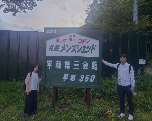


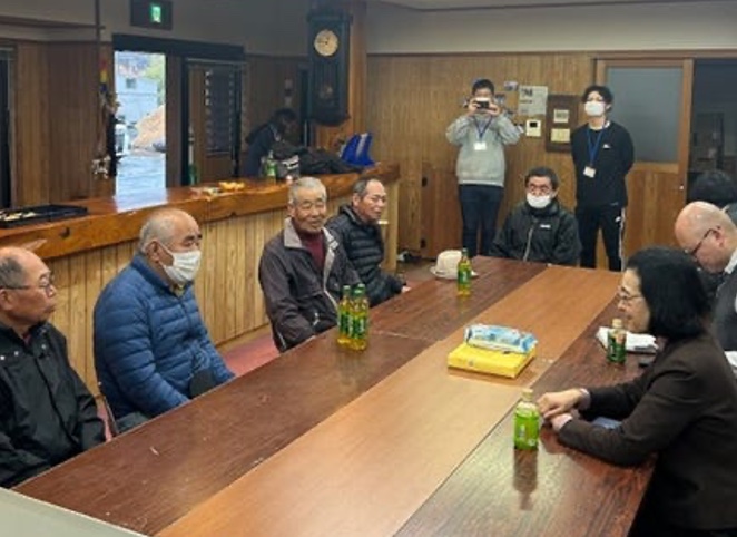
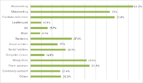

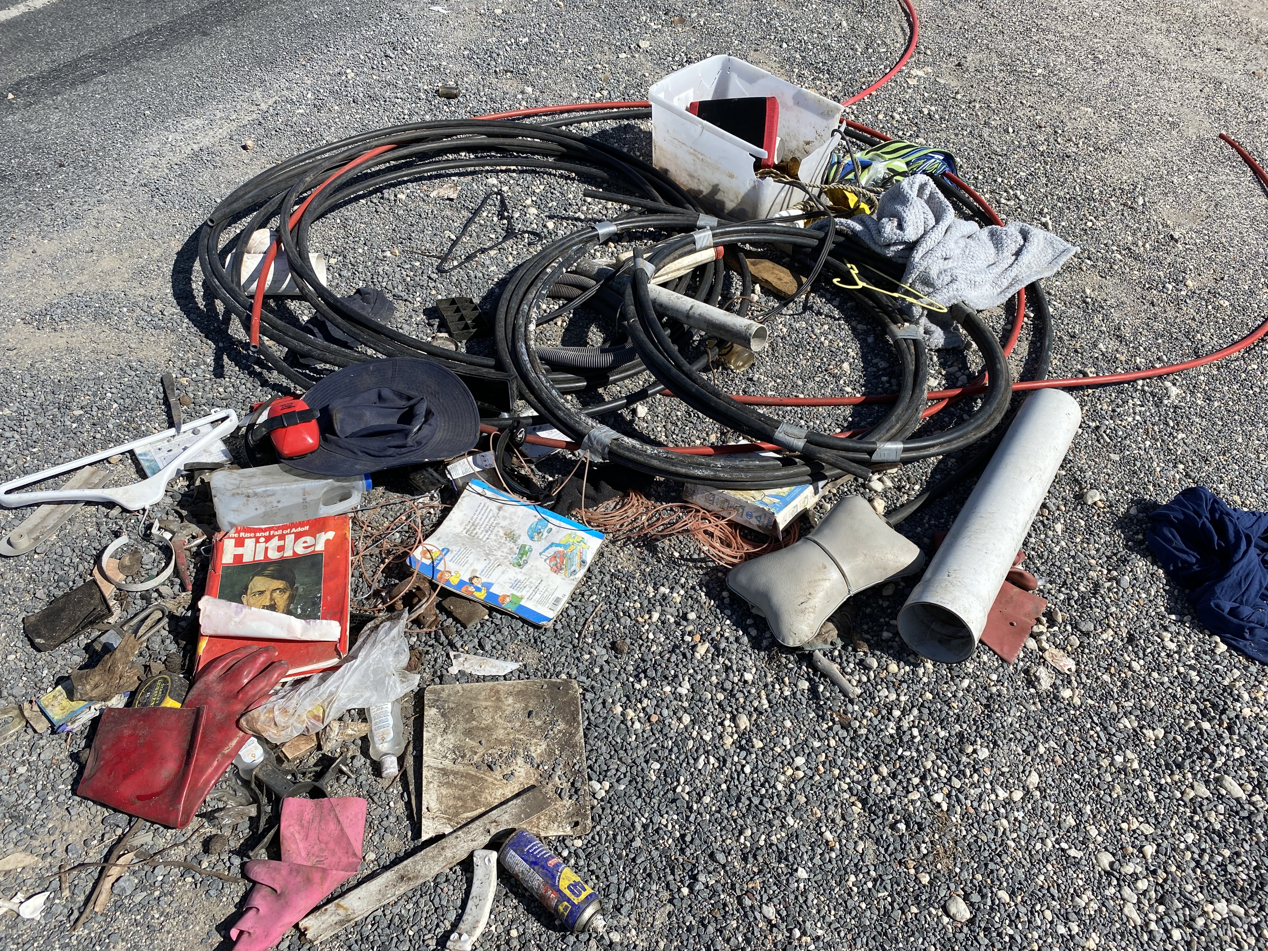


You must be logged in to post a comment.