‘Peaks, Wetlands & Rivers’
Hepburn Shire Reconciliation Week
Tour Notes, 2020
Barry Golding, b.golding@federation.edu.au
The tour is a Reconciliation Week initiative of Hepburn Shire Council.
- Hepburn Shire Reconciliation Action Plan Advisory Committee (RAP AC)
- Donna Spiller, Arts Culture & Reconciliation Officer Hepburn Shire
- Uncle Ricky Nelson – Dja Dja Wurrung Elder
- Barry Golding – RAP AC
- Inga Hamilton, Community Development Officer, Hepburn Shire
- Peter O’Mara – RAP AC
Why a virtual tour in 2020?
We originally planned to run ‘Peaks, Rivers & Wetlands’ as another ‘on Country’ bus tour during National Reconciliation Week 2002, 27 May to 3 June.
We conducted several days of planning in the field to make the experience of being on Country special. We deliberately chose three sites that participants and other members of the public would be able to later, independently access, enjoy and explore:
- Mount Greenock Geological Reserve, at Dunach
- Merin Merin Swamp, at Eglinton north of Clunes
- Hamilton’s Crossing at Neereman, north of Baringhup
Due to the COVID-19 pandemic we were forced to come up with a Plan B at very short notice. Our filming and recording had to be undertaken with great care for the safety of those involved, with low technology, low cost and limited time frames.
Sincere thanks
Our sincere thanks to the RAP AC members and others listed above. A note of gratitude to Inga Hamilton, our filmmaker/editor for skilfully and generously collating what we were able to film on-site and overlay with studio recordings. We are grateful to Donna Spiller and Inga for the huge amount of work ‘behind the scenes’ to film, edit and get the three You Tube programs and ‘Welcome to Country’ to completion.
Barry Golding penned these notes to share with anyone who views the programs and is interested in knowing more or physically visiting the sites.
These notes have been made accessible for download as a blog on Barry Golding’s www.barrygoanna.com website via shortlink https://wp.me/p3nVDL-t1
Reconciliation Week Virtual Tour Overview
Presented by Hepburn Shire Council in partnership with Jaara Elder, Uncle Ricky Nelson and Professor Barry Golding AM. Truth telling and reconciling our shared history at contact in the three-part series ‘Peaks, Rivers and Wetlands’.
Time travel back 180 years to three seldom visited environments and events from the early contact period that marked the beginning of unimaginable loss and trauma for Dja Dja Wurrung people. Join Jaara Elder, Uncle Ricky Nelson and Professor Barry Golding as they stand together on the top of the iconic volcanic slopes of Mount Greenock. Explore the tranquil Merin Merin Wetland where kangaroos still graze and visit the deep pools on the Loddon River at Neereman, where traditional owners once camped and fished for Murray Cod.
Welcome to Country – Feel the spirit of Country as Uncle Rick Nelson welcomes you on to Dja Dja Wurrung lands, to commence your Tour of ‘Peaks, Wetlands and Rivers’. https://youtu.be/ERIkKIORQ98
‘Peaks, Wetlands and Rivers’ = PART ONE Mount Greenock – https://youtu.be/5aav2w6gNyk
‘Peaks, Wetlands and Rivers’ – PART TWO Merin Merin – https://youtu.be/qmfhOxb2pAM
‘Peaks, Wetlands and Rivers’ PART THREE – Loddon River at Neereman – https://youtu.be/vaL4YnMmfcU
About National Reconciliation Week – 2020
Theme (appropriately) ‘In This Together’
https://www.reconciliation.org.au/national-reconciliation-week/
Reconciliation is a journey for all Australians – as individuals, families, communities, organisations and importantly as a nation. At the heart of this journey are relationships between the broader Australian community and Aboriginal and Torres Strait Islander peoples.
We strive towards a more just, equitable nation by championing unity and mutual respect as we come together and connect with one another.
On this journey, Australians are all ‘In This Together’. Every one of us has an essential role to play when it comes to reconciliation as we collectively build relationships and communities that value Aboriginal and Torres Strait Islander peoples, histories and cultures.
When we come together to build mutual respect and understanding, we shape a better future for all Australians.
This year Reconciliation Australia marks 20 years of operations in shaping Australia’s journey towards a more just, equitable and reconciled nation. Much has happened since the early days of the people’s movement for reconciliation, including greater acknowledgement of Aboriginal and Torres Strait Islander rights to land and sea; understanding of the impact of government policies and frontier conflicts; and an embracing of stories of Indigenous resilience, success and contribution.
2020 also marks the twentieth anniversary of the reconciliation walks of 2000, when people came together to walk on bridges and roads across the nation and show their support for a more reconciled Australia. As always, we stand on the shoulders of those who came before us, and Australians now benefit from the efforts and contributions of people committed to reconciliation in the past. Today we work together to further that national journey towards a fully reconciled country.
Throughout this time, we have also learnt how to reset relationships based on respect. While much has been achieved, there is still more work to be done and this year is the ideal anniversary to reflect on how far we have come while setting new directions for the future.
What is National Reconciliation Week?
- National Reconciliation Week (NRW) is a time for all Australians to learn about our shared histories, cultures, and achievements, and to explore how each of us can contribute to achieving reconciliation in Australia.
- The dates for NRW remain the same each year; 27 May to 3 June. These dates commemorate two significant milestones in the reconciliation journey— the successful 1967 referendum, and the High Court Mabo decision respectively.
- Reconciliation must live in the hearts, minds and actions of all Australians as we move forward, creating a nation strengthened by respectful relationships between the wider Australian community, and Aboriginal and Torres Strait Islander people.
The three sites in brief
The three sites featured in the virtual tour programs include public land that enables you to safely and sensitively access them, as below. All sites are reasonably distant from towns and none have services such as water or toilets.
Please note our safety cautions. Some notes are added, below, to help you find the sites, plan and enjoy your visit. All sites would be ideal on any mild, sunny day (not Total Fire Ban). If you visit Neereman or Merin Merin, note that both are water ecosystems and are therefore more likely to be home to snakes in season.
We include detailed access information for each site, as Google Map-type applications won’t necessarily recognise the sites and might lead you down some rough ‘goat tracks’.
The Mount Greenock and Merin Merin sites are around 50km from Daylesford (via Clunes) but only around ten minutes driving distance apart. If you have the time and interest, visiting both these sites while in the same area would make sense.
Hamilton’s Crossing at Neereman is around 40km north-east of the other sites (via Carisbrook) on the Loddon River (and approximately 60km north of Daylesford via Baringhup), but is well worth visiting separately for its beauty, giant river red gums and riverine habitat quite apart from its Aboriginal Protectorate association.
- Mount Greenock summit involves a steep and rocky walk up an exposed, windswept, treeless mountain flank, but with superb views.
- Merin Merin is an expansive shallow swamp ringed by regenerating tree and shrub vegetation and some ancient remnant trees.
- The former Neereman Aboriginal Protectorate is located on a very beautiful section of the Loddon River. It is a great place to appreciate nature and to swim in summer.
Mount Greenock

Mount Greenock is (today) an almost bald and reasonably steep, rocky former volcanic cone. The views from the flanks of the mountain and from the top and on a good day, are superb. Anticipate a windy (sometime cold) site and a steep, strenuous, rocky walk up to the memorial cairn towards the summit without well-defined tracks. Dress accordingly and wear strong shoes with a good grip. A grazing licence currently allows cows to graze on what is classified as a ‘Geological Reserve’.
Access
Mount Greenock Geological Reserve is actually on a large, approximately rectangular block of public land that includes the mountain and its crater partly bounded by several roads: see outline in red, below.
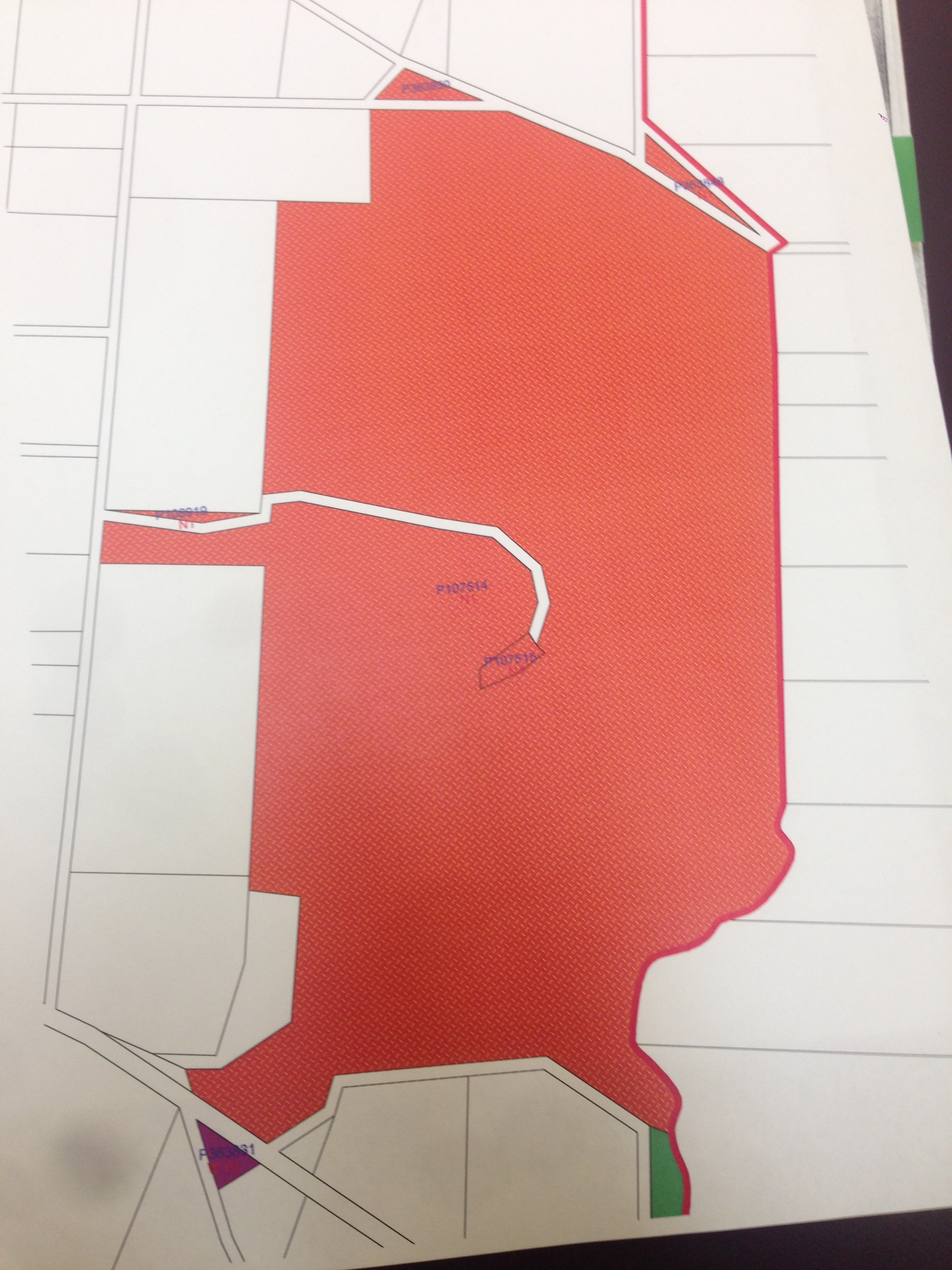
However, the only recommended safe access to the mountain is via the Union Mine site just off the Ballarat to Maryborough Road.
- If coming from the south, you will travel via Clunes. If coming from the north you will travel via Talbot.
- There is a Parks Victoria sign on the east (right) side of the road approximately 12 km north of Clunes (or around 6km south of Talbot) that says, ‘Union Mine & Mount Greenock Geological Reserve’.
- A short track off the road near the sign leads to a gate. Open the gate and drive in (close the gate behind you).
- Drive approx. 200 metres along a gravel track and park under the young gum trees near where there is a Major Mitchell display (with quartz gravel heaps from the former Deep Lead mine site alongside) and Mount Greenock right in front of you.
When you arrive, you will likely ask yourself, “Am I actually allowed in? The short answer is, “Yes. It is a public reserve.” However please avoid the grazing stock (and cow pats), leave nothing behind and take only your memories of the incredible vistas away.
The walk to the summit and the Major Mitchell cairn
If the access gate is locked you will see a wooden stile up the slope to help you cross a barbed wire fence onto the huge paddock that includes the mountain (and usually the grazing cows). Keep to the right around the rocky ridge immediately in front of you, and then pick a cow track (or any route that best suits you) to head up the steep, rocky slope towards the summit. To avoid the steepest climb, we suggest you keep to the slightly gentler slope towards the left. Once onto the broad crater rim, head for the big stone Major Mitchell cairn (a smaller rocky cairn is on the furthest edge of the crater). Wander and enjoy the 360-degree views!
Take care walking back down the slope to avoid slipping. Pick your way down the gentler slopes back to your car. Take care driving out onto the busy main road and shut the gate behind you.
Like us, you will probably ask yourself whether cattle grazing is an appropriate use of a publicly owned, iconic mountain in 2020. Maybe if more people knew about Mount Greenock something might be done in the future to remove grazing, sensitively revegetate the landscape, make its steep slopes less prone to erosion and make it more accessible for people to visit and enjoy. This might include interpretation other than about Major Mitchell that includes its important Dja Dja Wurrung connections.
For those that are interested in nature
From the broad summit on a good day you can see a vast swathe of country. The areas that are volcanic grassland now were largely grassland or open woodland in 1836. The main grass on the slopes would have been kangaroo grass and there were lots of silver banksia and buloke in the slopes of the mountain and volcanic grasslands. The areas of native forest now were largely forest in 1836. There are virtually no trees and only a few hardy native species on Mount Greenock, including the thorny Tree Violet bush (Melicytus dentatus) which clings on in rocky clefts despite the grazing.
You will see a broad volcanic crater breached towards the north east. The rocks are mostly scoria and vesicular lava (with gas bubbles). Some rocks are so full off gas bubbles they will float on water. The original ‘ropy lava’ flow structures are still evident in many of the rocks at the surface.
For those who are interested in post-contact history
The deep lead (Union) gold mine where your car is parked tapped into the gold bearing volcanic gravels that run right under the mountain (the Mount Greenock Deep Lead). The water worn quartz gravels were piled up as refuse as the finer gold bearing material was processed. From the summit you will see white spoil heaps of former mines on the same deep lead heading south towards the Great Dividing Range.
The following is a brief post contact history summarised from the file on the mountain still in the Epsom (Bendigo} Crown files office.
- The mountain and surrounding area would have been part of the Dunach Forest pastoral run during the 1840s.
- On 9 Nov 1863 the Lands and Survey Office decreed that the area to be added to the Talbot’s United Town and Goldfield Common.
- Gold mining during the late 1800s followed the Mount Greenock Deep Lead right under the mountain, extending several kilometres north and south. The white peaks on the south side of the Mount Greenock (below)are where shafts pierced the flanks of the mountain.

- By July 1894 it had been decreed that 360 acres be withheld from leasing and licensing.
- The Major Mitchell monument was erected with huge fanfare and re-enactment in 1936 to celebrate the ‘Centenary of Discovery’.
- On 17 March 1992 the mountain and 138 ha around it was declared as reserve, specifically for conservation of an area of scientific (geological) interest, consistent with the Land Conservation Council 1981 decision to zone it N1 ‘Geological Reserve’.
- By 1997, the main use pf the reserve was for grazing, at which time it was described as ‘very rocky, steep country’.
- A 2004 map shows Mount Greenock’s old geodetic trig (survey) point and rock cairn to north, and the Major Mitchell Monument to the south.
- A 2006 Survey Report wrongly concluded that ‘There is no evidence of previous Aboriginal occupation’ on the Reserve.
- There is an easement for an unused and unmade road from nearby Mitchell Road to the monument. Mitchell’s Road was not named after Major Mitchell, but after William Mitchell whose name is on a 40-acre original title to the NW of the reserve.
Merin Merin Swamp
Merin Merin Swamp is a hidden wetland gem now in public ownership around 10km north of Clunes ‘as the crow flies’, but we strongly suggest you follow the all-weather access directions, as below. Being a Game Reserve, you will definitely not take your dog.
Access
The recommended all weather access (including some gravel) into and out of the site is as follows (NOTE: other tracks in, including via the Mount Cameron Road are prone to be boggy or rocky and require high vehicle clearance). Drive slowly and safely on the gravel roads. Again, respect all protected wildlife on the site, leave nothing behind and take only your memories away. Take clothing appropriate to the forecast weather, necessary water and food. Don’t walk on a day of Total Fire Ban.
- From Clunes, take the Ballarat-Maryborough Road, C287 north towards Talbot.
- At the locality of Dunach, take the right fork along C288 (the Dunach-Eddington Road) towards Carisbrook.
- After around 500 metres, turn right onto Fells Gully Road.
- After around 500 metres, turn left along Wattle Gully Road. This gravel road takes you up to the elevated wetland along the remarkable margin between the rich volcanic plains of nearby Mount Glasgow, and the adjacent native forest growing on the much poorer soils developed on much older shales and slates.
- Follow Wattle Gully Road for 4.4km until the intersection where you see the ‘Merin Merin Swamp’ sign (where Weathersons Road turns right).
- Park safely off the road near this intersection and walk onto the reserve via an opening in the fence at the corner near the sign. Where you enter is on the NW corner of the Reserve [NOTE: Return the same way you came in].
The Reserve is an approximate rectangle bounded on most sides by minor roads [Please note that two blocks of land (fenced in) to the south west of the swamp are on private land]. The Reserve is bounded by Wattle Gully Rd to the north, part of Weathersons Road to the west and Middle Swamp Road to the south.
The strap grafted tree in the program might take some finding, but it’s within easy walking distance in from where we suggest you park your car: around 200 metres east of Weathersons Road and 100 metres south of Wattle Gully Road.
The wetland area is prone to be inundated in winter and spring, so wear shoes that anticipate water and mud, and long pants that anticipate snakes. It’s reasonably firm and very enjoyable walking around the shore of the swamp lined by regenerating red gums. Total distance is approximately 5km right around the edge.
For those who are interested in nature
Merin Merin Swamp together with Middle Swamp nearby, receive water via localised runoff from surrounding volcanic scoria cones and plains. Both swamps are locally important due to their high wildlife value. Previous land use had been timber harvesting during the gold rush era and beyond and grazing until the grazing licence was removed in the early 1990s and the area was properly fenced. The area is now a State Game Reserve managed by Parks Victoria. Recent extensive planting of local native species on the margins of the reserve has begun to enhance natural regeneration.
This shallow freshwater marsh contains a combination of Woodland dominated by Eucalyptus camaldulensis (Red Gum) and Open-Sedgeland dominated by Juncus (rushes), Carex (sedges), and Eleocharis (spike rushes). The swamp contains high habitat values due to the mixed age classes of Red Gums present and connection to the west with State forest. There is a very high proportion of introduced species, particularly Phalaris (Canary Grass). This is due to the swamp’s long grazing history.
For those who are interested in post-contact history
There was extensive mining in the region from the 1860s (though not close to the Merin Merin Reserve) and most original red gums were cut to supply the huge amount of firewood and timber the mines and miners consumed. The red gums were more recently used as fence posts and firewood until the area was made a reserve in 1977. Sheep grazing was phased out and ended in 1980. The area was severely burnt in the 1885 bushfires.
A 1987 Ballarat College of Advanced Education Draft Management Plan noted that an Aboriginal ‘canoe tree’ remained in the middle of the swamp, and a midden (oven mound) site and shield tree were also present on the reserve. There are other oven mounds on private land west of the reserve.
In 1989, 20 allotments totalling 202 ha were bought back by the state government at total cost of $110,800, a process that commenced in the 1976 on the basis that the area was of considerable value to wildlife, both for local and resident birds and also for migratory and nomadic species. The map below shows which blocks were bought back in 1989.

Whilst in 2020 there are still two parcels of private land allotments towards the south west of the reserve, the original Parish Plan had 21 other parcels of private and of up to 50 acres that are now part of the 2020 reserve as well as three now closed roads.
In 2008 the area secured a Permanent Reservation of 324 ha for management of wildlife and preservation of wildlife habitat.
The current Game Reserve area was Zoned C5 as part of the Land Conservation Council zoning process along with Middle Swamp as a ‘a valuable part of a chain of swamps used by waterfowl’. Planting of native tree and shrub species in recent years has greatly improved the prospect of this being reinstated as an important wetland habitat on the elevated volcanic plains.
Neereman Aboriginal Protectorate
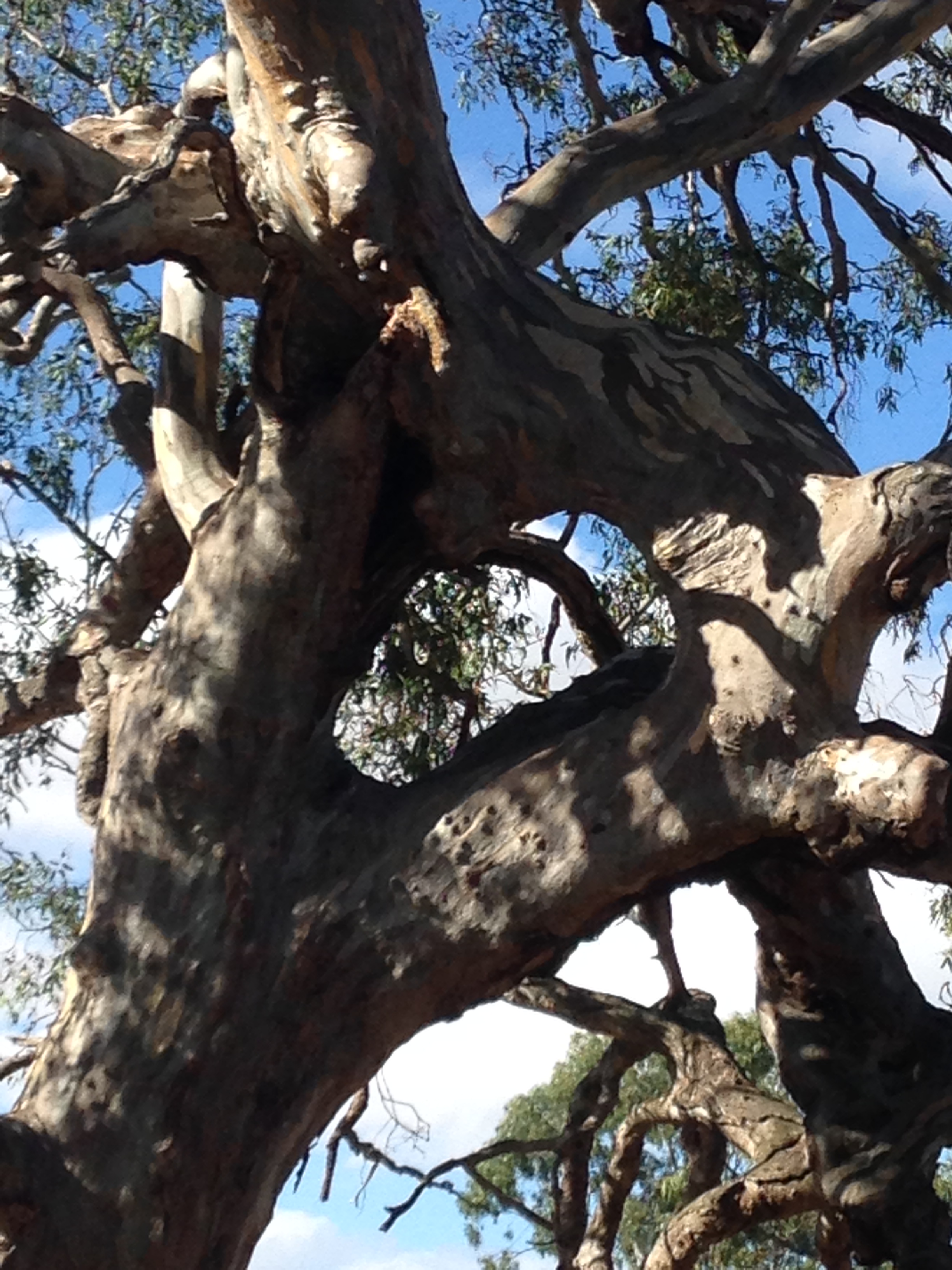
The images of the Loddon River at Neereman in the film show very old river red gums and long, deep pools at two sites. The site along the Loddon just upstream of the Hamilton’s Crossing streamside reserve, where the Uncle Ricky does the Welcome to Country under the huge strap grafted red gum (detail below) is beautiful. It is highly accessible and the one we provide access details for, below.

Hamilton’s Crossing is well within the original Protectorate site, and regularly used by locals and visitors. The site is also an excellent and very amenable place to swim, fish or bush camp.
Please NOTE: The centre of original 1840-1 Aboriginal Protectorate site that briefly included a ‘cultivation paddock’ is a few kilometers upstream of Hamiltons Crossing. It is only accessible through private property which we obtained for some of the Neereman filming. It should not be accessed for a range of good reasons: to do with its cultural and ecological importance, the currently fragile and erodible state of its steep cliffs and remnant vegetation, as well as its private status and the need to ensure the safety of its stock and crops.
Access
In summary, you are looking for ‘Hamiltons Crossing’, (not marked on many maps), right where the Baringhup West – Eastville Road (which you will find) crosses the Loddon River around 8km NW of Baringhup.
Make you way to Baringhup via either Newstead or Maldon. It’s a very spread out small town. From the Baringhup general store at ‘Loddon House’ (the only place for local supplies), head west along Baringhup Road towards Carisbrook, but turn hard right onto Baringhup West Road. There is a right turn after a few kilometers onto Baringhup West – Eastville Road which leads you to the (signposted) Hamiltons Crossing Crown Reserve where you will cross the ford over the Loddon River.
Park on the far (north) side of the Loddon River, and east (to the right) of the road. The river up or downstream is delightful and OK to explore as long as you don’t go through fences. The Loddon runs much of summer here and the gravel banks and pools make great places to picnic or swim.
The huge multi-stemmed, strap grafted river red gum tree featured in Uncle Ricky’s ‘Welcome to Country’ is upstream just a few hundred metres on the same side that your car is parked.
For those who are interested in post contact history
The centre of the former 1840-1 Neereman Aboriginal Protectorate (nominally 5 miles in diameter) is a few kilometres upstream of Hamilton’s Crossing on private land on long, deep pools in the Loddon River. The banks close to the waterline south of this wide and deep section of the river are lined with huge red gums. On the upper banks are a few remnant buloke trees. The flat and sandy area north of the river, where the ‘former cultivation paddock’ was marked in an 1856 survey, is still known as ‘Parkers Plains’ by some local old timers and has recently been irrigated by several huge centre pivot irrigators.
The river banks show no sign of the many wood and bark huts that were constructed for up to 200 Aboriginal people, Protectorate staff and families during the eight months that the Protectorate operated. Edward Parker’s son, Joseph Parker, writing in the Mount Alexander Mail in June 1916, recollected that in January 1840 his family had moved to ‘the large waterhole’ on the Loddon at Neura Mong, that he understood to be ‘the Aboriginal word for ‘hide here’ which also ‘proved to be the home of codfish’ (the Murray Cod).
Barry Golding recently found an entry to the word Neereman, spelt the same way, in an Aboriginal dictionary list from Coranderrk from 1909. Coranderrk was a government Aboriginal mission that operated in the post Aboriginal Protectorate era from 1863 and 1924, and to which several Dja Dja Wurrung people were forcibly taken from the Mount Franklin Aboriginal Station in the 1860s. The entry read: ‘Neereman (high bank; bend in river), Coranderrk, Vic.’
Historical Post script to Neereman
Barry Golding has recently transcribed much of the original hand written Aboriginal Protectorate correspondence relating to the selection, management and abandonment of the Neereman site. Some of it was graphically written by Assistant Protector Edward Parker on site. What follows is a summary based on original records. It seeks to explain why the Neereman site failed, and why it was moved to the better known site near Mount Franklin. As a warning, it’s not a pretty story.
1840 was an unusually (El Nino) dry year. The English seeds and potatoes planted in the cultivation paddock on the Neereman site wilted and failed in the sandy soil and harsh summer of 1840. The Protectorate Overseer, Richard Bazeley quickly determined that the Neereman site was totally unsuitable for cultivation. The food that had been brought up from Melbourne by cart was running out and Aboriginal people were starving and leaving.
The Dja Dja Wurrung people from many Clans to the north had been encouraged or forced to come to the site for their relative safety, but were forced back onto Country to find food. However they were also violently forced off the squatting runs, that by the late 1840 had total encircled the Neereman site. Grazing stock were eating out their staple grassland food, the Myrniong or Yam Daisy. Aboriginal people were also hunted down, arrested or killed if they interfered with the squatter’s sheep and cattle.
The Protectorate was only five miles in radius and unfenced from stock. There was much conflict over access to land, traditional food and water. Many Aboriginal people (and some squatters and their ex-convict shepherds) died in the surrounding area in the violence and murder that followed.
It was difficult or impossible for people from neighbouring Aboriginal Nations, some of whom were at enmity with the Dja Dja Wurrung Nation, to live peaceably and in such close contact on the Neereman site in the Christian harmony envisaged by Parker.
Many deadly introduced diseases were rife amongst the Aboriginal people of all ages living on or visiting the site by early 1841. A medical officer sent from Melbourne to inspect the Neereman site found syphilis was widespread and deadly amongst the women, spread mainly through regular contact between Aboriginal women and the squatter’s employees.
Meantime Overseer Bazeley scouted around for a suitable alternative Protectorate site where the soil and rainfall were better, and where there was less deadly interaction with the surrounding squatters.
Meantime the deep pools in the Loddon River at Neereman were fished for their huge Murray Cod and Maquarie Perch, which were dried and loaded onto a waggon. Carts were dispatched to Melbourne to try and obtain desperately needed flour, rice and sugar for the people who were starving.
The Aboriginal Protectorate at Neereman was finally moved from the Neereman site (despite further vehement opposition from the squatters) to a new site deemed more suitable on the flanks the of the Larnebarramul (Mount Franklin) volcanic crater in mid 1841. The Aboriginal Protectorate with Edward Parker in charge struggled on the new site for many of the same reasons.
The perceived advantages of the Mount Franklin cite (centred on present day Franklinford) included better soil and rainfall than at Neereman. It was also closer to Melbourne and had more thick forest on many of its margins, insulating it to some extent from the surrounding squatters, whose preference was for the former Aboriginal grasslands on the rich volcanic plains.
The Protectorate System was in tatters and politically unpopular with the squatters in the Port Phillip Colony by the late 1840s, and was abandoned in late 1849.
Edward Parker gave evidence to an official inquiry about the condition of Aborigines held some decades later. it also investigated why the Protectorate system failed. In Parker’s, opinion, the system failed mainly because he was not given enough support from the government to properly implement the Christian side of his civilising mission.
Brief personal reflection by Barry Golding
Anyone who has just read the disturbing post script, above, and who is concerned about First Nations reconciliation in Australia in 2020, will likely have many unanswered questions in their heads. We all need to keep asking and answering these questions, in collaboration with the local traditional owners, the Dja Dja Wurrung people and their descendants, for many years to come.
As a non-Aboriginal person living on Dja Dja Wurrung Country for most on my 70 years, I acknowledge the Traditional Owners of this land, past and present, and pay my respects to their Elders and ancestors, past, present and emerging.
I acknowledge the generosity, knowledge and wisdom of Dja Dja Wurrung Elder, Uncle Ricky Nelson. Working with Uncle Ricky on Reconciliation initiatives with the Hepburn Shire over the past few years has been a great joy and inspiration. I am delighted that two of the film clips are dedicated to Uncle Ricky’s late and great father.
In writing and reflecting on all this, I (Barry Golding) pose just one unanswered question,.
‘Why has the Neereman site and what happened here effectively been lost or forgotten in the ensuing 180 years?
