 Loddon Aboriginal Protectorate-Era (1840s) flour mill on The Mill Stream south of Franklinford
Preamble
One of the earliest water-powered flour mills in Victoria operated within the bounds of the Aboriginal Protectorate site south of Franklinford during the 1840s. This account seeks to consider previous and new evidence to establish where it was built, when and in what context. In doing so it seeks to distinguish between the Protectorate-era mill and a later, nearby flour mill from the Swiss Italian settler era of the 1860s. There is a case for this 1840s water-driven mill, perhaps one of the oldest in Victoria, subsequently being documented and recorded in the Victorian Heritage Register. I encourage anyone who reads this and has new evidence to support or refute my conclusions, to email me.
Other research underway on Victorian water powered flour mills
I note that Gary Vines has been actively researching all early water-powered flour mills in Victoria for a PhD at La Trobe University. Vines has been undertaking brief mill histories, mainly to try and track down where the millers came from. The main purpose of his research is looking at technology transfer in the mid 19th century. His hypothesis is that the nature of the technology introduced into Victoria was dependent in a large part to the particular background and knowledge of the individuals who came here.
It appears from Gary Vines’ research that a preponderance of Scottish settlers with experience of Lowland Manorial milling technology in Scotland influenced the form of early water mills in Victoria. In this context, the mills built by in the early 1840s by Hepburn and Joyce as well as the one on the Protectorate are a very important but poorly known part of Victoria’s white pastoral heritage.
The Protectorate era mill elaborated below was not on Gary Vines’ data base before August 2020, but Hepburn and Joyce’s 1840s mills were. Some of Vines’ preliminary findings are accessible via Google Docs https://drive.google.com/drive/u/0/folders/0B9cLyWT58-K8Zm1EX1EzZHprLXc. Gary has posted brief paper of early mills on the River Plenty: https://www.researchgate.net/publication/322737311_Mills_of_the_Plenty
Previous evidence
Edgar Morrison, in The Loddon Aborigines (1971, p.48) recollected that:
In the horse and buggy day … each Boxing Day a group of neighbours of all ages from Franklinford and Yandoit would congregate at the old Mill Spring about half way between Franklinford and Shepherd’s Flat [under] … the spreading willow trees that grew nearby. Near by a strong flow of crystal clear water issued from the hillside, forming a pool fringed with watercress. From thence, the water gurgled down the grassy slope before plunging into the Jim Crow Creek about 20 chains to the westward. … Since the earliest colonial days it has borne the name Mill Spring.
A generation ago the older citizens could remember carting wheat to an old Flour Mill, the wheel of which was operated by water from a race branching northward from the Mills Spring stream. … Fragments of the water-wheel are still discernible as well as a few crumbling walls of the mill itself. Yet before that structure was built, the spring had long borne its present name. … Gabriel Henderson (1854-1944) … attributed the name to the fact that ‘a small flour mill, operated by a water wheel was erected there by Mr Parker when he first came to the district’. An early survey map corroborates Mr Henderson’s statement. A position southward of the natural watercourse is defined as “Ruins of an old Mill”. At this time (1843-44) they used to grow wheat in what they called the Swamp Paddock – and ground it somewhere nearby. … One wonders what became of the two steel hand mills [Parker] had brought up from Melbourne in 1840. It is tempting to wonder whether the small flour mill erected on the Mill Spring race was in fact a combination of the old hand mills. …
New evidence
The new evidence, below, confirms much of what Morrison wrote. However, it appears that the ruins of a stone ground flour mill powered by water from the water race branching northward from the Mill Stream that Morrison refers to is different from and two decades later than what was likely a water driven, steel flour mill operated by Parker from a shorter race to the south of the Mill Stream.
On 28 November 1842 the Chief Protector of Aborigines, George Robinson visited the Aboriginal Protectorate on the slopes of Mount Franklin. Robinson wrote that he:
… visited the crater at the mount called Willum-parramul [‘place of the emu’], otherwise Jem Crow [Mount Franklin]. It is an ancient crater of large dimension. … Had a fine view. This morning visited the spring at the establishment a mile and a half distant. In the evening attended corrobery (sic.) of Malle condeets [literally ‘men of the mallee country’]. … At the conclusion both men and women singing together … After viewing … I went to the house. The Jajowrong had remained to a late hour.
This mention of Robinson’s visit to ‘the spring’ at the Protectorate and its approximate location approximately 1.5 miles from Parker’s 1842 house site suggests he had perhaps visited the spring on the Mill Stream rather than what is now known as ‘Thomas’ Spring’ on the flat near the current Franklinford Cemetery. On a visit five years later, Robinson mentions (in September 1847) that ‘the mill’ at the Protectorate station was out of order and that wheat being grown on the Protectorate was being sent instead to Hepburn’s mill (that operated from the 1840s on Birch’s Creek near Kingston).
In a December 1848 ‘Return of the number and condition of the buildings at the Loddon Aboriginal Station’ [Appendix 4 to Parker’s 1848 Annual Report: VPRS 4410(2)64, reproduced in Rhodes (1995)], the ‘Mill house, water wheel &c’ then comprised ”Partly sawn timber, partly slabs and bark’ and had been ‘Built last year [1847] – requires about 20 slabs to complete’,
John Hepburn’s mill is reasonably well documented. He had established his flour mill around 15 km to the west below present day Hepburn’s Lagoon near Kingston in 1841.
Gary Vines’ research reveals that the Smeaton district in East Lothian, Scotland, ‘ was an important centre during the Scottish Agricultural Revolution of the mid-eighteenth century, with numerous mills on the river Tyne, although these were associated with the cloth industry rather than corn milling. The Preston Mill was on the Smeaton estate, immediately opposite the famous engineer Robert Meikle’s Houston Mill. It is believed that Meikle maintained the Preston Mill at times. Meikle is also associated with John Smeaton. another famous mill engineer, so it is plausible that Hepburn named the station and subsequent town either for his Smeaton Estate in Scotland, or in connection with John Smeaton’.
Hepburn’s flour mill was still operating on 1 March 1860 when Captain Hepburn donated most of the prizes for the local Agricultural Society Show and allowed the use of the then three storey brick and stone mill for the occasion. Hepburn died five months later, on 7 Aug 1860. The mill declined and was abandoned during the 1860s and a new, much bigger mill (the current historic ‘Anderson’s Mill’) was built on Birches Creek at Smeaton by the Anderson brothers, using the same water source from Hepburn’s Lagoon via Birch’s Creek.
The new evidence available on the Protectorate suggests that by 1850 Assistant Protector Edward Parker or a contractor was operating the flour mill as a private business. Parker appears to have been doing similarly with a Lime Kiln, also established during the 1840s next to present day Limestone Creek, again within the footprint of the Aboriginal Protectorate.
Parker was questioned in 1853 about the financial and other arrangements in place on his Mount Franklin Aboriginal Station, established after the Aboriginal Protectorate was abolished in December 1849. There was concern by 1853 that an Aboriginal Reserve of 50 square miles was ‘disproportionately large’ given that the area had become ‘very rich gold country’. There were suggestions that some portions ‘which, with the greatest advantage to the public and the least injury to the aborigines might be surveyed for sale’. Parker’s responses (reported in Council Papers, The Argus, 14 June 1854, p.6) include mention that he had:
‘… also supplied the [Aboriginal] establishment with flour and occasionally meat at prices fixed by the Commissioner of Crown Lands, being at his request, calculated merely to cover the cost of production. In 1852 the price of flour and meat was 2d [2 pence] per lb [pound] for the whole year’.
These responses suggest that flour was still being produced by Parker from a flour mill on the Protectorate in 1852, and that it was being sold back to the government. Separately, the government arrangement with Parker was that he was responsible for all of the costs associated with the sheep on his large pastoral property, but was entitled to profit from the wool he produced.
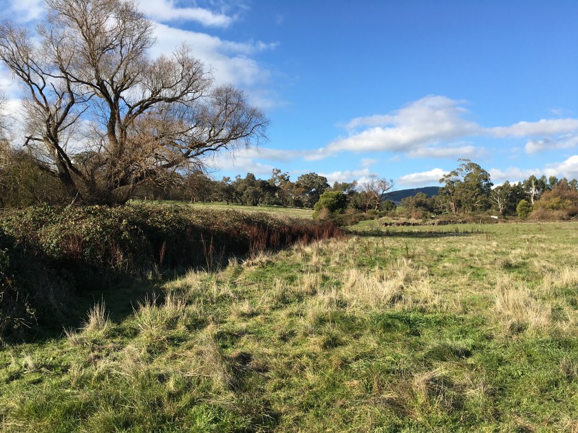
‘Mill Ruins’ downstream of the ‘Old Mill Spring’ are marked downstream of a water course and ‘Spring’ on an undated early survey map published by Morrison in 1971, approximately halfway between Franklinford and Shepherd’s Flat. The map reproduced in Morrison (p.49) clearly shows the location of the mill ruins and what appears to be a short water race leading south off the creek (marked on 2020 maps as ‘Bendigo Creek’) approximately 150 metres before it enters Jim Crow Creek. All of these features are marked within Allotment 4 of Section 6.
The site is today located west of the Daylesford to Newstead Road approximately half way between Franklinford and Shepherds Flat. In 2020 the surrounding agricultural land along the former Mill Stream (today marked on Google map as ‘Bendigo Creek’) is reportedly owned by a land developer. Bendigo Creek runs west under the road before it enters Jim Crow Creek, passing through a series of pools and a watercourse overgrown by blackberries. There is an unoccupied farm house and farm buildings on a rise south of where the water begins to pool.
A former water race to the north of the creek that originally led to a separate water driven, stone ground flour mill operated from the 1860s by Minotti and others is still visible on satellite images and on the ground. The longer northern water race appears to commence somewhat higher up the creek than a previously short water race south leading to a former 1840s Protectorate era mill.
On the ground, there is nothing exposed on the former 1840s mill site to indicate exactly where the mill might have been, though much of the area near the stream including several stone walls is overgrown with blackberries. However, some early survey maps show a sizeable pond dammed upstream of the likely early flour mill site that may have later supplied water to a north flowing water race. In 2020 the sound of water running over a rock barrier hidden amongst the blackberries is suggestive that part of the dam wall that may have fed the 1840s mill may still be in place.
Several large eucalypts are the only obvious remnants of original native vegetation. Most of the wet areas along the creek and former stone fencing are overgrown with willow trees and particularly blackberries. Watercress and other waterweeds cover part of the pool surface. The watercourse and associated pools reportedly lie within a public water reserve that extends along most of the creek west of the road. The water reserve boundaries appear to be delineated by broken down stone and wire fences. As a consequence, grazing stock (in 2020 including several horses) have ready access to the spring, pools and the creek banks. If this is a public reserve it appears that the adjacent landholder may possess or informally exert grazing rights over the area.
Eric Sartori (pers. comm., 31 May 2020) suggests that ‘Parker’s Mill was 10 chain down the flow, long before Pozzi and Minotti in 1865’. Sartori suggests, as evidence, the mention a former water powered flour mill in a letter penned by William Bumstead in the Mount Alexander Mail (8 April, 1859, p.5), which refers to a ‘Sale of Land at Franklinford’. William Bumstead then operated the store, post office and bakery in Franklinford in 1859 and was married to Charlotte Woolmer, a sister to Edward Parker’s first wife.
Bumstead’s 1859 letter expressed concern about the way gold mining, particularly the construction of water races, was adversely affecting the public interest. Bumstead was particularly concerned about the way miners had ‘… cut a race to bring them water from Allotment 4 of Sect. 6, through Allotment 3 of Sect. 6 to their claims a distance of near 2 miles, a great part of which is through solid rock.’
Bumstead proceeded to protest that:
Allotment 4 of Sect. 6 is one of the finest springs in the colony and ought not to be sold but to be preserved in perpetuity, for ever, for the public good. Think, Sir, for yourself, of a spring rising to the surface, running ten chains only, and then to drive a mill as this one has done, from whence it is named Mill Ruins Spring on Fraser’s survey, Parish of Franklin, County of Talbot.
The water-driven, stone ground flour mill known locally as Minotti’s Mill is approximately 400 metres NNW of the earlier Protectorate era mill site, powered from the same water source but coming north off the Old Mill Stream. David Bannear recorded and mapped ‘Minotti’s Flour Mill’ as a significant site associated with Swiss-Italian immigration for Heritage Victoria. The water wheel pit with remnants of the stone wheel and water race and associated buildings were recorded in some detail on allotments ‘PT21, 21A and PT58’ in 1998.
Bannear (1998) noted that this later mill was operated by Battista Monotti. The water was conveyed along a race to drive a 16 foot diameter waterwheel. Minotti operated the mill and perhaps the adjoining farm and gold mine with Guiseppi Pozzi. Bannear cites as historical information sources L. & P. Jones’ Flour Mills of Victoria: 1840-1890 and the Ballarat Courier (10 Oct 1868, p.21).
What flour milling technology might have been employed here during the 1840s?
One of the items of agricultural equipment procured by Edward Parker for use at the original Aboriginal Protectorate site located on the Loddon River at Neereman (6km north of Baringhup_ in late 1840 was a ‘Steel Mill’. Presumably this would have been a hand operated, steel flour mill. The History of Agriculture in South Australia website notes that the earliest wheat grown in South Australia was hand ground with such steel mills.
The first flour stone ground flour mill in South Australia was opened in 1840.
These early mills used stone rollers (mill-stones), imported mainly from France, with a barrel type sieving which only sieved off the bran. Steam power was mainly used, but there were some wind powered and water powered mills constructed with an isolated horse powered or bullock powered plant.
The upper and lower millstones were typically made of a siliceous rock called ‘burrstone’, an open textured porous but tough, fine grained sandstone, or a silicified fossiliferous limestone
Those used in Britain during the second half of the 1800s were usually either:
- Derbyshire Peak Stones of grey Millstone grit, used for grinding barley, or more often,
- French buhrstones [or burr stones], used for finer grinding, not cut from one piece, but built up from sections of rock cemented together, backed with plaster and bound with shrink-fit iron bands.
Several Millstones are mentioned amongst ship cargo coming into Australian ports during the 1840s. On 14 June 1841 (p.2) the Port Philip Patriot reported the arrival from Leith of ‘29 burr stones and one mill stone.’ On 1 Sept 1842, 28 burr stones were exported from Melbourne to Hobart amongst a cargo of sheep and flour on the schooner Truganini.
On 26 April 1841 the Port Philip Patriot reported that a very fine specimen of burr stone had been procured from Port Phillip, but that hitherto most burr stones had been procured from France. By 1844 the Maitland Mercury and Hunter River General Advertiser (4 May 1844, p.4) again reported that rock had been found near Melbourne that might suffice as a millstone:
BHURR STONE. This stone so valuable in the construction of millstone has been found in the neighbourhood of Melbourne. In texture and geological relations it is said to resemble the costly bhurr stone of France, for which, within the island of Great Britain, a magnificent reward was once offered by parliament.
During the late 1830s it appears that flour imported into Port Phillip came from mills in Tasmania or Sydney which were water or steam driven. On 29 Dec 1841 the Port Phillip Gazette noted that ‘a flour mill worked by water is in the course of construction at Coulstock’s station on the Plenty [River]’.
The best known early flour mill site in Melbourne was originally operated by John Dight of Campbell Town. He acquired portion 88, Parish of Jika Jika, County of Bourke, on 7 November 1838 on the Yarra River near Dight’s Falls. Over the next few years, he constructed a brick mill on the site and began the production of flour. In November 1843, ownership of the land passed to John Dight and his brother Charles Hilton Dight. In 1864, flour milling was abandoned and the mill was leased to Thomas Kenny. In the mid 1870s, the site was used by the Patent Safety Blasting Powder Co. The Dight family sold the mill site to Edwin Trennery in 1878 and he subsequently subdivided the land. The original mill on the river bank remained unoccupied until 1888, when flour millers Gillespie, Aitken and Scott, operating under the name of ‘Yarra Falls Roller Flour Mills’ constructed a new flour mill and associated buildings on the site.
There is a detailed account in A homestead history (pp.60-62) based on the letters of ‘Alfred Joyce of Plaistow and Norwood, 1843-64’ of a flour mill constructed by Alfred Joyce, a self-declared expert in ‘millwrighting and engineering’. Indeed Joyce completed a four year apprenticeship as a mechanical engineer and millwright. His apprenticeship indenture papers are dated 25 March 1837 (Joyce’s 16th birthday).
Alfred Joyce, whose homestead was on present day Joyces Creek, claimed in his letters that John Hepburn’s Smeaton Hill station was named ‘after the celebrated hydraulic engineer whom he greatly admired’, and that John Hepburn’s water-powered mill was powered with a ‘pair of real burr stones’ (p.60). John Smeaton (1824-92) was an English civil engineer responsible for the design of bridges, canal, harbours and lighthouses, who also pioneered the use of hydraulic lime in concrete. He also credited by some for inventing the cast-iron axle shaft for water wheels. However Hepburn’s reference to Smeaton is more likely about his birthplace by that name in Scotland.
Alfred Joyce moved to Plaistow in May 1844, setting up his run on Joyces Creek. Joyce noted that ‘turning the mill by hand was by no means a pleasant contemplation, but we had to go through it for a while until some mechanical contrivance was constructed’ (p.60). Joyce first attempted a wind-driven mill at Plaistow using ‘sails about nine feet across and fixed on the spindle of a small steel mill, fastened to a post that could be turned to the wind as required’. This contrivance worked well early on but ‘the uncertainty of the wind and its occasional violence’ led him to set up an undershot waterwheel on account of ‘little fall’. It was attached to two steel mills.
Given the likely short fall via a short southerly water race off the Mill Stream to the Protectorate mill site, the set up as described in detail by Joyce (summarised below) of a steel mill attached to an undershot waterwheel is the most likely one to have operated on the Mill Stream during the 1840s.
- Two very strong posts sunk in the ground four to five feet on either side of the water races, firmly rammed round with stones
- The shaft of the wheel made from dressed log 8 or 9 inches [approx. 20cm] through.
- The journals of the shaft comprising the well-rounded edges of the log reduced to about six inches [15cm] and running in corresponding dry wood bearings, these moving up or down in a long slot as the water rose or fell and supported on iron bolts passed through the posts.
- The lubricating material a mixture of tar or grease.
- A stout chain and grooved pulleys used to connect the power with the work as no other material would have stood the splash of the wheel.
Joyce’s neighbour Mr Bucknall (on Rodborough Vale run) first copied the wind mill and later set up an overshot water wheel in a copious spring coming out of the banks of the elevated plains’, also attached to two steel mills.
Given that Hepburn (from 1841), Joyce and Bucknall (from 1844) regularly passed through the Aboriginal Protectorate at Mount Franklin and sometimes stopped there on the way to and from Melbourne, and were on good terms with Edward Parker and family, it is likely that their expertise, experience and advice in flour milling might have been useful to those operating the Protectorate era mill. In the 31 Aug 1841 Protectorate report Parker noted that ‘about 35 acres of land have been enclosed and 13 acres prepared for cultivation, and five acres sown with wheat’.
As a postscript, once gold was discovered the need for flour milling increased exponentially. The foundation stone for a steam driven flour mill (Victoria Steam Mill) in Castlemaine was laid in December 1856. Many water-driven flour mills were also established across the goldfields towards the Great Dividing Range from the 1850s, wherever water was available to drive then.

Hi Barry,
I am researching water powered flour mills in Victoria and found your story on the Loddon Protectorate mill fascinating. I was wondering if you have inspected the site yourself, and if you have any photos of the likely site or Minotti’s mill to the north. I have placed some of my work in Google Drive – including a map of all the flour mills in Victoria. https://barrygoanna.com/2020/06/15/loddon-protectorate-era-flour-mill/
I would be interested in any further information you have on the physical remains of either of these mills.
all the best
Gary Vines
garyvines@iinet.net.au