The long tail of dispossession in Australia: Captains John and Robert Hepburn

 The long tail of colonialism in Australia: 

An interrogation of the family histories of two former Scottish sea Captains: Robert & John Hepburn

Barry Golding b.golding@federation.edu.au & Robert Hine

5 April 2020: minor edit 16 Sept 2020

Introduction 

What follows is our collaborative attempt to connect some complex family histories leading to Robert Hine (born in 1971) who lives in present day Tasmania. Our account illustrates how family histories become entwined with broader, often complex international and social trends, in this case with the long-term impact of slavery, colonialism and First Nations dispossession on two Hepburn family members who migrated from Scotland to become squatters on Aboriginal lands in Australia by the mid 1800s.

Our intention is to illustrate that Australian people have complex histories and multicultural heritages, in this case involving a West African slave on a Jamaican sugar plantation, Aboriginal Tasmanians, Van Diemen’s Land convicts, a Scottish folk hero and outlaw, as well as Scottish and English free settlers.

Some of the key individuals in our story include Captain John Hepburn (1803-1860), after whom the Hepburn Shire in Victoria, Australia (where Barry Golding lives) is named, and a cousin and also former sea Captain, Robert Hepburn born in 1782, around two decades before John and almost two centuries before Robert Hine. Our story and the family connections go back to Scotland, Africa and Jamaica in the 1700s, and unfold in Van Diemen’s Land (VDL, now Tasmania) during the 1800s.

This is our work in progress. We have drawn on a wide range of primary and secondary sources as well as oral histories, all of which are prone to error and inaccuracy. In Robert Hine’s words:

It is difficult to discover the true line of descent from family records and oral histories available today. Online ancestry sites can be inaccurate. There is also the possibility of some inbreeding in the original Jackson/ Pearce/ Hepburn line, and it is possible that some original documentation has been changed or substituted for close or fabricated records. We look forward to advice on what we’ve got wrong and what is missing.

 How this blog came about

Barry Golding has previously written about John Hepburn in his ‘Beyond Contact’ page on www.barrygoannna.com. He was prompted to research and write about Captain Robert William Hepburn by an unsolicited but welcome email on 8 February 2020 from Robert Hine. Robert’s email to Barry read:

Hi mate, haven’t read your [Beyond Contact blog] story yet, I will, but I just wanted to let you know I am a direct descendant of Captain Robert William Hepburn and his Daughter / granddaughter Jacobene or Jacobina. ‘Bene’ is what she went by. Married name Pearce. … I am Aboriginal through Jacobene’s daughter. I live in Hobart and while I can’t give you all the answers, as much history has been destroyed, I might be able to help you with stories passed down.

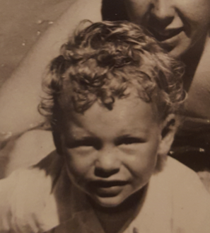
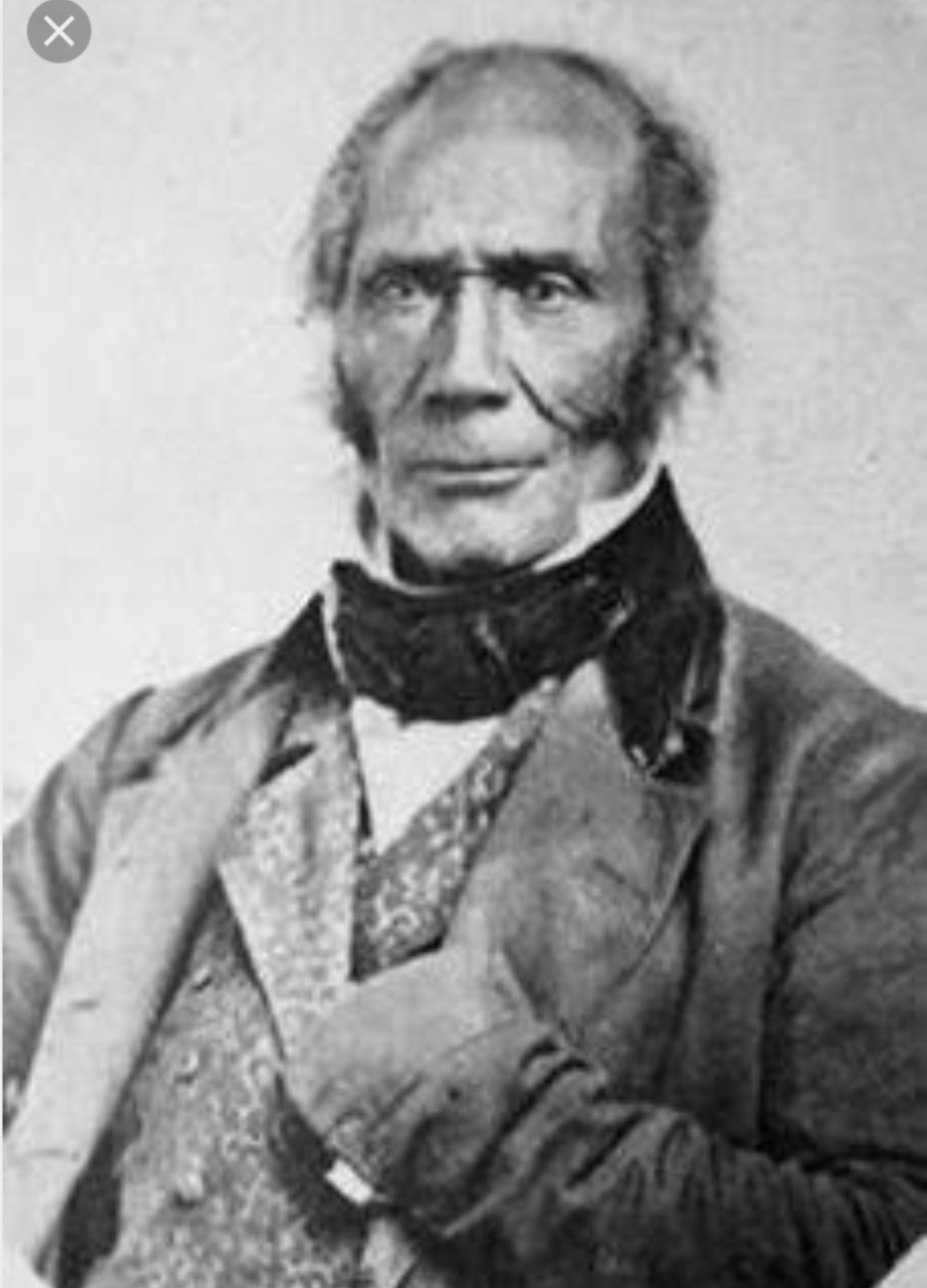
A follow up email from Robert Hine included a photograph of himself as a child, above, and a striking photograph, below, of Captain Robert Hepburn, that does not correspond to Lucille Quinlan’s claim of an unmistakable and persistent Hepburn family stereotype, ‘fair of complexion and blue-eyed, with hair that tends to wave crisply about the temples’, that appears in the opening paragraph of her 1967 book, Here my Home: The life and times of John Stuart Hepburn 1803-1860, master mariner, overlander, founder of Smeaton Hill, Victoria’about Robert’s cousin.

Background to John & Robert Hepburn’s Scottish ancestors

Lucille Quinlan’s book starts by painting a picture of ‘The Hepburn’s of Smeaton, Australia’ as descending from a long line of Hepburn’s of exalted calibres, including Scottish military heroes and lairds on huge estates. In fact the Australian Captain John Hepburn was the son of a Thomas Hepburn (1778-1857) a poor fisherman. John Hepburn’s reflected on his life age at 50, describing himself as ‘a mere adventurer cast upon the world since I was thirteen years old. For want of education, my progress was slow’.

John’s mother, Alison Stewart died when John was age four. It was John Hepburn who paid for his father’s tombstone in the Whitekirk, Scotland burial ground, curiously without his mother’s name but with the name of Agnes Whitecross, Thomas’ second wife. One of John’s much younger stepbrothers, Benjamin Hepburn (1826-88) emigrated from Scotland as a 23 year old to join John on the Smeaton Hill run in Australia.

When one puts ‘Smeaton Hepburn’ into a Google search in 2020, the’ Smeaton Nursery Gardens & Tearoom’ is one of the first listings.  The gardens, on the site of the likely former ‘Smyrton’ castle and later Smeaton Manor and Estate in East Lothian in Scotland, remains a working farm of 450 acres set in the Scottish countryside.

Prominent amongst the other ‘Smeaton Hepburn’ Google listings is the ‘Castles of Scotland’ website. It records that on the Hepburn Smeaton lands in the 1500s:

Adam Hepburn of Smeaton [was] supported [by] Mary Queen of Scots, and fought at the Battle of Langside in 1568, and is mentioned in a Summons of treason in 1567. Master Patrick Hepburn of Smeaton was a magistrate for the burgh of Haddington, and on a commission. … John Hepburn of Smeaton [in the 1640s] … was appointed as commissioner of the committee for purging the army within East Lothian. In 1661 Patrick Hepburn of Smeaton, Francis Hepburn of Beanston, and others, were on a commission for judging of Janet Hogg, spouse to George Harlaw in Linton, ‘guilty of the abominable crime of witchcraft’.

The original expansive Hepburn property in Smeaton, East Lothian passed by marriage to the Buchan’s when Elizabeth Hepburn, heiress of Patrick Hepburn of Smeaton, married George Buchan of Letham and the family took the name ‘Buchan-Hepburn’ from 1764. Their son, Sir George Buchan Hepburn, built the mansion in the 1790s. He was a lawyer and baron of the exchequer, and was made a baronet in 1815, four years before he died. Sir Thomas Hepburn-Buchan, 3rd baronet, was Conservative MP for Haddingtonshire from 1838-1847. The family held the property until 1934 when it was sold to the present owners, the Grays.

The very extended and dispersed family that Robert and John Hepburn were born into in the late 1700’s and the early 19th Century respectively had fallen on much harder times than this landed, privileged and knighted offshoot of the Hepburn family. In Lucille Quinlan’s words:

With the conquest of Scotland and England, the Hepburn fortunes declined. Then followed the agrarian and industrial revolutions and the long wars against Napoleon, with all their far reaching social consequences. The clan increased in spite of diminishing fortunes, so that more of the Hepburn’s were driven into renting small farms from richer cousins, or working at humble occupations in the villages around.

Both Robert and John Hepburn found a way out of the likely very limited local employment opportunities and went to sea for a living, both becoming sea captains, and adopting the title ‘Captain’. Near where Barry Golding lives in 2020 John Hepburn’s nautical legacy lives in the Captains Creek winery, Captains Gully Road.

As we will learn later in our account, it was the lure of the sea that had led several of Robert’s (MacGregor and Hepburn) forebears into rising through the ranks to become ship captains, including in the West Indian slave trave and the Royal Navy. By the time Robert and John rose to the rank of ship captains, slavery and the slave trade in North America was beginning wane, the military conflicts on the Iberian (Spanish) Peninsula had cooled off, and the new colonies in Van Diemen’s Land and Port Phillip on the other side of the world required ships to service them. They also provided the opportunity for many former ship captains with adequate capital to give up a lonely life at sea, spend more time with their wives and children and ‘take up’ huge acreages never dreamed of in Scotland.

In both cases, the land in present day Tasmania and Victoria was ‘taken up’ directly, sometimes with force and violence, from Aboriginal people. These acts of dispossession, which are still known euphemistically as ‘settlement’, were sanctioned by the colonial government. For very good reasons, neither John nor Robert documented what role they or their ex-convict employees actually played in this dispossession.

Some of this background helps explain how John and Robert Hepburn’s separate trajectories led them both go to sea and to later emigrate from Scotland and ‘take up land’. However it did not account for Robert’s complexion that was far from Anglo.

Robert Hepburn’s family background

Barry Golding looked at Quinlan’s one paragraph mention of Robert (p.17), describing him as a cousin of John Hepburn’s from Fife. As yet we are unable to identify their actual relationship, but it is clear that the areas in which they spent their childhoods was a reasonable distance apart. Fife is a Scottish county north of the Firth of Forth: East Lothian is the county to the South of the Firth. By road the distance between where Robert was brought up and John’s birthplace is around 60 miles (100 km).

Robert had settled in Van Diemen’s Land (VDL) for one year before John Hepburn sailed the Diadem up the east coast of Tasmania in January 1829. Quinlan described Robert as:

… a man of some substance, with sufficient capital to work the land, he had obtained the maximum government grant of 2,000 acres, situated on St Pauls Plains. Later he obtained 500 acres more to open a whale fishery at Oyster Bay … [Robert Hepburn was] very much a Hepburn in temperament and attitudes … and a reputation for having quarrelled with his neighbours and estranged members of his own family.

An online search confirmed that the St Pauls Plains area that Robert Hepburn farmed after he arrived from Edinburgh with his wife and eight children in 1828 is in the eastern Tasmanian Midlands close to the present day small town of Avoca. Hepburn set up a whaling station in 1829 at the foot of ‘The Hazards’, a mountain range now located within the Freycinet National Park on Tasmania’s east coast.

The Oyster Bay whaling station grant to Hepburn in 1829 included nearby Picnic Island that he used as a breakwater for his boat. The Oyster Bay Aboriginal tribe before this dispossession had frequented the island for many thousands of years, travelling across from the mainland in barks canoes or swimming. Their shell middens on the Western end of the island still contain the remnants of countless shared meals of seal, birds, crayfish, abalone, oysters, and other shellfish. When the whales weren’t running, Robert Hepburn would set his convict labour to work mining sandstone from the island.

 Barry Golding was prompted to look back into Robert Hepburn’s ancestry. The first surprising detail was his birthplace in ‘Wilkins Estate, St Dorothy, Jamaica’ on 28 January 1782. When he searched further he discovered that Robert was the ‘illegitimate son of Mary Ann Roy’ and son of Captain William Hepburn, born in 1738 in Scotland and who died in Fifeshire, Scotland ‘without surviving legitimate sons’ from his marriage to Penelope Willikin Newell. However there is a record of a daughter of William and Penelope, Penelope Newell Hepburn, born 13 years before Robert on 28 October 1769, who lived to adulthood and was Robert Hepburn’s half sister.

It transpires that the ‘illegitimate Robert by Mary Ann Roy (who perhaps died shortly after his birth) was given the Hepburn surname and sent to Scotland to be raised by his grandmother [Mary Olipher Hepburn, 1705-92] the widow of the Reverend Patrick Hepburn [1701-72] and after her death in 1792, by an aunt.’ Given that Robert’s father’s family were from East Lothian, it seems likely that being brought up some distance away in Fife might have been a deliberate strategy, given the then shame of illegitimacy, heightened by the fact that his mother was a young black slave.

Further searching revealed that Robert Hepburn’s mother, Mary Ann Roy, was born in Jamaica in 1766, daughter of Gregor MacGregor and a Jamaican sugar plantation slave, Isabella Diabenti. The Roy surname appears to have been taken from MacGregor’s forebear, Rob Roy MacGregor, a Scottish outlaw (1671-1734) in the ‘Robin Hood’ mould who became a Scottish folk hero. Gregor MacGregor (c.1742-1799) was a ship’s captain in the West Indian slave trade and son of Ranald McGregor (1706-1786). Rob Roy MacGregor was in turn Ranald’s father and therefore a great grandfather of Robert Hepburn.

Isabella Diabenti, whose African origin appears to have been ‘Koromanti’ in present day Ghana, was thus Robert Hepburn’s grandmother. Mary Roy would have been age no more than sixteen years when she gave birth to Robert. Koromanti (derived from the name of the Ghanaian slave fort Fort Koramantine in Ghana) was the English name for enslaved people from the Akan ethnicity from the Gold Coast in modern Ghana. Jamaican sugar planters used the term ‘Koramanti’ to refer to slaves purchased from the Akan region of West Africa.

The preamble in Robert Hepburn’s will, below, refers mostly accurately but somewhat hyperbolically to his proud outlaw and slave lineage.

This is the last will and testament of me Robert Hepburn of Roys Hill in the district of Fingal, Tasmania, Esquire, lineal descendant of my Father, Captain [William] Hepburn, of the family of Hepburn of Keith, East Lothian, Scotland, and my Mother, Mary Ann Roy, Great Grandson of Rob Roy McGregor, and by my grandmother Isabella, Princess of Diabenti, lineal descendant of the King of that nation of the Gold Coast of Africa. I am prince of Diabenti, King of that nation of Africa.

Robert Hepburn’s descendants

Robert Hepburn married Jacobina Hosie (born in Scotland 3 July 1884) on 18 May 1805 in South Leith, Edinburgh, Scotland. Jacobina and Robert had nine children between 1806 and 1824, eight of whom survived to accompany their parents to VDL / Tasmania following Robert’s retirement from the Royal Navy on 13 March 1827. Robert had been the Captain of a ‘revenue cutter’. The US Revenue Cutter Service (USRCS) was set up by George Washington to collect customs and taxes and to prevent smuggling.

Robert Hine suggests he was related to Robert Hepburn through Robert’s daughter, Lillias Hepburn, born in Scotland on 7 May 1817 and who died in Brighton, Tasmania in 1913 at the age of 96. Lillias married convict Matthew Frederick Pearce and had a daughter Jacobina Elizabeth Pearce.  Convict records show that Pearce had been transported from Liverpool, England, arriving in VDL on 14 January 1842.

Jacobena Elizabeth Pearce married William Isaac. Jacobena had a daughter, Mary Thelma Eliza Jackson born 23 Dec 1865. It seems that Mary’s biological father was not Isaac, but Captain George William Jackson who then worked then the prison orphanage. Not a lot is known about Jackson’s early life aside from being the son of Major J. S. Jackson, barrack master in Sydney who came to NSW in February 1823 in the Cumberland. In April 1831 George Jackson was appointed master of the cutter Charlotte, in which he made many voyages to the Aboriginal settlement at Wybalenna on Flinders Island. In September 1835 Jackson was appointed master of the Eliza, resigning to become a pilot in Sydney. There is evidence Jackson returned to Hobart from England in March 1846 in his wife and children. In 1846 Jackson was registered to the master and owner of the schooner Flinders.

Mary Jackson married William Joseph Bedford, son of Joseph Bedford and Sarah Briggs in 1886 in Pontville, Tasmania (As an aside, one of their six children was given the Christian names ‘Robert Hepburn’). Sarah Briggs (born with twin sister Fanny in 5 June 1833, died 28 January 1903 in Brighton, Tasmania, buried at St Marks Pontville) appears to be the Aboriginal connection to present day (2020) Robert Hine.

Sarah Briggs’ mother, Woretermotetey (given the English name ‘Margaret’) was born during the 1790s and died in 1841,  Margaret was the daughter of Mannalargenna of Plangermaireener Nation Pakana from Cape Portland, Tasmania.

Sarah’s husband was Joseph Leonard Briggs, born approximately 1808. Many Victorian (Koorie) and Tasmanian Aboriginal (Palawa) people have Briggs ancestry.

The University of Tasmania website entry for Mannalargenna suggests he:

… was about 55 years old when he met [George] Robinson on 1 November 1830 on the Anson’s Plain, inland from the southern end of the Bay of Fires. His country was Tebrikunna, now known as Cape Portland, in the far northeast of Trouwunna and he was the leader of the Pairrebeenne clan. Mannalargenna had four daughters and two sons and he is a direct ancestor of the majority of Aboriginal people in Tasmania today. Robinson considered Mannalargenna as being of ‘superior intelligence’, and there is no doubt that he was revered as a formidable warrior and seer amongst his people. He was extremely fond of smearing himself all over with grease and red ochre and he maintained his long locks of hair and beard with this material.

After losing his first wife he married Tanleboneyer who was one of Robinson’s early guides. Mannalargenna and his wife accompanied Robinson on his journey around the island from 1831 to 1835. He did not conform to Robinson’s wish to wear clothes and remained in his preferred ochred and naked state until he died.

Born about 1775 Mannalargenna had lived half of his life in a world of uncontaminated cultural traditions and the other half he experienced the full impacts of the British invasion. On the arrival of Robinson’s vessel to Big Green Island in October 1835 Mannalargenna cut the physical symbol of his role and status – his long ochred hair and beard. This seems to have been a final act in the face of his loss of connections to country and traditional practice. In the face of a life of exile in what his people believed were the islands of the dead. Mannalargenna died at Wybalenna [Flinders Island] on 4 December 1835 … Robinson attributed Mannalargenna’s death to him cutting off his long ochred and greased hair and claimed that this sudden change had led to catching cold and catarrh. As a final act of insensitivity Robinson buried Mannalargenna’s body on the burial ground in a coffin and allowed his enemies to participate in the service.

Robert supplied the following information on his complex ancestry during the most recent century.

I was born 7 April 1971 in Townsville Hospital according to my Birth Certificate. I have been DNA tested with my father, due to adoptions in the Bedford family, and if I wore a wig I would be a dead spit for my mother when she was a child. My mother was known by the name Maree Susannah Atkins (born 28th November 1939 at the Hobart Fire Station). But her real name was Maurie Susannah and her twin sister was Nancy, both were born on the 28 October 1939. Mum was secretly adopted by her aunt, Vildred Phyllis May Bedford. Her twin sister was secretly adopted by her uncle, Claude Hepburn Bedford.

Their real mother, my genetic grandmother, was Nancy Bedford, born in 1922 to William Robert Hepburn Bedford. William Robert Hepburn Bedford’s World War 1 enlistment papers describe him as of dark complexion and he was discharged as ‘not likely to become an efficient soldier’. This discharge reason was common with many Aboriginal or part Aboriginal soldiers in WW1. I share the same Grandmother as Tasmania’s most eminent Aboriginal photographic artist (Professor) Wayne Quilliam and his brother, contemporary Aboriginal artist Mick Quilliam.

Robert has spent much of five decades painstakingly uncovering and exploring his genealogy and cultural heritage. Some of the Aboriginal detail remained under the government ‘radar’ for very good reasons during two hundred years of Stolen Generations. Loss of identity for many Aboriginal children was a deliberate government strategy which started in Tasmania with white settlement and dispossession in 1803, became endemic everywhere in white Australia, and was only formally acknowledged with the National Apology in 2008. Robert Hine regards this process of reclaiming identity for himself and family as being a critical plank in national reconciliation. Mick Quilliam wrote in the Indigenous Law Bulletin in 2011 that:

Just as I was influenced by my grandparents and parents, I encourage everyone to explore their cultural heritage regardless of race. Ultimately, it is us who shape and influence our children in future generations so their identity is not lost. Encourage your children to explore, understand and appreciate their cultural background – be proud of who you are.

Robert Hine writes that:

I ran into Aboriginal Professors Marcia Langton (University of Melbourne) and Maggie Walters (University of Tasmania) at an Aboriginal shell necklace exhibition. I showed them a photo of my mother, standing with a group of other children. Both professors looked at each other and said, “That’s Cootamundra, your mother is a Stolen Gen child”.  Every time there was a family function, my adoptive grandmother, who I still regard as my grandmother, would say over and over again, “If anyone asks you why you have darker skin than them, tell them you are part Indian”. This was drilled into us. Perhaps it was due to my mum being taken, or due to the fact they were still taking children up until 1975 in Tasmania. The photo on the left, below, is my mother’s aunt to whom she was adopted, Vildred Phyllis May Bedford. The photo on the right below is my real (genetic) grandmother, Nancy Bedford.

In summary

Robert Hine’s ancestry, from our account, includes English, Scottish (Hepburn & Macgregor), African, English convict and Palawa (Aboriginal Tasmanian) connections and several adoptions.

Our account illustrates how revealing the truth about sometimes hidden or denied parts of our ancestry can help explain to our families and children who we are, where we come from, and what shaped the difficult decisions our very diverse forebears made. It is also, for Aboriginal and other Australians, an important and essential prerequisite to mutual understanding and national reconciliation. This is our intention for sharing this blog more widely with others.


‘Jim Crow Creek’ Information

Brief overview of evidence about the name ‘Jim Crow’ Creek

Professor Barry Golding AM

 b.golding@federation.edu.au

This is a very brief summary of what we know from the historical record about the origins and racist connotations associated with the naming of ‘Jim Crow Creek’ in the Central Goldfields of Victoria during the early 1840s.

A longer version with sources is also available by following this link, JemCrowAugustBG2019

I have added these documents to help inform the public about how our ‘Jim Crow Creek’ got its name, and to provide evidence that I believe argues for a process leading to a future name restoration.

Our local traditional owners, the Dja Dja Wurrung Aboriginal Nation, have requested that the offensive and racist name be changed for this significant, life-giving feature of their generously shared traditional lands.

‘Jim Crow Creek’ is a 26km long ephemeral creek, draining 123 square km of country, formed by the confluence of Sailors Creek and Spring Creek at Breakneck Gorge in Hepburn Regional Park, two kilometers north-west of Hepburn. A Streamside Reserve near Franklinford also shares the same name.

The creek flows in a northerly direction from steep, forested gullies to undulating grazing land and alluvial flats where it enters the Loddon River below the Guildford Plateau at Strangways, 8 km downstream of Guildford. As with other significant features in the local landscape, it had a previous Dja Dja Wurrung name.

The name ‘Jim Crow’ was likely first given to the mountain (previously known as Lalgambook,now called Mount Franklin) by squatter John Hepburn (or less likely Alexander Mollison) after April 1838. Its crater and the areas around it was also called Larnebarramul(literally ‘nest of the Emu’).

Later the creek, district, goldfield and, at times, the Aboriginal Protectorate, ‘Tribe’ and individual Aboriginal people were also called ‘Jim Crow’.

Part of Mollison’s run was called ‘Jumcra’ from 1840, on land that later become the Loddon (Mount Franklin) Aboriginal Protectorate from 1841.

Edward Parker, local ‘Protector of Aborigines’ used the term ‘Jim Crow’ Hill when referring to the mountain in his 22 September 1839 report.

‘Jim Crow’ was a widely used and racist, derogatory term used to describe black, mostly enslaved people in America in the 1830s.

A popular and catchy song ‘Jump Jim Crow’, sung in the 1830s by a black-faced US white minstrel negatively caricatured a clumsy, dim-witted slave. It became a huge hit with audiences worldwide.

An English poem similarly adopted and disseminated the US ‘Jim Crow’ theme to the British and colonial public from 1837. Called ‘The Jackdaw of Rheims’, it created a modern fable about how the crow (jackdaw) got its name ‘Jem Crow’. Again, the main character is a persecuted and dishevelled black crow.

The second last line of poem, above, makes clear, that empires, invaders and conquerors routinely bestowed new names on old geographical features.

George Robinson, ‘Chief Protector of Aborigines’ diary (14 Feb, 1840) noted ‘… a hill Mr Hepburn calls Jem Crow … on account of the small hollows about it’.

John Hepburn was previously a widely travelled international sea captain, including to the US. Like Mollison, by 1840 he would have been well aware of its racist connotations and familiar with both the popular song and poem.

The Jim Crow character in the song transferred to the now repealed ‘Jim Crow Laws’ that became part of several US state constitutions. The Jim Crow Lawsmandated the segregation of public schools, public places, public transportation, the segregation of toilets, restaurants, and drinking fountains for whites and blacks, in place from 1877 to the 1950s in the US. Understandably, in 2019 use of the term ‘Jim Crow’ is very offensive in the US.

The name of a former ‘Jim Crow Mountain’ and National Park near Rockhampton in Queensland was legally restored to Bagain Queensland in 2018 in collaboration with the Darumbal Aboriginal people and the local community.

There are other instances in Australia where similarly racist and offensive place names, such as ‘Nigger Creek’ have been officially expunged in consultation with the community and traditional owners as part of Indigenous reconciliation.

The Hepburn Shire and Mount Alexander Shire are actively engaged and supportive, with the traditional owners, in initiating a Reconciliation process to lead towards restoration of a more appropriate Dja Dja Wurrung name for the Jim Crow Creek.

‘Reading the Country at Contact’, Basic NAIDOC Tour Notes, 26 May 2019

Grounded in Truth: ‘Reading the Country at Contact’ Tour

Hepburn Shire Reconciliation Action Plan  (RAP) Tour Notes

A National Reconciliation Week 2019 Activity

Sunday 26 May 2019, 8.45am-4pm

National Reconciliation Week (NRW) is a time for all Australians to learn about our shared histories, cultures, and achievements, and to explore how each of us can contribute to achieving reconciliation in Australia. At the heart of reconciliation is the relationship between the broader Australian community and Aboriginal and Torres Strait Islander peoples. To foster positive race relations, our relationship must be grounded in a foundation of truth.

Join Adjunct Professor Barry Golding, and Dja Dja Wurrung Elder, Uncle Ricky Nelson for this one-day bus tour.

This tour invites you to experience a range of important sites in the Dja Dja Wurrung landscape where there is evidence of contact from the late 1830s between the peoples of the Dja Dja Wurrung Aboriginal Nation and the invading pastoralists, including John Hepburn, after whom the Shire is named.

There are seven stops, some as short as 20 minutes total time off the bus, so please follow instructions on the day to unsure we get to see all we planned. Most of our stops are on roadsides. To remain safe, please stay on the LEFT side of the road off the bitumen at each of these stops

ARRANGEMENTS: Registered participants will meet outside Daylesford Secondary College, Smith Street, Daylesford at 8.45am for departure no later than 9.00am. There is safe car parking outside the school. These tour notes with a route map (superimposed on an 1840s sketch map as well as an 1847 survey  map) will be provided on the bus. The tour notes prepared by Barry Golding that form the basis of the narrative during the tour will be posted after the tour in a ‘Reading the Country at Contact’ blog at www.barrygoanna.com

The two buses will return back to the starting point by 4.00 pm. We will visit, pass through or hear about a wide range of immediate post-contact sites that were significant between 1836 and 1841 in the Franklinford, Guildford, Strangways, Newstead, Neereman, Joyce’ Creek, Glengower, Campbelltown, Smeaton Plain, Smeaton, Kooroocheang and Kingston areas.

NOTE: All of what we see is on roadsides, ‘seen through the fence’, or in some cases with generous, one-off permission from landholders. Gaining permission for private entry on tours like this is a rare privilege.On no account should participants later trespass with others on private property or later contact private landholders to seek out what we look at from a distance.

PLANNED ITINERARY  (Please help us to keep to time …)

  • Board buses from 8.45am, Daylesford Secondary College, Smith Street.
  • Sharing of reasons for coming on the tour and expectations: on the bus.
  • 00am: Depart, travel towards Castlemaine, pass Mt Franklin (Lalgambook, withLarnebarramul volcaniccrater) to right; PASS second Protectorate site, June 1841-Dec 1849 to left).
  • PASS the Lime Kiln (on left), operating in the 1840s, supplied lime for John Hepburn’s House via the ‘Limestone Road’
  • Stop 1:30am: arrive at The ‘Big Tree’, Guildford, John Hepburn and family passed through here, April 1838.
  • 30 to 10.15am: Welcome to Country & Smoking Ceremony, Dja Dja Wurrung Elder Uncle Ricky Nelson; Welcome by Hepburn Shire Mayor, Don Henderson. Toilet available opposite the Big Tree.
  • Stop 2:45am-11.05am:The Loddon Valley at Strangways (considered but rejected as a Protectorate site, early 1841).
  • 15am brief Toilet Stopin Newstead & ‘Morning Tea’.
  • Stop 3:35am-12.00pm: The ‘Major’s Line’ October 1836 crossing on the Loddon at Newstead (later the Gold Escort route to Adelaide): Roadside stop opposite Mount Tarrengower, view towards Gough’s Range (Robinson & Parker reconnaissance trip, Feb 1840) and Neereman (Nov 1840-June 1841 Protectorate Site: 6km beyond Baringhup.
  • Stop 4:15am-12.35pm: Roadside stop above Joyce’s Creek opposite Moolort Plains, near remnant Buloke (Casuarina) trees to discuss the nature and importance of places where different ecosystems intersect.
  • Stop 5:55pm-1.25pm White Graves, the first burial associated with the 1840 Middle Creek Massacre, 1 km south of Campbelltown on Strathlea Road; narrative about Middle Creek, The Bloodhole’ 1840 massacre site..
  • 35pm brief Toilet Stop, Campbelltown Hall.
  • 45pm: PASS Aboriginal oven mounds (right) in private property woodland beyond Campbelltown fire station.
  • Stop 655pm-2.30pm: Roadside Lunch, Red Gums, Smeaton Plains, Williams Road, ‘A favourite place for the Aborigines’, described by G. A. Robinson in Feb 1840.
  • 40pm: PASSformerKooroocheang Swamp [private] (on right).
  • Stop 7:50pm-3.20pm: Hepburn Family Private Gravesite, off Estate Lane, below Mount Kooroocheang, [NB: Smeaton House is a private residence].
  • 3:30pm-3:40pm:Toilet Stop Smeaton Reserve
  • 40pm depart for Daylesford Secondary College, arrive by 4.00pm.

Map 1: March 1840 Edward Parker Rough Sketch Map, from E. Morrison, Frontier Life in the Loddon Protectorate, 1967, p.19. Most are pre 1840 sheep runs established mainly on the Coliban and Campaspe on Dja Dja Wurrung. When Parker drew the map he was likely unaware of the main branch of the Loddon. The ‘Polodyul or Loddon River’ shown is likely the stream called ‘Jim Crow Creek’ in 2019. Our tour route is marked in pink.

Parker Sketch Map 1840

MAP 2:  Main 1847 Base Map: copied from inside cover of ‘A Homestead History’(Reminiscences of Alfred Joyce 1843-64, Ed. G. James, 1942), redrawn from an 1847 Upper Loddon survey Map,

Upper Loddon Map 1847 (annotated 2019)

  • Our tour route is marked in pink; present day ‘towns’ in green; 2019 creek, river and mountain names added.
  • RUNS: Smeaton Hill(John Hepburn, from 1838); Glengower(Dugald McLachlan, from 1839); Plaistow (Alfred Joyce from 1843); Tarringower (Lauchlan McKinnon, 1839-41); Rodborough Vale (Thomas Chirnside 1839, Donald McKinnon then E. G. Bucknall from 1844); Boughyards (Alexander Mollison from 1837, Alexander Kennedy from 1840).
  • Note how quickly things had changed in the footprint of the current (2019) Hepburn Shire between 1840 and 1847.

‘Reading the Country at Contact’, May 2019, Extra Notes


Narrative for ‘Reading the Country at Contact Tour’

Hepburn Shire, NAIDOC Week Activity, 26 May 2019

Feedback and suggestions are welcome via b.golding@federation.edu.au

What these notes contain

These notes have been prepared by Barry Golding for tour participants to access later as a post at www.barrygoanna.com.  Further insights are provided on the site’s ‘Beyond Contact’ page and other posts.

These notes tease out Barry Golding’s tour narrative at the seven stops on the tour. There is also some narrative about places and sites we passed by between stops on the tour. Uncle Ricky’s important and complementary verbal narrative is not included in these notes.

Tour Rationale

  ‘to learn about our shared histories … [as an approach towards] reconciliation … grounded in truth’.

Tour invitation

…. to experience a range of important sites in the Dja Dja Wurrung landscape where there is evidence of contact from the late 1830s between the peoples of the Dja Dja Wurrung Aboriginal Nation and the invading pastoralists, including John Hepburn.

Tour Maps

The two base maps mentioned below, included separately in the tour notes, illustrate how quickly white invader knowledge of the ‘lay of the land’ in the footprint of the current (2019) Hepburn and Mount Alexander Shires improved between 1840 and 1847, as well as how quickly stations were created and new boundaries were established.

Map 1 (p.3 of participant notes): Parker’s March 1840 Sketch Map taken from E. Morrison, Frontier Life in the Loddon Protectorate, 1967, p.19, includes Hepburn’s (1838) run as well as earlier runs on the Campaspe and Coliban: including Mollison (1837), Orr, M[u]nro (1838-43), Thorn[e]loe & Ebden.

Parker Sketch Map 1840

MAP 2 (p.4 of participant notes) Main 1847 Base Map: copied from inside cover of ‘A Homestead History’(Reminiscences of Alfred Joyce 1843-64, Ed. G. James, 1942), redrawn from an 1847 Upper Loddon survey Map,

Upper Loddon Map 1847 (annotated 2019)

  • Our tour route is marked in pink; present day ‘towns’ in green; 2019 creek, river and mountain names have been added.
  • RUNS: Smeaton Hill (John Hepburn, from 1838); Glengower (Dugald McLachlan, from 1839); Plaistow (Alfred Joyce from 1843); Tarringower (Lauchlan McKinnon, 1839-41); Rodborough Vale (Thomas Chirnside 1839, Donald McKinnon then E. G. Bucknall from 1844); Boughyards (Alexander Mollison from 1837, Alexander Kennedy from 1840); Holcombe.

Travel towards Castlemaine

PASS Mt Franklin (Lalgambook) & Larnebarramul  (Mt Franklin crater) to right; PASS later Protectorate site, to left).

The main ‘Loddon Aboriginal Protectorate’ site was centred to the left of the road around present day Franklinford from June 1841-Dec 1848. Edward Parker was the Assistant Protector for the NW part of then Colony of Port Phillip. Hundreds of Aboriginal people (max 200 at any one time) lived or came here for safety, food and shelter whilst the Protectorate operated.

The central Aboriginal Protectorate area, radius ‘1 mile’, was for cultivation. A ‘larger 5 mile ‘radius (that went NS from approx. Hepburn Springs to Strangways, EW approx. to Glenlyon to Werona) was anticipated to be for traditional food gathering including hunting and fishing.

At the time the Loddon Protectorate closed only 30-40 Aboriginal people were living there. From April 1850 Parker was permitted to operate the Loddon station as a pastoral lease on the one square mile of land between Franklinford and the foot of Mount Franklin.  [often called the ‘Loddon’ protectorate (a) because the earlier (1840-1 Protectorate) was on the Loddon River (Polodyul or Pul-er-gil yal-loke) 30km to the NW, at Neereman 6km North of Baringhup, and (b) because the current ‘Jim Crow Creek’ catchments was sometimes called the ‘Loddon’, being part of the Loddon catchment).

The last of the Aboriginal people living at the ‘Loddon Aboriginal Station’ in 1863 were forcibly removed to Coranderrk Aboriginal Reserve near Healesville, which operated until 1924. In 2019 there are approx. 2,000 Dja Dja Wurrung descendants from around 20 apical ancestors who survived to the 1860s. Henry Harmony Nelson is Uncle Ricky Nelson’s apical ancestor.

To the right is Mount Franklin. Its peak was likely called Lalgambook. Its crater was usually referred to as Lar–ne-barramul, literally ‘place of the emu’, likely on account of the shape of its nest shaped crater. The original names are far from certain.

George Robinson first visited Edward Parker’s new Protectorate station site here (in June 1841) on 19 Nov 1841. He described it as being:

… on one of the sources of the Lodden (sic.), at a place called Willam.be.par.re.mal, a short distance from Lal.gam.book. The appearance of the place on approaching is rather pleasing; it is however surrounded by broken forest ranges containing abundance of game.

Robinson provides several variations of the Aboriginal name in his diary that same week. On 21 Nov 1841 he wrote that: ‘The hill at Loddon station is called Wil.lam.be.par.ra.mal(emu house). The creek or branch of the Lodden (sic) is called Lulgambook’.Robinson wrote on 28 November 1841 that he had:

… visited the crater at the mount called Willum-parramul, otherwise Jem Crow. It is an ancient crater of large dimension. … Had a fine view.

Hepburn climbed its peak soon after his arrival in April 1838 to get a better sense of the local topography. Called (and likely dubbed) ‘Jem Crow Hill’ by Hepburn, most likely because of a popular 1830s Poem, and 1830s minstrel song that referred to it as ‘Jem Crown’ and ‘Jim Crow’ respectively. It became Mount Franklin following a visit by former Van Diemen’s Land Governor, John Franklin in December 1843. The very negative, racist historic connotations of the term ‘Jim Crow’ arguably call for the original name of the Creek and the later name of the mountain (once clarified) to be restored.

PASS the Lime Kiln (on left),operating on the northern edge Aboriginal Protectorate of during the 1840s. It supplied lime via the ‘Limestone Road’ for John Hepburn’s mansion built in 1848-9. Likely the deposit was accumulated from as carbonate rich water from a mineral spring, colloquially referred to as ‘Limestone Spring’ or ‘The Bullfrog’ until it was tapped for spa water tanks built on the site in the 1980s.

STOP 1: The ‘Big Tree’, Guildford

 John Hepburn and family passed through here on the way to Kooroocheang, April 1838.

‘The Big Tree’: one of the largest Red Gums (Eucalyptus camaldulensis) in Victoria (height 32 metres; basal diameter 3m: age at least 500 years). It has a large branch graft on its northern side. The brass plaque records Burke and Wills camping here on their ill-fated northern expedition.

It is listed as a tree of State significance on the National Trust’s Register of Significant Trees of Victoria for its “outstanding size, curious fusion of branches, as an outstanding example of the species and as an important landmark“. The National Trust regards its conservation as vital to the local community and the State as a whole.

Due to its great age, numerous hollows have formed within the tree, providing habitat for many creatures. This tree is an eco-system which sustains a vast range of bird and animal life including magpies, rosellas, lorikeets, parrots, kookaburras, wood ducks, boobook owls, honey eaters, numerous species of insects, native bees and possums.

Already an ancient giant when the first white invaders arrived in the late 1830s, the Big Tree has played an important part in the cultural and social life of the Guildford community. This tree survives as an important symbol and a link between our community and its traditional owners, the Dja Dja Wurrung Aboriginal people.

John Hepburn likely camped nearby on his way to ‘take up his run’ around Kooroocheang in April 1838.

Welcome to Country & Smoking Ceremony, Dja Dja Wurrung Elder Uncle Ricky Nelson; Welcome by Hepburn Shire Mayor, Don Henderson.

STOP 2: The Loddon Valley at Strangways

This site was considered but rejected as a second Protectorate site in early 1841.

At this point we are on the fertile Loddon River flats. This was a former, important Aboriginal highway. To the south up the ‘Jim Crow Creek’ is a small amount of reasonably good volcanic soil that later became the centre of the former Loddon Aboriginal Protectorate. Opposite is the Guildford plateau, an elevated volcanic plain, which was grassland at the time of contact.

The current road between Newstead and Franklinford followed a narrow tongue of volcanic grassland that would also have been an Aboriginal highway between patches of forest on the older shales and slates.  These river flats are on the same highway that Thomas Mitchell crossed and camped at near present day Newstead in October 1836, later be referred to as ‘Mitchell’s Line’.

During 1837 several pastoralists used this river highway in to explore for new country to invade beyond already ‘taken up areas’. One group including Aitken (at Mount Aitken) swung up past Mount Macedon (Terawait) and Mount Alexander (Leanganook), along the Loddon and back to Corio via Ercildoune. Another group including Thomas Learmonth explored north from Buninyong, via Dowling Forest along the Loddon and back to Melbourne via Kyneton.

The huge quartz pebble to the right of the road came out of the gold bearing gravels on the edge of the Guildford plateau, an indication of how much bigger the stream buried by the basalt was several million years ago.

This area near the former Strangways railway yards (behind Don Hepburn’s house, perhaps a distant relation) became important in the early 1841 as Edward Parker looked for a Plan B right here as the original site at Neereman proved unsuitable. Lyon Campbell and other local squatters strongly objected. The objection was mainly because this area was already taken up by stations and was too close to what had become the main ‘overlanding’ highway on Mitchell’s Line between Sydney and Portland.

Uncle Ricky talks about the big picture of Dja Dja Wurrung people, the Clans, Moieties. Language and Kulin Confederations.

STOP 3: The ‘Major’s Line’

Thomas Mitchell’s October 1836 crossing on the Loddon at Newstead (later the Gold Escort route to Adelaide): Roadside stop opposite Mount Tarrengower.

View north towards Gough’s Range (Robinson & Parker reconnaissance trip, Feb 1840 and Neereman (Nov 1840-June 1841 Protectorate Site) 6km beyond Cairn Curran Reservoir & Baringhup.

We are now pretty much on the ‘Major’s Line’, one marked by the wheel ruts of the huge wagons as they headed back from Portland to Sydney in October 1936. A few days before he had climbed and named Mount Greenock near Talbot. Once of the volcanic plains he took a compass bearing to bring him out south of Mount Alexander, which took him north of Mount Cameron, through Strathlea to Newstead then through Expedition Pass near Chewton.

We know a lot about this area in 1840 because of the incredibly detailed (and accurate) diary records of George Robinson, Chief Protector of Aborigines (1839-1850) who came here through with Edward Parker in Feb 1840. They were loaned a cart by John Hepburn and ventured down from Hepburn’s Station via the Smeaton Plain, the Stony Rises (near ‘Tuki Trout Farm’), Campbelltown, and Joyce’s Creek to where it joins the Loddon (now beneath Cairn Curran Reservoir) and to Newstead. Below Newstead they described the still massive pools downstream that John Hepburn referred to in February 1840 as ‘the fishponds on the plains’ on account of the huge Murray cod and Macquarie perch in the big water holes downstream of Newstead.

They climbed to the western edge of a rocky range (now Gough’s Range) between Mount Tarrengower and the Loddon, ’20 miles north of Koretanger’ giving them a vantage point, Robinson describes the scene in detail on 21 Feb 1840:

Near to where we stood was the last of the Mameloid [breast-like] hills … red gums, sho oak [Allocasuarina], white gum, honey suckle (Banksia) trees. The low plains were mottled or carpeted with flowers in full blossom, patches from 1 to 2 acres of white everlasting flowers and then patches of an acre or more of yellow … or the beautiful blue flower with clumps of honey suckle and gums, and the pea green reeds of the Lodden (sic), like a broad green ribbon running in a tortuous line among the varigold and beautiful landscape, the glassy surface of the water shining between the branches of the trees.

To the north is Mount Tarrengower, (called ‘Salus’ by Mitchell), thankfully retaining its original name. Where there were no trees there was lots of Kangaroo grass. (Themeda). In many places on this Feb 1840 journey, typically on the edge between the woodland and the plain, Robinson noted many ‘bark huts of the natives’ and ‘ovens’. Just to the north of Cairn Curran Reservoir is Lauchlan McKinnon’s ‘Tarrengower’ Homestead.

Uncle Ricky talks about the relations between the Dja Dja Wurrung peoples, the explorers and the pastoralists.

STOP 4: Roadside stop above Joyce’s Creek (Knee-rarp) opposite Moolort Plains.

This stop is near remnant Buloke (Casuarina) trees, where we discuss the nature and importance of humans living in places where many different ecosystems intersect.

For the next 10 km we drive south along the eastern edge of Joyce’s Creek, a ‘lateral stream between the edge of the Moolort (volcanic) Plains and the Campbelltown Forest (on the old, rocky and relatively infertile Ordovician bedrock). Joyce’s Creek like the Loddon River, was then a well-travelled and settled Aboriginal highway. Robinson reported many camp, huts and ovens ‘where the natives had been’, with many freshwater mussel and emu shells. Robinson was ‘at a loss to account for the [immense number of] wheel and cattle tracks we now met with’ near Strathlea until he realised he was actually on the Major’s Line.

Uncle Ricky talks more about the food resources here.

This area was an ecotone: teeming with food resources in every direction: Emu, Kangaroo and Yam Daisy on the Moolort Plains; Murray cod and Macquarie perch in the massive pools in the Loddon downstream of Newstead to the north; possums and small mammals in the river red gums along Joyce’s Creek and forests to the east; rich fauna and flora in the Banksia and Buloke woodlands Blackfish and freshwater mussels in the creek; 30 large wetlands on the Moolort plains with a whole range of aquatic plants, birds, yabbies.

ON the way south the bald volcanic hills gradually come into view, Powlett Hill to right, then Moorooklye, Stony Rises and Kooroocheang to far left.

STOP 5: Graves associated with the 1840 Middle Creek Massacre

This stop is 1 km north of Campbelltown on the Strathlea Road.

The memorial grave is to the left of the road on private property. On the opposite (west) side of the road verge opposite the graves is a stand of unusual and inedible Osage oranges (Maclura pomifera)

A brass plaque on the grave displays the following text:

HERE LIE THREE UNKNOWN PIONEERS OF THIS DISTRICT.

A COOK ON GLENGOWER STATIONKILLED BY THE ABORIGINES IN 1840.

A TRAVELLER KILLED BY MIS-ADVENTURE BY THE STATION DOGS IN 1841.

AND A YOUNG EMPLOYEE,

DIED FROM NATURAL CAUSES IN 1841.

MAY THEY REST IN PEACE.

The three European people buried in the Pioneer Memorial Graves were all associated with the Glengower run. This spot was first used as a burial ground following an initial disturbing incident and burial by Dugald McLachlan in winter or spring of 1840, and again in 1841.

The third burial, unrelated to the violence associated with the first and second burials, is the grave of the young son of the original informant about the massacre story, Donald (‘Rhu’) McDonnell.

The first burial is that of a cook at the Glengower station who was killed by a band of Jadwajali Aborigines returning to the Grampians after obtaining greenstone axe blanks from Mt William, near Lancefield. The Aborigines are said to have called at the station for food when McLachlan and the stockmen were away mustering sheep for shearing, and only the cook was present in the cookhouse. The cook is alleged to have added Plaster of Paris to a damper he had cooked for the Aborigines, which once ingested would have caused a horrible and painful death. An altercation allegedly followed and the Aborigines are alleged to have murdered the cook, hanging his body in the cookhouse on a meat hook. When McLachlan returned he immediately organised a punitive expedition comprised of Glengower and neighbouring Smeaton Hill stockmen.

McLachlan buried the cook, whose name is not known, at the present gravesite only 800 yards north-east of the homestead. In expectation of a reprisal raid, McLachlan released his savage hunting dogs into the station grounds (he purportedly used for hunting dingo) after nightfall. About a year after the cook’s murder in 1841 the dogs, savaged to death an unnamed visiting itinerant traveller, who was buried beside the murdered cook. The third grave is of George McDonnell, the son of shepherd (and the original informant of the oral history) Donald McDonnell, who died of natural causes in 1841.

McLachlan was well known amongst his contemporaries as very hard and ‘austere’ man. He was very fond of using guns and hunting dogs. He was described as ‘austere’, grasping, ruthless and uncompromising of men and beast even by his contemporaries.

On Middle Creek, Glengower (on private land) is ‘The Bloodhole’, the site of an 1840s Aboriginal massacre that took place approx. 8km to the west.

The Aborigines thought to be those associated with the death of the cook were tracked down with McLachlan’s dogs and they hid in the waterholes on Middle Creek. On seeing the approaching men on horseback with guns, the Aboriginal men jumped into the creek to swim to the other side or hide under water. The mounted men from the station including McLachlan fired on the Aborigines in the water. Some had hollow reeds to breathe through while submerged, which still grow at the site today. By the time the firing stopped at least 12 Aboriginal men were dead and floating in the bloody water. The place (on private property) is still known locally by some residents as ‘The Blood Hole’ or ‘Slaughter Hole’.

STOP 6: Smeaton Plains, Williams Road (do NOT leave the road reserve and enter private land)

  ‘A favourite place for the Aborigines’, described by G. A. Robinson in Feb 1840.

Robinson writes on 14 February 1840 that being a fine and pleasant day, John Hepburn took him to the top of Kooroocheang. Hepburn then:

Showed me a plain with some open forest on it, 3 miles [5km] from his house in N [northerly] direction. Said it was a favourite place for the natives. He has seen 30 women on the plains at a time digging murrnong while the men went into the forest to hunt kangaroos, opossums, &c. which are abundant.’

After dinner that same day, being summer the evening would have been light. Robinson:

‘… rode out with Mr Hepburn to the place of the native camp aforementioned. Rode over some beautiful country. The Mameloid [‘breast like’] Hills has a natural appearance when seen from the plains. And so the hills in the distance than when viewed from the top of Koratanger. The trees from Kor.ra.tanger looked diminutive but when we came to them found them large, 2 and 3 feet diameter at the butt, with large umbrageous branches . Well covered with foliage, they stood at a distance of from 20 to 50 to 50 yards and the whole which was about half a mile square, had a park-like appearance.’

Robinson’s use of term ‘park’ to describe what was an Aboriginal Australian woodland was common amongst many British squatters and explorers familiar with parks created in the ‘old country ‘around country houses and estates.

The creators of this deliberately managed Australian park were still living and cooking underneath the trees in this 1840s landscape. Robinson continued:

‘We saw the remains of from 30-40 screens or shelters of boughs where the natives had been. Also several of the native ovens or fireplaces where they baked their murrnong. Some 10 feet in diameter. … Returned through another part of the native camp. Saw some more native huts or screens. Rode round the S end of Koretanger. The dogs killed a native cat, dark color and white spots’.

PASS former Kooroocheang Swamp [private] (on right).

Several oven mounds described by Robinson have been recorded in the vicinity the former Kooroocheang swamp. Jack Sewell recalls plentiful freshwater crayfish in the swamp before it was drained in the 1960s.

There are historic records of the Brolga (Grus rubicunda) nesting around the swamp, indeed the word Kooroocheang is thought to reference the brolga. ‘Turkey Hill Road’ north of Powlett Hill references the former Bustard (Ardeotis australis) common on the local grasslands before the introduction of sheep and cattle as well as  hunting. 

STOP 7: Hepburn Family Private Gravesite

This site must be accessed from a gravel car park on the south side of Estate Lane, below Mount Kooroocheang, Please note that Smeaton House nearby is strictly a private residence.

John Hepburn’s decision to replace his first timber house and commission a huge new, 20 room, double storey mansion was announced in his journal on 2 April 1849. That day his family had shared ‘a pleasure party’ with neighbours on the nearby Kangaroo Hills.

The Smeaton House mansion has for the past 130 years been the private home to the Righetti family. The mansion complete with verandahs on three sides of the lower storey, stables and a coach house was finished by the end of 1850, just before the first discovery of gold at nearby Clunes. Unsurprisingly, the mansion is highly classified by the National Trust but remains private.

The Hepburn family graveyard on a nearby picturesque knoll is now owned and maintained by the National Trust. There is public walking access across privately owned paddocks to the Hepburn Graves via a car park recently constructed south of the cemetery on Estate Lane. John Hepburn was buried here in 1860. The pallbearers at his funeral comprised the men of the Creswick and District Roads Board.

At the time of Hepburn’s death in 1860, just 20 years after Mitchell’s wagons rolled through this Dja Dja Wurrung landscape, the telegraph had arrived and the railway was advancing from Geelong towards Ballarat. The first 1851 gold rush in nearby Clunes was then only nine years old, but by the 1880s had spread for 100km in every direction and totally transformed the landscape and society.

Only three of John Hepburn’s ten children plus his wife Eliza (died 1869) are buried in the family graveyard: including the two children who came overland in 1838, Alice (died 1865) and Thomas (died 1859) as well as George (who was born at the property in 1838 and died 1903). Other Hepburns buried there include the family of John Hepburn’s brother, Benjamin who died in 1888.

Aside from the Hepburn family graves and inscriptions, the exotic trees within the fenced off cemetery as well as the views are sublime (on a fine, sunny day).

One view is towards Mount Moorookyle, another is towards Mount Kooroocheang. A third vista south overlooks the valley of Middle Creek, locally called ‘Captains Creek’, through scattered, remnant, ancient woodland eucalypts.


Mitchell ‘discovers’ Dja Dja Wurrung’s Australia Felix


Mitchell passed twice through Dja Dja Wurrung country in Winter and Spring of 1836. This account focuses on the implications of Mitchell ‘discovering’ the highly productive, carefully created, and responsibly managed Dja Dja Wurrung grasslands, that he otherwise took to be empty and ripe for subsequent picking by European invaders.

NOTE: Much of my account was added on 24 September 2018 to my much longer and wider historical and autoethnographic narrative on the ‘Beyond Contact’ page.

Major Thomas Mitchell’s 1836 traverse across what is now inland Victoria is important as part of the wider historical narrative by virtue of being the first European to describe and give (mostly new European) names to most of the inland rivers and mountains of northern and Western Victoria, including those rivers already mapped, named and cultured by Dja Dja Wurrung peoples for around one thousand generations.

Mitchell’s diary, published in Three expeditions into the interior of Eastern Australia; with descriptions of the recently explored region of Australia Felix and the present Colony of New South Wales, records his 1836 overland expedition of ‘exploration’ from Sydney via the Murray River then south to Portland, returning via Western Victoria and present day north eastern Victoria.

While Mitchell made some notes about the local traditional owners he encountered, his main interest was in describing, naming and ‘opening up’ a country’ he regarded as essentially uninhabited. That said, his 25 man official party including his second in command, G. C. Staplyton carried a total of 36 firearms. The men were dressed in red woollen shirts and grey trousers crossed by white braces, ‘giving the men somewhat of a military appearance’ (p.2) as they set off, in Mitchell’s words, ‘to traverse unexplored regions, peopled, as far as we know, by hostile tribes’ (p.3).

The expedition anticipated using boats along and in order to cross some larger inland streams including the Murray and Darling Rivers, which they carried in a boat carriage. The several heavy wagons left their wheel ruts discernable for several decades after their expedition. The track the wagons followed was often already an Aboriginal highway, and the expedition’s track across Victorian’s northern plains quickly followed by squatters, sheep and cattle later became known as the ‘Major’s Line’.

Twice during this 1836 expedition Mitchell passed through Dja Dja Wurrung country, twice crossing the Loddon River. The first traverse and river crossing was in mid winter (late June and early July, 1836) whilst heading southwest between Pyramid Hill and the headwaters of the Richardson River. The second time the expedition crossed the Loddon River near present day Newstead in late September 1836, on router between Mount Cole and Mt Alexander as the expedition was heading back towards Sydney. Mitchell named what is now known as Mount Alexander (to the Dja Dja Wurrung, Leanganook) ‘Mount Byng’, though the name did not stick. Admiral John Byng, an English Royal Navy officer was court-martialed and shot dead by a firing squad in 1757.

Unlike Chief Protector of Aborigines, George Robinson, Mitchell not only took the country to be uninhabited but also prepared and predestined for European intrusion by a then unknown cause. Mitchell came close to identifying the then unknown explanation for such extensive areas of open grassland on what later became the heavily grazed and cultivated plains of northern and western Victoria when he wrote that:

On highest mountains and in places the most remote and desolate, I have always found every dead trunk and the ground and any living tree of any magnitude also, the marks of fire; and thus it appeared that these annual conflagrations extend to every place. (p.328)

What Mitchell described were grassland, woodland and forest ecosystems carefully and deliberately created and managed by thousands of years of regular and systematic Aboriginal burning to encourage and sustain their desired food plants and animals.

On 30 June 1836 Mitchell was towards the north end of Dja Dja Wurrung country when he climbed to the top of Pyramid Hill and described:… a land so inviting, and still without inhabitants! As I stood, the first European intruder on the sublime solitude of these verdant plains, as yet untouched by flocks or herds; I felt conscious of being the harbinger of mighty changes; and that our steps would soon be followed by the men and the animal for which it seemed to be prepared’ (p.159).

The ‘fine plain’ Mitchell and his wagons passed across the next day was covered with what both he and Robinson called anthisteria, now known as Themeda triandra, ‘Kangaroo’ or ‘Oat’ grass, also covered in places by what Mitchell recognised as banksia and casuarina, and what Robinson respectively called ‘honeysuckle’ and ‘oak’. By July 5 they passed a lofty hill Mitchell recorded as Barrabungale (likely present day Buckrabanyule, unbeknown to Mitchell the sacred home of the feared ancestral giant serpent, Mindi). By July 6 the party were on a river Mitchell named the Loddon, because ‘… of its resemblance in some respects to the little stream in England.’ On July 10 they crossed and named the Avoca River, and on 13 July crossed and named the Richardson River after his botanical collector, John Richardson, who had an unplanned swim when his horse slipped during the river crossing. By July 19 they has encountered another river they ascertained from the locals to be the Wimmera.

By late August 1836 the expedition had passed north of (and renamed) Gariwerd the Grampians, and travelled along the Glenelg River, launching their whaleboat to explore the wide and navigable lower parts of the river. They came onto the southern Australian coast downstream of present day Nelson close to the present day South Australian-Victorian border. On 29 August Mitchell’s party was ‘astonished’ when one of the expedition’s Aboriginal members (not listed but invaluable amongst the ‘official’ expeditioners) whom Mitchell called ‘Tommy Came-last’ came to him with the unexpected news of fresh cattle tracks, the ‘shoe marks of a white man’, ‘portions of tobacco pipes and a glass bottle without a neck’. Mitchell understood that whalers and sealers had for several decades made camp along the same stretch of coast on Portland Bay, but the presence of cattle tracks astounded him. In Mitchell’s words, ‘How cattle could have been brought here I did not understand’. At anchor in the bay they found the answer: ‘The Elizabeth of Launceston’ and on shore ‘a considerable farming establishment belonging to Messrs. Henty’ that had been in place for at least two years. Mitchell wrote that Henty ‘was ‘importing sheep and cattle as fast as vessels could be found to bring them over’ (p.241).

The return journey towards Sydney took the party south of the Grampians, and apart from Mitchell’s personal side trip to climb and name Mount Macedon, on a steady north-east bearing across the ‘open downs’ of the Western District volcanic plains. The expedition re entered Dja Dja Wurrung country as they crossed the Great Dividing Range between Mount Cole and Mount Greenock (close to present day Talbot), both of which Mitchell renamed. Mitchell’s wagons skirted the base of Mount Greenock and headed northeast towards the open volcanic plains north of present day Clunes towards present day Newstead on a compass bearing of 60.5 degrees. The intention was to head for ‘Mount Byng Pass’, effectively at the south end of Mount Alexander that had been in the expedition’s sights on the horizon for several days. The dozens of smooth, grassed, breast-like volcanic hills visible to the east of the summit of Mount Greenock Mitchell called the Mammeloid Hills. On 25 September 1836 as the party lumbered across this vast Aboriginal grassland, Mitchell wrote: ‘In travelling through this Eden, no road was necessary, not any ingenuity in conducting wheel carriages wherever we chose’ (pp.276-7).

As the party headed north-east onto the open grassy plains, Mitchell climbed a nearby ‘smooth round hill’, likely what later became known as Mount Cameron, to get the lay of the land and try and map the course of the many small northward flowing streams. Mitchell’s party:

… entered on a very level and extensive flat, exceedingly green and resembling an English park, bounded on the east by a small river flowing to the north-west (probably the Loddon) and abrupt but grassy slopes beyond its right bank.

 Mitchell’s was correct in assuming it was the Loddon, the same river he had crossed around 100km north approximately three months earlier. Mitchell’s description on 28 September puts the party close to present day Newstead and heading through belts of forest and grassland towards present day Castlemaine. On 29 September the party found a route through the steep wooded ranges for their wagons, down onto the ‘more open granitic country at the foot of Mount Byng [Mount Alexander]’ near present day Chewton, naming it ‘Expedition-pass’. Mitchell was confident ‘that such a line of communication between the southern coast and Sydney, must, in the course of time, become a very considerable thoroughfare’.

At this point, at the foot of Mount Alexander, whilst waiting for repairs to the wagon carrying their boats, Mitchell resolved to take a side trip from his wagon train ‘to the lofty mountain mass which appeared about thirty miles to the southward’ (p.281). From this mountain, that Mitchell called Mount Macedon after Philip of Macedon in honour of the fact that he was able to view Port Philip from the summit, he could see signs of European activity at the Port Phillip settlement in the form of ‘white objects which might have been either tents or vessels’. Port Phillip had been briefly settled near Sorrento on 1803-4, then left mostly undisturbed by Europeans until the previous year, 1835, when settlers from Tasmania led by John Batman and John Pascoe Fawkner (who incidentally had been at the Sorrento settlement as a child) established what became Melbourne on the lower reaches of the Yarra River.

On the return journey towards Sydney across what are now the northern plains, Mitchell went ahead to ensure he was first with the news of his discovery of Australia Felix, ‘the better to distinguish it from the parched deserts’ that Mitchell ‘had wandered so unprofitably, and for so long’ in Western New South Wales. Mitchell wrongly took this Eden wrongly to be ‘still for the most part to be in a state of nature providing a fairly blank sheet’ for subsequently being carved up by European towns and lines of communication. The expedition’s return route approximated the current Hume Highway, fording the Goulburn River near present day Mitchelton and the Murray River near present day Albury. Mitchell buried letters of instruction to Staplyton who followed behind him with the wagons. As Hawdon along with Gardiner and Hepburn were heading south on the first ever overland journey with herds of sheep and cattle towards Port Phillip in late 1836, they encountered Stapleton who was also crossing the Murrumbidgee River near present day Gundagai on his way back to Sydney.

Reflections on a Lifetime in Dja Dja Wurrung Country

Reflections on a Lifetime in Dja Dja Wurrung Country

This is a reworking, updating  and expansion of a paper I originally created for a 2004 ‘Black Gold’ Conference in Castlemaine that included an inspirational corroboree on Leanganook, Mount Alexander. The original paper was dated 23 October 2004 and called ‘The Great Dividing Trail and its associations with Djadjawurrung country’ .

Barry Golding, Federation University Australia,

May 2018

Abstract

I have lived in Djadjawurrung country virtually all my life. I have become increasingly and acutely aware – from a range of experiences, people, sources and interactions over a lifetime of 68 years – of the many ways Aboriginal people have shaped, and continue to reshape, white understandings (an ignorance) of Australia generally, and understandings of the Indigenous and cultural heritage of the Central Highlands of Victoria in particular. Given my lifetime living, working and re-creating in this Dja Dja Wurrung landscape, my paper traces the origins of my own, ongoing personal awakening to Dja Dja Wurrung associations and presence in the local landscape and community with an emphasis on what transpired here after contact in 1836. It starts from the uneasy silences behind the meaning of stone axes and cooking ovens found and experienced in wheat paddocks during my childhood in the Wimmera during the 1950s. My paper identifies some possible ways to continue to heal the ongoing, contested appropriation of Aboriginal land in Australia. It identifies the potential for local and collaborative exploration, understanding and interpretation of the many layers of shared heritage with the Dja Dja Wurrung people and local communities.

Introduction

I firstly acknowledge the traditional owners of the land I have lived in for most of my life, in Donald, Daylesford, Kooroocheang and Kingston, the Dja Dja Wurrung Nation Elders and and peoples, past and present.

My aim in this presentation is to touch on how I have become aware, as a non-Indigenous Australian, of the need for all Australians to have access to better information about history and heritage in all its forms. In particular I acknowledge the pressing need for all Australians to acknowledge, read and constantly reinterpret the many and ongoing Aboriginal connections between this land, our partly shared (but often poorly acknowledged) past and our shared and (sometimes contested) present. This is in addition to the need to provide present day Aboriginal and Torres Strait Islander Australians with better opportunities to recover and replenish land, people, community and culture.

I will start with a brief explanation as to how my thinking has been shaped by my experiences of being born, living and working in what I now recognise as Dja Dja Wurrung country for most of my life. I will then turn to some aspects of the local contact period that we have most information of through written records – particularly relating to the setting up of the Loddon Aboriginal Protectorate at present day Franklinford prior to the white re-discovery of gold. I will conclude by looking specifically at some Aboriginal connections and narratives that might be enhanced by other people following in the footsteps of many others that have walked this country for millennia and undertaking their own journeys of reconciliation.

Early experiences that shape my narrative


Like most Australians, I have fortuitously discovered Aboriginal connections in spite of the difficulties rather than because they were there for all to read. Most of my connections come through narrative – and are therefore best expressed in these words in the same way. I was born into a white community in the 1950s prone to silences about many things. The closest one could safely get to acknowledge the Aboriginal past during my teenage years was to collect and display ‘objects’ in museums. Tom Griffiths neatly teases out the ‘History and Natural History’ world I was born into on his Hunters and Collectors book from 1996.

Like all Australians, I do have a history and a culture, but like most Australians there was a time when I wasn’t sure what it was. I remember in my early 20s being stuck for words, in Germany ironically, while performing with Mulga Bill’s Bicycle Band as part of Australia’s folklore presentation at the World Cup Soccer finals in 1974, when someone first asked me “Tell me about your culture”. Like the majority of Australians, my maternal and paternal families were basically Anglo – but some did get their hands dirty locally within Dja Dja Wurrung country. My great grandfather, William Golding, was a gold miner at the Lord Nelson mine in St Arnaud: the last major goldfields township in northwest of Victoria. The road beyond St Arnaud leaves the rocky, often dry, and mined out hills and passes the Woolpack Hotel past the optimistically named, now ‘ghost town’ of New Bendigo, before dropping onto the apparently endless, flat plains towards the Murray River and beyond into the vast Australian inland. About 40 km north of St Arnaud is a flat little town on the sluggish, rarely flowing and now highly saline Richardson River. This is Donald, my original hometown. It is now wheat and sheep country, but it has not always been so.

All of that country between where I now live in Kingston on the rolling, well-watered, high altitude, volcanic plains, and the flat and dry plains around Donald form part of the traditional country of Dja Dja Wurrung Aboriginal nation. The Donald Bush Nursing Hospital where I was born is on a billabong of the Richardson River, which forms the boundary between the adjacent Jardwadjali country, one of around 25 distinct Aboriginal nations in Victoria and several hundred in Australia at the time of contact. Dja Dja Wurrung country stretched east west from near Bendigo to Avoca, from the Great Dividing Range to near Pyramid Hill.


My paternal grandmother was a Pearse whose family had fled rural poverty and religious oppression in England and made a new start – first on the goldfields in Ballarat and later as ‘selectors’ in the Aboriginal lands appropriated in the Wimmera between the 1840s and 1860s. My family was therefore implicated in part of the original and convenient exterminating act that invoked terra nullius. They were certainly involved in sheep grazing of former Aboriginal grasslands as well as clearing the country of the Buloke (Casuarina) and Black Box (Eucalyptus largiflorens) woodlands for broad scale wheat cropping – at the same time as John Hepburn was helping build the back part of the former Creswick Shire Hall I now live in – as Chair of the previous Creswick and District Roads Board in 1859. Indeed the Board members were Hepburn’s pallbearers in the funeral procession through nearby Smeaton when he died in 1860. All of this happened just over 20 years after John Hepburn came overland from Moruya in New South Wales to ‘take up country’ in April 1838 near present day Kooroocheang with his family and several thousand sheep. Again, ironically, Hepburn built his house alongside several large Aboriginal ovens in a land (an Australian Felix and Eden of Major Thomas Mitchell in 1836) that had been declared legally empty and was regarded as theirs for the taking.

I have started with this brief but wide ranging reflection on family to illustrate the point that many white Australians, including myself, have lived all of our lives in landscapes and environments shaped by thousands of years of Aboriginal history but greatly changed by relatively recent dispossession. We generally have few narrative ‘hooks’ that date back to the time or nature of contact on the frontier. Though my ancestors lived relatively recently on the frontier, and my own house was built only 22 years after first local contact, understandings and interpretations of these environments and what happened here are neither easy to find in accessible or accurate histories, nor easy to accept or embrace. And yet non-Aboriginal people such as myself born in the 1950s were only two life spans away from the times and events of Aboriginal contact. Ivy Sampson, daughter of Thomas Dunolly, a Dja Dja Wurrung man taken as a child from the Mount Franklin Aboriginal Station to Coranderrk near current day Healesville in 1864, died less than 20 years ago in 1987.

The tragedy is that many Australians, black and white, often take much of a lifetime to make sense of the poorly documented but shared connections with this relatively recent Aboriginal history. My awakenings began early from the ground up and were at first fragmentary. As a young child I was fascinated by the many Aboriginal stone axes and grindstones made from Mt William greenstone and Grampians quartzite respectively – turned up by ploughing, and typically stored on farm tank stands in the Donald area. There were a few photos in the local museum of ‘King Johnny’ with a brass plate and patronising captions. But for me as a teenager in Donald in the 1960, my only first hand contact with Aboriginal Australia was one Aboriginal railway worker originally from remote Warburton in Western Australia and one Aboriginal family in St Arnaud. Only 100 years after the original dispossession, Donald in the Wimmera, was, like many towns in the area, an almost totally white, Anglo community, in a landscape comprehensively shaped, named and cultured by whites.


The first inkling for me of the scale of prior Aboriginal settlement came from my efforts as a teenager to map the distribution of Aboriginal ovens across the countryside – so obvious in red soil paddocks with their fertile, black soil and fragments of baked clay. While many farmers had known of their existence for decades, no one had bothered to map them. By the time I was sixteen I had mapped 160 ovens across the Donald Shire in a distinct pattern that hugged the Richardson River valley and the former shorelines of Lake Buloke. Though the pattern was there and the stone artefacts were everywhere, very few people acknowledged that people or culture had been here, let alone survived. In part it was because the later narratives of pastoralism (and in the Central Highlands area, gold) tend to become hegemonic rather than recent historical veneers.

Wider experiences and horizons leading to an interest in the Franklinford story


In between leaving Donald and moving to the Daylesford area in the 1970s I had other transformative experiences in my travels elsewhere in Australia – that forever changed my childhood impression that Australia’s Aboriginal connections and diverse communities were only history. As a touring musician with Mulga Bill’s Bicycle Band, in the 1970s in the hundreds of towns and cities we did concerts in across Australia I was constantly confronted: by the reality and diversity of contemporary Aboriginal Australia. Naively in retrospect, I was surprised to encounter large Walpiri speaking communities in Yuendumu 300 km north west of Alice Springs on the edge of the Tanami Desert, barely 20 years since pastoral contact. There were ‘fringe dwellers’ living in poverty in many inland Australian and outback towns in all Australian states and the Northern Territory, Torres Strait Islanders on Thursday Island, Aboriginal communities on Cape York and on the Queensland railways, Aboriginal stockmen in western Queensland as well as in parts of all Australian capital cities. Closer to home, Yorta Yorta people who had walked off Cummeragunja Reserve in 1939 were living in humpies on the Murray River near Echuca in Victoria just an hour’s drive from Donald.

I was stunned by a disproportionate number of Kooris then denied from the national census, work and education – but over-represented in the prison population. The deeper one dug and the more one travelled, the more Indigenous connections were visible – in the people, the communities, the names of places, and the vegetation. But most of all at that time I was confronted by the hard truth that the ‘traditional’ Australian ‘folk’ music our band played was at best only traditional in a very narrow and incredibly superficial sense, and at worst a blatant contemporary lie.

In my early days post-band in Daylesford in the 1970s I started searching for links that I knew from experience elsewhere, would likely be found everywhere – if I knew where to look and looked hard enough. I found the physical connections in many places. On the old geology maps of the Ballan and Werona areas geologists had found, recorded and marked several native ovens. When I went to these sites I found stone scatters including axe head fragments. When teaching at (now) Daylesford Secondary College I was alerted by students to what turned out to be over 20 Aboriginal ovens on private property in the Smeaton, Campbelltown, Kooroocheang and Werona areas. In the Daylesford museum I came across huge collections of photos and artefacts as well and busts of named Aboriginal people. Through them I became aware of the great research and thinking done by Edgar Morrison from the 1960s[1] in teasing out the history of the Loddon Aboriginal Protectorate from the original records. Morrison left monuments and other commemorative clues in the landscape that I now realise were there to guide later others in their attempts to make some sense of a history that was otherwise either denied, or apparently lacking sense.

I also realise now -from re-reading his work, that Morrison was in some small sense politicised by his experiences and faith in the late 1960s, as the then Methodist church sided with the Wik people – in unsuccessfully resisting one of the last of many ‘successful’ major grabs for Aboriginal land by mining companies. I recall with shame playing what we then called ‘traditional Australian music’ in the company town of Weipa in the early 1970s to a company-assembled, white-only audience of miners and their families for the Queensland Arts Council. The company had deliberately rigged up a hessian screen to, as they said, to keep ‘the darkies out’. As we started playing, the hessian dropped and countless young black faces encircled the paying audience through the wire mesh fence. At this point what little was left of my south eastern Australian, ‘hunters and collectors’ view of Australian Aboriginal history as stone artefacts – that I had been brought up with, was getting pretty shaky indeed.

In my reading of Edgar Morrison, he was also making links between what had occurred on the frontier in his own community of Franklinford in the name of Empire, God and progress just over 100 years before, and what was occurring in the same year, 1968 to another Aboriginal nation on a northern frontier to the Wik people – this time with serious concerns from parts of the church about justice and equity. It was, in part, these efforts to recognise Aboriginal land that led within a decade to limited recognition, in some States and Territories, including the Aboriginal Land Rights (Northern Territory) Act (1976) –and later in both the High Court Mabo (1992) and Wik (1996) decisions.

For those who don’t know, and apologies for those that do, the story of how the Loddon Aboriginal Protectorate came to be set up at Franklinford in 1841 is worth briefly recounting, particularly given its relevance to the gold rush period that followed almost immediately after the Protectorate’s demise by 1849. The Aboriginal Protectorate System[2] was set up as a result of a British Parliament Select Committee Inquiry into the Condition of Aboriginal Peoples during 1837. Lord Glenelg, then Secretary of State was one of the chief initiators of schemes to protect the inhabitants of British colonies. He ordered that the Protectorate be confined to the Port Phillip District, then, like this part of present day Victoria, a part of the former colony New South Wales.

The underlying basis of the Protectorate lay in the refusal of the British Government to recognise prior ownership of Australia by Aboriginal people. In effect Aboriginal people were regarded as being under British sovereignty from the outset, though with almost no legal or constitutional rights. The Protectorate system was a gratuitous offer of ‘protection to which they derive the highest possible claim from the sovereignty which has been assumed over their Ancient Possessions’ [Glenelg to Bourke, 1837]. The idea was hatched at a time of increased hostility and conflict between invading European settlers and the Aboriginal landowners. Its instigation was widely and sometimes savagely criticised by the popular press and the many overlanders turned squatters on the rich, Aboriginal managed, volcanic grasslands in the then Port Phillip colony.

Four Assistant Protectors were appointed in Britain in December 1837 including Edward Parker, previously a Wesleyan minister and teacher. None had any prior experience of Aboriginal people and all were recruited directly from the United Kingdom. The Chief Protector, George Augustus Robinson most recently from the floundering Flinders Island Aboriginal Station, was appointed Chief Protector. He had played a pivotal role in the previous decade in ‘successfully’ coercing and forcibly removing Indigenous Tasmanians to Flinders Island.

The stated aim of the Protectors in the Port Phillip colony was to:

watch over the rights and interest of the natives and endeavour to gain their respect and confidence … protect them from any encroachments on their property and from acts of cruelty, oppression and injustice.

The Assistant Protectors’ specific brief was to attach themselves to the tribes of the District (in Parker’s case, the area about Mount Macedon ‘and the country to the northward’) until they could be persuaded to settle in one location. Once ‘settled’ they were to be taught European agricultural, technological, social and religious practices. It was assumed that the Assistant Protectors would learn Aboriginal language and customs but achieve their aims by moral and religious (Christian) instruction.

All Assistant Protectors arrived in Sydney in August 1838 and arrived in Melbourne in January 1839. Parker left Melbourne in August 1839 but proceeded only as far as Jackson’s Creek near Sunbury where he built a hut for his young family. Parker briefly occupied a site at Neereman (on the Loddon River downstream of Baringhup and upstream of O’Brien’s Crossing) from November 1840 to June 1841. Parker had firmly noted in 1840 that …

I deem it my duty respectfully but firmly to assert the right of Aborigines to the soil and its indigenous productions, until suitable compensation be made for occupation by reserving and cultivating a sufficient portion for their maintenance.

Each Assistant Protector was, at least in theory, to create an inner reserve of one square mile for cultivation purposes, as well as a station and an outer reserve of five miles in radius for ‘the hunting ground of the natives’, with no nearby squatter’s stations and as far as possible from the major lines of communication. In June 1840 Parker was asked to set up a proposed reserve on the Loddon River ‘near a hill called by the natives Tarrengower’. Though the site was already occupied and the reserve was disputed by the squatters Dutton and Darlot, by February 1840 twelve permanent Aboriginal dwellings had been built at Neereman. For a range of reasons, including Neereman’s perceived unsuitability for agriculture, a new site for the North West Protectorate Station was decided on at ‘an old sheep station of Mr Mollison’s called Jim Crow Hill[3]. Located at Larnebarramul (‘House of the Emu’), at the time of the Station’s establishment, the land was owned by the Gunangara gunditj clan of the Dja Dja Wurrrung Aboriginal Nation, though occupied by Mollison, one of the invading squatters. The boundary of the inner square mile reserve around the Protectorate Station was nevertheless proclaimed by Governor Gipps in 1840.

The full history of the Mount Franklin Protectorate could and should fill several books. Suffice to say in his brief paper, the history of the original Aboriginal Protectorate and later Aboriginal Station at Franklinford spans 23 years between 1841 and 1864. Parker’s census of 1841 listed 282 Aboriginal people. This number was far from ‘pre-contact’ as a consequence of well documented conflict with Europeans – including deliberate killing, post-contact European diseases and particularly evidence of one or more major smallpox epidemics which originated and were spread from the vicinity of Sydney soon after the arrival of the First Fleet: (see Noel, Butlin, Our original aggression). There were two Aboriginal institutional interventions in the now Franklinford area, both with strong Christian missionary underpinnings: the first, the Loddon Aboriginal Protectorate at Franklinford (1841-1849), and a later one, the Mount Franklin Station from 1853 to 1864 at the base of Mt Franklin. These institutional policies and practices were administered by three government organisations: the Aboriginal Protectorate (1839-49); the Office of the Guardian of Aborigines (1850-59) and the Central Board for the Protection of Aborigines (1860-1870).

By 1843 the Protectorate system was in disarray: hampered by colonial bureaucracy, a legal system that gave Indigenous people minimal rights and hostility from both squatters and Aborigines. It was, in part, Parker’s favourable reports on the Loddon River Protectorate Station in 1843 and also in 1845 which saved the Protectorate system, at least until a NSW Parliamentary Select Committee recommended its abolishment in late 1849. By 1854 the Aboriginal Protectorate had been dissolved and all that remained were an enclosed paddock which continued to be used as an Aboriginal School, but was closed by the Central Board for the Protection of Aborigines in 1864. The Township of Franklinford was subdivided on the same site as the Protectorate in 1858-59. The remaining Aboriginal children were forcibly moved in 1864 to Coranderrk near present day Healesville. Most of the voluminous records from these events are still preserved in State and National archives.

On a visit to the Commonwealth archives in suburban Brighton with Koori students in 1989 I was particularly taken by the incredible irony in an original copy of handwriting exercise – penned by an Aboriginal woman, Ellen, at Franklinford on March 3,1864, just before the closure of the Aboriginal School at Franklinford. The lines she repeated down the pages were ‘Duties demand attention and method’, ‘Valour can do little without prudence’ and the acutely ironic words, ‘Compare past woes with present felicity’. On January 28 of the same year Edward Parker ‘most earnestly deprecate[d]’ the Central Aboriginal Board ‘any attempt to remove the young people now attached to the Aboriginal school’. Parker stressed that such removal could only be effected by coercive means’. In a separate document the Guardian of Aborigines, William Thomas separately argued against ‘the breaking up of the Franklinford Station altogether after 25 years’, noting that ‘… there is scarce a year but 2 or 3 afflicted blacks are brought here to die from the surrounding country – we may justly say in the interim, other refuge have they none.’

Making Indigenous connections to the contemporary local landscape

Knowing what had happened in the Daylesford area, including to the Dja Dja Wurrung nation in a contemporary Australian nation that was intent of having a party to ‘celebrate’ 1988, the Bicentenary of the arrival of the first permanent white settlement at Sydney Cove seemed to me like a huge contradiction. That year at our adopted home, as a form of public protest the Creswick Shire Hall in Kingston, we got a sign writer to write ‘Australia was settled, mapped and cultured before 1788: Don’t celebrate’ on a sign facing the street.

In 1988 I left a secure secondary teaching position in Daylesford to take up a contract at the School of Mines and Industries in Ballarat (SMB), helping to set up the first TAFE Aboriginal programs in Ballarat with guidance from the recently established Ballarat and District Aboriginal Cooperative then in nearby Eyre Street. I was an experienced teacher and a recently Accredited Amateur Archaeologist with Victorian Archaeological Survey (VAS). I had a good knowledge of Aboriginal sites and stone artefacts, but still had a lot to learn about Aboriginal nations, people and culture. The SMB experience taught me much and brought me to another realisation: that around 300 Aboriginal people, many with Stolen Generations backgrounds, then lived in Ballarat and District. The late Alec Jacomos worked carefully and sensitively with many of our students with institutions involved in previous the Ballarat Children’s Homes, Many knew little or nothing about their parents, families, culture or land and were seeking to identify their lost or fragmentary Aboriginal connections. Molly Dyer from Horsham taught in our Aboriginal Welfare Study programs and one day brought her mother Marg Tucker, featured in the Lousy little sixpence documentary from 1983 about the Stolen Generations, to the SMB TAFE auditorium. Several Ballarat Aboriginal people had multiple connections to several Stolen Generations. Some others had links – some clear and others less clear – to families from the ‘Mission and Central Station’ era that followed around 20 years after the demise of the Protectorates. Some Victorian Aboriginal people could trace their roots back to the late 1800s at Lake Condah and Framlingham, Ebenezer and Cummeragunja. Some also were Dja Dja Wurrung descendants via Coranderrk. One day in the mid-1990s I recall looked in the Bendigo phonebook and found a ‘T. Dunolly’ – which clearly indicated to me how close it all was to home. And then there were the oral histories.

My ‘scratching around in the landscape’ as I call it, took in several new local sites in the Kooroocheang, Franklinford and Campbelltown areas. I fondly recall wagging school teaching one sunny afternoon in 1987 with the late Rex Morgan – wading in our underpants – to closely explore the Larnebarramul (nest of the emu) lagoon at Franklinford. David Rhodes’ invaluable study of the archaeological history of the Protectorate was aptly dedicated to Rex. I found that combining public tours with narrative and documents from the 1980s to the present made aspects of the Aboriginal history literally leap out of the local landscape in ways that many people had not heard or experienced.

In one sense the Great Dividing Trail (GDT) and Association that I championed and became President of for many years came out of those experiences of reading the country in the early 1990s. It also came out of parallel and debilitating experiences from fifteen frustrating years of losing countless environmental battles about forest values other than for cellulose, but in retrospect winning a lesser number of wars with governments over the same issues. It was timely for me to work with communities to help create something positive to hand on. And in just 25 years we the GDTA, have achieved much. The GDT concept also came out of my reading of the national Environmentally Sustainable Development (ESD) debates, that around that time suggested a potential for sustainable tourism and a small number of other profitable enterprises predicated on the overlap between what is economically and environmentally sustainable.

So how might local government and non-government organisations improve the still woeful knowledge of what happened in ‘settled’ Australia and improve contemporary understandings and narratives of land, culture and community? As part of the valuable RAP (Reconciliation Action Plan) process currently in train in many organisations, I argue that it is essential to to expose Australians to the ongoing and contested appropriation of Aboriginal land in Australia, by telling what happened here, and importantly telling it wherever possible with and by Aboriginal traditional owners, on country and on site. There are many opportunities for local and collaborative exploration, understanding, narrative and interpretation of the many layers of shared heritage in the Hepburn and other Shires, with the Dja Dja Wurrung people and local communities.

As one illustration only, there the Murnong (Microseris scapigera) also known as the Yam Daisy’ that still grows in places in the bush and on some protected roadsides. [4] Much of the information in this account comes from one of the great early research works of ethnobotanist, Beth Gott, now in her 90s. A preferred traditional food of Aborigines in central and western Victoria, the Murnong is the Wurundjeri/ Wathaurung name. Once recorded in its millions in the carefully fired and managed Aboriginal grasslands and open woodlands in all States including Tasmania and Western Australia and tolerant of a wide range of soil conditions, it is now impossible to find on grazed land. For those not familiar with the Murnong, it is a perennial herb, springing up from a swollen tuber resembling in shape a small round radish or tapering carrot. The Murnong lies dormant in high summer, but in autumn a rosette of upright, smooth leaves develops and the tuber begins to shrivel to produce flowers, on long stalks, first characteristically bent downwards.

By mid-summer, all that is left is the dried flower stalks and the buried tuber. The old tuber was bitter and less edible in early winter, though the food source was so valuable it could in effect be used year round. Gathered by Aboriginal women using a digging stick: in some areas 8kg (enough to feed a family for a day) could be collected in an hour. They were washed and usually cooked by heating stones in the fire and covering them with grass with earth over the top. When roasted they are sweet, very delicious and nutritious. Indeed, 100 gm of murnong contains 264kj of nutritional energy (compared with 285 kj for a Jerusalem Artichoke and 335 kj for a potato). Oven mounds were called mirrn’yong mounds, which seems to indicate that murnong was the most cooked food in them.

Aboriginal burning practices during the dry season did not harm the tubers. The deliberate burning kept the volcanic grasslands open for herbivores, cleared dead vegetation, leaving open ground, fertilised by ash, suitable for new growth. Introduction of sheep: 700,000 in Victoria by 1840, led directly to the loss of this major Djadjawurrung food resource, since the plains and open forests where it preferentially grew were also areas where murnong was most abundant. As an interesting aside, John Hepburn already had Murnong cultivated in his garden when Aboriginal Protectors Robinson and Parker stayed with him at Smeaton Hill in February 1841. The loss of the Murnong in the Aboriginal grasslands with the introduction of sheep led directly to a need for many Aboriginal people to accept the dole of flour and sugar from Europeans. The cessation of Aboriginal digging and burning limited the Murnong spread. By 1860 the Yam Daisy was sufficiently scarce for younger Aborigines around Melbourne to be uncertain of its identity.

But that is not the end of the narrative. Enter the Long-billed Corella (Cacatua tenuirostris), described by the Robinson as Chief Protector of Aborigines in an area between present day Smeaton and Campbelltown on 18 February 1840 in such numbers as resembling a large white cloud in their tens of thousands. In the same diary entry – to set the scene – Robinson observed a familiar geological scene but a less familiar, present day botanical and ecological covering. ‘These hills are thinly grassed and very stony … occasional fragments of quartz strewed on the ground on the E verge of the plain … timber as usual sheoak [Casuarina], Cherry [Exocarpus], honeysuckle [Callistemon] and wattle [Acacia]’. The next italicised e diary entry is particularly telling. ‘Some places where the natives have been … saw places where they had roasted and eaten the [Freshwater] mussel … There is one thing certain. This Eden is not occupied.’ (italics added).

Studies of the Long-billed Corella in 1986[5] confirmed that ‘… a precipitous decline in both range and numbers …. occurred at the time of European colonisation.’ (p.7). By the 1950s the Long-billed Corella was in such low numbers it was considered endangered. After much research it was found that ‘the food item on which the corella originally thrived was the same underground vegetable extensively utilised by the aborigines (sic) of south-eastern Australia’ (p.8). Importantly,

its disappearance from the plains and rivers was one of the factors contributing to the rapid demise of aboriginal populations in south eastern Australia. This abundant plant disappeared within one or two growing seasons after sheep and cattle began grazing where it grew. Once the yam disappeared from an area, we believe [that] the corella populations very quickly declined through starvation and in many places the corellas were exterminated because of this.                                                     ( Best, Sinclair & Alexander, p.8)

This one complex but insightful story attempts to illustrate how one plant and its complex ecological associations with a bird continue to be disrupted over hundreds of years later. Stories like this might be able to be used to alert people as to the way our natural environment, like our human community, retains and presents evidence of present and past changes – if only we are sensitised to read and understand them. Similar complex stories lie in many other parts of our material and cultural artefacts with Aboriginal connections, including through native plants and animals, in named features in the Australian landscape, in historical documents, in paintings, poetry and literature. But most of all, the stories, along with the lies and silences I was born into in the 1950s, remain embedded mostly in people’s life experiences. Contributing actively and positively to everyone’s Indigenous and environmental narrative is (and should be) a critically important task as part of Indigenous Australian reconciliation.

In so many senses the history of this great land lies in a reading and understanding of the present. It resides in using and valuing the place names and their meanings. Some well known features have worn several other names in 150 years that each tells their own story. There mas be as many as three Dja Dja Wurrung names, including Larnebarramul (nest of the emu), Willamebarramul, ‘place of the emu’ or Lalgambook. ‘Jim Crow’ as John Hepburn called the same mountain sounds superficially quaint but is historically racist, and was called Mt Franklin following Sir John Franklin’s fleeting colonial visit. It is ironic that the best-known Australian spring water in 2018 comes from the same mountain that has no spring or natural water source within the Mount Franklin Reserve other than off the roof of the public toilet,


I also contend that our ways of better understanding the local and regional nations. languages, peoples and environments, such as through a renewed interest in Indigenous foods and plants, as well as through improved land management through Catchment Management Authorities, Aboriginal organisations, Landcare and Bushcare help us not only better understand what knowledge was lost, but enhance what there is to protect and regain. Not surprisingly, the longer we live in one place or district and the more sensitised we get to reading and managing the land, the more indigenous (with a small ‘i’) we become. It is interesting that over recent decades the configuration and size of many amalgamated and restructured local government areas across Victoria has begun to resemble some pre-contact Aboriginal national boundaries, divided as now by natural catchment and river boundaries.

In some cases we can only imagine what was lost including in the open (now potato) country towards the top of the Great Dividing Range. This area’s deep and well-watered volcanic soils – until the start of the gold rushes in the 1850s around Dean and Mollongghip – supported some of the grandest stands of trees in Victoria. By the end of the same century they were virtually gone: for building, fuel and pit props for the mines and associated industries

To give some idea of the nature of such missing forests, and particularly the irony associated with their loss, the small patch of tall timber on basaltic substrate topping Wombat Hill above Daylesford was cleared for the present day Botanical Gardens – on the 60 acre ‘police paddock’ reserved for that purpose in 1860. The Daylesford Council minutes on 21 May 1863 record that the initial beginnings of the present day botanical gardens in Wombat Hill were observed: when two young oaks’ were planted ‘… to commemorate the Wedding of King Edward VIII, then Prince of Wales, to Princess Alexandria. A bonfire consisting [of] 20 of the largest trees that grew on the hill amounting to 1000 tons of wood was lit.’ Prior to the clearing of the hill, huge gum trees reputedly up to 20ft [6m] in diameter grew on the hill and wombat burrows were numerous amongst their roots. Today the trees regarded of national heritage significance on the hill include Californian redwoods and Bhutanese pine trees.

Conclusions

My main conclusion is that local heritage has many layers, and that understanding the first Aboriginal layer is essential to understanding the many other heritage layers. Pastoralism, timber and gold in the footprint of the current Hepburn Shire have impacted hugely on Dja Dja Wurrung people and environment. What we classify and value today as heritage will continue to change as community knowledge about what happened here in the contact period changes. Large and significant collections of Aboriginal artefacts at SMB in Ballarat were discarded during the 1950s when local authorities lost interest in them. It is only recently that the many layers of mining, forestry, built and natural heritage in our region have come to be mapped, valued, restored and interpreted. It heartening that in 2018 there is finally an appetite for swapping stories about Dja Dja Wurrung associations and people, both past and present, that have for too long ignored or denied.

There are thousands of pre-contact Aboriginal sites across the region – most of which are found on the more fertile plains and volcanic remnants outside of the forested areas where, as now, living off the land was most productive. Based on the demographic evidence outlined in Noel Butlin’s book, Our original aggression, the volcanic grasslands in the north of the Hepburn Shire supported one of the highest pre-contact Aboriginal population densities in inland Australia, at least until several waves of smallpox (that preceded Mitchell’s contact in 1789 and 1830) apparently reduced them to the relatively low densities observed at the time of pastoralist invasion.

Whilst it in important for our past to be interpreted, the desire publicise heritage in all its forms needs to tempered by the need also to respect the rights and privacy of the traditional owners as well as the current title and land-holders. There are many instances in Australia where exposing sites to tourism – without proper consultation and safeguards – has resulted in loss and damage to the very thing people came to see and experience. It is important that we respect other people’s special places as we expect others to respect ours. It is important always to recall that most non-Indigenous Australians came here as refugees of one sort or another. We owe it to the first Australians – in 2018 and beyond – to work collaboratively to put right whatever we can – and particularly to create new, more inclusive and more sustainable communities and cultures. Working together with communities on a Reconciliation Action Plan is but one way.

[1] These include Early days in the Loddon Valley (1996) and Frontier life in the Loddon Protectorate (1967).

[2] Summarised from Rhodes, D (1995) An historical and archaeological investigation of the Loddon Aboriginal Protectorate Station and Mount Franklin Aboriginal Reserve, Occasional Report No. 6, Aboriginal Affairs, Victoria.

[3]Lalgambook to the Djadjawurrung, later named Mount Franklin after the visit to the area of the former Governor of Tasmania, Sir John Franklin and Lady Franklin in December 1843.

[4] Gott, B, 1983, Murnong- Microseris scapigera: a study of a staple food of Victorian Aborigines, Australian Aboriginal Studies, 1983-2, pp.2-18.

[5] Best, L, Sinclair, R and Alexander, P (Eds.) (1986) Proceedings of public meeting to discuss ‘Long-billed corella management and crop damage’, Narracoorte, SA.

‘Ellen’s Walk for Reconciliation’, July 2018 Notes

Ellen’s Walk For Reconciliation

The following notes were provided via the EventBrite site to all pre-registered Walk participants on 15 July 2018. They are being made available more widely post the event to those interested who were not able to participate, or who registered on the day.

NAIDOC Week Public Walk: Mount Franklin to Clarke’s Pool, Franklinford

Presented by the Shire of Hepburn, the Dja Dja Wurrung Clans Aboriginal Corporation & Great Dividing Trail Association, Sun 15 July 2018, 9am-2.30pm

Acknowledgement

We acknowledge the people of the Dja Dja Wurrung Nation whose traditional lands we walk on, including their elders past and present.

Welcome!

Thank you for joining this 2018 NAIDOC Week event, Ellen’s Walk for Reconciliation. The NAIDOC theme for 2018 is “Because of her we can’, celebrating the invaluable contributions that Aboriginal and Torres Strait Islander women (including Ellen) have made – and continue to make – to our communities, our families, our rich history and to our nation. In 2018 we are focusing on reconciliation in the Hepburn Shire, including the role of the former Loddon Aboriginal Protectorate originally based in the area around present day Franklinford.

Rationale

This and other Hepburn Shire RAP (Reconciliation Action Program) activities aim to lead to a better understanding of, and reconciliation between the Dja Dja Wurrung Aboriginal Nation and other Aboriginal and Torres Strait Islander Australians who now live in and beyond the footprint of the current Hepburn Shire.

While this walk concentrates on many confronting things that happened locally in the three tumultuous decades following first contact with Major Mitchell in 1836, it acknowledges and celebrates that around 2,000 Dja Dja Wurrung descendants have survived and are also keen to share and learn about our shared history.

Sincere thanks to:

  • Hepburn Shire Council, staff, Community RAP Committee & Coordinators.
  • Uncle Ricky Nelson for the traditional Welcome to Country.
  • Dja Dja Wurrung Clans Aboriginal Corporation
  • Great Dividing Trail Association and members.
  • Parks Victoria
  • all others who have contributed or volunteered in any capacity.

Registration

All walkers must be registered at the start and wear the participant identification provided. The $5 donation requested goes towards the cost of the walk organization: half goes as a donation to the Dja Dja Wurrung Clans Aboriginal Corporation.

Approximate Walk Schedule (# explanation points: themes)

  • Before 9.15am: Registration in the crater, Mt Franklin Reserve.
  • 15am: ‘Welcome to Country’ in the Crater by Uncle Ricky Nelson.
  • 30am: Brief Welcome by Shire Mayor, John Cottrell, and short safety briefing before the walk to #1 Top of Mount Franklin: Country and People pre-1836 Optional: if you want to avoid a steep climb … but miss the explanation and great views!).
  • 00am: walk down along the crater rim road (View towards Kooroocheang # 2: Early Squatting and initial Protectorate at Nerreman 1838-1841), then out of the crater.
  • 30am: Cross Midland Highway: TAKE EXTREME CARE.
  • 00am: top of Carroll’s Lane # 3 Loddon Protectorate story 1841-49.
  • 30am: Morning tea, Carroll’s Lane.
  • 00 midday: Old Mill Stream on Hepburn Franklinford Road: # 4 Protectorate Era Flour Mill.
  • 30am: # 5 Aboriginal School, Ellen’s story, closure and removal to Coranderrk (previous Protectorate Main Site) South Street, Franklinford.
  • 00pm Franklinford Cemetery # 6 Original Protectorate Cemetery.
  • 30pm: walk past the original ‘Franklin Ford’ to BYO lunch at Clarke’s Pool Franklinford Streamside Reserve.
  • From 2.00-3.00pm: Transport provided for drivers only back to cars at the crater (two trips), who will return to Clarke’s Pool for any passengers: we suggest via Powell Connection (bitumen) Road.

 Toilets

 The toilets are few and limited to:

  • at the start in the Mt Franklin crater
  • a Portable Toilet provided approximately half way (near where we will have BYO morning tea) on Carroll’s Lane.
  • the Franklinford Cemetery
  • there are also trees in places along the way …

 Safety

Once we depart the Mt Franklin Crater we are walking on or beside public roads. Please follow the instructions of Walk Marshalls (wearing bright vests). When on bitumen roads please keep to the LEFT side of the road, giving way to car and other traffic. The walkers will likely form into three groups: faster, medium, and slower). Take particular care and follow instructions when crossing the Midland Highway.

Take care walking on the loose surface of the scoria road down from Mt Franklin, and well as on steeper parts of Carroll’s Lane.

Where do we walk?

We walk 12km from the top of Lalgambook / Mount Franklin through important and fascinating parts of the former Loddon Aboriginal Protectorate (and later Aboriginal Station) 330 metres down hill to Clarkes Pool on the nearby Jim Crow Creek (see note p.10, below).

The intention is to enable local people to walk and learn the story of Dja Dja Wurrung people in the footprint of the current Shire of Hepburn in the three tumultuous decades following first contact with Major Mitchell in 1836.

Why do we walk here?

Mount Franklin (Lalgambook, also called Lalgam-burrk or Laldjam-burrp) is a remarkable volcanic crater close to the south end of Dja Dja Wurrung country. Its beauty, resources and surroundings have drawn people for thousands of generations. (A detailed history of Mt Franklin is provided below, pages 9-10).

Our walk from the crater along roadsides through the former Loddon Aboriginal Protectorate through present day Franklinford enables the story to be told of what happened in this landscape from the 1830s, including to Ellen, her family and also to the Dja Dja Wurrung peoples.

It is notable that we undertake this walk with some of the 2,500 Dja Dja Wurrung descendants who have survived to celebrate NAIDOC week and the ongoing important roles Aboriginal and Torres Strait Islander women play in Australia in 2018.

NOTES: The extra notes that follow (written by Barry Golding) are based on available written historical sources, with a brief Reference list at the end.

Who was Ellen?

Ellen was a Dja Dja Wurrung woman who was born at the Loddon Aboriginal Protectorate in 1849, the daughter of Yerrebulluk (Dicky) and Brebie (Eliza). She was taught to read, write and do needlework at the Aboriginal school.

When the Prince of Wales and Queen Victoria married in 1863 the Dja Dja Wurrung people sent the Queen two letters written by Ellen and a collar she had crocheted.

The Queen replied with her thanks, particularly asking Ellen to make it known to her people that she was concerned for their welfare. The Queen’s concern was warranted. Twenty-five years of contact with white people had already led, directly and indirectly, to the death of large numbers of the Dja Dja Wurrung people across central Victoria.

Ellen was removed, with six other Aboriginal children and five adults (including her mother, Eliza) when the Aboriginal Station at Franklinford closed, to the new reserve at Coranderrk, near present day Healesville, in April 1864. Ellen herself died in 1874 at the age of 35, following the deaths of her three children from tuberculosis.

Ellen’s life as well the lives of her parents is illustrative of many of the tumultuous changes that occurred to the Dja Dja Wurrung Nation and peoples in the three decades following first contact with Major Mitchell in 1836.

Walk participants will receive more information about the history of the area and the Protectorate at six scheduled stops during the walk.

The explanations at our stops along the way highlight:

  • The way volcanoes and basalt flows shaped the local landscapes.
  • The notion of ‘contact’.
  • The local Dja Dja Wurrung Nation and Clans.
  • The initial contact period and arrival of overlanders and squatters, 1838-1841.
  • The Loddon Aboriginal Protectorate 1841-1849, and role of E. S. Parker.
  • Post-Protectorate era, 1850-64
  • Removal of most remaining people to Coranderrk, 1864
  • Survival of Aboriginal Nations, the continuing legacy of successive Stolen Generations, Missions and Central Stations from 1865, Children’s Homes in Ballarat and Bendigo to the 1970s.

The volcanoes

 The ‘Newer Volcanics’ erupted from over 100 eruption points including Mount Franklin crater as recently as half a million years locally.

  • The basalt flows filled most large valleys (covering their gold bearing gravels).
  • Soils developed on the basalt, systematically burnt and maintained as grasslands over millennia by Aboriginal people, since exploited for agriculture.
  • Many of the eruption points like Mt Franklin are scoria cones or lava hills that form prominent features on the now cleared basalt plains.
  • ‘Tuff rings’ form low relief hills on the volcanic plains, containing swamp deposits or lakes in the craters, with rich aquatic food resources.
  • Wherever there is no basalt the rocks are very old tightly folded sedimentary shales and mudstones, weathering to very poor soils and generally unsuitable for agriculture (therefore still mostly forested).
  • Granite peaks protrude through the bedrock to the north, including Mt Beckworth, Mt Tarrengower and Leanganook (Mt Alexander), and in the distance other peaks including Mt Kooyora. Again, the peaks are rocky and generally not suitable for agriculture.

‘Sovereignty … assumed over their Ancient Possessions’:

 The Aboriginal Protectorate System

… which the North West Protectorate (1840-1849) and Loddon Aboriginal Station (1853-1864) in the Mount Franklin area formed part of …

  •  Was set up as a result of a British Parliament Select Committee Inquiry into the Condition of Aboriginal Peoples during 1837. Lord Glenelg, then Secretary of State was one of the chief initiators of schemes to protect the inhabitants of British colonies, and ordered that the protectorate be confined to the Port Phillip District (then part of NSW).
  • The underlying basis of the Protectorate lay in the refusal of the British Government to recognize prior ownership of Australia by Aboriginal people. In effect Aboriginal people were regarded as being under British sovereignty from the outset (though with almost no legal or constitutional rights). The Protectorate system was a gratuitous offer of ‘protection to which they derive the highest possible claim from the sovereignty which has been assumed over their Ancient Possessions.’ [Glenelg to Bourke, 1837].
  • The idea was hatched at a time of increased hostility and conflict between invading European settlers and the Aboriginal traditional owners. The instigation of the Protectorate was widely and sometimes savagely criticized by the popular press.
  • Four Assistant Protectors were appointed in Britain in December 1837 (Thomas, Seivwright, Dredge and E. S. Parker). Edward Stone Parker had been a Wesleyan minister and teacher. None had any prior experience of Aboriginal people.
  • The Chief Protector George Augustus Robinson, most recently from the Flinders Island Aboriginal Station, was appointed Chief Protector in Port Philip. He had played a pivotal role in the previous decade in ‘successfully’ coercing and removing Indigenous Tasmanians from several Nations to Flinders Island to be Christianised and civilized, and out of harm’s way from other recent invaders of their lands. The Protectorate system was a variation on the previous tragic theme.
  • The stated aim of the Protectors was to ‘… watch over the rights and interest of the natives and endeavour to gain their respect and confidence … protect them from any encroachments on their property and from acts of cruelty, oppression and injustice’.
  • The Assistant Protector’s specific brief was to attach themselves to the tribes of the District (in Parker’s case, the area about Mount Macedon ‘and the country to the northward’) until they could be persuaded to settle in one location. Once ‘settled’ they were to be taught European agricultural, technological, social and religious practices.
  • It was assumed that the Assistant Protectors would learn Aboriginal language and customs but achieve their aims by moral and religious (Christian) instruction.
  • All Assistant Protectors arrived in Sydney in August 1838 and in Melbourne in January 1839. Parker left Melbourne in August 1839 but proceeded only as far as Jackson’s Creek near Sunbury where he built a hut for his young family.
  • By 1843 the Protectorate system was in disarray: hampered by colonial bureaucracy, a legal system that gave Indigenous people minimal rights and violent and often deadly hostility between squatters and Aborigines. It was, in part, Parker’s favourable reports on the Loddon River Protectorate Station in 1843 and also in 1845, which saved the Protectorate system, at least until a NSW Parliamentary Select Committee recommended its abolishment in 1849.

Temporary compensation for declaring terra nullius ….

Brief settlement at Neereman near present day Baringhup, and later selection of the ‘Jim Crow’ (= Mount Franklin) site

  • Parker briefly occupied a site at Neereman (on the Loddon River downstream of Baringhup and upstream of O’Brien’s Crossing) from Nov 1840 to June 1841.
  • Parker noted in 1840 that ‘I deem it my duty respectfully but firmly to assert the right of Aborigines to the soil and its indigenous productions, until suitable compensation be made for occupation by reserving and cultivating a sufficient portion for their maintenance’.
  • Each Assistant Protector was to create an inner reserve of one square mile for cultivation purposes and a station, and an outer reserve of five miles in radius for ‘the hunting ground of the natives’, with no squatters stations and as far as possible from the major lines of communication’.
  • In June 1840 Parker was asked to set up a proposed reserve on the Loddon River ‘near a hill called by the natives Tarrengower’.
  • Though the site was already occupied and the reserve was disputed by squatters Dutton and Darlot, by February 1840 twelve permanent Aboriginal dwellings had been built at Neereman.
  • For a range of reasons, including the Neereman’s perceived unsuitability for agriculture, a new site was decided on: ‘… an old sheep station of Mr Mollison’s called Jim Crow Hill’ (also anglicised to Jumcra. (Jim Crow was a derogatory term for African Americans. Mt Franklin was referred to as Jim Crow Hill by John Hepburn in his 1841 diaries, Lalgambook by the Dja Dja Wurrung people and Salus by Major Mitchell).

 A brief history of the Protectorate at Franklinford:

Loddon Aboriginal Protectorate Station 1841-1849

  • Located at Larnebarramul (‘House of the Emu’) near Lalgambook, later named Mount Franklin after the visit to the area of the former Governor of Tasmania, Sir John Franklin and Lady Franklin in December 1843).
  • At the time of the Station’s establishment the land was owned by the Gunangara ginditj clan of the Dja Dja Wurrrung Aboriginal Nation, though occupied by Mollison, one of the invading squatters.
  • The boundary of the reserve around the Protectorate Station was proclaimed by Governor Gipps in 1840. The original cemetery boundaries (now contained within the later Franklinford Cemetery) were surveyed by Howe in June 1848.

 Post-1850

  • ‘Following abolition of the Protectorate in 1849, Parker applied for and was granted a Pastoral License to the Protectorate Reserve under an arrangement with [Governor] La Trobe.’
  • Parker was ‘… allowed to depasture his own stock and cultivate sections of the land for his own use and that of the Aboriginal School, subject to him giving ‘… employment, both pastoral and agricultural, as far as possible, to the Aboriginal natives.’
  • By 1854 the Aboriginal Protectorate had been dissolved and all that remained were an enclosed paddock which continued to be used as an Aboriginal School (closed by the Central Board for the Protection of Aborigines in 1864, and the remaining four Aboriginal adults and six children moved to Coranderrk near present day Healesville), some of the outlying huts and a stockyard.
  • The Township of Franklinford was subdivided in 1858-59. The other sections of the former Protectorate Reserve were increasingly taken up by miners’ rights and land sales during the 1850s.
  • The Aboriginal people who were forcibly moved from Mt Franklin to Coranderrk in 1864 died within 12 years except Beernbannin who live until 1880. Alienation from their land and insanitary conditions at Corankerrk were among the major causes of death. Dja Dja Wurrung descendants have survived through the family of Thomas Dunolly (1856-1923) who was brought to Coranderrk from Mt Franklin in 1863.
  • There are as many as 30 apical ancestors from whom around 2,500 present day Dja Dja Wurrung people have descended.
  • Thomas Dunolly’s daughter, Ivy Sampson visited Mount Franklin and was photographed in Franklinford at the Aboriginal School site in Edgar Morrison’s booklets, published in Daylesford during the 1960s and 1970s. Ivy Sampson died in the 1980s.
  • A Corroboree took place near the top of Leanganook (Mt Alexander) as part of the Black Gold Conference in 2005, facilitated by a range of Victorian Aboriginal organisations through Parks Victoria that included Dja Dja Wurrung descendants.

Tommy Farmer

Edgar Morrison, in The Loddon Aborigines (1971, p.69) records that Thomas Farmer, who ‘had been ‘brought up by white people’, was transferred from Neereman to Lan-ne barramul (present day Franklinford). While there he cleared land and fenced it, erected residences, borrowed a plough and cultivated 21 acres of land with wheat, which he carted to Castlemaine to be ground into flour.

In 1853 Mr Parker transferred from the old [Aboriginal] Station site to his new residence on the western slopes of Mount Franklin, having been granted a pastoral lease on the former Reserve. …

In 1859 Parker recorded that:

…two [Aboriginal] families old land under the authority of the Government; they have been farming on their own account since the year 1852. They were the first youths I induced to say with me in the earliest periods of my experience as Assistant Protector of Aborigines.

Farmer married his first wife, Nora at ‘Jim Crow’: she died in the Castlemaine Hospital. After transfer to Coranderrk (near Healesville) in 1864, Thomas remarried (Maggie) and died there in 1880.

The Old Mill Spring (that we walk past)

Edgar Morrison, in The Loddon Aborigines (1971, p.48) records that:

In the horse and buggy day … each Boxing Day a group of neighbours of all ages from Franklinford and Yandoit would congregate at the old Mill Spring about half way between Franklinford and Shepherd’s Flat [under] … the spreading willow trees that grew nearby. Near by a strong flow of crystal clear water issued from the hillside, forming a pool fringed with watercress. From thence, the water gurgled down the grassy slope before plunging into the Jim Crow Creek about 20 chains to the westward. … Since the earliest colonial days it has borne the name Mill Spring. A generation ago the older citizens could remember carting wheat to an old Flour Mill, the wheel of which was operated by water from a race branching northward from the Mills Spring stream. … Fragments of the water-wheel are still discernable as well as a few crumbling walls of the mill itself. Yet before that structure was built, the spring had long borne its present name. … Gabriel Henderson (1854-1944) … attributed the name to the fact that ‘a small flour mill, operated by a water wheel was erected there by Mr Parker when he first came to the district’. An early survey map corroborates Mr Henderson’s statement. A position southward of the natural watercourse is defined as “Ruins of an old Mill”. At this time (1843-44 they used to grow wheat in what they called the Swamp Paddock – and ground it somewhere nearby. … One wonders what became of the two steel hand mills {Parker] had brought up from Melbourne in 1840. It is tempting to wonder whether the small flour mill erected on the Mill Spring race was in fact a combination of the old hand mills. …

In summary

  • The history of Aboriginal stations at Franklinford spans 23 years between 1841-1864.
  • There were two Aboriginal Stations: one, the Aboriginal Protectorate at Franklinford 1841-1849; a later one The Mount Franklin Station from 1853 at the base of Mt Franklin.
  • It was administered by three government organisations (the Aboriginal Protectorate 1839-49; the Office of the Guardian of Aborigines (1850-59 and the Central Board for the Protection of Aborigines 1860-1870).
  • Most of the voluminous Protectorate records are preserved in State and National archives.

Dja Dja Wurrung

Originally consisted of around 20 clans sharing the same wurrung (speech name) with a degree of political and economic association.

form part of a larger group of clans sharing religious and social ties. The Kulin have two moieties: bunjil (eaglehawk) and waa (crow)

  • the traditional owners of land in Central Victoria between Kyneton, Creswick, Boort, Donald and the Pyrenees.
  • Parker’s Loddon Protectorate census of 1841 listed 282 Aboriginal people. This number was far from ‘pre-contact’ as a consequence of well documented conflict with Europeans, deliberate killing, post-contact European diseases and evidence of one or more major smallpox epidemics which originated and were spread from the vicinity of Sydney soon after the arrival of the First Fleet.
  • Important elements of Dja Dju Wurrung culture and people survive today in cities, towns and communities of central Victoria, including in Castlemaine and Bendigo.

Mt Franklin History

The mountain was created by a volcanic eruption about 470,000 years ago. It is fine example of a breached scoria cone. The breach in the south-eastern rim (through which the road now enters the crater) was caused by lava flow breaking through the rim. The caldera is one of the deepest in the central highlands area. Earlier flows extend to the north and west. The coarse ‘ejecta’ exposed around the summit includes red and green olivine and shiny crystals of (white) orthoclase and (black) augite Lumps of Ordovician sedimentary and granitic bedrock. On the western slope is the parasitic scoria mound known as “Lady Franklin”.

Some volcanic eruptions (though likely not this one) would have been witnessed by members of the Dja Dja Wurrung Aboriginal Nation who called this country the ‘smoking grounds’. The clan that occupied the country around Mount Franklin were the Gunangara Gundidj who called it Lalgambook. Mount Franklin and the surrounding area is a place of considerable religious significance to Aboriginal people. Ethnographical, archaeological and historic evidence indicates that frequent large ceremonial gatherings took place in the area. Lava from Mount Franklin and other volcanoes in the area filled valleys and buried the gold bearing streams that became the renowned ‘deep leads’ of the gold mining era.

Reports from Major Thomas Mitchell’s third (1836) expedition took him as close as Guildford and Newstead. He reported ‘fertile land waiting to be claimed’ prompting a minor rush by squatters including John Hepburn, who called the mount “Jim Crow Hill”. Charles Joseph La Trobe, superintendent of the Port Phillip District of New South Wales named the mountain after Sir John Franklin after they climbed the hill together in December 1843. (Franklin had been Lieutenant-Governor of Van Diemen’s Land [Tasmania] from 1837 to early 1843 when he was removed from office). The Franklin River in Tasmania also bears his name. During 1843 Franklin visited Victoria. Franklin disappeared on his last expedition, attempting to chart and navigate a section of the Northwest Passage in the Canadian Arctic. The icebound ships were abandoned and the entire crew perished from starvation, hypothermia, tuberculosis, lead poisoning and scurvy. He was last seen by Europeans on 26 July 1845: a note recovered in 1851 confirm he died on 11 June 1847.

During the Aboriginal Protectorate era (1842-9), the Mountain was within the five mile reserve radius.

In 1866, the crater of Mount Franklin was set aside as a recreation reserve, and the remainder reserved as State forest. Owing to the high demand for land in the district, two areas of the reserve were excised and sold for agricultural settlement. This galvanised popular support for the permanent reservation of Mount Franklin.

During the 1870s and 80s, scenic qualities of natural bushland gained popularity as recreational venues as compared to formal parks and gardens. In 1875, a meeting asked the Victorian government to reserve all the land at Mount Franklin for public purposes and a reservation of 157 acres was gazetted the following year under shared management of the surrounding local government areas. In 1891 the Shire of Mount Franklin was given sole control of the reserve.

From the 1880s, parts of the reserve were being leased for grazing, providing much-needed revenue for the committee of management. By the 1920s, rabbit infestation was a major problem. Nevertheless, during this period the crater was still a popular destination for picnickers and pleasure-seekers. Mount Franklin was promoted as a local beauty spot within easy reach of Daylesford and Hepburn Springs mineral springs resort. A shelter shed and rainwater tank were erected.

In 1944, a devastating wildfire destroyed most of the native vegetation on the mount. As a result, the inner and outer slopes of the crater were planted with exotic species, mainly conifers, to prevent erosion and to provide revenue through commercial harvesting. The caldera was planted with ornamentals such as silver birch, white poplar, sycamore and Sequoia sempervirens (Californian Redwoods).

Not everyone approved of the scheme. The late Edgar Morrison from Franklinford remarked on Mount Franklin’s “pine-clad heights”: “One feels that when the Forest Commission, a generation ago, draped this foreign garb around its shoulders, the old mount …. resented the indignity.”

‘Jim Crow’ Creek

Our walk finishes at what is currently called ‘Jim Crow Creek.’ The Jim Crow laws were racial segregation laws enacted after the Reconstruction period in Southern United States, at state and local levels, and which continued in force until 1965, which mandated racial segregation in all public facilities in Southern states of the former Confederacy. The separation in practice led to conditions for African Americans that were inferior to those provided for white Americans, systematizing a number of economic, educational and social disadvantages. These Jim Crow laws followed the 1800–1866 Black Codes, which had previously restricted the civil rights and civil liberties of African Americans with no pretence of equality. Jim Crow was the derogatory name for a black person at the time. Lalgambook / Mt Franklin (called ‘Salus’ by Major Mitchell, after the ancient Roman God of health and prosperity) was dubbed ‘Jim Crow’ by John Hepburn in 1841, perhaps anglicised from Mollison’s outstation in the area, briefly called ‘Jumcra’. The derogatory connotation of the term Jim Crow is a good reason to consider its future renaming, as has recently been done to a similarly named mountain near Rockhampton.

Some Useful References

Attwood, B. (2017) The Good Country: The Dja Dja Wurrung, the Settlers and the Protectors. Monash University Publishing, Clayton.

Clarke, I. D. (Ed.) (1998) The Journals of George Augustus Robinson, Chief Protector, Port Phillip Aboriginal Protectorate, Volume 1: 1 January 1839 – 30 September 1840. Heritage Matters, Melbourne. (pp.163-185 in Robinson’s diary of 11 to 29 February, 1840 was within southern Dja Dja Wurrung country).

DDWCAC: Dja Dja Wurrung Clans Aboriginal Corporation (2014a) Families of Dja Dja Wurrung, with Jessica Hodgens, Djuwima-Djarra: Sharing Together: Dja Dja Wurrung : Our Story. DDWCAC, Bendigo.

DDWCAC: Dja Dja Wurrung Clans Aboriginal Corporation (2014b) Dhelkunya Dja: Dja Dja Wurrung Country Plan 2014-2034, http://www.djadjawurrung.com.au/wp-content/uploads/2015/11/Dja-Dja-Wurrung-Country-Plan.pdf.

Haw, P. & Munro, M. (2010) Footprints Across the Loddon Plains: A Shared History. Boort Development Incorporated, Boort.

Morrison, E. (1965) Early Days in the Loddon Valley: Memoirs of Edward Stone Parker 1802-1865. Yandoit.

Morrison, E. (1967) Frontier Life in the Loddon Protectorate: Episodes from Early Days, 1837-1842. Yandoit.

Morrison, E. (1971) The Loddon Aborigines: “Tales of Old Jim Crow”. Abco Print, Daylesford.

PROV: Public Records Office, Victoria (1983) Victorian Aborigines 1835-1901: A Resource Guide to the Holdings of the Public Records Office. PROV, Victoria.

Quinlan, L. M. (1967) Here my Home: The Life and Times of John Stuart Hepburn 1803-1860, Master Mariner, Overlander, Founder of Smeaton Hill, Victoria. Oxford University Press, London.

Rhodes, D. (1985) An Historical and Archaeological Investigation of the Loddon Aboriginal Protectorate Station and Mount Franklin Aboriginal Reserve, Occasional Report No. 46, Aboriginal Affairs Victoria.

Tully, J. (1997) DjaDja Wurrung Language of Central Victoria, including place names. Australian Print Group, Maryborough.