Donald Trump and the sycophants he increasingly surrounds himself with in the US take a lot of my emotional energy each day. Aside from privately complaining about him and the despicable way he treats people and nations, it is time I ‘nailed my colours to the mast’ like the folk who recently marched in the thousands of recent ‘No Kings’ rallies.
America’s recent invasion and still escalating war on Iran (combined with Netinyahu’s invasion of southern Lebanon) crosses so many red lines I have grave fears about how this might end: unless there is regime change through democratic elections in the US and Israel. Both countries are currently governed by increasingly out of control facists. We will look back on this era in decades to come and wonder how all of this was enabled, including by Australia.
The rise of facists is enabled if people do not take action and speak out. Fortunately in Australia, we still have a democracy and I am free to pen this post and speak truth to power. My aim is to progressively add to this post as events unfold during 2026.
I visited and travelled widely Iran as an independent tourist in 2019. I was welcomed there more warmly than anywhere else I have visited in the world. I felt safer and more at home there than I have felt when visiting the US. The Iranian people have a long, proud and deep history. I acknowledge that the current theocratic, revolutionary Iranian regime has oppressed its people, sometimes with a deadly iron fist. But I also acknowledge that the revolution which led to the regime taking power was caused by decades of covert US (and other colonial) attempts to control Iran (and particularly its oil).
It is unsurprising that recent saturation bombing of Iran by the US has only hardened the resolve of the regime (and many Iranian people) to fight back , to damage US interests in the Gulf and restrict the shipment of oil to countries which support US hegemony. Similarly, Israel’s attempt to wipe out Hezbollah by occupying southern Lebanon will only lead to more resentment of the US globally. None of this will make America great again. Quite the opposite.
What a humiliating crisis Trump has created for people all around the world, see link below. That thousands of innocent people have also been killed as collateral to his hubris is a tragedy. That most governments around the world (with a few exceptions including Spain) acquiesce and stay silent is also a tragedy.
I try and keep abreast of what is happening as a consequence of Donald Tump via an excellent daily post penned by Matt Kiser in the US, which summarises recent developments, that you can also subscribe to via: http://www.whatthefuckjusthappenedtoday.com
As I write this on 31 March 2026, it is Day 1898 since Trump arrived first on the scene. One way for me to cope each day is to look at posts like the one below which humorously highlight the absolute stupidity of the MAGA movement and Trump’s claim of US exceptionalism and ‘America First’. https://www.instagram.com/reel/DWW-JpmAcL1/?igsh=MzdmOTk4OHUxMnh1
The US has, in my estimation, now become a pariah state, led by a totally unhinged and out of control, inveterate liar and convicted criminal. I acknowledge Trump and also Netanyahu were democratically elected. I only hope these men (and they are all men) and those who surround Trump in government are voted out of office and that those responsible for this mess (environmentally, ethically, internationally) are eventually charged with war crimes and crimes against humanity.
Today Trump is considering whether to go beyond relentlessly targeting military-related sites in Iran from the air, further escalate his ‘excursion’ by targeting Iranian civilian energy sites and perhaps putting ‘boots on the ground’ to claim and control shipments of Iranian oil. This is a crisis Trump alone created. I have grave fears for the future of much of the planet unless Trump’s current irrational excesses are reined in.
Professor Barry Golding, with generous contributions and assistance from Dr Ayahito Ito (University of Tohoku: ayahito.ito@gmail.com) and Dr Risa Takashima (University of Hokkaido: risa-t@hs.hokudai.ac.jp), Japan
Preamble
Barry Golding visited Sapporo in Japan in early November 2024 to meet with researchers and shedders involved in one of only two ‘pilot’ Men’s Sheds then open in Japan. Barry is grateful to the men of the Pokke Kotan Men’s Shed in Sapporo and its key facilitators and researchers, Dr Ayahito Ito (affiliated with Tohoku University) and Dr Risa Takashima (from University of Hokkaido), Japan for sharing the information, which he has used as a basis for this English summary. Barry gratefully acknowledges support from the JST-RISTEX project for helping facilitate this visit and making several presentations to shedders, researchers and other stakeholders.
My Intention
I am sharing this information more widely via this blog, as many shedders around the world are very interested in what shedders and their supportive stakeholders are attempting. I have made them aware that other Men’s Sheds and shedders around the world are there to support and inform them on request.
I am convinced, from what I have seen and heard, of the considerable potential of Men’s Sheds, to address the needs of some older Japanese men. While grassroots Men’s Sheds on the Australian model have worked well and become active social movements in eight mostly English speaking, ‘Western’ nations, this is the first time Men’s Sheds have been seriously attempted in an Asian nation, Japan.
What follows is my brief summary of where Men’s Sheds are at in Japan as of November 2024. In summary, one Shed which I have visited is open in suburban Sapporo, in Hokkaido in far northern Japan. A separate but related Shed is open in Kyushu in far southern Japan, approximately 3 hours and 15 minutes flight time away. My information about this second Shed is limited to what I have been able to determine from a distance, limited by my non-existent Japanese language skills and limited English language skills of the main contact, Takashi Matsuo (Assistant Professor, Kumamoto Health Science University).
My message to all of these pilot projects, based on national shedder experience elsewhere, is to communicate and collaborate ‘Shoulder to Shoulder’ like the shedders themselves, rather than working separately or competing. I anticipate that the ‘Japan Community Shed Association’ will progressively take on some of these national coordination roles, with direct shedder and stakeholder representation.
Achieving a successful cultural translation of the Australian Men’s Shed model beyond the pilot phase will likely require cultural adaptation. What is learnt through experience and well as from research and evaluation from these pilot projects (about what works and what does not work) will be very important.
‘The Men’s Shed in Hokkaido’ and ‘The ‘Men’s Shed in Kyushu’ in Kyushu, summarised in what follows, are part of the same JST-RISTEX project. The project originated in October 2022 when a Men’s Shed initiative titled ‘Citizen Support Project for Preventing Social Isolation and Loneliness’ started with the support of funding from Japan Science and Technology Agency Research Institute of Science and Technology for Society (JST-RISTEX) (FY2022-2026).
The primary purpose of this project is to establish Men’s Sheds in Japan and evaluate the effect of the Men’s Shed intervention from the perspective of qualitative and quantitative research. There are two active Men’s Sheds now open to November 2024, being developed and researched in parallel via this RISTEX initiative, in Hokkaido (northern Japan) and Kyushu(southern Japan).
The Men’s Shed in Hokkaido
Following an initial meeting in November 2022, the RISTEX proponents including Dr Ayahito Ito began to move forward to establish a Men’s Shed in Mizukami-village, Kumamoto prefecture and Sapporo city, Hokkaido prefecture.
In April 2023, Dr Risa Takashima, a researcher specialising in occupational therapy, along with their graduate student and a retired eldercare professional, began looking for men interested in helping establish the Sapporo Men’s Shed.
Dr Takashi Matsuo (Kumamoto Health Science University) and Dr Risa Takashima started joint interview and participant observation with the aim of seeking core members of the Shed, in the Kumamoto area of Kyushu, and in suburban Sapporo, Hokkaido respectively.
In April 2024, the Sapporo Men’s Shed, now officially named “Pokke Kotan,” was formally launched with 41 members aged between 50 and 84. Pokke Kotan is a First Nations Ainu[1] term that means “warm village”, reflecting a commitment to create a welcoming community for shedders.
In June 2023, preparations began to establish the Sapporo Men’s Shed with six founding members. By July, one more member joined, bringing the total number of founders to seven. In July 2024, a local construction company generously provided a former vacant house that they had used as a storage space.
Over the following months, shedders worked together to clean and repair the space, see above, preparing it for use as a Shed.
Until March 2024, the research team continued qualitative field research and identified a future leader of the Shed. Since then, core members have coalesced around him. A local company generously provided with a former vacant house that they had used as a business office.
In November 2024, together with the local residents and other community stakeholders, an open house event was conducted to introduce “Pokke Kotan” as a dedicated space for men in the community. Here is the sign outside the Shed in Japanese with Dr Risa Takashima (left) and Dr Ayahito Ito (right). Translated from Japanese, the main part of the sign says Pokke Kotan Men’s Shed[2]. Note the inclusion in the sign of the four primary colours of the United Nation Millennium Development Goals.
Below is a photo taken during Barry Golding’s presentation, Men’s Sheds: Australia’s Gift to the World in the Pokke Kotan Men’s Shed on 2 November 2024, ably assisted by an interpreter (seated partly obscured at left).
The evening after my presentation many of the men involved from the Men’s Shed welcomed me to a dinner they had organised in a local community centre. Here is a photo of the men (Taken by Dr Ito, including myself(seated centre), Dr Risa Takashima (blue jacket, towards the left) and Dr Takashima’s PhD student, Rita Hirayama (striped top seated at far left). Everyone deliberately adopted a ‘Shoulder to Shoulder’ pose with crossed arms.
NOTE: The Shed has a website in Japanese, though it would not open safely when the link provided was tested, so it is not included here.
The Men’s Shed In Kyushu
On 30 November 2023 another Shed started in the small village of Mizukami, in Kumamoto prefecture in Kyushu, southern Japan. It is called Men’s Shed “Yo-Ro-Ya”(寄郎屋). The name loosely translates into English as “Let’s get together”(寄ろう) and “Men’s Shed”(屋.)
The first activity of the shedders was cleaning and renovating the space, preparing it for use as a Shed. Simultaneously, they started making advertising displays made of wood with chainsaws and bamboo charcoal (see below).
On 1 February 2024, the Yo-Ro-Ya shedders and stakeholders were interviewed by the Cabinet Secretariat’s Office for Isolation and Loneliness. Ms Yamamoto, head of the office, said: ‘Not much time has passed since the start of the Shed, but things are starting to go well. There are positive side effects, such as women and children showing up. So it has the potential to become a hub for people-to-people links.’
As a quick update, in November Assistant Professor Takashi Matsuo noted that ‘the men from our Shed began selling bamboo charcoal in October 2024. Our group has grown to fifteen members this year a notable number for our village of 2,000 people.’ Dr Matsuo hopes to build on they success and help create another Shed within the Kumamoto prefecture.
Yo-Ro-Ya has no website but they update their activities on Instagram in Japanese (see account @yorouya2023 on Instagram).
The main (Japanese speaking) contact for this Men’s Shed in Kyushu is Assistant Professor Takashi Matsou (matsuo-ta@kumamoto-hsu.ac.jp).
Tokyo Metropolitan Institute of Gerontology (TMIG) and its plans for Men’s Sheds
The Tokyo Metropolitan Institute of Gerontology (TMIG: located approximately midway between these RISTEX initiated Sheds, in the Japanese capital city, Tokyo) has plans to develop pilot Men’s Sheds in Tokyo in the future, and has separately applied for funding for implementation and research related to men’s social participation. The main contacts for this parallel TMIG initiative (who can respond in English, and whom I visited and presented to in Tokyo in 2023) are Dr Kumiko Nonaka (knonaka60@gmail.com) and Professor Hiroshi Murayama (hmurayama_tky@yahoo.co.jp).
[1] The Ainu are an Indigenous (First Nations) people who primarily inhabit the island of Hokkaido in Japan, but also live in the north of Honshu, Japan’s main island, and Sakhalin Island in Russia. There are more than 24,000 Ainu in Japan.
[2] About the ‘871’: The house was given by Hanai-gumi, a construction company. Japanese read 871 as ‘Hanai’. A part of Hachi (8)-Nana (7)-Ichi (1), that is Ha-Na-I; the number 350 is the house’s address.
John Field died suddenly and too soon on 25 March 2024, ten years into retirement from paid academic work age 74. I am the same age and retired around the same time. This post is not only about remembering John’s contribution but acknowledging others whose contributions have similarly influenced my thinking, becoming colleagues and friends. Lest we forget.
Professor John Field, as Sir Alan Tuckett summarised in his generous and appropriate tribute in the International Journal of Lifelong Education in April 2024 (https://www.tandfonline.com/doi/pdf/10.1080/02601370.2024.2344348 , was ‘… a charismatic and distinguished scholar, policy adviser and internationalist. … John was recognised widely as one of the outstanding contributors to the development of adult learning and education of his generation, and he combined serious intellectual rigour with great personal warmth, curiosity and a capacity to make complex ideas accessible.’
John had a huge impact on my own thinking and research about social capital, community, adult and informal learning. Some of these ideas coalesced in my own research over two decades about older men’s informal learning, Men’s Sheds and most recently Women’s Sheds in community settings. I’ve often leaned on John’s work with others for the UK Government Office of Science Foresight Project published as Mental capital and wellbeing in 2009.
Alan Tuckett acknowledged that John became:
‘… an early advocate for the work of Men’s Sheds, and of many of the local community initiatives developed despite the paucity of public support. John looked beyond the boundaries of structured learning to see what motivated and inspired adults to invent their own strategies to learn effectively. It was an approach that made his blog [The Learning Professor] such an entertaining and illuminating read. More than that, it was what made the time spent with John so richly rewarding.‘
It is appropriate in remembering John Field, that I acknowledge here the invaluable support, friendship, advice and inspiration I’ve had over the decades from others in the field, many who who are still ‘kicking goals’ both in Australia and overseas. This particularly includes Professor Annette Foley (Federation University), Professor John McDonald and Professor Tony Dreise (Charles Sturt University) in Australia; soon to be retired Professor Michael Osborne (Glasgow University) and the late Professor Peter Jarvis, as well as other UK-based researchers, Sir Alan Tuckett and Professor Peter Lavender. Peter and Alan at once stage worked out of the former National Institute of Adult and Community Education (NIACE) in Leicester and more recently at University of Wolverhampton.
It is no accident that Dr Veronica McGivney also worked at NIACE and similarly influenced and encouraged my early thinking around the same time Men’s Sheds started, with Excluded men: Men who are missing from education and training in 1999, and Men earn women learn in 2004. Veronica is still kicking goals in 2024, writing fiction and painting. In Ireland, I have enjoyed strong support and friendship in my research also from Dr Rob Mark and Dr Lucia Carragher, and in New Zealand from Dr Brian Findsen.
It’s been a long haul. The Six Peaks Speak: Unsettling legacies in southern Dja Dja Wurrung Country book manuscript, currently 132,000 words, 334 pages has today (18 April 2024) been sent to the publishers, Common Ground Research Networks in Illinois, US. Getting all the ducks lined up: text, maps, images, references has been a huge job in recent months, made so much more enjoyable with the skills, expertise and contributions of Clive Willman, assisted in the editing process by Elizabeth Eager. The many other people who generously assisted are acknowledged in the book.
I acknowledge the invaluable support provided by my 2023 State Library Victoria Creative Regional Fellowship. I said goodbye to my delightful office under the SLV Dome on 28 March, soon to be occupied by a new, 2024 Fellow.
Our book manuscript now goes for review, then revisions and copy editing with publication likely approximately October 2024. A formal launch is planned in early December on Country, along with a series of Great Dividing Trail walks and local community presentations specific to each mountain (currently called Kooroocheang, Beckworth, Greenock, Tarrengower, Alexander and Franklin) in the lead in to International Mountain Day in 11 December. I’ll post here again when we have firm details about book publication, cost and availability. Please send me a message if you want to be placed on a list. I can then let you know when the book is available and options for buying a copy.
I acknowledge the strong and generous support for this research and writing project on Country from the Dja Dja Wurrung traditional owners of the six mountains, working through Rodney Carter, Dja Dja Wurrung Group CEO. DJAARA have agreed to be a partner in promoting International Mountain Day on Country in 2024 in collaboration with Outdoors Victoria, Great Dividing Trail Association and Federation University.
These objects were found thoughtfully (or thoughtlessly) dumped on an intersection while I was bike riding 2km north of Clunes between Christmas and New Year 2023. Artistic assemblage, dropped by Santa Claus or dirty linen too hot to handle? If only these objects could talk.
Includes random plastic tubing and piping, ear protection, hat and clothing, coat hangers, rubber gloves, WD40, plastic tub, tape measure, knife, Book ‘The rise and fall of Adolf Hitler’, padlock, a CD of Handel’s orchestral music, children’s books … and a receipt from Coburg for a relatively large amount of cough syrup and throat lozenges (containing pseudoephedrine: a sought-after chemical precursor in the illicit manufacture of methamphetamine).
Thanks to my sister, Judith Hastings who represented me in Donald, northwestern Victoria on 22 December 2023, at the the unveiling of the permanent testimonial, below, added to the ‘Donald Lions Wall of Achievement’ in Woods Street, Donald.
‘Donald Lions Wall of Achievement’
Thanks also to the Donald Lions Club for this nomination and recognition, designed ‘to encourage other local young people from Donald and District to reach their absolute potential’.
Good news on three main fronts at the end of the 2023 SLV Fellowship.
First, the main research and writing outcome in the form of a book, Six Peaks Speak: Unsettling Legacies in southern Dja Dja Wurrung Country with Clive Willman as second author will be published during the third quarter of 2024 by Common Ground Research Networks (CGRN) in the US (in Illinois).
Second, a coalition of organisations have shown interest in supporting a celebration revolving around International, Mountain Day held on 11 December each year. These include Dja Dja Wurrung Clans Aboriginal Corporation, Great Dividing Trail Association, Federation University and Outdoors Victoria.
Third, the State Library has generously extended use of my Fellowship room under the Dome to 30 March 2024.
There is a lot of ‘fine tuning’ to do in the New Year before our book manuscript is finalised before the 30 April 2024 contract deadline, including keying in the maps and photographs, checking sources and references and polishing the text.
I am grateful to SLV for this once in a lifetime Fellowship opportunity, with the invaluable support during 2023 of Suzie Gasper, Senior Programmer, Audience Engagement, and Sarah Ryan, Senior Librarian, Victorian and Australian Collections. Countless other people have generously helped along the way who will be thanked in the book.
Not the end of the story, but appropriately this is a very brief post #6, written on 17 November 2023, just 6 weeks from the formal end of the SLV Fellowship.
The Six Peaks Speak: Unsettling Legacies in Southern Dja Dja Wurrung Country book manuscript, for which Clive Willman is now confirmed as second author, is now complete (8 Chapters, 96,000 words, plus 10,000 words of footnotes) and under consideration by a prospective publisher. Hopefully the final post in this series during late December after I return on 10 December from bike riding with four fellow Erratics in New Zealand / Aotearoa might have some good news about a book contract to share.
A Six Peaks Speak ‘show and tell’ is being planned at SMB in downtown Ballarat to coincide with International Mountain Day (2-4pm December 11). Organised through Federation University, it’s my opportunity to share the findings of the research and book writing project in the community with a wide range of interested stakeholders including people and organisations who have generously advised and provided assistance along the way.
I’m hopeful that beyond the life of my Six Peaks Speak project, and thinking globally and acting locally, Mountain Day in Australia in 2024 might be bigger and better. Watch this space ….
I recently contributed to a thoughtful podcast for a series called ‘Common Ground’, produced for an international audience via an organisation based in Greece called TOPOSOPHY.
If you are interested in how communities are dealing with loneliness around the world, including through Men’s Sheds, you might like to listen and share with others. ‘From little things, big things grow’. What follows is the podcast blurb and a link to listen.
‘How can urban spaces support the mental wellbeing of a community? What might a morning spent gardening do for someone’s happiness? And how can the simple concept of a shed bring people together? In this episode, Robin Hewings – Programme Director at Campaign to End Loneliness UK – breaks down how the built environment impacts our wellbeing, author and academic Barry Golding chats to us about the phenomenon of Men’s Sheds in Australia and Philip Nichols CEO of Spitalfields City Farm in London explains the benefits of community gardens’.
It’s been a very busy six weeks on the SLV Fellowship Project since returning from a winter break in Japan, mainly with more writing and editing. I’ve also done several field trips to Mount Beckworth and Mount Greenock and returned to check Crown Files in Bendigo and Ballarat. My Cultural Heritage approval came through DJAARA a month ago, also giving me access in 2023 to the the ACHRIS (Australian Cultural Heritage data base) for nominated sites. I’ve put all my many images (maps, photos, copies of documents) in order and flagged in the text in each chapter where they might go.
Clive Willman has generously assisted with lots of things: adding new and interesting geological content, reading, commenting on and editing drafts of all chapters; helping set up LiDAR and maps on my phone and setting up a shared Dropbox. Most recently Clive has greatly assisting with a ‘show and tell’ in Daylesford on 29 September which he’ll join me for (detail below), and has created several new maps and diagrams.
Partly for legal liability and organisational convenience reasons, Great Dividing Trail Association has give permission to badge three events as ‘GDTA assisted’. It will involve two tours (Mount Kooroocheang and Mount Franklin areas) and an evening presentation consistent with the outcomes I anticipated this Friday and Saturday over the Grand Final Long Weekend. Pleasingly, there has been total of 70 registrations for the three events, and the weather forecast looks perfect! Cooperation with private landholders on whose country we walk around Kooroocheang has been very generous. Full details of the three events is below [NOTE: The Kooroocheang tour is booked out]
————————————————
Six Peaks Speak: Unsettling changes in southern Dja Dja Wurrung Country
Field Trips in Mt Kooroocheang & Mt Franklin areas, 29 & 30 Sept 2023 (both 9.30am-2.30pm)& Community Presentation, Daylesford Neighborhood Centre, 29 Sept 2023, 8.00-10.00pm
Professor Barry Golding AM, State Library Victoria Fellow, 2023
Barry Golding is researching a book about six mountains in southern Dja Dja Wurrung Country as part of a 2023 State Library Victoria Fellowship. The peaks are today known as Mounts Kooroocheang, Beckworth, Greenock, Tarrengower, Alexander & Franklin.
Barry is leading two separate field trips on Friday and Saturday, 29 & 30 September 2023 (Grand Final long weekend). There is a separate but associated presentation in Daylesford on the Friday evening 8-10pm. The events seek to highlight some of the emerging findings from Barry’s SLV Fellowship, organized in association the Great Dividing Trail Association (GDTA).
Details are as below. Registration for the field trips is essential via the links provided. Numbers are limited. NOTE: There is no longer a requirement to register for the community presentation. Just turn up if you are interested!
Field Trips
Registration essential for either or both field trips. Non-GDTA members who register will pay $5 cash on the day to cover insurance. Registrants need to anticipate sharing transport beyond the start. We will visit several sites on each trip. A total of 4 km of easy paddock or roadside walking is involved for each trip. Dress for the predicted weather & wear sturdy boots; bring your own lunch, snacks and drinks.
Friday 29 Sept, 9.30am-2.30pm: Field trip in the Gurutjanga (Mount Kooroocheang) area. Meet in the hamlet of Kooroocheang. BOOKED OUT
Saturday 30 Sept 9.30am-2.30pm: Field trip in the Lalkambuk (Mount Franklin) area. Meet at main intersection in Franklinford. REGISTRATION LINK
Community Presentation
A free Friday evening (8.00-10.00pm, Friday 29 Sept) presentation by Barry Golding at Daylesford assisted by Clive Willman (Castlemaine) at Daylesford Neighbourhood Centre, 13 Camp Street). It will focus on some lesser known, emerging findings about unsettling changes to the three peaks within the Hepburn Shire: Gurutjanga (Mount Kooroocheang), Lalkambuk (Mount Franklin) and Nyaninuk (Mount Beckworth). No need to book.
Barry Golding acknowledges State Library Victoria (SLV) and Dja Dja Wurrung Clans Aboriginal Corporation for their support for this 2023 Fellowship
I’m penning this second, brief reflective monthly update on my Six Peaks Speak Fellowship in late February just before I head off for two long and challenging bushwalks during March. I will return in late March to my previous pattern of local research, field visits, weekly visits to Melbourne accessing resources in the State Library Victoria (SLV) and also the Public Records Office (PROV), meaning that I won’t pen my third update until late April 2023.
What I’ve done & seen, who I’ve met …
Most of the ‘simple’ library searches at SLV and PROV, using the names of the mountains and nearby places and landmarks as key search terms, are now exhausted. I’ve downloaded files and taken photos of lots of original documents (reports, maps, newspaper articles, correspondence) and filed them by peak name, summarising and linking the information using OneNote. The collected hard copies collected are now in six bulging files, which if stacked would be around a half metre high. A seventh file includes ‘general’ material of some relevance to all of the peaks, including resource indexes, theoretical perspectives, research and search methodologies, plus writing and book publishing options.
On days when the recent summer heat has backed off slightly, I’ve done exploratory on-ground field work including climbing Mount Tarrengower (three trips), Mount Beckworth (two trips), Mount Franklin and Mount Alexander (one trip each). Weather willing, more targeted field trips will resume in April inclusive also of Mount Greenock and Mount Kooroocheang. I have identified local informants for targeted, further ground exploration on Mounts Beckworth, Alexander and Franklin. Two public Peak Walks under the auspices of the Great Dividing Trail Association (GDTA) are now locked into the GDTA walk calender for 25 June (on Mount Beckworth) and 27 August (on Mount Alexander).
I have also penned an outline for a ‘Six Peaks Peek’ on ground activity designed to introduce the public to all six peaks, either on one huge day, or more likely (for most people) over two full days with an overnight stop at the foot of Tarrengower in Maldon. The activity could either be guided or self-guided. In order to ‘field test’ the idea, I’ve tentatively proposed a Great Dividing Trail Association members’ ‘by invitation’, one day ‘Sunrise to Sunset’ reconnaissance tour commencing at my place in Kingston at 6.30am on Sunday 23 April.
This month I met in Bendigo with representatives of DJAARA, the registered Dja Dja Wurrung traditional owner group entity. Harley Dunolly-Lee, a PhD scholar, Dja Dja Wurrung descendant and also Project Officer, Language Repatriation at DJAARA, has helped to unravel the meaning behind some of the poorly documented original peak names. Harley’s generous contribution is acknowledged as ‘personal communication’ in the peak summaries later in this update. I plan during 2023 to progressively give the original First Nations names precedence.
This month I’ve made useful contact with most of the historical societies and museum adjacent to the peaks, and already made productive visits to those located in Daylesford, Guildford and Maldon. During April, I have made plans to visit like organisations in Newstead, Castlemaine, Clunes, Creswick and Talbot.
I’ve made contact with the Parks Victoria Rangers responsible for all five peaks which lie within public reserves, via the Parks offices located in Sawpit Gully, Creswick (responsible for the management of Mount Franklin and Mount Beckworth), in Castlemaine (responsible for both Mount Tarrengower & Mount Alexander) and Inglewood (responsible for Mount Greenock).
My next search strategy will be to focus on documentary evidence of the emergent enumerated themes (that follow): at SLV, at PROV and also online, which are illustrative of these themes.
Serendipity continues to be important vector in my learning. By absolute chance, during a reconnaissance visit to the Mount Beckworth summit I met Leslie Scott, author of a recent book, Once were wild about her interactions with wild brumbies on the flanks of Mount Beckworth. Aside from showing me several springs, Leslie was able to guide me to a remarkable and new (for me) copse of cork oaks within the southernmost extension of the pine plantation.
This month I accidentally discovered the State Library Staff Lounge on Level 6. As the lift opened to the lounge, I was confronted by a refrigerated and illuminated drinks cabinet boasting ‘Mount Franklin’ bottled water. The back story of how the drinks cabinet made its way to Level 6 in the upper bowels of the State Library won’t be in my book. But the story of how an ancient mound spring and nearby volcanic crater on Dja Dja Wurrung Country were both renamed expropriated to become national icon for an American multinational beverage company surely will.
So how has my plan evolved?
I have become aware of three ‘big picture’ insights, common themes and generalities from the Six Peaks research I’ve conducted so far. First, while each of the six peaks is distinct and different, the five peaks which remain publicly owned today were belatedly ‘saved’ as reserves by virtue of their early designation as ‘Town Commons’ for their nearby mining communities. This meant that whilst ‘reserved’ as public Commons, they were unfenced and subject to heavy, prolonged and largely uncontrolled exploitation: for grazing, timber and firewood removal, and in the case of two granite peaks, one or more of quarrying, gold mining or sand extraction.
Second, all of these Commons, later to become Reserves, were subject to almost a century of political and environmental pressure from local (and particularly from adjacent) private landholders seeking their alienation, or an opportunity to lease public land in order to extend their holdings. Third, the intensity of this exploitation was greatest for peaks with rapacious mining underground communities on their flanks. Tarrengower is the prime example. Not a stick of timber was left on the peak by around 1870. And Maldon, ironically, became Australia’s first notable heritage town.
In order to avoid repetition of themes, I propose to introduce each peak in turn, emphasising the most distinctive features summarised under just four to five ‘themes’ for each peak. My short list of emergent theme headings for each peak are enumerated below. While some of these themes are common and will apply to other peaks, they will be dealt with (and extrapolated where appropriate) when first introduced.
At this early stage I propose to introduce the peaks in a clockwise order in the order below, commencing with the only privately owned peak Gurutjanga, whose anglicised First Nations name has been ‘Kooroocheang’. While unique and imposing, looming 200m above its surrounds, the volcanic peak is broadly illustrative of the many issues associated with heritage management of the 400 other volcanic centres (with 700 eruption points), almost all in private ownership within the Newer Volcanic Province. As Costermans and VanDenBerg emphasise in their remarkable Stories beneath our feet (2022, p.426) book, this Volcanic Province is distinctive even by world standards.
Gurutjanga / Mount Kooroocheang
Gurutjanga / Gurutjang = ‘spring of brolga’ (Dunolly-Lee, pers. comm. 9 Feb 2023, needs further research)
Emergent themes:
At Contact: Ceremony & Ovens in Southern Dja Dja Wurrung Country
The uncomfortable legacy of unsettling: John Hepburn as a case study
Towers, memorials & interpretation
Heritage dilemmas on private land.
Nyaninuk / Mount Beckworth
Nyaninuk (‘his, her, it’s back of the neck, nape’), referring to the mountain’s back of the neck: Dunolly-Lee, pers. comm., 9 Feb 2023)
Emergent themes:
Attempts at alienation: the Seeger case study
Exotics as heritage (Aleppo pine, Cork oak plantations, Radiata Pine)
Sand mining, orchids and birds since the 1950s
Rock climbing & bouldering since 1980 (also at Mt Alexander).
The Crown files available from Mount Beckworth include copious evidence of attempted private alienation. The file of correspondence from the Danish born Leberecht Seeger and wife Annie [Lyons] Seeger and their attempt over several decades to secure land from the Crown on the NE of the current reserve, including for their ill-fated daughter, Sophia, provides an potentially excellent case study.
Durt Burnayi / Mount Greenock
Durt Burnayi (durt = star, burnayi = young women: Dunolly-Lee, pers. comm., 9 Feb 2023)
Emergent themes:
The geological legacy and the carefully managed ‘mammaloid’ hills
Australia Felix and the uncomfortable Mitchell legacy
The contested Talbot Common
Mining legacy of the Greenock Deep Leads.
Dharrang Gauwa / Mount Tarrengower
Dharrang Gauwa (‘big rough mountain’; Dunolly-Lee, pers. comm 2023)
Emergent themes:
The Liarga bulluk Clan / Tarrang tribe and the Raffaello Carboni / Gilburnia / Jerrbung connection
The 1840-1 Neereman Aboriginal Protectorate nearby
The early loss of trees and the recent arrival of Wheel Cactus
Fire spotting and towers on Tarrengower.
The heritage, environmental & community legacy of colonisation and gold.
Liyanganuk Banyul / Mount Alexander
Harley Dunolly Lee provided a copy of a Mount Alexander Report that he undertook on behalf of the Mount Alexander Shire concerning the place name of Liyanyuk Banyul/ Liyanganyuk Banyul ‘Mount Alexander’. Harley notes (pers. comm., 2023) that ‘The community have not chosen an official name but the report looks at all available evidence on the name for this place’. Harleys’ suggestion is to ‘meantime include all variants because Dja Dja Wurrung old people were multilingual and each clan had their dialect and word for specific places’.
Emergent themes:
Harcourt granite quarrying sites on the mountain from the 1860s
Women’s sericulture (silk plantations) in the mid 1870s
Ill -fated Koala Parks
The value of peaks as refugia (Ballantinia: Shepherds Purse case study)
Walking and mountain bike track construction & use in the past three decades.
Lalkambuk / Mount Franklin
Lalkambuk (‘split head’) mountain; Larni Barramul crater (‘home, nest of the emu’: both Dunolly-Lee, pers. comm., 9 Feb 2023)
Emergent themes:
Site of Ceremony
The legacy of the Franklinford Aboriginal Protectorate
The politics of naming: Jim Crow & John Franklin
The legacy of Springs: The Mill Stream & Limestone Spring & Coca Cola
Why are we privileging pines?
The ‘Oval’ Beneath the six peaks: The volcanic plains and woodlands
Emergent themes:
Dja Dja Wurrung people, population, Clans and language
It’s all about the rocks …
The Bacchus Marsh Formation fluvio-glacials & First Nations quarries
Interlocking ecosystems and ecotones.
While it’s ‘all about the rocks’, none of this is yet set in stone. As always, I welcome feedback, comment and suggestions to b.golding@federation.edu.au about ways of improving on and enhancing this project plan, just two months into one year of research and writing.
I acknowledge that this project is an outcome of a generous State Library Victoria Fellowship
These notes have been prepared by Barry Golding for the 9 km public walk on 22 May 2022 along part of the disused Castlemaine to Maryborough railway line. The walk, organised by Great Dividing Trail Association (see https://www.gdt.org.au/) in collaboration with Castlemaine Maryborough Rail Trail Inc. (see https://cmrailtrail.org.au/) starts at Guildford and includes a 6 km section of the railway easement to Strangways. Thanks to all who contributed content to these notes, particularly to Clive Willman and Stephen Carey, who also generously contribute their expertise on the day.
One aim of this walk is to provide locals and visitors with a unique opportunity (with one-off VicTrack permission) to sample and celebrate the potential of this small section of the former broad-gauge (1,600 mm) railway track (with rail and ballast still in place) as part of a longer planned public walking and bike riding track. The other is to provide opportunities to interpret and understand the many layers and dimensions of heritage and communities which the rail easement provides access to. Given approximately 100 people are participating, not everyone will have access to what we sees along the way. Thus these extra notes.
START: Guildford Railway Station Site
Acknowledgements
Acknowledgement we are walking on Dja Dja Wurrung Country.
Thanks to everyone for coming. Today’s walk was a celebration of intended new beginnings as well as a glimpse into evidence and stories about the past.
Thanks in terms of the organisation behind the scenes by the GDTA and CM Rail Trail Committees, with particular thanks to Mick Evans, Steve Foskey, Bob Forde, Ken Dowling & Gib Wettenhall. Bob negotiated hard and long with VicTrack for GDTA to conclude our one-off contract, providing access today on several conditions, including not walking over the delightful high level Loddon River rail bridge at Guildford.
With the Loddon now flowing, our route back to the rail easement via Franzi St is thus a compromise. It is a big group, but our intent is to keep most of the group together until after we again hit the rail easement. We anticipate having a little ceremony at 1 in Strangways pm to unveil an appropriate plaque just near the end of the walk just a few hundred metres from the nearby lunch site on the Loddon.
Non-GDTA members should already have paid $5 in cash as ‘visitors’ to cover the walker insurance insisted on by VicTrack. If you’ve not done so, see myself or Mick. We encourage visitors to consider joining GDTA if they want to walk with us again and to support CM Rail Trail Association. See information below about GDTA membership options and about the rest of GDTA’s monthly walks in 2022.
Masks are not necessary but a reminder that COVID is still very active: if you have active COVID or any cold or flu symptoms you should not be walking with others today.
We are joined today by Ray Pattle, a Guildford local historian. If you want to dig more into Guildford history which we can only briefly touch on today, chat to Ray, co-author with Ken James & Max Kay of ‘A History of Guildford’. Their 492 page book won the ‘best self-published book’ at the 2016 Victorian Community History Awards.
We’ll have four main interpretive stops in the vicinity of Guildford, with some others on the rail easement and one at the end.
A few reminders: a community bus and 10 cars are at the end of the walk to get people back to the start with a first priority to DRIVERS. We encourage you to join the BYO picnic lunch at the end accompanied by an unveiling of a plaque commemorating today’s walk and a shared commitment to make this rail easement a new highway for walkers and bike riders. This is planned for 1pm.
Interpretation at the Guildford Station site
The Loddon River and Campbells Creek which meet in Guildford and the surrounding volcanic grasslands were of strategic importance to Dja Dja Wurrung people for millennia, providing similarly easy access from 1837 to invading explorers including Aitken & Learmonth, and overlanding squatters from 1838 including John Hepburn. From the 1850s the gold in the rivers & creeks was mined, then the gold-bearing river gravels under the basalt. In some places the Loddon Valley below where we walk today was extensively dredged as recently as the 1950s. The same river valley has since become an easy route for today’s highways & railways and now for the planned Castlemaine-Maryborough Rail Trail.
This area reeks of a perplexing and rarely discussed history. These large, rounded quartz pebbles from the nearby railway cutting last rolled around in ancient streams several million years ago. Barry found this Chinese pottery shard amongst the former station debris just this week: unsurprisingly, as around 6,000 Chinese miners were once camped in the valley below us. Only one train ever passed over the new railway bridge spanning the main road.
Where we are standing next to the former Guildford Railway Station Platform, we can see two horizontal tunnels, called ‘adits’ driven into the ancient bedrock beneath the basalt. These tunnels provided convenient access to solid ground (and often incredibly rich gold) directly beneath the relatively unstable river gravels. These gravels up to 50m thick were sealed off by subsequent basalt flows which today form the top of the Guilford Plateau. Our first stop after this is at the Guildford Lookout on the top of a remnant part of the original plateau. It’s a reasonably steep climb up and down the gravel road to the lookout. Anyone who decides not to walk it might drive up before we get there, wait at the bottom or even have a cuppa at the Guildford General Store.
The Castlemaine-Maryborough Railway Line, formerly known as the Moolort Railway Line is a cross-country line connecting Maryborough and Castlemaine across the Moolort Plains west of Newstead. The last passenger rail service operated between Castlemaine and Maryborough on 31 July 1977. Ballast trains used to run from Moolort to Maryborough but on 17 Dec 2004, the line from Moolort to Maldon Junction at Winters Flat was closed. Some level crossings have been asphalted over, however the rails are in effect still beneath. The line passes south from Castlemaine through Campbells Creek, Yapeen, and Guildford before trending west through Newstead, Moolort, and Carisbrook before joining the Mildura line at Maryborough.
Castlemaine Maryborough Rail Trail Association (CMRT) was founded in 2021 to transform the disused 55 km Castlemaine to Maryborough rail corridor into a world-class recreational trail, that can be used by cyclists, walkers and horse riders of all ages and abilities. CMRT want to connect communities, defend safe travel, encourage prosperity, look after the bush and tell amazing stories of places and people. CMRT uses grassroots action to inspire communities and spur governments to lead the charge to establish a new trail in Central Victoria. Its community outreach aims to rally people of all ages and backgrounds behind the idea of a trail. To build a trail, they need to build a movement. Mount Alexander Shire Council and Central Goldfields Shire Council are supporting CMRT in their application for a Grant from Regional Development Victoria to finance a comprehensive Feasibility Study to investigate the opportunities that a Community Recreation Trail between Maryborough and Castlemaine would provide. Please help them in whatever way you can ‘down the track’.
STOP 1: The Guildford Plateau from the Lookout
The stone platform provides excellent vistas of the area, with a fingerboard identifying the main towns and visible peaks. The monument was erected in 1988 as Bicentennial Project via the then Shire of Newstead. It is also a memorial to respected local Guildford resident Alfred Passalaqua, who died in 1964 and whose forebears came to Newstead from Italy in 1851.
The brass fingerboard was added in 2005, with distances to four of the 22 (theoretically) visible peaks: 21 km NW to Tarrengower & 25 km NE to Mount Alexander (Leanganoook), 11 km south to Mount Franklin (Larni Barramul) and 20 km SW to Kooroocheang. The PeakFinder app (highly recommended for $8) suggests on an ideal day with no trees, Mount Buangor (987 m) would be visible to the west. Directions to the main towns and cities are also indicated. At this point we are just 10 km from Castlemaine, 50 km from Bendigo, 65 km from Ballarat and 105 km to Melbourne.
Guildford Plateau: An ‘upside-down’ Landscape (credit, Clive Willman)
We don’t often see mesa-like hills in Victoria but the Guildford Plateau is a wonderful example. The story starts around 40 million years ago when the ancient Loddon River carved its way from the Glenlyon headwaters. This was a vigorous stream formed in a high-rainfall period. We know from pollen and spores in lignite found beneath the basalt cap that the deep valley was full of rainforest species such as Southern beech (Nothofagus genus), ferns and maybe the odd freshwater crocodile. Over time the Loddon Valley filled with clay, sand, gravel and gold, forming a stream bed up to 50 m thick. But in one catastrophic event, within the last 4.5 million years, the Glenlyon volcanoes sent a rush of lava northwards. Lava spread like honey seeking any valley it could find instantly burying the ancient gravels and their contained gold.
Since then, erosion has lowered the entire surrounding landscape, but not the hard basalt. The basalt was eroded away in some places but mostly it was left high and dry as a series of isolated mesas, like the beautiful Guildford Plateau.
Guildford marks the edge of the volcanic country and its lava flows. North of here, gold could be found easily, but south and west of here, the old alluvial valleys were covered by the lava flows, and mining generally had to follow ‘deep leads’ below the basalt. Valleys like this one, where rivers had already done some of the work, still promised easily won alluvial gold. In front of you at the base of the escarpment, at the junction of the Loddon River and Campbells Creek is a wide river flat which was once the site of one of the largest Chinese townships on an Australian goldfield.
Many plant and animal species up here on the volcanic plains were well adapted and enhanced by regular burning by Dja Dja Wurrung peoples, and very few have survived. One of the hardy exceptions, which most people don’t recognise, is the Tree Violet, Melicytus dentatus. There are quite a few ancient Tree Violets on the fence line north of the access road not far from the viewing platform. Some individual plants like this one are likely to over 150 years old. We will see them today from a distance, surviving amongst rocky outcrops on the edge of the Guildford Plateau, hanging on along fence lines or doggedly avoiding sheep grazing in open paddocks for over a century, because its leaves grow behind very sharp thorns, giving it the perfect in-built tree guard.
Stop 2: The Loddon River & the Guildford Township
The Loddon River is the second longest river in Victoria (392km) after the Goulburn (the Murray is technically in NSW). It drains 15,000 square km.
It rises in the high rainfall country on the Great Divide around Lyonville and enters the Murray River north of Kerang flowing eventually into the sea near Goolwa in South Australia. Townships on the Loddon upstream include Guildford, Glenluce and Vaughan Springs. Downstream townships include Strangways (where our walk ends), Newstead, Baringhup and Bridgewater before entering the Murray River north of Kerang.
Downstream of Newstead in deep pools, huge Murray Cod and Macquarie Perch were once abundant. Tree clearing, agriculture, mining sludge and damming by Cairn Curran and Laanecoorie reservoirs and several weirs downstream all but wiped them out, but they have been reintroduced at some sites.
There are very rich gold bearing river gravels under the basalt, deposited by the ancient Campbells Creek and the Loddon River. By 1860, around 6,000 Chinese diggers occupied ground on Taylor’s Paddock at the river junction. Adjacent to their mine workings, the Chinese formed ‘quite a township’ which included, among other things, two circuses. Sluicing and dredging operations during the twentieth century removed all trace of Chinese occupation. By 1861 the Mining Surveyors monthly report observed that the Chinese had ‘… regularly formed streets (although very dirty and very narrow), and excellent buildings of paling and weatherboard, consisting, in many instances, of two stories. These buildings are tastefully decorated both inside and out …. The largest erections area used as cook-shops, eating houses, gambling and opium saloons … If the amount of noise and confusion is any criterion, I should imagine the Chinese in this locality are doing remarkably well’.
Brief post-contact history of Guildford
By the 1840s huge pastoral runs had been established. From 1851 gold miners from all over the world, including many Chinese, flocked to the area during the rush at the Mount Alexander goldfields. Anti-Chinese hostility, combined with discriminatory taxation against Chinese miners, saw the Chinese population dwindle and eventually most had departed by the end of the gold rush.
The first hotel in Guildford opened in 1854 but was destroyed by fire in 1857. The current Delmenico’s Guildford Family Hotel dates back to this era. Other former hotels included the Farmers Arms and the Commercial Hotel (1865) which now serves as the general store. A school was built and a Post Office opened in 1860, followed by the Anglican Church in 1861.The Catholic Church and the Wesleyan Chapel are now both private properties. In 1919 an Avenue of Honour was planted along the main road using London Plane trees, to commemorate locals who fought in World War I.
The Swiss-Italian connection and the Ron Barassi memorial: Ron Barassi, well known Melbourne footballer was born in Castlemaine in 1936 and spent his formative years in Guildford. He is a descendant of the Swiss Italian settlers in the area in the 1870s. The bronze bust opposite the Guildford General Store (which began as a pub in the 1860s) was donated by the Vingt Cinq Club (a Melbourne-based sporting Club) as a tribute to one of their long standing members commemorating Ron’s 80th birthday, 27 Feb 2016.
STOP 3: The ‘Big Tree’ at Guildford
‘The Big Tree’: one of the largest Red Gums (Eucalyptus camaldulensis) in Victoria (height 32 m; basal diameter 3 m, age at least 500 years). It has a large branch graft on its northern side. John Hepburn likely camped nearby on his way to ‘take up’ his run around Kooroocheang in April 1838. The brass plaque records Burke and Wills and party camping here in 1860 on their ill-fated northern expedition.
It is listed as a tree of State significance on the National Trust’s Register of Significant Trees of Victoria for its “outstanding size, curious fusion of branches, as an outstanding example of the species and as an important landmark“. The National Trust regards its conservation as vital to the local community and the State as a whole.
Due to its great age, numerous hollows have formed within the tree, providing habitat for many creatures. This tree is an ecosystem which sustains a wide range of bird and animal life including magpies, rosellas, lorikeets, parrots, kookaburras, wood ducks, boobook owls, honey eaters, numerous species of insects, native bees and possums.
Already an ancient giant when the first white invaders arrived in the late 1830s, the Big Tree has played an important part in the cultural and social life of the Guildford community. This tree survives as an important symbol and a link between the community and its traditional owners, the Dja Dja Wurrung Aboriginal Nation.
Stop 4: The Franzi Street Railway Cutting in the Ordovician bedrock
Most railways including this one necessitate a gentle gradient, ideally of less than one in 400 with relatively wide curves. In a cutting east of where Franzi Street hits the railway easement, look out for a ‘rail lubricator,’ used to reduce rail wear on curves by delivering a metered quantity of lubricant from a reservoir to a location on the gauge face of the rail head where it was picked up by wheel flanges of passing vehicles.
As a result of the need for gentle gradient and wide curves, cuttings are sometimes necessary which excite geologists by providing excellent samples of the rocks and geological history along the way. Much of this particular rail easement nearly east-west all the way to Strangways, cutting into and neatly across the axis of the north-south folded Ordovician (444-485 million year old) shales and sandstones which comprise the bedrock of much of the Victorian goldfields.
Geologists Clive Willman and Steve Carey will stand at the cutting and explain what we are seeing. In summary, there is a series of folds including an anticline (top of a folds) and a syncline (bottom of a folds). In places we can see quartz injected into the complex network of cracks. In some places the discrete bands of siltstone and sandstone show evidence of disturbances which happened on the sea floor 460 million years ago In some places, the originally flat ‘bedding planes’ on the sea floor are obscured by almost vertical ‘cleavage planes’ created as part of the folding process. In other places the complex, random patterns are caused by the weathering of iron.
The reason these folds are basically north south is because these ancient sediments were squeezed at depth over millions of years by east west pressure. In the process of being folded, fracture and faults developed and became pathways for the passage of aqueous fluids. It was from these fluids that quartz and its associated gold were precipitated.
The gold was rich enough in places to be mined deep underground in the bedrock. In other places, millions of years of erosion of the bedrock and quartz veins resulted in gold being concentrated close to the surface in ancient and modern river gravels. If covered by basalt, these ancient gravels were effectively ‘locked away’, though in some places they were eroded out by modern rivers including along the Loddon.
The fine mudstone layers in the bedrock of the broader Castlemaine area contain fossils of former colonial marine organisms known as graptolites. Graptolites are very useful for determining the age of the bedrock layers. Their diverse forms, their rapid evolution over during and after the Ordovician, and their ability to float across ancient seas allows particular assemblages of graptolites to be accurately dated and compared with the same species that are found all over the world. It is thus possible to date discrete layers of rock to unravel the complex fold and fault structures in the bedrock across Victoria. Some of these layers have been named after local places: thus the Yapeenian, the Castlemainian, Bendigonian, Chewtonian and Lancefieldian graptolite assemblages. Clive Willman’s careful mapping of the geology of the Castlemaine area confirmed that despite the complexity of the folds, it is also possible to map discrete beds of silt and sandstone over many kilometres.
Beyond this point on Franzi Street, the railway track and our walk basically heads west, following the contours along the south side of the Loddon River and river valley. The edge of the Guildford Plateau is to our north, and at times along the way, we cut though the same tightly folded Ordovician bedrock.
We welcome you to walk at your own pace beyond here. However our intention is to have the BYO lunch together on the Loddon River at the end of the walk, where we’ll also have our last interpretive chat and at approx. 1pm also unveil a plaque commemorative of today’s first of (hopefully) many walks. So there’s no rush and lots to else see and talk about with others along the way …
Stop 5 (along the way): The Deep Lead Mines tapping into the sub-basaltic gravels
The course of gold bearing river gravels under the basalt cap north of here were identified during the late 1800s by exploratory shafts and tunnels and later by extensive drilling. These gravels were accessed and mined in two main ways. One was by means of shafts driven down through the basalt and using extensive horizontal ‘drives’ to mine out the gravels.
The other way, common here on the edges of the Guildford Plateau was by means of adits driven horizontally into the side of a valley underneath the gravels. In many cases, extensive timbering, dewatering and removal of the gold were necessary. All of this required huge amounts of timber to feed the boilers or to line the tunnels and shafts. It led by 1900 not only to the almost complete removal of local forests and woodlands, but also to enormous volumes of sludge. The sediments under the broad Loddon River valley to Newstead and beyond had accumulated enough gold allow for profitable mining using huge bucket wheel dredges which typically floated in their own pool. This mining phase involving dredging occurred mainly in the early 20th century. Dozens of dredges ‘chomped’ their way along the largest streams such as Larni barramul yaluk (formerly Jim Crow Creek), Campbells Creek and the Loddon River.
The downstream mess created by all this mining led to the Victorian Sludge Abatement Board, an early predecessor of the current Environment Protection Authority. The almost total loss of local forests led by 1900 also led to the creation of Forestry Commissions and the training of foresters in Creswick. See 2019 book, Sludge: Disaster on the Victorian Goldfields by Peter Davies & Susan Lawrence.
Stop 6: (along the way) Remnant Vegetation
Railway easements like this with remnant vegetation which have fenced out stock for over 150 years have become important linear reserves in many places, with the potential to preserve species and ecosystems otherwise lost by clearing and agriculture and provide links between other public reserves. The railway easement generally cuts across and preserves a wide range of remnant local eucalypt, shrub, grass and wildflower species. It will be important to enhance this easement by future replanting of local species and via weed, vermin and fire management.
FINAL STOP 7: The Loddon Valley at Strangways
At this point we are on the fertile Loddon River flats, a former, important Aboriginal highway. We are also just south of the former Strangways railway yards. To the south up the ‘Jim Crow Creek’ is a small amount of fertile volcanic soil that later became the centre of the former Loddon Aboriginal Protectorate at Franklinford from mid-1841. The current main road between Newstead and Franklinford south-east of here follows narrow tongues of volcanic grasslands straddled by forested sandstone country. These grassy tablelands would have been Aboriginal highways leading through the Great Divide and much of the way to Ballan. The Loddon River flats downstream at Newstead are on the main Aboriginal highway that Thomas Mitchell followed in October 1836 and which was later referred to as ‘Mitchell’s Line’. It became the Gold Escort route to Adelaide during the 1850s.
During 1837 several pastoralists used this river highway along the Loddon to explore for new country to invade beyond already ‘taken up areas’. One group including Aitken (at Mount Aitken, after whom Mount Aitken was named) swung up past Mount Macedon (Terawait) and Mount Alexander (Leanganook), along the Loddon and back to Corio via Ercildoune. Another group including Thomas Learmonth explored north from Buninyong, via Dowling Forest along the Loddon and back to Melbourne via Kyneton.
Near where we are standing was home station of the Bough Yards pastoral run once managed by Alex Kennedy (1801-1877) which stretched south of the Loddon to the east well beyond Guildford. To the north of the Loddon was the Strathloddon pastoral run commenced in 1840 by his relation, William Campbell (1810-1896) after whom Campbells Creek is named. Campbell became one of Australia’s richest pastoralists, with interests in at least 18 pastoral runs nationally.
In the alluvial gold-mining era Strangways had several hotels, a school, store and Martin’s blacksmith’s forge. A large hall at the former Strangways Hotel was the venue for balls during the Newstead Show and the Oddfellows’ anniversaries. The surviving No. 1538 Strangways pink-red brick school building 1.5 km north via School Road (opened 1875) which closed in 1964 was somewhat larger than contemporaneous country schools in the area. The Strangways township and district including Guildford were administered by the Shire of Newstead from 1865 until amalgamation into the Mount Alexander Shire in 1995.
The huge quartz boulder on the road easement to the Loddon River near where today’s commemorative post and plaque has been erected was taken out of the gold-bearing gravels on the edge of the Guildford plateau by Don Hepburn (who still lives opposite). It is an indication of how much bigger the streams were that buried by the basalt several million years ago. Imagine what huge, ancient river eroded and moved this boulder along the stream.
The area near the former Strangways railway yards became important in the early 1841 as Edward Parker looked the area as a Plan B as the original site at Neereman (on the Loddon north of Baringhup, which GDTA visits on the Sunday 3 July 2022 walk) proved unsuitable. Lyon Campbell and other local squatters strongly objected. The objection was mainly because this area was already taken up by stations and was too close to what had become the main ‘overlanding’ highway on Mitchell’s Line between Sydney and Portland.
There was a revival of gold dredging and hydraulic sluicing along Larni barramul yaluk and the Loddon River during the 1930s into the 1950s. Mining ceased in part because the mining sludge would have impacted on the Cairn Curran reservoir, constructed above Baringhup between 1947 and 1956.
Lunch Stop
The recommended BYO lunch stop is down the end of the fenced off lane to the Loddon River, on a grassy rise above the gravel banks approx. 100 m to the right across a mostly dry creek bed. This is a delightful and accessible picnic spot any time, particularly in summer if the Loddon is flowing, for safe shallow water swimming and gold panning.The fenced off lane is leased by the local famers, but public access is permitted via this laneway to the river verge (but shut the gate).
Drivers (and those with tight deadlines) will have first priority getting a lift back to their cars at the start, either on the community bus or via cars parked at the end. Please be patient as it may take some time to ferry everyone.
About the Great Dividing Trail
Over 300 km in length, the Great Dividing Trail Network (GDTN) has from its outset been community-planned and developed from the bottom up, first by a group of bushwalkers and now mountain bike riders and trail runners. At the heart of the goldfields region, the GDTN is the longest distance inland network of tracks in Victoria. Close to Melbourne, it links cities and towns that are closely spaced and it offers what many have described as a ‘European’ experience – walkers and cyclists are always close to history, cultural heritage, forests, cities and villages, accommodation, tourism services, cultural events and good food and wine. Users can ‘step on and step off’ the track at a number of places, completing short, day or overnight trips. The GDTN offers plenty of opportunities for mixing with local people and unexpected learning experiences.
Why join the GDTA?
None of this has happened without the support of people at ground level. By joining, you become part of a member-run, non-profit incorporated association, the Great Dividing Trail Association (GDTA). Annual individual membership from June 2022 is $30: sign up at https://www.gdt.org.au/product-category/memberships
The GDTA initiated the network 30 years ago and continues to work with land managers and Goldfields Track Inc to promote and maintain both ‘legs’ of the network – the Lerderderg Track and the Goldfields Track. We are the advocates for the GDTN; the engine room that keeps the network in good shape and has produced the maps and guidebooks, which opens up its secrets and stories. By paying a small annual membership fee, you can become part of this.
The $30 annual individual membership has added benefits. You will receive monthly alerts and updates to our guided Walks & Rides Program, where you can meet people who share a love of nature and heritage in all its forms and want to get off the beaten track. Our news and event bulletin, GDTA POST will let you know what we’re doing and tell you about member-only events like our annual spring lunch after a Walk & Ride. You will receive advance notice about any new publications, such as our new Lerderderg Track map and the Central Victorian Highlands Walk and Ride Circuits guide.
You could join the GDTA Facebook page that reports on what’s happening around the network and what members are up to. Members can become ‘track warriors,’ joining work crews that aid in the network’s never-ending maintenance needs. We conduct regular patrols, reporting back on issues such as fallen trees; as well as carrying out supervised track maintenance, such as replacing damaged posts.
Forthcoming GDTA Guided Walks & Rides, 2022
Dates
Walk/Ride (area)
Leaders
Difficulty
Sun May 22
Walk: Castlemaine-Maryborough Rail Trail with CM Rail Trail Inc. (Guildford)
Barry Golding & Mick Evans
Easy
Sun Jun 19
Walk: Union Jack Reserve & Woowookarung Regional Park (Ballarat-Buninyong)
My Shoulder to Shoulder: Broadening the Men’s Shed Movement book, was published by Common Ground Research Networks (CGRN) in Chicago, USA in October 2021. The publisher is offering a 25% discount if purchased via CGRN on the same order with my 2015 book, The Men’s Shed Movement: The Company of Men book using the launch discount code SHOULDER2021: see Shoulder to Shoulder_flyer_final_correctedDOWNLOAD
The new 444 page book published in 2021 includes an Index for both books. You can use the QR code on the flyer (above) for ordering either the 2015 or 2021 book, that takes you straight to the book order form on the Common Ground Research Networks website. Alternatively you can order just the 2021 book via the CGRN website:
The US$50 price for one book ordered online via CGRN is equivalent to approximately $70 Australian (depending on the current exchange rate). Postage and international transfer fees are extra.
Shoulder to Shoulder’ Book nomination for ‘Common Ground Research Networks Publishers Prize’
Common Ground (based in Illinois, US) announced in March 2022:Congratulations on being nominated!
.’.. Your book has been selected as a finalist for 2021 Common Ground Research Networks Publishers Prize. The annual Publishers Prize recognizes authors and series editors of exceptional books that were published within the last year by Common Ground. It is awarded on the basis of a contribution to emerging and timely debates, as well as an emphasis on social impacts: manifest in commitment to social justice, principles of equality, or sustainability agendas. The aim of the award is to encourage and reward the publishing of scholarly works that have a social impact represented either in their innovative methods or thematic originality.
Voting will be open until 31 April 2022 and the winner will be announced on 15 May 2022. You can make your vote here. We also encourage you to share the Publishers Prize with your colleagues and peers.
If you choose to vote, you will see there is an option until late April 2022 to purchase a copy of a book via Common Ground Research Networks bookshop at a significant 50% discount (US$25 for the soft cover version) using the discount code ‘BOOKPRIZE2021’. Postage would be extra. Total cost with delivery would be approx $50 Australian, $36.50 US, 28 British Pound, or 34 Euro.
Alternative Purchase Option within Australia
Barry Golding is able to post copies of either book via Australia Post, for immediate delivery anywhere in Australia, for AUD$65 (including $10 post). Payment is via bank transfer.
Email your order requests to Barry Golding: b.golding@federation.edu.au.
About the 2021 Book: ‘Shoulder to Shoulder: Broadening the Men’s Shed Movement’
Shed-based community organisations are meeting many people’s acute, unmet needs and debilitating dilemmas. Participants are empowered ‘shoulder to shoulder’ in a shared endeavour, not as customers, clients, students or patients. This ‘bottom-up’ Shed model radically upends the traditional power dynamic, putting ‘shedders’ collectively back in charge of their lives, health and wellbeing.
In the six years since my 2015 book, ‘The Men’s Sheds Movement: The Company of Men’ was published in 2015. The Movement has broadened to include other nations and Women’s Sheds. From the humblest of beginnings in rural Tongala, Australia in 1998, the movement had evolved to include almost 3,000 Sheds worldwide by 2021.
This new book gives voice to Movements across Australia, the UK, Ireland, New Zealand, Denmark, Iceland, Canada, the United States and Africa. It shines a light on the transformational experiences and positive impact that Sheds have had on the lives of men, women, families and communities, nimbly and rapidly responding during the global COVID-19 pandemic.
While every Shed in the world is unique and different, the book’s many powerful Men’s and Women’s Shed case studies highlight how the power of shared, hands-on social activity for ‘shedders’ can reduce the potentially destructive forces of loneliness and social isolation.
It’s about the universal value of “having somewhere to go, something to do, and someone to talk with,” as envisaged by the late Dick McGowan in the very first Men’s Shed.
Informative, insightful, easy to read and carefully researched, Shoulder to Shoulder provides a well-documented tour de force of this globally expanding and broadening international movement.
What’s in the new book?
The book includes separate Chapters about Men’s Sheds in: Australia, the UK, Ireland, New Zealand, the US, Canada & Denmark as well as ‘Elsewhere in the World’. There are Chapters about ‘Women’s Sheds Worldwide’, ‘Research Evidence since 2014’ and a final synthesis Chapter called ‘Broadening the Men’s Shed Movement’. The Index provided on the 2021 book also indexes the 2015 book.
The 2021 book includes 67 revisited Men’s Shed Case Studies (from 2015) from seven countries and 56 new 2021 Men’s Shed Case studies from ten countries. In addition, there are eight Women’s Shed Case Studies from four countries.
International contributors
Barry Golding is author of seven Chapters and shares authorship with six international Shed experts in five other Chapters. Co-authors are:
Dr Joel Hedegaard, Assistant Professor, School of Education & Communication, Jönköping University, Jönköping,Sweden. [Danish Men’s Shed Chapter]
Mie Møller Nielsen, Head of Secretariat, Forum for Mænds Sundhed (Men’s Health), Copenhagen, Denmark. [Danish Men’s Shed Chapter]
Philip Johnson, Managing Director, US Men’s Sheds Association, Hopkins, Minnesota, USA. [US Men’s Sheds Chapter]
Professor Corey Mackenzie, Director of Clinical Training, Department of Psychology, University of Manitoba, Winnipeg, Manitoba, Canada. [Canadian Men’s Shed Chapter]
Dr Lucia Carragher, School of Health & Science, Dundalk Institute of Technology, Dundalk, County Louth, Ireland. [Women’s Shed Chapter]
Associate Professor Annette Foley, Associate Dean, School of Education & Arts, Federation University, Ballarat, Victoria, Australia [Research Evidence Chapter]
Loddon Aboriginal Protectorate-Era (1840s) flour mill on The Mill Stream south of Franklinford
Preamble
One of the earliest water-powered flour mills in Victoria operated within the bounds of the Aboriginal Protectorate site south of Franklinford during the 1840s. This account seeks to consider previous and new evidence to establish where it was built, when and in what context. In doing so it seeks to distinguish between the Protectorate-era mill and a later, nearby flour mill from the Swiss Italian settler era of the 1860s. There is a case for this 1840s water-driven mill, perhaps one of the oldest in Victoria, subsequently being documented and recorded in the Victorian Heritage Register. I encourage anyone who reads this and has new evidence to support or refute my conclusions, to email me.
Other research underway on Victorian water powered flour mills
I note that Gary Vines has been actively researching all early water-powered flour mills in Victoria for a PhD at La Trobe University. Vines has been undertaking brief mill histories, mainly to try and track down where the millers came from. The main purpose of his research is looking at technology transfer in the mid 19th century. His hypothesis is that the nature of the technology introduced into Victoria was dependent in a large part to the particular background and knowledge of the individuals who came here.
It appears from Gary Vines’ research that a preponderance of Scottish settlers with experience of Lowland Manorial milling technology in Scotland influenced the form of early water mills in Victoria. In this context, the mills built by in the early 1840s by Hepburn and Joyce as well as the one on the Protectorate are a very important but poorly known part of Victoria’s white pastoral heritage.
Edgar Morrison, in The Loddon Aborigines (1971, p.48) recollected that:
In the horse and buggy day … each Boxing Day a group of neighbours of all ages from Franklinford and Yandoit would congregate at the old Mill Spring about half way between Franklinford and Shepherd’s Flat [under] … the spreading willow trees that grew nearby. Near by a strong flow of crystal clear water issued from the hillside, forming a pool fringed with watercress. From thence, the water gurgled down the grassy slope before plunging into the Jim Crow Creek about 20 chains to the westward. … Since the earliest colonial days it has borne the name Mill Spring.
A generation ago the older citizens could remember carting wheat to an old Flour Mill, the wheel of which was operated by water from a race branching northward from the Mills Spring stream. … Fragments of the water-wheel are still discernible as well as a few crumbling walls of the mill itself. Yet before that structure was built, the spring had long borne its present name. … Gabriel Henderson (1854-1944) … attributed the name to the fact that ‘a small flour mill, operated by a water wheel was erected there by Mr Parker when he first came to the district’. An early survey map corroborates Mr Henderson’s statement. A position southward of the natural watercourse is defined as “Ruins of an old Mill”. At this time (1843-44) they used to grow wheat in what they called the Swamp Paddock – and ground it somewhere nearby. … One wonders what became of the two steel hand mills [Parker] had brought up from Melbourne in 1840. It is tempting to wonder whether the small flour mill erected on the Mill Spring race was in fact a combination of the old hand mills. …
New evidence
The new evidence, below, confirms much of what Morrison wrote. However, it appears that the ruins of a stone ground flour mill powered by water from the water race branching northward from the Mill Stream that Morrison refers to is different from and two decades later than what was likely a water driven, steel flour mill operated by Parker from a shorter race to the south of the Mill Stream.
On 28 November 1842 the Chief Protector of Aborigines, George Robinson visited the Aboriginal Protectorate on the slopes of Mount Franklin. Robinson wrote that he:
… visited the crater at the mount called Willum-parramul [‘place of the emu’], otherwise Jem Crow [Mount Franklin]. It is an ancient crater of large dimension. … Had a fine view. This morning visited the spring at the establishment a mile and a half distant. In the evening attended corrobery (sic.) of Malle condeets [literally ‘men of the mallee country’]. … At the conclusion both men and women singing together … After viewing … I went to the house. The Jajowrong had remained to a late hour.
This mention of Robinson’s visit to ‘the spring’ at the Protectorate and its approximate location approximately 1.5 miles from Parker’s 1842 house site suggests he had perhaps visited the spring on the Mill Stream rather than what is now known as ‘Thomas’ Spring’ on the flat near the current Franklinford Cemetery. On a visit five years later, Robinson mentions (in September 1847) that ‘the mill’ at the Protectorate station was out of order and that wheat being grown on the Protectorate was being sent instead to Hepburn’s mill (that operated from the 1840s on Birch’s Creek near Kingston).
In a December 1848 ‘Return of the number and condition of the buildings at the Loddon Aboriginal Station’ [Appendix 4 to Parker’s 1848 Annual Report: VPRS 4410(2)64, reproduced in Rhodes (1995)], the ‘Mill house, water wheel &c’ then comprised ”Partly sawn timber, partly slabs and bark’ and had been ‘Built last year [1847] – requires about 20 slabs to complete’,
John Hepburn’s mill is reasonably well documented. He had established his flour mill around 15 km to the west below present day Hepburn’s Lagoon near Kingston in 1841.
Gary Vines’ research reveals that the Smeaton district in East Lothian, Scotland, ‘ was an important centre during the Scottish Agricultural Revolution of the mid-eighteenth century, with numerous mills on the river Tyne, although these were associated with the cloth industry rather than corn milling. The Preston Mill was on the Smeaton estate, immediately opposite the famous engineer Robert Meikle’s Houston Mill. It is believed that Meikle maintained the Preston Mill at times. Meikle is also associated with John Smeaton. another famous mill engineer, so it is plausible that Hepburn named the station and subsequent town either for his Smeaton Estate in Scotland, or in connection with John Smeaton’.
Hepburn’s flour mill was still operating on 1 March 1860 when Captain Hepburn donated most of the prizes for the local Agricultural Society Show and allowed the use of the then three storey brick and stone mill for the occasion. Hepburn died five months later, on 7 Aug 1860. The mill declined and was abandoned during the 1860s and a new, much bigger mill (the current historic ‘Anderson’s Mill’) was built on Birches Creek at Smeaton by the Anderson brothers, using the same water source from Hepburn’s Lagoon via Birch’s Creek.
The new evidence available on the Protectorate suggests that by 1850 Assistant Protector Edward Parker or a contractor was operating the flour mill as a private business. Parker appears to have been doing similarly with a Lime Kiln, also established during the 1840s next to present day Limestone Creek, again within the footprint of the Aboriginal Protectorate.
Parker was questioned in 1853 about the financial and other arrangements in place on his Mount Franklin Aboriginal Station, established after the Aboriginal Protectorate was abolished in December 1849. There was concern by 1853 that an Aboriginal Reserve of 50 square miles was ‘disproportionately large’ given that the area had become ‘very rich gold country’. There were suggestions that some portions ‘which, with the greatest advantage to the public and the least injury to the aborigines might be surveyed for sale’. Parker’s responses (reported in Council Papers, The Argus, 14 June 1854, p.6) include mention that he had:
‘… also supplied the [Aboriginal] establishment with flour and occasionally meat at prices fixed by the Commissioner of Crown Lands, being at his request, calculated merely to cover the cost of production. In 1852 the price of flour and meat was 2d [2 pence] per lb [pound] for the whole year’.
These responses suggest that flour was still being produced by Parker from a flour mill on the Protectorate in 1852, and that it was being sold back to the government. Separately, the government arrangement with Parker was that he was responsible for all of the costs associated with the sheep on his large pastoral property, but was entitled to profit from the wool he produced.
‘Mill Ruins’ downstream of the ‘Old Mill Spring’ are marked downstream of a water course and ‘Spring’ on an undated early survey map published by Morrison in 1971, approximately halfway between Franklinford and Shepherd’s Flat. The map reproduced in Morrison (p.49) clearly shows the location of the mill ruins and what appears to be a short water race leading south off the creek (marked on 2020 maps as ‘Bendigo Creek’) approximately 150 metres before it enters Jim Crow Creek. All of these features are marked within Allotment 4 of Section 6.
The site is today located west of the Daylesford to Newstead Road approximately half way between Franklinford and Shepherds Flat. In 2020 the surrounding agricultural land along the former Mill Stream (today marked on Google map as ‘Bendigo Creek’) is reportedly owned by a land developer. Bendigo Creek runs west under the road before it enters Jim Crow Creek, passing through a series of pools and a watercourse overgrown by blackberries. There is an unoccupied farm house and farm buildings on a rise south of where the water begins to pool.
A former water race to the north of the creek that originally led to a separate water driven, stone ground flour mill operated from the 1860s by Minotti and others is still visible on satellite images and on the ground. The longer northern water race appears to commence somewhat higher up the creek than a previously short water race south leading to a former 1840s Protectorate era mill.
On the ground, there is nothing exposed on the former 1840s mill site to indicate exactly where the mill might have been, though much of the area near the stream including several stone walls is overgrown with blackberries. However, some early survey maps show a sizeable pond dammed upstream of the likely early flour mill site that may have later supplied water to a north flowing water race. In 2020 the sound of water running over a rock barrier hidden amongst the blackberries is suggestive that part of the dam wall that may have fed the 1840s mill may still be in place.
Several large eucalypts are the only obvious remnants of original native vegetation. Most of the wet areas along the creek and former stone fencing are overgrown with willow trees and particularly blackberries. Watercress and other waterweeds cover part of the pool surface. The watercourse and associated pools reportedly lie within a public water reserve that extends along most of the creek west of the road. The water reserve boundaries appear to be delineated by broken down stone and wire fences. As a consequence, grazing stock (in 2020 including several horses) have ready access to the spring, pools and the creek banks. If this is a public reserve it appears that the adjacent landholder may possess or informally exert grazing rights over the area.
Eric Sartori (pers. comm., 31 May 2020) suggests that ‘Parker’s Mill was 10 chain down the flow, long before Pozzi and Minotti in 1865’. Sartori suggests, as evidence, the mention a former water powered flour mill in a letter penned by William Bumstead in the Mount Alexander Mail (8 April, 1859, p.5), which refers to a ‘Sale of Land at Franklinford’. William Bumstead then operated the store, post office and bakery in Franklinford in 1859 and was married to Charlotte Woolmer, a sister to Edward Parker’s first wife.
Bumstead’s 1859 letter expressed concern about the way gold mining, particularly the construction of water races, was adversely affecting the public interest. Bumstead was particularly concerned about the way miners had ‘… cut a race to bring them water from Allotment 4 of Sect. 6, through Allotment 3 of Sect. 6 to their claims a distance of near 2 miles, a great part of which is through solid rock.’
Bumstead proceeded to protest that:
Allotment 4 of Sect. 6 is one of the finest springs in the colony and ought not to be sold but to be preserved in perpetuity, for ever, for the public good. Think, Sir, for yourself, of a spring rising to the surface, running ten chains only, and then to drive a mill as this one has done, from whence it is named Mill Ruins Spring on Fraser’s survey, Parish of Franklin, County of Talbot.
The water-driven, stone ground flour mill known locally as Minotti’s Mill is approximately 400 metres NNW of the earlier Protectorate era mill site, powered from the same water source but coming north off the Old Mill Stream. David Bannear recorded and mapped ‘Minotti’s Flour Mill’ as a significant site associated with Swiss-Italian immigration for Heritage Victoria. The water wheel pit with remnants of the stone wheel and water race and associated buildings were recorded in some detail on allotments ‘PT21, 21A and PT58’ in 1998.
Bannear (1998) noted that this later mill was operated by Battista Monotti. The water was conveyed along a race to drive a 16 foot diameter waterwheel. Minotti operated the mill and perhaps the adjoining farm and gold mine with Guiseppi Pozzi. Bannear cites as historical information sources L. & P. Jones’ Flour Mills of Victoria: 1840-1890 and the Ballarat Courier (10 Oct 1868, p.21).
What flour milling technology might have been employed here during the 1840s?
One of the items of agricultural equipment procured by Edward Parker for use at the original Aboriginal Protectorate site located on the Loddon River at Neereman (6km north of Baringhup_ in late 1840 was a ‘Steel Mill’. Presumably this would have been a hand operated, steel flour mill. The History of Agriculture in South Australia website notes that the earliest wheat grown in South Australia was hand ground with such steel mills.
The first flour stone ground flour mill in South Australia was opened in 1840.
These early mills used stone rollers (mill-stones), imported mainly from France, with a barrel type sieving which only sieved off the bran. Steam power was mainly used, but there were some wind powered and water powered mills constructed with an isolated horse powered or bullock powered plant.
The upper and lower millstones were typically made of a siliceous rock called ‘burrstone’, an open textured porous but tough, fine grained sandstone, or a silicified fossiliferous limestone
Those used in Britain during the second half of the 1800s were usually either:
Derbyshire Peak Stones of grey Millstone grit, used for grinding barley, or more often,
French buhrstones [or burr stones], used for finer grinding, not cut from one piece, but built up from sections of rock cemented together, backed with plaster and bound with shrink-fit iron bands.
Several Millstones are mentioned amongst ship cargo coming into Australian ports during the 1840s. On 14 June 1841 (p.2) the Port Philip Patriot reported the arrival from Leith of ‘29 burr stones and one mill stone.’ On 1 Sept 1842, 28 burr stones were exported from Melbourne to Hobart amongst a cargo of sheep and flour on the schooner Truganini.
On 26 April 1841 the Port Philip Patriot reported that a very fine specimen of burr stone had been procured from Port Phillip, but that hitherto most burr stones had been procured from France. By 1844 the Maitland Mercury and Hunter River General Advertiser (4 May 1844, p.4) again reported that rock had been found near Melbourne that might suffice as a millstone:
BHURR STONE. This stone so valuable in the construction of millstone has been found in the neighbourhood of Melbourne. In texture and geological relations it is said to resemble the costly bhurr stone of France, for which, within the island of Great Britain, a magnificent reward was once offered by parliament.
During the late 1830s it appears that flour imported into Port Phillip came from mills in Tasmania or Sydney which were water or steam driven. On 29 Dec 1841 the Port Phillip Gazette noted that ‘a flour mill worked by water is in the course of construction at Coulstock’s station on the Plenty [River]’.
The best known early flour mill site in Melbourne was originally operated by John Dight of Campbell Town. He acquired portion 88, Parish of Jika Jika, County of Bourke, on 7 November 1838 on the Yarra River near Dight’s Falls. Over the next few years, he constructed a brick mill on the site and began the production of flour. In November 1843, ownership of the land passed to John Dight and his brother Charles Hilton Dight. In 1864, flour milling was abandoned and the mill was leased to Thomas Kenny. In the mid 1870s, the site was used by the Patent Safety Blasting Powder Co. The Dight family sold the mill site to Edwin Trennery in 1878 and he subsequently subdivided the land. The original mill on the river bank remained unoccupied until 1888, when flour millers Gillespie, Aitken and Scott, operating under the name of ‘Yarra Falls Roller Flour Mills’ constructed a new flour mill and associated buildings on the site.
There is a detailed account in A homestead history (pp.60-62) based on the letters of ‘Alfred Joyce of Plaistow and Norwood, 1843-64’ of a flour mill constructed by Alfred Joyce, a self-declared expert in ‘millwrighting and engineering’. Indeed Joyce completed a four year apprenticeship as a mechanical engineer and millwright. His apprenticeship indenture papers are dated 25 March 1837 (Joyce’s 16th birthday).
Alfred Joyce, whose homestead was on present day Joyces Creek, claimed in his letters that John Hepburn’s Smeaton Hill station was named ‘after the celebrated hydraulic engineer whom he greatly admired’, and that John Hepburn’s water-powered mill was powered with a ‘pair of real burr stones’ (p.60). John Smeaton (1824-92) was an English civil engineer responsible for the design of bridges, canal, harbours and lighthouses, who also pioneered the use of hydraulic lime in concrete. He also credited by some for inventing the cast-iron axle shaft for water wheels. However Hepburn’s reference to Smeaton is more likely about his birthplace by that name in Scotland.
Alfred Joyce moved to Plaistow in May 1844, setting up his run on Joyces Creek. Joyce noted that ‘turning the mill by hand was by no means a pleasant contemplation, but we had to go through it for a while until some mechanical contrivance was constructed’ (p.60). Joyce first attempted a wind-driven mill at Plaistow using ‘sails about nine feet across and fixed on the spindle of a small steel mill, fastened to a post that could be turned to the wind as required’. This contrivance worked well early on but ‘the uncertainty of the wind and its occasional violence’ led him to set up an undershot waterwheel on account of ‘little fall’. It was attached to two steel mills.
Given the likely short fall via a short southerly water race off the Mill Stream to the Protectorate mill site, the set up as described in detail by Joyce (summarised below) of a steel mill attached to an undershot waterwheel is the most likely one to have operated on the Mill Stream during the 1840s.
Two very strong posts sunk in the ground four to five feet on either side of the water races, firmly rammed round with stones
The shaft of the wheel made from dressed log 8 or 9 inches [approx. 20cm] through.
The journals of the shaft comprising the well-rounded edges of the log reduced to about six inches [15cm] and running in corresponding dry wood bearings, these moving up or down in a long slot as the water rose or fell and supported on iron bolts passed through the posts.
The lubricating material a mixture of tar or grease.
A stout chain and grooved pulleys used to connect the power with the work as no other material would have stood the splash of the wheel.
Joyce’s neighbour Mr Bucknall (on Rodborough Vale run) first copied the wind mill and later set up an overshot water wheel in a copious spring coming out of the banks of the elevated plains’, also attached to two steel mills.
Given that Hepburn (from 1841), Joyce and Bucknall (from 1844) regularly passed through the Aboriginal Protectorate at Mount Franklin and sometimes stopped there on the way to and from Melbourne, and were on good terms with Edward Parker and family, it is likely that their expertise, experience and advice in flour milling might have been useful to those operating the Protectorate era mill. In the 31 Aug 1841 Protectorate report Parker noted that ‘about 35 acres of land have been enclosed and 13 acres prepared for cultivation, and five acres sown with wheat’.
As a postscript, once gold was discovered the need for flour milling increased exponentially. The foundation stone for a steam driven flour mill (Victoria Steam Mill) in Castlemaine was laid in December 1856. Many water-driven flour mills were also established across the goldfields towards the Great Dividing Range from the 1850s, wherever water was available to drive then.
Detail of the massive and ancient strap grafted river red gum tree on Merin Merin Swamp
The tour is a Reconciliation Week initiative ofHepburn Shire Council.
Hepburn Shire Reconciliation Action Plan Advisory Committee (RAP AC)
Donna Spiller, Arts Culture & Reconciliation Officer Hepburn Shire
Uncle Ricky Nelson – Dja Dja Wurrung Elder
Barry Golding – RAP AC
Inga Hamilton, Community Development Officer, Hepburn Shire
Peter O’Mara – RAP AC
Why a virtual tour in 2020?
We originally planned to run ‘Peaks, Rivers & Wetlands’ as another ‘on Country’ bus tour during National Reconciliation Week 2002, 27 May to 3 June.
We conducted several days of planning in the field to make the experience of being on Country special. We deliberately chose three sites that participants and other members of the public would be able to later, independently access, enjoy and explore:
Mount Greenock Geological Reserve, at Dunach
Merin Merin Swamp, at Eglinton north of Clunes
Hamilton’s Crossing at Neereman, north of Baringhup
Due to the COVID-19 pandemic we were forced to come up with a Plan B at very short notice. Our filming and recording had to be undertaken with great care for the safety of those involved, with low technology, low cost and limited time frames.
Sincere thanks
Our sincere thanks to the RAP AC members and others listed above. A note of gratitude to Inga Hamilton, our filmmaker/editor for skilfully and generously collating what we were able to film on-site and overlay with studio recordings. We are grateful to Donna Spiller and Inga for the huge amount of work ‘behind the scenes’ to film, edit and get the three You Tube programs and ‘Welcome to Country’ to completion.
Barry Golding penned these notes to share with anyone who views the programs and is interested in knowing more or physically visiting the sites.
Presented by Hepburn Shire Council in partnership with Jaara Elder, Uncle Ricky Nelson and Professor Barry Golding AM. Truth telling and reconciling our shared history at contact in the three-part series ‘Peaks, Rivers and Wetlands’.
Time travel back 180 years to three seldom visited environments and events from the early contact period that marked the beginning of unimaginable loss and trauma for Dja Dja Wurrung people. Join Jaara Elder, Uncle Ricky Nelson and Professor Barry Golding as they stand together on the top of the iconic volcanic slopes of Mount Greenock. Explore the tranquil Merin Merin Wetland where kangaroos still graze and visit the deep pools on the Loddon River at Neereman, where traditional owners once camped and fished for Murray Cod.
Welcome to Country – Feel the spirit of Country as Uncle Rick Nelson welcomes you on to Dja Dja Wurrung lands, to commence your Tour of ‘Peaks, Wetlands and Rivers’. https://youtu.be/ERIkKIORQ98
Reconciliation is a journey for all Australians – as individuals, families, communities, organisations and importantly as a nation. At the heart of this journey are relationships between the broader Australian community and Aboriginal and Torres Strait Islander peoples.
We strive towards a more just, equitable nation by championing unity and mutual respect as we come together and connect with one another.
On this journey, Australians are all ‘In This Together’. Every one of us has an essential role to play when it comes to reconciliation as we collectively build relationships and communities that value Aboriginal and Torres Strait Islander peoples, histories and cultures.
When we come together to build mutual respect and understanding, we shape a better future for all Australians.
This year Reconciliation Australia marks 20 years of operations in shaping Australia’s journey towards a more just, equitable and reconciled nation. Much has happened since the early days of the people’s movement for reconciliation, including greater acknowledgement of Aboriginal and Torres Strait Islander rights to land and sea; understanding of the impact of government policies and frontier conflicts; and an embracing of stories of Indigenous resilience, success and contribution.
2020 also marks the twentieth anniversary of the reconciliation walks of 2000, when people came together to walk on bridges and roads across the nation and show their support for a more reconciled Australia. As always, we stand on the shoulders of those who came before us, and Australians now benefit from the efforts and contributions of people committed to reconciliation in the past. Today we work together to further that national journey towards a fully reconciled country.
Throughout this time, we have also learnt how to reset relationships based on respect. While much has been achieved, there is still more work to be done and this year is the ideal anniversary to reflect on how far we have come while setting new directions for the future.
What is National Reconciliation Week?
National Reconciliation Week (NRW) is a time for all Australians to learn about our shared histories, cultures, and achievements, and to explore how each of us can contribute to achieving reconciliation in Australia.
The dates for NRW remain the same each year; 27 May to 3 June. These dates commemorate two significant milestones in the reconciliation journey— the successful 1967 referendum, and the High Court Mabo decision respectively.
Reconciliation must live in the hearts, minds and actions of all Australians as we move forward, creating a nation strengthened by respectful relationships between the wider Australian community, and Aboriginal and Torres Strait Islander people.
The three sites in brief
The three sites featured in the virtual tour programs include public land that enables you to safely and sensitively access them, as below. All sites are reasonably distant from towns and none have services such as water or toilets.
Please note our safety cautions. Some notes are added, below, to help you find the sites, plan and enjoy your visit. All sites would be ideal on any mild, sunny day (not Total Fire Ban). If you visit Neereman or Merin Merin, note that both are water ecosystems and are therefore more likely to be home to snakes in season.
We include detailed access information for each site, as Google Map-type applications won’t necessarily recognise the sites and might lead you down some rough ‘goat tracks’.
The Mount Greenock and Merin Merin sites are around 50km from Daylesford (via Clunes) but only around ten minutes driving distance apart. If you have the time and interest, visiting both these sites while in the same area would make sense.
Hamilton’s Crossing at Neereman is around 40km north-east of the other sites (via Carisbrook) on the Loddon River (and approximately 60km north of Daylesford via Baringhup), but is well worth visiting separately for its beauty, giant river red gums and riverine habitat quite apart from its Aboriginal Protectorate association.
Mount Greenock summit involves a steep and rocky walk up an exposed, windswept, treeless mountain flank, but with superb views.
Merin Merin is an expansive shallow swamp ringed by regenerating tree and shrub vegetation and some ancient remnant trees.
The former Neereman Aboriginal Protectorate is located on a very beautiful section of the Loddon River. It is a great place to appreciate nature and to swim in summer.
Mount Greenock
Monument to Major Mitchell on the summit of Mount Greenock, erected in 1936.
Mount Greenock is (today) an almost bald and reasonably steep, rocky former volcanic cone. The views from the flanks of the mountain and from the top and on a good day, are superb. Anticipate a windy (sometime cold) site and a steep, strenuous, rocky walk up to the memorial cairn towards the summit without well-defined tracks. Dress accordingly and wear strong shoes with a good grip. A grazing licence currently allows cows to graze on what is classified as a ‘Geological Reserve’.
Access
Mount Greenock Geological Reserve is actually on a large, approximately rectangular block of public land that includes the mountain and its crater partly bounded by several roads: see outline in red, below.
Red outline map of theMount Greenock Reserve: the recommended access road is to the south west. The former road easement to the summit from the west is not obvious on the ground today.
However, the only recommended safe access to the mountain is via the Union Mine site just off the Ballarat to Maryborough Road.
If coming from the south, you will travel via Clunes. If coming from the north you will travel via Talbot.
There is a Parks Victoria sign on the east (right) side of the road approximately 12 km north of Clunes (or around 6km south of Talbot) that says, ‘Union Mine & Mount Greenock Geological Reserve’.
A short track off the road near the sign leads to a gate. Open the gate and drive in (close the gate behind you).
Drive approx. 200 metres along a gravel track and park under the young gum trees near where there is a Major Mitchell display (with quartz gravel heaps from the former Deep Lead mine site alongside) and Mount Greenock right in front of you.
When you arrive, you will likely ask yourself, “Am I actually allowed in? The short answer is, “Yes. It is a public reserve.” However please avoid the grazing stock (and cow pats), leave nothing behind and take only your memories of the incredible vistas away.
The walk to the summit and the Major Mitchell cairn
If the access gate is locked you will see a wooden stile up the slope to help you cross a barbed wire fence onto the huge paddock that includes the mountain (and usually the grazing cows). Keep to the right around the rocky ridge immediately in front of you, and then pick a cow track (or any route that best suits you) to head up the steep, rocky slope towards the summit. To avoid the steepest climb, we suggest you keep to the slightly gentler slope towards the left. Once onto the broad crater rim, head for the big stone Major Mitchell cairn (a smaller rocky cairn is on the furthest edge of the crater). Wander and enjoy the 360-degree views!
Take care walking back down the slope to avoid slipping. Pick your way down the gentler slopes back to your car. Take care driving out onto the busy main road and shut the gate behind you.
Like us, you will probably ask yourself whether cattle grazing is an appropriate use of a publicly owned, iconic mountain in 2020. Maybe if more people knew about Mount Greenock something might be done in the future to remove grazing, sensitively revegetate the landscape, make its steep slopes less prone to erosion and make it more accessible for people to visit and enjoy. This might include interpretation other than about Major Mitchell that includes its important Dja Dja Wurrung connections.
For those that are interested in nature
From the broad summit on a good day you can see a vast swathe of country. The areas that are volcanic grassland now were largely grassland or open woodland in 1836. The main grass on the slopes would have been kangaroo grass and there were lots of silver banksia and buloke in the slopes of the mountain and volcanic grasslands. The areas of native forest now were largely forest in 1836. There are virtually no trees and only a few hardy native species on Mount Greenock, including the thorny Tree Violet bush (Melicytus dentatus) which clings on in rocky clefts despite the grazing.
You will see a broad volcanic crater breached towards the north east. The rocks are mostly scoria and vesicular lava (with gas bubbles). Some rocks are so full off gas bubbles they will float on water. The original ‘ropy lava’ flow structures are still evident in many of the rocks at the surface.
For those who are interested in post-contact history
The deep lead (Union) gold mine where your car is parked tapped into the gold bearing volcanic gravels that run right under the mountain (the Mount Greenock Deep Lead). The water worn quartz gravels were piled up as refuse as the finer gold bearing material was processed. From the summit you will see white spoil heaps of former mines on the same deep lead heading south towards the Great Dividing Range.
The following is a brief post contact history summarised from the file on the mountain still in the Epsom (Bendigo} Crown files office.
The mountain and surrounding area would have been part of the Dunach Forest pastoral run during the 1840s.
On 9 Nov 1863 the Lands and Survey Office decreed that the area to be added to the Talbot’s United Town and Goldfield Common.
Gold mining during the late 1800s followed the Mount Greenock Deep Lead right under the mountain, extending several kilometres north and south. The white peaks on the south side of the Mount Greenock (below)are where shafts pierced the flanks of the mountain.
Signs of former gold mining on the south flank of Mount Greenock
By July 1894 it had been decreed that 360 acres be withheld from leasing and licensing.
The Major Mitchell monument was erected with huge fanfare and re-enactment in 1936 to celebrate the ‘Centenary of Discovery’.
On 17 March 1992 the mountain and 138 ha around it was declared as reserve, specifically for conservation of an area of scientific (geological) interest, consistent with the Land Conservation Council 1981 decision to zone it N1 ‘Geological Reserve’.
By 1997, the main use pf the reserve was for grazing, at which time it was described as ‘very rocky, steep country’.
A 2004 map shows Mount Greenock’s old geodetic trig (survey) point and rock cairn to north, and the Major Mitchell Monument to the south.
A 2006 Survey Report wrongly concluded that ‘There is no evidence of previous Aboriginal occupation’ on the Reserve.
There is an easement for an unused and unmade road from nearby Mitchell Road to the monument. Mitchell’s Road was not named after Major Mitchell, but after William Mitchell whose name is on a 40-acre original title to the NW of the reserve.
Merin Merin Swamp
Merin Merin Swamp is a hidden wetland gem now in public ownership around 10km north of Clunes ‘as the crow flies’, but we strongly suggest you follow the all-weather access directions, as below. Being a Game Reserve, you will definitely not take your dog.
Access
The recommended all weather access (including some gravel) into and out of the site is as follows (NOTE: other tracks in, including via the Mount Cameron Road are prone to be boggy or rocky and require high vehicle clearance). Drive slowly and safely on the gravel roads. Again, respect all protected wildlife on the site, leave nothing behind and take only your memories away. Take clothing appropriate to the forecast weather, necessary water and food. Don’t walk on a day of Total Fire Ban.
From Clunes, take the Ballarat-Maryborough Road, C287 north towards Talbot.
At the locality of Dunach, take the right fork along C288 (the Dunach-Eddington Road) towards Carisbrook.
After around 500 metres, turn right onto Fells Gully Road.
After around 500 metres, turn left along Wattle Gully Road. This gravel road takes you up to the elevated wetland along the remarkable margin between the rich volcanic plains of nearby Mount Glasgow, and the adjacent native forest growing on the much poorer soils developed on much older shales and slates.
Follow Wattle Gully Road for 4.4km until the intersection where you see the ‘Merin Merin Swamp’ sign (where Weathersons Road turns right).
Park safely off the road near this intersection and walk onto the reserve via an opening in the fence at the corner near the sign. Where you enter is on the NW corner of the Reserve [NOTE: Return the same way you came in].
The Reserve is an approximate rectangle bounded on most sides by minor roads [Please note that two blocks of land (fenced in) to the south west of the swamp are on private land]. The Reserve is bounded by Wattle Gully Rd to the north, part of Weathersons Road to the west and Middle Swamp Road to the south.
The strap grafted tree in the program might take some finding, but it’s within easy walking distance in from where we suggest you park your car: around 200 metres east of Weathersons Road and 100 metres south of Wattle Gully Road.
The wetland area is prone to be inundated in winter and spring, so wear shoes that anticipate water and mud, and long pants that anticipate snakes. It’s reasonably firm and very enjoyable walking around the shore of the swamp lined by regenerating red gums. Total distance is approximately 5km right around the edge.
For those who are interested in nature
Merin Merin Swamp together with Middle Swamp nearby, receive water via localised runoff from surrounding volcanic scoria cones and plains. Both swamps are locally important due to their high wildlife value. Previous land use had been timber harvesting during the gold rush era and beyond and grazing until the grazing licence was removed in the early 1990s and the area was properly fenced. The area is now a State Game Reserve managed by Parks Victoria. Recent extensive planting of local native species on the margins of the reserve has begun to enhance natural regeneration.
This shallow freshwater marsh contains a combination of Woodland dominated by Eucalyptus camaldulensis (Red Gum) and Open-Sedgeland dominated by Juncus (rushes), Carex (sedges), and Eleocharis (spike rushes). The swamp contains high habitat values due to the mixed age classes of Red Gums present and connection to the west with State forest. There is a very high proportion of introduced species, particularly Phalaris (Canary Grass). This is due to the swamp’s long grazing history.
For those who are interested in post-contact history
There was extensive mining in the region from the 1860s (though not close to the Merin Merin Reserve) and most original red gums were cut to supply the huge amount of firewood and timber the mines and miners consumed. The red gums were more recently used as fence posts and firewood until the area was made a reserve in 1977. Sheep grazing was phased out and ended in 1980. The area was severely burnt in the 1885 bushfires.
A 1987 Ballarat College of Advanced Education Draft Management Plan noted that an Aboriginal ‘canoe tree’ remained in the middle of the swamp, and a midden (oven mound) site and shield tree were also present on the reserve. There are other oven mounds on private land west of the reserve.
In 1989, 20 allotments totalling 202 ha were bought back by the state government at total cost of $110,800, a process that commenced in the 1976 on the basis that the area was of considerable value to wildlife, both for local and resident birds and also for migratory and nomadic species. The map below shows which blocks were bought back in 1989.
Merin Merin map. The purple shaded allotments were bought back by the government in 1989. The green area has not been alienated and is mostly wetland. Your car will be parked on the intersection just off the NW corner of this map. You will see the two privately owned blocks to the south west of the swamp.
Whilst in 2020 there are still two parcels of private land allotments towards the south west of the reserve, the original Parish Plan had 21 other parcels of private and of up to 50 acres that are now part of the 2020 reserve as well as three now closed roads.
In 2008 the area secured a Permanent Reservation of 324 ha for management of wildlife and preservation of wildlife habitat.
The current Game Reserve area was Zoned C5 as part of the Land Conservation Council zoning process along with Middle Swamp as a ‘a valuable part of a chain of swamps used by waterfowl’. Planting of native tree and shrub species in recent years has greatly improved the prospect of this being reinstated as an important wetland habitat on the elevated volcanic plains.
Neereman Aboriginal Protectorate
The images of the Loddon River at Neereman in the film show very old river red gums and long, deep pools at two sites. The site along the Loddon just upstream of the Hamilton’s Crossing streamside reserve, where the Uncle Ricky does the Welcome to Country under the huge strap grafted red gum (detail below) is beautiful. It is highly accessible and the one we provide access details for, below.
Detail of the massive strap grafted river red gum tree in the ‘Welcome to Country’. It’s on the north side of Loddon River about 250 metres upstream (east) from Hamilton’s Crossing.
Hamilton’s Crossing is well within the original Protectorate site, and regularly used by locals and visitors. The site is also an excellent and very amenable place to swim, fish or bush camp.
Please NOTE: The centre of original 1840-1 Aboriginal Protectorate site that briefly included a ‘cultivation paddock’ is a few kilometers upstream of Hamiltons Crossing. It is only accessible through private property which we obtained for some of the Neereman filming. It should not be accessed for a range of good reasons: to do with its cultural and ecological importance, the currently fragile and erodible state of its steep cliffs and remnant vegetation, as well as its private status and the need to ensure the safety of its stock and crops.
Access
In summary, you are looking for ‘Hamiltons Crossing’, (not marked on many maps), right where the Baringhup West – Eastville Road (which you will find) crosses the Loddon River around 8km NW of Baringhup.
Make you way to Baringhup via either Newstead or Maldon. It’s a very spread out small town. From the Baringhup general store at ‘Loddon House’ (the only place for local supplies), head west along Baringhup Road towards Carisbrook, but turn hard right onto Baringhup West Road. There is a right turn after a few kilometers onto Baringhup West – Eastville Road which leads you to the (signposted) Hamiltons Crossing Crown Reserve where you will cross the ford over the Loddon River.
Park on the far (north) side of the Loddon River, and east (to the right) of the road. The river up or downstream is delightful and OK to explore as long as you don’t go through fences. The Loddon runs much of summer here and the gravel banks and pools make great places to picnic or swim.
The huge multi-stemmed, strap grafted river red gum tree featured in Uncle Ricky’s ‘Welcome to Country’ is upstream just a few hundred metres on the same side that your car is parked.
For those who are interested in post contact history
The centre of the former 1840-1 Neereman Aboriginal Protectorate (nominally 5 miles in diameter) is a few kilometres upstream of Hamilton’s Crossing on private land on long, deep pools in the Loddon River. The banks close to the waterline south of this wide and deep section of the river are lined with huge red gums. On the upper banks are a few remnant buloke trees. The flat and sandy area north of the river, where the ‘former cultivation paddock’ was marked in an 1856 survey, is still known as ‘Parkers Plains’ by some local old timers and has recently been irrigated by several huge centre pivot irrigators.
The river banks show no sign of the many wood and bark huts that were constructed for up to 200 Aboriginal people, Protectorate staff and families during the eight months that the Protectorate operated. Edward Parker’s son, Joseph Parker, writing in the Mount Alexander Mail in June 1916, recollected that in January 1840 his family had moved to ‘the large waterhole’ on the Loddon at Neura Mong, that he understood to be ‘the Aboriginal word for ‘hide here’ which also ‘proved to be the home of codfish’ (the Murray Cod).
Barry Golding recently found an entry to the word Neereman, spelt the same way, in an Aboriginal dictionary list from Coranderrk from 1909. Coranderrk was a government Aboriginal mission that operated in the post Aboriginal Protectorate era from 1863 and 1924, and to which several Dja Dja Wurrung people were forcibly taken from the Mount Franklin Aboriginal Station in the 1860s. The entry read: ‘Neereman (high bank; bend in river), Coranderrk, Vic.’
Historical Post script to Neereman
Barry Golding has recently transcribed much of the original hand written Aboriginal Protectorate correspondence relating to the selection, management and abandonment of the Neereman site. Some of it was graphically written by Assistant Protector Edward Parker on site. What follows is a summary based on original records. It seeks to explain why the Neereman site failed, and why it was moved to the better known site near Mount Franklin. As a warning, it’s not a pretty story.
1840 was an unusually (El Nino) dry year. The English seeds and potatoes planted in the cultivation paddock on the Neereman site wilted and failed in the sandy soil and harsh summer of 1840. The Protectorate Overseer, Richard Bazeley quickly determined that the Neereman site was totally unsuitable for cultivation. The food that had been brought up from Melbourne by cart was running out and Aboriginal people were starving and leaving.
The Dja Dja Wurrung people from many Clans to the north had been encouraged or forced to come to the site for their relative safety, but were forced back onto Country to find food. However they were also violently forced off the squatting runs, that by the late 1840 had total encircled the Neereman site. Grazing stock were eating out their staple grassland food, the Myrniong or Yam Daisy. Aboriginal people were also hunted down, arrested or killed if they interfered with the squatter’s sheep and cattle.
The Protectorate was only five miles in radius and unfenced from stock. There was much conflict over access to land, traditional food and water. Many Aboriginal people (and some squatters and their ex-convict shepherds) died in the surrounding area in the violence and murder that followed.
It was difficult or impossible for people from neighbouring Aboriginal Nations, some of whom were at enmity with the Dja Dja Wurrung Nation, to live peaceably and in such close contact on the Neereman site in the Christian harmony envisaged by Parker.
Many deadly introduced diseases were rife amongst the Aboriginal people of all ages living on or visiting the site by early 1841. A medical officer sent from Melbourne to inspect the Neereman site found syphilis was widespread and deadly amongst the women, spread mainly through regular contact between Aboriginal women and the squatter’s employees.
Meantime Overseer Bazeley scouted around for a suitable alternative Protectorate site where the soil and rainfall were better, and where there was less deadly interaction with the surrounding squatters.
Meantime the deep pools in the Loddon River at Neereman were fished for their huge Murray Cod and Maquarie Perch, which were dried and loaded onto a waggon. Carts were dispatched to Melbourne to try and obtain desperately needed flour, rice and sugar for the people who were starving.
The Aboriginal Protectorate at Neereman was finally moved from the Neereman site (despite further vehement opposition from the squatters) to a new site deemed more suitable on the flanks the of the Larnebarramul (Mount Franklin) volcanic crater in mid 1841. The Aboriginal Protectorate with Edward Parker in charge struggled on the new site for many of the same reasons.
The perceived advantages of the Mount Franklin cite (centred on present day Franklinford) included better soil and rainfall than at Neereman. It was also closer to Melbourne and had more thick forest on many of its margins, insulating it to some extent from the surrounding squatters, whose preference was for the former Aboriginal grasslands on the rich volcanic plains.
The Protectorate System was in tatters and politically unpopular with the squatters in the Port Phillip Colony by the late 1840s, and was abandoned in late 1849.
Edward Parker gave evidence to an official inquiry about the condition of Aborigines held some decades later. it also investigated why the Protectorate system failed. In Parker’s, opinion, the system failed mainly because he was not given enough support from the government to properly implement the Christian side of his civilising mission.
Brief personal reflection by Barry Golding
Anyone who has just read the disturbing post script, above, and who is concerned about First Nations reconciliation in Australia in 2020, will likely have many unanswered questions in their heads. We all need to keep asking and answering these questions, in collaboration with the local traditional owners, the Dja Dja Wurrung people and their descendants, for many years to come.
As a non-Aboriginal person living on Dja Dja Wurrung Country for most on my 70 years, I acknowledge the Traditional Owners of this land, past and present, and pay my respects to their Elders and ancestors, past, present and emerging.
I acknowledge the generosity, knowledge and wisdom of Dja Dja Wurrung Elder, Uncle Ricky Nelson. Working with Uncle Ricky on Reconciliation initiatives with the Hepburn Shire over the past few years has been a great joy and inspiration. I am delighted that two of the film clips are dedicated to Uncle Ricky’s late and great father.
In writing and reflecting on all this, I (Barry Golding) pose just one unanswered question,.
‘Why has the Neereman site and what happened here effectively been lost or forgotten in the ensuing 180 years?
An interrogation of the family histories of two former Scottish sea Captains: Robert & John Hepburn
Barry Golding b.golding@federation.edu.au & Robert Hine
5 April 2020: minor edit 16 Sept 2020
Introduction
What follows is our collaborative attempt to connect some complex family histories leading to Robert Hine (born in 1971) who lives in present day Tasmania. Our account illustrates how family histories become entwined with broader, often complex international and social trends, in this case with the long-term impact of slavery, colonialism and First Nations dispossession on two Hepburn family members who migrated from Scotland to become squatters on Aboriginal lands in Australia by the mid 1800s.
Our intention is to illustrate that Australian people have complex histories and multicultural heritages, in this case involving a West African slave on a Jamaican sugar plantation, Aboriginal Tasmanians, Van Diemen’s Land convicts, a Scottish folk hero and outlaw, as well as Scottish and English free settlers.
Some of the key individuals in our story include Captain John Hepburn (1803-1860), after whom the Hepburn Shire in Victoria, Australia (where Barry Golding lives) is named, and a cousin and also former sea Captain, Robert Hepburn born in 1782, around two decades before John and almost two centuries before Robert Hine. Our story and the family connections go back to Scotland, Africa and Jamaica in the 1700s, and unfold in Van Diemen’s Land (VDL, now Tasmania) during the 1800s.
This is our work in progress. We have drawn on a wide range of primary and secondary sources as well as oral histories, all of which are prone to error and inaccuracy. In Robert Hine’s words:
It is difficult to discover the true line of descent from family records and oral histories available today. Online ancestry sites can be inaccurate. There is also the possibility of some inbreeding in the original Jackson/ Pearce/ Hepburn line, and it is possible that some original documentation has been changed or substituted for close or fabricated records. We look forward to advice on what we’ve got wrong and what is missing.
How this blog came about
Barry Golding has previously written about John Hepburn in his ‘Beyond Contact’ page on www.barrygoannna.com. He was prompted to research and write about Captain Robert William Hepburn by an unsolicited but welcome email on 8 February 2020 from Robert Hine. Robert’s email to Barry read:
Hi mate, haven’t read your [Beyond Contact blog] story yet, I will, but I just wanted to let you know I am a direct descendant of Captain Robert William Hepburn and his Daughter / granddaughter Jacobene or Jacobina. ‘Bene’ is what she went by. Married name Pearce. … I am Aboriginal through Jacobene’s daughter. I live in Hobart and while I can’t give you all the answers, as much history has been destroyed, I might be able to help you with stories passed down.
A follow up email from Robert Hine included a photograph of himself as a child, above, and a striking photograph, below, of Captain Robert Hepburn, that does not correspond to Lucille Quinlan’s claim of an unmistakable and persistent Hepburn family stereotype, ‘fair of complexion and blue-eyed, with hair that tends to wave crisply about the temples’, that appears in the opening paragraph of her 1967 book, Here my Home: The life and times of John Stuart Hepburn 1803-1860, master mariner, overlander, founder of Smeaton Hill, Victoria’about Robert’s cousin.
Background to John & Robert Hepburn’s Scottish ancestors
Lucille Quinlan’s book starts by painting a picture of ‘The Hepburn’s of Smeaton, Australia’ as descending from a long line of Hepburn’s of exalted calibres, including Scottish military heroes and lairds on huge estates. In fact the Australian Captain John Hepburn was the son of a Thomas Hepburn (1778-1857) a poor fisherman. John Hepburn’s reflected on his life age at 50, describing himself as ‘a mere adventurer cast upon the world since I was thirteen years old. For want of education, my progress was slow’.
John’s mother, Alison Stewart died when John was age four. It was John Hepburn who paid for his father’s tombstone in the Whitekirk, Scotland burial ground, curiously without his mother’s name but with the name of Agnes Whitecross, Thomas’ second wife. One of John’s much younger stepbrothers, Benjamin Hepburn (1826-88) emigrated from Scotland as a 23 year old to join John on the Smeaton Hill run in Australia.
When one puts ‘Smeaton Hepburn’ into a Google search in 2020, the’ Smeaton Nursery Gardens & Tearoom’ is one of the first listings. The gardens, on the site of the likely former ‘Smyrton’ castle and later Smeaton Manor and Estate in East Lothian in Scotland, remains a working farm of 450 acres set in the Scottish countryside.
Prominent amongst the other ‘Smeaton Hepburn’ Google listings is the ‘Castles of Scotland’ website. It records that on the Hepburn Smeaton lands in the 1500s:
Adam Hepburn of Smeaton [was] supported [by] Mary Queen of Scots, and fought at the Battle of Langside in 1568, and is mentioned in a Summons of treason in 1567. Master Patrick Hepburn of Smeaton was a magistrate for the burgh of Haddington, and on a commission. … John Hepburn of Smeaton [in the 1640s] … was appointed as commissioner of the committee for purging the army within East Lothian. In 1661 Patrick Hepburn of Smeaton, Francis Hepburn of Beanston, and others, were on a commission for judging of Janet Hogg, spouse to George Harlaw in Linton, ‘guilty of the abominable crime of witchcraft’.
The original expansive Hepburn property in Smeaton, East Lothian passed by marriage to the Buchan’s when Elizabeth Hepburn, heiress of Patrick Hepburn of Smeaton, married George Buchan of Letham and the family took the name ‘Buchan-Hepburn’ from 1764. Their son, Sir George Buchan Hepburn, built the mansion in the 1790s. He was a lawyer and baron of the exchequer, and was made a baronet in 1815, four years before he died. Sir Thomas Hepburn-Buchan, 3rd baronet, was Conservative MP for Haddingtonshire from 1838-1847. The family held the property until 1934 when it was sold to the present owners, the Grays.
The very extended and dispersed family that Robert and John Hepburn were born into in the late 1700’s and the early 19th Century respectively had fallen on much harder times than this landed, privileged and knighted offshoot of the Hepburn family. In Lucille Quinlan’s words:
With the conquest of Scotland and England, the Hepburn fortunes declined. Then followed the agrarian and industrial revolutions and the long wars against Napoleon, with all their far reaching social consequences. The clan increased in spite of diminishing fortunes, so that more of the Hepburn’s were driven into renting small farms from richer cousins, or working at humble occupations in the villages around.
Both Robert and John Hepburn found a way out of the likely very limited local employment opportunities and went to sea for a living, both becoming sea captains, and adopting the title ‘Captain’. Near where Barry Golding lives in 2020 John Hepburn’s nautical legacy lives in the Captains Creek winery, Captains Gully Road.
As we will learn later in our account, it was the lure of the sea that had led several of Robert’s (MacGregor and Hepburn) forebears into rising through the ranks to become ship captains, including in the West Indian slave trave and the Royal Navy. By the time Robert and John rose to the rank of ship captains, slavery and the slave trade in North America was beginning wane, the military conflicts on the Iberian (Spanish) Peninsula had cooled off, and the new colonies in Van Diemen’s Land and Port Phillip on the other side of the world required ships to service them. They also provided the opportunity for many former ship captains with adequate capital to give up a lonely life at sea, spend more time with their wives and children and ‘take up’ huge acreages never dreamed of in Scotland.
In both cases, the land in present day Tasmania and Victoria was ‘taken up’ directly, sometimes with force and violence, from Aboriginal people. These acts of dispossession, which are still known euphemistically as ‘settlement’, were sanctioned by the colonial government. For very good reasons, neither John nor Robert documented what role they or their ex-convict employees actually played in this dispossession.
Some of this background helps explain how John and Robert Hepburn’s separate trajectories led them both go to sea and to later emigrate from Scotland and ‘take up land’. However it did not account for Robert’s complexion that was far from Anglo.
Robert Hepburn’s family background
Barry Golding looked at Quinlan’s one paragraph mention of Robert (p.17), describing him as a cousin of John Hepburn’s from Fife. As yet we are unable to identify their actual relationship, but it is clear that the areas in which they spent their childhoods was a reasonable distance apart. Fife is a Scottish county north of the Firth of Forth: East Lothian is the county to the South of the Firth. By road the distance between where Robert was brought up and John’s birthplace is around 60 miles (100 km).
Robert had settled in Van Diemen’s Land (VDL) for one year before John Hepburn sailed the Diadem up the east coast of Tasmania in January 1829. Quinlan described Robert as:
… a man of some substance, with sufficient capital to work the land, he had obtained the maximum government grant of 2,000 acres, situated on St Pauls Plains. Later he obtained 500 acres more to open a whale fishery at Oyster Bay … [Robert Hepburn was] very much a Hepburn in temperament and attitudes … and a reputation for having quarrelled with his neighbours and estranged members of his own family.
An online search confirmed that the St Pauls Plains area that Robert Hepburn farmed after he arrived from Edinburgh with his wife and eight children in 1828 is in the eastern Tasmanian Midlands close to the present day small town of Avoca. Hepburn set up a whaling station in 1829 at the foot of ‘The Hazards’, a mountain range now located within the Freycinet National Park on Tasmania’s east coast.
The Oyster Bay whaling station grant to Hepburn in 1829 included nearby Picnic Island that he used as a breakwater for his boat. The Oyster Bay Aboriginal tribe before this dispossession had frequented the island for many thousands of years, travelling across from the mainland in barks canoes or swimming. Their shell middens on the Western end of the island still contain the remnants of countless shared meals of seal, birds, crayfish, abalone, oysters, and other shellfish. When the whales weren’t running, Robert Hepburn would set his convict labour to work mining sandstone from the island.
Barry Golding was prompted to look back into Robert Hepburn’s ancestry. The first surprising detail was his birthplace in ‘Wilkins Estate, St Dorothy, Jamaica’ on 28 January 1782. When he searched further he discovered that Robert was the ‘illegitimate son of Mary Ann Roy’ and son of Captain William Hepburn, born in 1738 in Scotland and who died in Fifeshire, Scotland ‘without surviving legitimate sons’ from his marriage to Penelope Willikin Newell. However there is a record of a daughter of William and Penelope, Penelope Newell Hepburn, born 13 years before Robert on 28 October 1769, who lived to adulthood and was Robert Hepburn’s half sister.
It transpires that the ‘illegitimate Robert by Mary Ann Roy (who perhaps died shortly after his birth) was given the Hepburn surname and sent to Scotland to be raised by his grandmother [Mary Olipher Hepburn, 1705-92] the widow of the Reverend Patrick Hepburn [1701-72] and after her death in 1792, by an aunt.’ Given that Robert’s father’s family were from East Lothian, it seems likely that being brought up some distance away in Fife might have been a deliberate strategy, given the then shame of illegitimacy, heightened by the fact that his mother was a young black slave.
Further searching revealed that Robert Hepburn’s mother, Mary Ann Roy, was born in Jamaica in 1766, daughter of Gregor MacGregor and a Jamaican sugar plantation slave, Isabella Diabenti. The Roy surname appears to have been taken from MacGregor’s forebear, Rob Roy MacGregor, a Scottish outlaw (1671-1734) in the ‘Robin Hood’ mould who became a Scottish folk hero. Gregor MacGregor (c.1742-1799) was a ship’s captain in the West Indian slave trade and son of Ranald McGregor (1706-1786). Rob Roy MacGregor was in turn Ranald’s father and therefore a great grandfather of Robert Hepburn.
Isabella Diabenti, whose African origin appears to have been ‘Koromanti’ in present day Ghana, was thus Robert Hepburn’s grandmother. Mary Roy would have been age no more than sixteen years when she gave birth to Robert. Koromanti (derived from the name of the Ghanaian slave fort Fort Koramantine in Ghana) was the English name for enslaved people from the Akan ethnicity from the Gold Coast in modern Ghana. Jamaican sugar planters used the term ‘Koramanti’ to refer to slaves purchased from the Akan region of West Africa.
The preamble in Robert Hepburn’s will, below, refers mostly accurately but somewhat hyperbolically to his proud outlaw and slave lineage.
This is the last will and testament of me Robert Hepburn of Roys Hill in the district of Fingal, Tasmania, Esquire, lineal descendant of my Father, Captain [William] Hepburn, of the family of Hepburn of Keith, East Lothian, Scotland, and my Mother, Mary Ann Roy, Great Grandson of Rob Roy McGregor, and by my grandmother Isabella, Princess of Diabenti, lineal descendant of the King of that nation of the Gold Coast of Africa. I am prince of Diabenti, King of that nation of Africa.
Robert Hepburn’s descendants
Robert Hepburn married Jacobina Hosie (born in Scotland 3 July 1884) on 18 May 1805 in South Leith, Edinburgh, Scotland. Jacobina and Robert had nine children between 1806 and 1824, eight of whom survived to accompany their parents to VDL / Tasmania following Robert’s retirement from the Royal Navy on 13 March 1827. Robert had been the Captain of a ‘revenue cutter’. The US Revenue Cutter Service (USRCS) was set up by George Washington to collect customs and taxes and to prevent smuggling.
Robert Hine suggests he was related to Robert Hepburn through Robert’s daughter, Lillias Hepburn, born in Scotland on 7 May 1817 and who died in Brighton, Tasmania in 1913 at the age of 96. Lillias married convict Matthew Frederick Pearce and had a daughter Jacobina Elizabeth Pearce. Convict records show that Pearce had been transported from Liverpool, England, arriving in VDL on 14 January 1842.
Jacobena Elizabeth Pearce married William Isaac. Jacobena had a daughter, Mary Thelma Eliza Jackson born 23 Dec 1865. It seems that Mary’s biological father was not Isaac, but Captain George William Jackson who then worked then the prison orphanage. Not a lot is known about Jackson’s early life aside from being the son of Major J. S. Jackson, barrack master in Sydney who came to NSW in February 1823 in the Cumberland. In April 1831 George Jackson was appointed master of the cutter Charlotte, in which he made many voyages to the Aboriginal settlement at Wybalenna on Flinders Island. In September 1835 Jackson was appointed master of the Eliza, resigning to become a pilot in Sydney. There is evidence Jackson returned to Hobart from England in March 1846 in his wife and children. In 1846 Jackson was registered to the master and owner of the schooner Flinders.
Mary Jackson married William Joseph Bedford, son of Joseph Bedford and Sarah Briggs in 1886 in Pontville, Tasmania (As an aside, one of their six children was given the Christian names ‘Robert Hepburn’). Sarah Briggs (born with twin sister Fanny in 5 June 1833, died 28 January 1903 in Brighton, Tasmania, buried at St Marks Pontville) appears to be the Aboriginal connection to present day (2020) Robert Hine.
Sarah Briggs’ mother, Woretermotetey (given the English name ‘Margaret’) was born during the 1790s and died in 1841, Margaret was the daughter of Mannalargenna of Plangermaireener Nation Pakana from Cape Portland, Tasmania.
Sarah’s husband was Joseph Leonard Briggs, born approximately 1808. Many Victorian (Koorie) and Tasmanian Aboriginal (Palawa) people have Briggs ancestry.
The University of Tasmania website entry for Mannalargenna suggests he:
… was about 55 years old when he met [George] Robinson on 1 November 1830 on the Anson’s Plain, inland from the southern end of the Bay of Fires. His country was Tebrikunna, now known as Cape Portland, in the far northeast of Trouwunna and he was the leader of the Pairrebeenne clan. Mannalargenna had four daughters and two sons and he is a direct ancestor of the majority of Aboriginal people in Tasmania today. Robinson considered Mannalargenna as being of ‘superior intelligence’, and there is no doubt that he was revered as a formidable warrior and seer amongst his people. He was extremely fond of smearing himself all over with grease and red ochre and he maintained his long locks of hair and beard with this material.
After losing his first wife he married Tanleboneyer who was one of Robinson’s early guides. Mannalargenna and his wife accompanied Robinson on his journey around the island from 1831 to 1835. He did not conform to Robinson’s wish to wear clothes and remained in his preferred ochred and naked state until he died.
Born about 1775 Mannalargenna had lived half of his life in a world of uncontaminated cultural traditions and the other half he experienced the full impacts of the British invasion. On the arrival of Robinson’s vessel to Big Green Island in October 1835 Mannalargenna cut the physical symbol of his role and status – his long ochred hair and beard. This seems to have been a final act in the face of his loss of connections to country and traditional practice. In the face of a life of exile in what his people believed were the islands of the dead. Mannalargenna died at Wybalenna [Flinders Island] on 4 December 1835 … Robinson attributed Mannalargenna’s death to him cutting off his long ochred and greased hair and claimed that this sudden change had led to catching cold and catarrh. As a final act of insensitivity Robinson buried Mannalargenna’s body on the burial ground in a coffin and allowed his enemies to participate in the service.
Robert supplied the following information on his complex ancestry during the most recent century.
I was born 7 April 1971 in Townsville Hospital according to my Birth Certificate. I have been DNA tested with my father, due to adoptions in the Bedford family, and if I wore a wig I would be a dead spit for my mother when she was a child. My mother was known by the name Maree Susannah Atkins (born 28th November 1939 at the Hobart Fire Station). But her real name was Maurie Susannah and her twin sister was Nancy, both were born on the 28 October 1939. Mum was secretly adopted by her aunt, Vildred Phyllis May Bedford. Her twin sister was secretly adopted by her uncle, Claude Hepburn Bedford.
Their real mother, my genetic grandmother, was Nancy Bedford, born in 1922 to William Robert Hepburn Bedford. William Robert Hepburn Bedford’s World War 1 enlistment papers describe him as of dark complexion and he was discharged as ‘not likely to become an efficient soldier’. This discharge reason was common with many Aboriginal or part Aboriginal soldiers in WW1. I share the same Grandmother as Tasmania’s most eminent Aboriginal photographic artist (Professor) Wayne Quilliam and his brother, contemporary Aboriginal artist Mick Quilliam.
Robert has spent much of five decades painstakingly uncovering and exploring his genealogy and cultural heritage. Some of the Aboriginal detail remained under the government ‘radar’ for very good reasons during two hundred years of Stolen Generations. Loss of identity for many Aboriginal children was a deliberate government strategy which started in Tasmania with white settlement and dispossession in 1803, became endemic everywhere in white Australia, and was only formally acknowledged with the National Apology in 2008. Robert Hine regards this process of reclaiming identity for himself and family as being a critical plank in national reconciliation. Mick Quilliam wrote in the Indigenous Law Bulletin in 2011 that:
Just as I was influenced by my grandparents and parents, I encourage everyone to explore their cultural heritage regardless of race. Ultimately, it is us who shape and influence our children in future generations so their identity is not lost. Encourage your children to explore, understand and appreciate their cultural background – be proud of who you are.
Robert Hine writes that:
I ran into Aboriginal Professors Marcia Langton (University of Melbourne) and Maggie Walters (University of Tasmania) at an Aboriginal shell necklace exhibition. I showed them a photo of my mother, standing with a group of other children. Both professors looked at each other and said, “That’s Cootamundra, your mother is a Stolen Gen child”. Every time there was a family function, my adoptive grandmother, who I still regard as my grandmother, would say over and over again, “If anyone asks you why you have darker skin than them, tell them you are part Indian”. This was drilled into us. Perhaps it was due to my mum being taken, or due to the fact they were still taking children up until 1975 in Tasmania. The photo on the left, below, is my mother’s aunt to whom she was adopted, Vildred Phyllis May Bedford. The photo on the right below is my real (genetic) grandmother, Nancy Bedford.
In summary
Robert Hine’s ancestry, from our account, includes English, Scottish (Hepburn & Macgregor), African, English convict and Palawa (Aboriginal Tasmanian) connections and several adoptions.
Our account illustrates how revealing the truth about sometimes hidden or denied parts of our ancestry can help explain to our families and children who we are, where we come from, and what shaped the difficult decisions our very diverse forebears made. It is also, for Aboriginal and other Australians, an important and essential prerequisite to mutual understanding and national reconciliation. This is our intention for sharing this blog more widely with others.
I was recently asked by Mark Winston, CEO of US Men’s Sheds Association to give my opinion as to ‘How will it [the COVID19 Pandemic] play out?’ it was a good question to focus my mind on this cold and wet autumn Australian morning. What follows is an elaboration on my brief personal response to Mark. It was published on 5 April 2020 but updated on 13 April as the situation across the US rapidly worsened.
But first, for essential balance amongst the challenging ‘horseman of the apocalypse’ times globally there is some good news and positive observations from here in rural northern Victoria. Australia appears by 13 April to have flattened the curve.
The early April 2020 rain had led to a serious autumn soaking of the bush, paddocks and also our garden. We are still picking the last of the summer crop, have abundant and diverse tomatoes, quinces, Jerusalem artichokes (below) and carrots. We are still picking zucchini, french beans, sweet corn, silver beet, beetroot, parsnips, onion, basil and grapes.
What is in excess we share. Foraging in the bush and on local roadsides has turned up blackberries, pine mushrooms, apples, pears and pyrethrum daisies (below).
Yesterday I planted some of the over winter garden vegetables: garlic, broad beans, kale and cabbage, and a few vegetables that will thrive well into autumn: lettuce, radish and coriander.
Having our daughter home whilst grounded internationally by the current crisis is a beautiful, unplanned bonus. Daily food becomes something we can all enjoy and celebrate, albeit in restricted social isolation. Riding my bicycle in splendid isolation on deserted rural roads and walking in the bush and deserted rural countryside remains a safe, celebratory and therapeutic possibility.
Car outings are restricted to essential shopping and medical appointments and social distancing and hand washing become important. Meetings have been replaced by on line forums, email and phone.
I took a photograph in earl April, below) of the Daylesford main street (20km from home) in mid week of the school holidays.
It has not looked as bare as this since I arrived in Daylesford in the mid 1970s. Most shops are closed aside for food and essential services, and for the first time in many decades there are absolutely no tourists in sight.
At home in Kingston there has been lots of bread making, baking, preserving and heaps of dehydrating (all varieties of fruit leather, plus apples, figs, mango, banana, paw paw, pineapple and tomatoes). A home made quince liquor will be ready a few months down the track and a roadside blackberry liquor made with some of my otherwise barely drinkable homemade 2009 pinot wine with added vodka is already a great nightcap.
In summary. as retirees beyond paid work who own our own home, have a shed full of wood for the winter and food in the garden and preserved, we are OK. Yes, our superannuation will have taken a very big hit ( I have deliberately decided not to look and check), but at least we have some.m
Many people in Australia and around the world have no cash reserves, are living in close proximity to others, have no home, fiscal buffer or income, often combined with underlying chronic physical and mental health problems and sometimes huge debts. In theory as a 70 plus year old I am theoretically in a high risk category, In practice, my real concerns are with and for others.
In the big scheme of things we are infinitely more privileged as individuals, as a family and as Australians generally than the vast majority of people in the world. We debated over dinner last week as to how we should feel about this privilege and whether it should include guilt and shame. In this rural area we have very good nearby medical facilities, excellent mobility, communications, government services, energy, a reliable supply of food and a relatively caring and sharing community, family and friends. The last three are what matters most in adversity.
My response to Mark’s big question at the top of this blog was that I guess everywhere in the world will be affected and transformed differently, but everywhere its effect and our response to it will necessarily be from the bottom up. How fast the virus spreads is up to us, dependent also on the commitment of resources and expertise available for testing and tracing those infected, and on government policies about movement and lockdown. Those regions, families, peoples, nations and communities already wracked by inequality, poverty and conflict will suffer most. There will be many deaths perhaps in the tens of millions, much misery and suffering, and a very long tail of recovery involving people, community and economies. All of this is a tragedy.
We will need to learn heaps of important lessons about our interconnectedness and the need to act more in the common and community good. The recent bushfire crisis in Australia brought some of this home to Australians and the world, that we are already in a climate crisis together.
As an adult educator, I sense we will learn heaps of hard lessons from this dreadful and challenging experience.
Each nation is tackling the response to the crisis differently, and the shape of the curve that tracks infections and deaths mirrors these different responses. We would do well to look carefully at these trends and learn from them.
I sense there was a longer period of denial and hesitation to act in a timely and appropriate way in some countries at the top, most particularly in the US,. This pandemic can only be solved in the long term by evidence and science. The anti-science stance of the US President, combined with his shambolic national response to the evidence of its spread and it’s deadly nature for older and health compromised groups had by 13 April led to the virus to become rampant and deadly right across the US.
The Guardian article on 13 April 2020 by journalist, Ariel Dorfman notes his earlier warnings about the dangers of Donald Trump’s attack on science in 2017. Now Dorfman says that ‘even those dire predictions did not go far enough as the president’s response to Covid-19 begins to play out’ in the US:
Today’s chaotic and bumbling response to this emergency [in the US] is no accident, but deeply rooted and systemic, the direct result of a pattern of callow benightedness that verges on the criminal and that goes back to the very start of Trump’s regime, embedded in the very recalcitrant anti-intellectual DNA of this president and his followers.
If, back in October of 2017, Trump seemed a remote, albeit inadvertent, disciple of the fascist general who shouted “Long live death!” all those decades ago as democracy was being destroyed in Spain, today I see him as someone far more terrifying: the personification of one of the horsemen of the apocalypse, the one riding the white horse of pestilence.
I can only hope that the wisdom and expertise of health experts and other levels of government in the US and other nations will hold us in reasonable stead over the long haul. In some other countries including the US and Brazil, health experts are publicly contradicting their Presidents to try and minimise the infection rates and flatten the deadly curve. Without a vaccine this global pandemic will exercise its deadly will on its own timeline, with the peak reduced and the curve flattened if people and governments are responsible and rational and learn from the early mistakes.
Given my particular interest and expertise in older men’s well being. many older, isolated men in the Men’s Shed demographic will be impacted very severely. Men’s Sheds everywhere are now totally locked down
These are incredibly difficult times. I sense that worst is yet to come, including for peoples across Africa, Asia and South America as well as many countries and states in Europe, the Pacific and North America where poverty is endemic and some governments are in denial.
Business, economics and work as usual are neither morally or economically rational, in my view. Our economy is built on trust and our environment on sustainability, which have both turned out to be more fragile than many of us had imagined. We live in a web of life, and in a global pandemic, can still get seriously entangled in the web of disease and death caused by a tiny, infectious, rampant virus.
I should stress in conclusion that none of us including me are experts in any of this. We are in relatively uncharted waters.
I do note that this is not the first pandemic that has decimated people on the Australian continent aside from the Spanish flu. Smallpox was introduced here by the colonial invaders and caused great suffering and huge loss of life in two pandemics from 1789 and the early decades of 1800s, particularly along the Murray-Darling river systems of inland Australia. By 1840 syphilis in the area I now live in was endemic and deadly amongst Dja Dja Wurrung women, introduced first by sealers and whalers and later by convicts, labourers and squatters. Other introduced diseases hitherto unknown in Australia including pneumonia, tuberculosis, whooping cough and diphtheria have since caused huge mortality amongst First Nations people in Australia and many other areas of the ‘New World’ aside from the widespread murders, rape and violence associated with colonial conquest and dispossession.
I mention this because the descendants of those same First Nations peoples in Australia are in 2020 much more likely also to be prone to the current pandemic and on average have more limited resources or medical facilities to cope with its deadly onslaught.
Importantly all the best meantime to people and their families who chance to read this or choose to forward it on to others.
Thank goodness we have a democracy in Australia where we are free to speak our minds and share it publicly in this way without the fear of persecution. Unlike in the US, we have national and state governments that have mounted a relatively swift, united, evidence based, humane and timely approach. Having a relatively well resourced, accessible, affordable and equitable public health system in Australia is a huge bonus.
This is a reflection on a recent one-month, self-organised holiday in Iran. When I decided to visit, the first question people asked is ‘Why on earth would you go there?’ Thus account was first written for (and published in) the PIMA Bulletin 26, September 2019.
In brief, it was a huge privilege to be so warmly welcomed as a visitor to such an interesting and important part of the world. It was mid summer and there were very few other Western tourists, but locals were universally keen to open their hearts, their minds and their country. While the official Australia government advice is ‘reconsider your need to travel’ it was for us totally safe on the ground as independent travellers.
I cried when I was so warmly and unconditionally welcomed as an outsider to go into a Friday Mosque within the ancient Tabriz Bazaar. Most of the fears about being Moslem in the world are totally irrational. We were welcomed more warmly and unconditionally than any outsider, particularly any Moslem, would be welcomed be Australia.
It was necessary to find ‘Plan Bs’ to get around the crippling US sanctions, re-imposed when the US government unilaterally walked away from the existing international agreement limiting nuclear activity. This involved making bookings through third party companies and countries, getting a local debit card, and accepting that several commonly used vectors of international communication and funds transfer would not be possible.
The negative press and irrational fear about Iran was at its height while we were there, with the US reportedly coming within ten minutes of launching a military attack in the Straits of Hormuz. Not wearing shorts, the need for women to wear a scarf in public, and the gender segregation of swimming in pools, are the main obvious necessary compromises for travellers. Iranian women can now do most things aside from being the President, a judge or ride a motorbike and attend a men’s football (soccer) match.
Iran as an Islamic Republic very dependent on fossil fuels is not without its problems, but in most respects it is a very safe, clean, modern, highly educated and literate society. Previous civilisations have removed most of the tree cover and many modern Iranian cities are severely drawing down the water table by pumping. The landscape has a stark beauty, from the extensive snow-covered mountains over 4,000 metres above sea level, to the extensive deserts and the small amount of forests along the Caspian Sea margin in the north.
The public transport systems (metro systems, airports, rail services) are very good despite the sanctions. In western terms everything is incredibly cheap, but the sanctions are biting harshly into its people and economy.
Bounded to the west by protracted military conflicts in Iraq, also to the east in Afghanistan, and to the south at enmity with some of the pro-American Gulf States, Iran sits in a geopolitically difficult context in 2019. It is still living the dreadful legacy of a horrific and pointless conflict with Iraq (1980-88) that ended with millions of deaths and stalemate. While it has little appetite for more military conflict, it has intervened to support several nations and peoples (rightly or wrongly) fighting other liberation struggles in North Africa and the Middle East. It is understandably concerned about being dragged unwittingly into other conflicts by the major powers.
The literary, technological, political and present day legacy of the achievements of the ancient and highly developed Zoroastrian civilizations and the Persian Empire are evident everywhere. This is a very proud country, whose main crime in the past century has been to stand up against provocation and attempts at regime change engineered largely outsiders, most recently including the US.
Of the many countries I have been to in the world, this is the country I have learnt the most from. I came away humbled by the warm welcome and the ongoing indignities its proud and patient people have been forced to endure, and are currently reliving. Iranians find themselves in 2019 in a very conflicted and contested geopolitical context, being forced to develop a national ‘learning and coping culture’ necessary to preserve and also transform their ancient traditions and modern civil society.
If you do go to Iran, and I encourage you to do so to see and learn for yourself, you will learn as much about the relative poverty and backwardness of many aspects of our own culture, lives and nations as you will about Iran. You will also learn to better accept, understand and appreciate religious and cultural difference, at home and abroad, rather than fear and dislike based around irrational fear and misinformation.
Research completed in Ireland & in progress in Australia, October 2019
Barry Golding, b.golding@federation.edu.au
This post summarises research I recently undertook for the peak national Irish adult education body, AONTAS on the occasion of their 50th birthday celebrations. It also summarises somewhat similar research in progress during 2019 for Adult Learning Australia (ALA), as part of ALA’s 60th birthday celebrations during 2020. A similar summary was published in the PIMA Bulletin 26, September 2019.
The completed AONTAS research in Ireland
Two years ago the peak adult education body in Ireland, AONTAS, as part of its 50 year celebration, put out a tender for someone to comb through their journal, The Adult Learner journal and antecedent Journals and write a history based on the evidence in the journal. I was attracted by the challenge of what I would learn as a consequence, not by the very modest amount they had allocated to undertake this huge task. To my surprise they liked the bid that I crafted with statistical wizard and old friend and colleague, Dr Jack Harvey. Our bid was leveraged off the partly quantitative methodology employed by Roger Harris and Sandra Morrison in their 50-year thematic study published in the Australian Journal of Adult Learning (Vol 50, Special Edition, pp.17-52) in 2011. Part of the method we used in crafting the narrative for our AONTAS research product was to consult key players to reflect back on their experience and cast forward.
Systematic analyses of past publications including journals combined with critical reflective narratives from key players are excellent opportunities for organisations to take a breath and critically look back as well as cast forward. Too often we look for solutions for recurring problems that our past actions have actually created (or worsened), without critically reflecting on what caused the problem in the first place.
A year later and my article was published as a peer reviewed article in the Adult Learner 2019 journal, see link. Its full reference is Golding, B. & Harvey, J. (2019). ’50 Years of AONTAS: Developments in the field of adult education in Ireland as reflected in the contents of The Adult Learner and its antecedent journals’, The Adult Learner, 2019, pp.21-56. The complete 2019 edition including our article is at: https://www.aontas.com/assets/resources/Adult-Learner-Journal/ALJ2019/15010_Aontas_Adult_Learner_2019_WEB.pdf
The in progress research for ALA in Australia
I approached Adult Learning Australia (ALA) early in 2019 with the idea of doing something similar to the above research for their 60th ‘Birthday Celebrations’ in 2020. Again it would be a very big job with 168 journals and 1,031 articles from 1,450 authors over 60 years. Again, it was leveraged in part on the Harris and Morrison (2011) 50-year study, but oriented more towards a history of how and why the national adult learning vision of the 1940s has to 2020 not been realised. While some Australian States took up the challenge and the national government wrote policies and published reports, there was no real commitment to implement a national system. The rest was plain hard work, with a long trail of policy and exhortation without funding or follow through. My aim is to produce an evidence-based research article for peer review and publication in the 2020 Australian Journal of Adult Learning (AJAL).
As part of the same 2020 ‘ALA turns 60: Looking back and casting forward’ project commissioned by ALA, I am also assembling a set of around 35 ‘Cameos’, edited by myself but constructed from contributions provided from a number of key players in adult learning in Australia and overseas, in response to 10 questions. These key players have been asked to provide critical, honest and succinct responses to the following questions.
1. Please add (below) your name and current title (to be included at the top of the Cameo):
2. Please summarise (below) your current affiliations or achievements associated with ACE and/or ALA:
3. Please summarise (below) your main past affiliations or achievements that are associated with ACE or ALA:
4. What do you regard as ALA’s most important achievements?
3. What do you regard as the main issues facing adult learners in diverse community settings in 2019?
4. Have you any suggested solutions to these adult learner issues?
5. What do you regard as the biggest current or future ‘hurdles’ facing ALA (or other peak national ACE organisations) in promoting ACE?
6. Have you any suggested solutions to these national peak body hurdles?
7. What do you regard as the main current or future ‘hurdles’ facing academic journals (such as AJAL) in the field of ACE?
8. Do you have any suggested solutions (below) to the hurdles facing ACE journals?
9. Please feel free to add (below) anything else you think is pertinent to ALA’s history or its 60th anniversary:
10. Please feel free to add anything else (below} you think is relevant that you’d like to see included in, or added to your Cameo.
The intention is for the Cameos, once in a form contributors agree with as ‘Final’, to be circulated (in part or in full) by ALA, such as by posting to the ALA website, and adding to ALA Quest newsletter or AJAL during 2020 as part of the ALA 60th Birthday Celebrations.
The Research Link to the Adult Learner journal article:

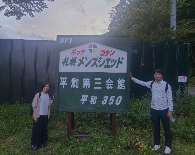


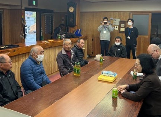
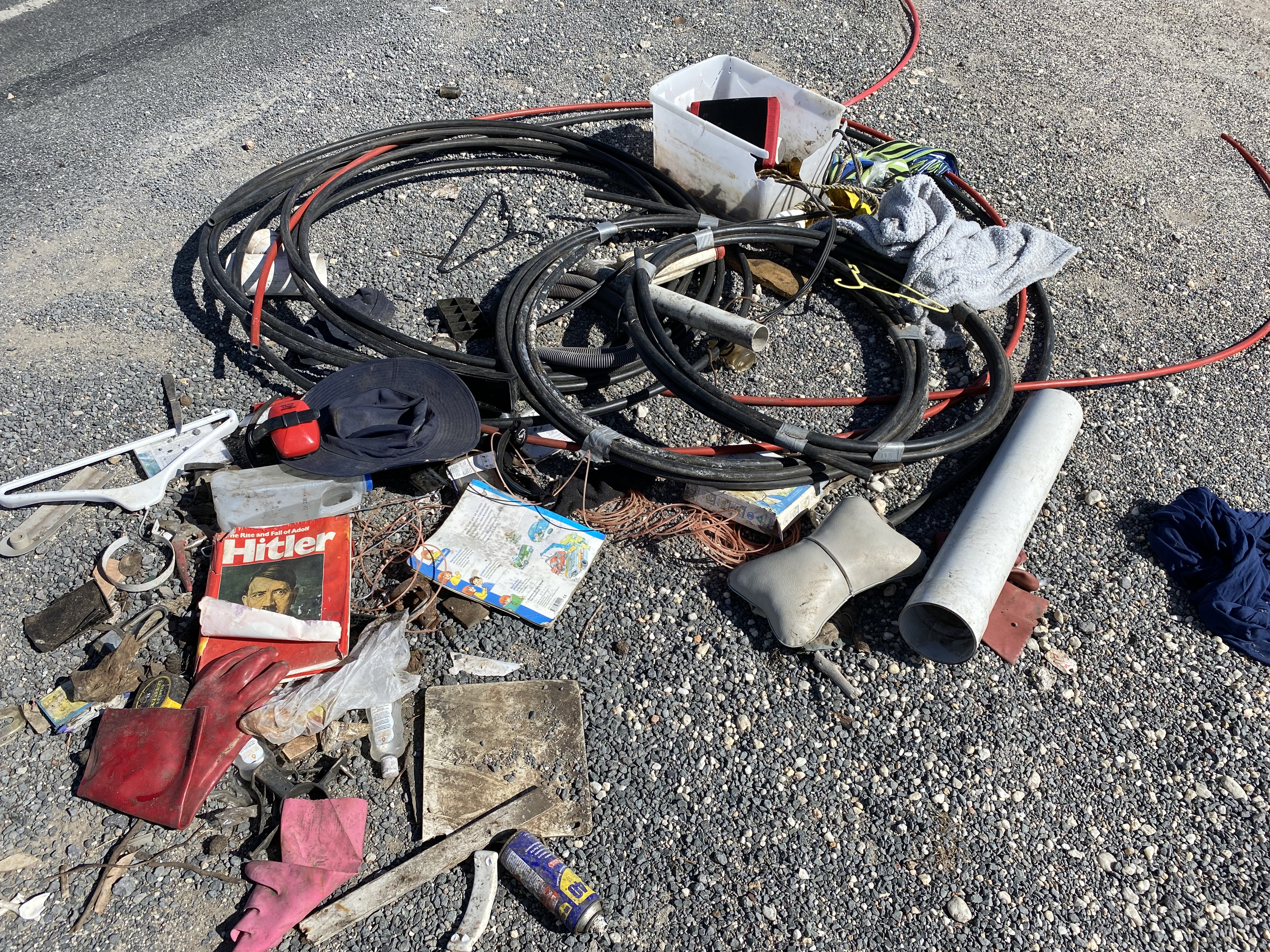

 Loddon Aboriginal Protectorate-Era (1840s) flour mill on The Mill Stream south of Franklinford


You must be logged in to post a comment.